cieldumort
Moderator

Reged: Mon
Posts: 2305
Loc: Austin, Tx
|
|
10AM CT Update 25 May 2018
Advisories for Subtropical Storm Alberto will begin at 11AM this morning.
5AM CT Update 25 May 2018
An organized LLC appears to be developing just off the eastern Yucatan this predawn, with pressures falling at a good clip. Maximum sustained winds as indicated by scatterometer, buoy and ship data support going directly to Alberto upon becoming a numbered cyclone. Should confirm current trends, Advisories on Alberto may begin as soon as today.
-Ciel

Quick 5PM Update 24 May 2018
90L has improved its appearance a great deal this afternoon, wtih a 90% chance for development now, it may develop as early as sometime tomorrow.
Current model trends show a potential impact to the north and northeaster Gulf, with rainfall extending east to Florida peninsula as well this weekend. There is a bit of concern the slow forward motion toward the end of the run may provide some time for strengthening, possibly to hurricane strength, so it is important to keep watch on this system for those in the MS/AL and Florida Panhandle areas.

Quick 9AM Update 24 May 2018

Development chances for Alberto (Tropical or Subtropical) are up to 80%, bringing a good bit of rain. Landfall will likely be somewhere between the MS/LA state line and Panama City Beach, FL. However most of the rain will be on the east side (and sometimes very east) of the center.
On/Off Bands of rain will likely start on Saturday for most of Florida, then moving up to include the Northeast Gulf as the weekend progresses, probably through Monday/Tuesday.
There may be some short lived Tornadoes in a few areas east of the center, so look out for watches if they do come.
There may be some minor storm surge along the north gulf points east of landfall as well.
Those from MS to the Big Bend will want to watch this system very closely for changes, there is a small window for intensification Sunday.
Original Update

A Central American Gyre (CAG) interacting with a stubborn mid-upper level trof over the southern states and Gulf is producing an area of disturbed weather that is gradually organizing in the northwest Caribbean. This expansive hybrid system is being tracked as Invest 90L - not to be confused with the similar, but less coherent, hybrid feature we were watching in the GOM just ten days ago.
What is truly remarkable, is how stubborn this pattern continues to be, already having flipped the Florida dry season on its head in next to no time, and now with even greater chances of a named system, one possibly lingering for several days to come.
With nearly all subtropical and tropical cyclones in general, and certainly the slower moving ones in particular, inland flooding is by far the greatest threat to life and property, and that would be no surprise here, especially given how saturated much of the area already is, and how long this system - and its parents, the Upper Trof and/or the Central American Gyre, may stick around.
According to Dr. Klotzbach, since 1950 only 8 named storms have formed during the last week of May in the Atlantic. In fact, no named storms on record have formed in the GOM at all during this time, so should 90L become Alberto here (very possible), it would indeed be something for the books.
Tropical or subtropical cyclogenesis could happen as soon as later today, with odds forecast to be increasing heading into the weekend. Recent ship and buoy reports suggest that maximum sustained winds associated with 90L may already be on the rise, and based on satellite imagery, so is deep convection. Thus, it would not be inconceivable to see begin advisories on this "Potential Tropical Cyclone" prior to formation given how close it is to land. (In fact, at the time of this entry, 90L's "center" appears to be inland or just barely offshore of the Yucatan).
Invest 90L Model Discussions and Speculations 90L Lounge
Northeast Gulf Links
Southeast Composite Radar Loop
(Latest Static)
Tampa Bay, FL Radar Radar Loop
(Latest Static)
Key West, FL Radar Radar Loop
(Latest Static)
Mobile, AL Radar Radar Loop
(Latest Static)
Tallahassee FL Radar Radar Loop
(Latest Static)
Northwest Florida Radar Radar Loop
(Latest Static)
Gulf of Mexico Satellite Imagery
SFWMD Full Florida Radar (Includes east LA, MS,AL) Loop with Storm Track
Area Forecast Discussions:
New Orleans -
Mississippi/Alabama/Pensacola -
Panhandle/Tallahassee -
Tampa/West Central Florida
Florida Power Outage Maps
Duke Energy Florida Outage Map - Most of Central and Northern Florida
Florida Power and Light Outage Map (Much of South Florida)
Orlando Utilities Commision Outage Map
Tampa Electric Outage Map
JEA (Jacksonville) Outage Map
Gulf Power (Western Panhandle)
Clay Electric Outage Map (Gainsville/ North Central Florida area)
Lakeland Electric Outage Map
Peace River Electrical Cooperative outage map south Central Florida from east of Bradenton, north of North Port to West of Palm Bay and Vero Beach
East Florida Links
Southeast Composite Radar Loop
(Latest Static)
South to North:
Key West, FL Radar Radar Loop
(Latest Static)
Miami, FL Radar Radar Loop
(Latest Static)
Melbourne, FL Radar Radar Loop
(Latest Static)
Jacksonville, FL Radar Radar Loop
(Latest Static)
Caribbean/South East Coast Satellite Imagery
SFWMD Radar Loop of South Florida with storm Track
SFWMD Full Florida Radar Loop with Storm Track
Area Forecast Discussions:
FLorida Keys -
Miami/South Florida -
Melbourne/East Central Florida -
Jacksonville/Northeast Florida -
Mississippi/Alabama Gulf Coast Media/Links
WLOX TV 13 (ABC) Biloxi
WXXV TV 25 (Fox)Biloxi
WKRG TV 5 (CBS) Mobile
WPMI TV 15 (NBC) Mobile
WALA TV 10 (Fox) Mobile
WEAR TV 3 (ABC) Pensacola, FL
Newspapers
Mobile Register (Al.com) paper
Biloxi Sun Herald paper
Gulf Live
Radio (some)
News Talk 104.9 Biloxi, MS (Radio)
News talk 106.5 Mobile, AL (Radio)
Power Outage
Louisiana power outage map
Mississippi Power Outage Map
Alabama Power Outage Map
Alberto Event Related Links

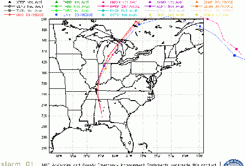
SFWMD Model Plot (Animated Model Plot) SFWMD Hurricane Page
[https://flhurricane.com/floatanimator.php?year=2018&storm=1 Flhurricane Satellite Floater Animation of Alberto
GOES Floater
Animated Model Plot of Alberto
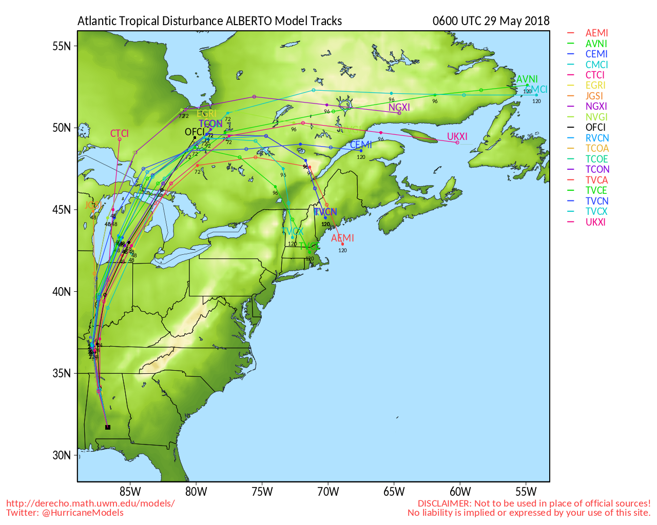
Clark Evans Track Model Plot of Alberto
(Animated!) Model Plots in Google Earth - In Google Maps
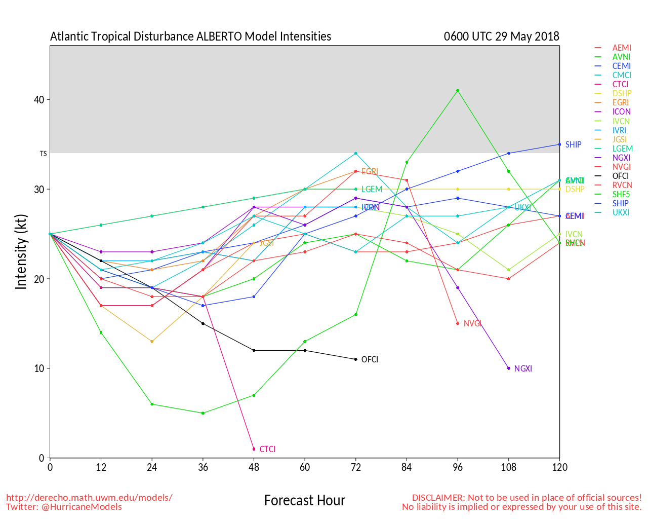
Clark Evans Intensity Model Plot of Alberto (Animated!)
Clark Evans Track Plot of Alberto
Other Model Charts from Clark
Clark Evans Top 10 Analog Storms for Alberto
More model runs on from RAL/Jonathan Vigh's page
NRL Info on Alberto -- RAMMB Info
COD Atlantic Satellite View
** Please note the floater satellite images linked above are old, nothing new using the new GOES-16 exists yet that matches *
Edited by MikeC (Sun May 27 2018 08:24 PM)
|
MikeC
Admin
Reged: Sun
Posts: 4543
Loc: Orlando, FL
|
|
Recon has been scheduled for 90L, chances up to 90% now.
|
MikeC
Admin
Reged: Sun
Posts: 4543
Loc: Orlando, FL
|
|
Tropical Cyclone Formation Alert issued:
Wtnt21 Kngu 242330
Subj/Tropical Cyclone Formation Alert//
Rmks/
1. Formation of a Significant Tropical Cyclone Is Possible
Within 160 Nm Either Side of a Line From 17.7n 88.2w to 25.1n 87.0w
Within the Next 24 Hours. Available Data Does Not Justify Issuance
Of Numbered Tropical Cyclone Warnings at This Time. Winds in The
Area Are Estimated to Be 30 Knots. Metsat Imagery at 242000z
Indicates That a Circulation Center Is Located Near 19.3n 88.2w. The
System Is Drifting North-northeastward at 02 Knots.
2. Remarks: A Low Pressure System Located Inland Over the Eastern
Portion of the Yucatan Peninsula Is Gradually Becoming Better
Defined.
The System Is Producing a Disorganized Area of Showers And
Thunderstorms Over the Northwestern Caribbean and Yucatan Channel
With Winds of 30 Kts. Environmental Conditions Are Expected To
Become More Favorable for Developement Friday and Saturday and A
Subtropical or Tropical Cyclone Is Likely to Form While the Low
Moves Into the Southern Gulf of Mexico.
3. This Alert Will Be Reissued, Upgraded to Warning or Cancelled By
252330z.//
|
OrlandoDan
Weather Master

Reged: Mon
Posts: 443
Loc: Longwood, FL
|
|
90L has been named subtropical storm Alberto. Breakout the umbrella, Florida. Going to be a wet Memorial Day weekend.
--------------------
Keith (1988), Charley (2004), Frances (2004) , Jeanne (2004), Fay (2008), Mathew (2016), Irma (2017), Dorian (2019)
Personal Weather Station: https://www.wunderground.com/dashboard/pws/KFLLONGW67
|
Doombot!
Weather Guru

Reged: Sat
Posts: 160
Loc: Lakeland, Fl.
|
|
It's been a wet week already...
|
MARK053162
Registered User
Reged: Fri
Posts: 1
Loc:
|
|
It looks on satellite the center continues to move east southeast There also seems like another circulation further northeast nearer to the convection. Will have to watch if this trend continues and if a new center forms further northeast..
|
Doombot!
Weather Guru
Reged: Sat
Posts: 160
Loc: Lakeland, Fl.
|
|
I doubt anyone would be supprised.
The sooner this thing gets and established LLC, the quicker the models can get a handle on it.
|
craigm
Storm Tracker

Reged: Wed
Posts: 327
Loc: Palm City, Florida
|
|
Quote:
It looks on satellite the center continues to move east southeast There also seems like another circulation further northeast nearer to the convection. Will have to watch if this trend continues and if a new center forms further northeast..
Agree there is definitely an exposed LLC still heading to the east and the whole mess is tilted by shear to the NE.There are multiple vortices at different levels and the models must be picking up on something further to the north. We are seeing model runs that are 6 to 12 hours old with data input earlier than that. Will have to see if initialization starts to move east. Either way looks like just a rain event on already saturated ground for Florida and possibly more of an impact in the panhandle. BTW didn't last year start off like this?
http://rammb-slider.cira.colostate.edu/?...;s=rammb-slider
--------------------
Why I'm here:
Weather hobbyist
|
MikeC
Admin
Reged: Sun
Posts: 4543
Loc: Orlando, FL
|
|
The latest recon report with 997 is off the Northwest Tip of cuba, it also suggests Alberto is beinging to transition into a fully tropical storm.
|
Prospero
Storm Tracker

Reged: Fri
Posts: 267
Loc: Gulfport, FL
|
|
It appears GOES-East is not updating its images. The latest images seem to hint at some circulation, but then they stopped...
--------------------
Gulfport Florida Webcam - Gulfport Florida Weather Station - Clearwater Beach Cams
|
Prospero
Storm Tracker
Reged: Fri
Posts: 267
Loc: Gulfport, FL
|
|
I found this link, I like it better than what I had been looking at:
http://weather.cod.edu/satrad/exper/?par...;colorbars=data
--------------------
Gulfport Florida Webcam - Gulfport Florida Weather Station - Clearwater Beach Cams
|
kapSt.Cloud
Weather Hobbyist
Reged: Fri
Posts: 50
Loc: Long Beach, MS
|
|
Barometric Pressure took a nosedive from this morning which was 1005mb. Now 999mb! My migraines are reacting!
|
MikeC
Admin
Reged: Sun
Posts: 4543
Loc: Orlando, FL
|
|
Watching the satellite closely right now, still looks like a slight east of due north movement, still trying to transition to tropical, getting close.
|
EMS
Weather Hobbyist
Reged: Tue
Posts: 55
Loc: St. Petersburg, Florida
|
|
The center of circulation seemed to be getting better defined/more tropical in nature. But dry air now seems to have wrapped itself into the core and really diminished rain coverage.
|
MikeC
Admin
Reged: Sun
Posts: 4543
Loc: Orlando, FL
|
|
Yeah dry air from the south and west is affecting it, and making it appear to be moving northwest on radar (recon is finding it more N to NNW) The left bend/slowdown is supposed to occur sometime later today.
Between that and the cooler water in that part of the Gulf, chances of it becoming a hurricane are thankfully extremely low.
|
MikeC
Admin
Reged: Sun
Posts: 4543
Loc: Orlando, FL
|
|
Recon has been finding pressures dropping this morning, though, (994 mb) so when it does move over a bit warmer water it will still get a chance to become a bit stronger, probably not hurricane force, though.
|
MikeC
Admin
Reged: Sun
Posts: 4543
Loc: Orlando, FL
|
|
12Z showing a landfall near ft walton beach tomorrow around noon at 985mb (Strong TS/borderline hurricane) This system seems to be out of the strong easterly shear now and is beginning to wrap around to the west, pulling dry air in the south side, which hopefully will be enough to keep it away from hurricane strength. Model track is a bit iffy, so prefer the track. There's a big tail of rain east of Florida that will probably get pulled into the peninsula later today. Smaller, but stronger bands are coming up along the west coast (one near Naples right now) and another big band over N. Florida.
|
MikeC
Admin
Reged: Sun
Posts: 4543
Loc: Orlando, FL
|
|
System has veered quite a bit west of the official track, I've noticed. See the Florida Radar. (Similar to the UKMet track)
Tropical Conversion is nearly complete also.
|
MikeC
Admin
Reged: Sun
Posts: 4543
Loc: Orlando, FL
|
|
Still mainting 994/50mph probably until another recon flight arrives. Watching the motion of the storm closely tonight also.
The water vapor imagery does show the dry air being injected into the center of the storm from the s/sw .

|
MikeC
Admin
Reged: Sun
Posts: 4543
Loc: Orlando, FL
|
|
There was a special advisory issued tonight because recon found lower pressure and stronger winds. I figured they may have added a hurricane watch or warning because of how close it was getting, however the dry air intrusion is probably too much to make it get over, so I can't disagree with the call. The upper level WV shows dry air, lower level WV images show even more dry air coming in, it may be starved for moisture tomorrow morning.
|


 Threaded


