MikeC
Admin
Reged: Sun
Posts: 4543
Loc: Orlando, FL
|
|
8:00AM EDT 18 September 2021 Update
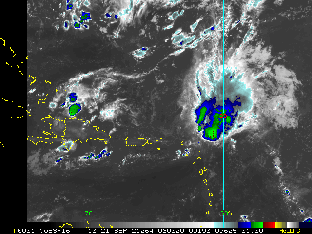
Invest 95L continues organizing as it heads generally west-northwestward through the Main Development Region of the Tropical Atlantic, now about 650 miles miles east-southeast of the northern Leeward Islands. The area of low pressure will very likely become a TD today or tomorrow (NHC 90%) and the northern Antilles could see some direct impacts and may want to watch. Tropical Storm Watches and Warnings could be issued at any time.
Most models expect 95L to begin recurving well before reaching the US coast, but this is not certain. Recon will be flying in and around the system and this invaluable data should greatly improve the forecast.
Elsewhere, Odette is a sheared barely Tropical Cyclone heading NE to E out to sea and will soon become Post-Tropical. Invest 97L south of the Cabo Verde Islands now has a 40% odds of development, is expected to turn northwestward soon and may brush those islands as a TD or or storm by early next week.
-Ciel
10:00PM CDT 13 September 2021 Update
Hurricane Nicholas has formed offshore of Matagorda Island and is moving generally parallel along the Texas coast offshore.
7:00PM CDT 13 September 2021 Update
Nicholas is right on the hurricane threshold with max 1-min sustained winds now 70 MPH. Strengthening is still ongoing and may continue during the overnight provided Nicholas remains over water, or enough over water, and it is conceivable that there could actually be just enough time to allow for a category higher than Cat 1. We shall see. Always best to prep for a category higher than forecast anyway, and in all practicality, there is a negligible difference between 70 MPH max and 74, so pretty much borderline Cat 1 already.
SUMMARY OF WATCHES AND WARNINGS IN EFFECT:
A Storm Surge Warning is in effect for...
* Port Aransas Texas to Sabine Pass
* Galveston Bay, Aransas Bay, San Antonio Bay, and Matagorda Bay
A Hurricane Watch is in effect for...
* Port Aransas to San Luis Pass Texas
A Tropical Storm Warning is in effect for...
* Baffin Bay to Sabine Pass
A Storm Surge Watch is in effect for...
* Sabine Pass to Rutherford Beach Louisiana
Additionally, Flash Flood Watches are presently in effect for at least the following counties.
In South Central and Southeast Texas:
Coastal Jackson and Inland Jackson. In southeast Texas, Bolivar Peninsula, Brazoria Islands, Chambers, Coastal Brazoria, Coastal Galveston, Coastal Harris, Coastal Matagorda, Fort Bend, Galveston Island, Inland Brazoria, Inland Galveston, Inland Harris, Inland Matagorda, Matagorda Islands, Northern Liberty, Southern Liberty and Wharton.
A portion of south Texas:
Aransas IIslands, Calhoun Islands, Coastal Aransas, Coastal Calhoun, Coastal Refugio, Inland Calhoun, Inland Refugio and Victoria.
Additional portions of Louisiana and southeast Texas, including the following areas and parishes: in Louisiana, Acadia, Allen, Avoyelles,Beauregard, Calcasieu, East Cameron, Evangeline, Iberia, Jefferson Davis, Lafayette, Lower St. Martin, Rapides, St. Landry, St. Mary, Upper St. Martin, Vermilion, Vernon and West Cameron. In southeast Texas, Hardin, Jefferson, Northern Jasper, Northern Newton, Orange, Southern Jasper, Southern Newton and Tyler.
Among others. A HIGH RISK of Flash Flooding is currently in effect for a sizable portion of southeast Texas with Moderate-High Risk that includes the Houston-Galveston area. A HIGH RISK of Flash Flooding means that the rainfall and flooding specialists over at WPC see a setup for potentially 'severe, widespread flash flooding, including areas that don't normally experience flash flooding.'
-Ciel
10:00AM CDT 13 September 2021 Update
Nicholas appears to have yet another center jump north in mind, so we will see if this does anything like it did so amazingly well last night (possibly a record for distance jumping in a single leap then). The stronger winds and heavier precip may start to arrive ahead of schedule on the coast and inland should this process complete.
-Ciel
4:00PM CDT 12 September 2021 Update
Nicholas is still attempting to form a cohesive center, and the forecast track has shifted slightly to the left, but the angle of approach makes specifics difficult, because of this...
A Hurricane Watch has been issued for the coast of Texas from Port Aransas to Sargent. As there exists the possibility, if Nicholas stays over the water longer, for it to reach hurricane strength before landfall.
The Tropical Storm Warning has been extended eastward to Freeport, Texas.
10:00AM CDT 12 September 2021 Update
Tropical Storm Nicholas has formed int he Bay of Campeche.
A Tropical Storm Warning is in effect for the coast of Texas from the Mouth of the Rio Grande to Port Aransas.
The Government of Mexico has issued a Tropical Storm Warning from Barra el Mezquital northward to the U.S./Mexico border.
A Storm Surge Watch is in effect for the coast of Texas from the Mouth of the Rio Grande to High Island.
A Tropical Storm Watch is in effect for the coast of Texas from north of Port Aransas to High Island.
9:20AM CDT 12 September 2021 Update
Advisories for Potential Tropical Cyclone 14 will begin soon. (Was Invest 94L)
5:45AM CDT 12 September 2021 Update
Invest 94L appears to be both organizing roughly on to a little ahead of most models' schedules, but also taking on what could be a somewhat larger size than some runs expected.
Interests from Tampico, MX to New Orleans, LA and points inland may want to begin paying close attention, as while almost certainly to become a Tropical Cyclone today or tomorrow, this system will be lingering over the same general area for days and days, dousing many locations in frequent if not persistent heavy rainfall. Grounds are already saturated in much of east Texas and Louisiana. In addition, much of Louisiana is still picking up the pieces from Ida.
The Forecast Lounge for 94Lwill be a good place to tease out model trends on this one. Recon should be headed in later today and that data will soon be assimilated by model runs.
We are now at climatological peak season during a hyperactive year within the active phase of the Atlantic basin, and systems can more easily pop and develop quickly and perhaps even unexpectedly, around this time.
-Ciel
Original Entry
The area in the Bay of Campeche (94L) currently has an 90% chance to develop over the next 48 hours, and those in Texas and Louisiana will want to watch it very closely, as it could become a hurricane.
Two areas off Africa have a 50% and 40% respectively chance to develop.
30 percent for the area near the Bahamas,
Lots of various activity going on.
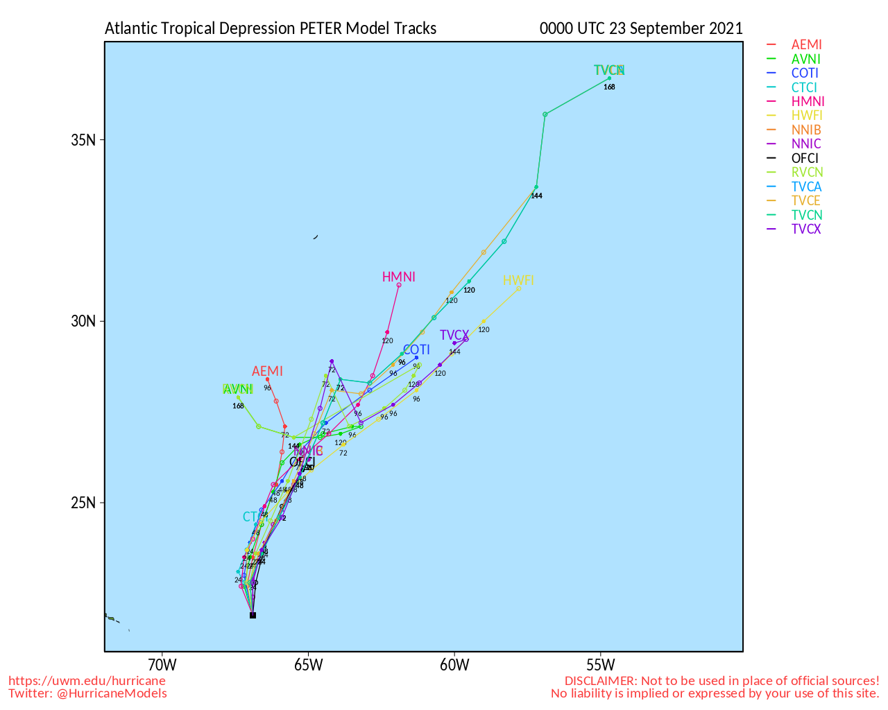
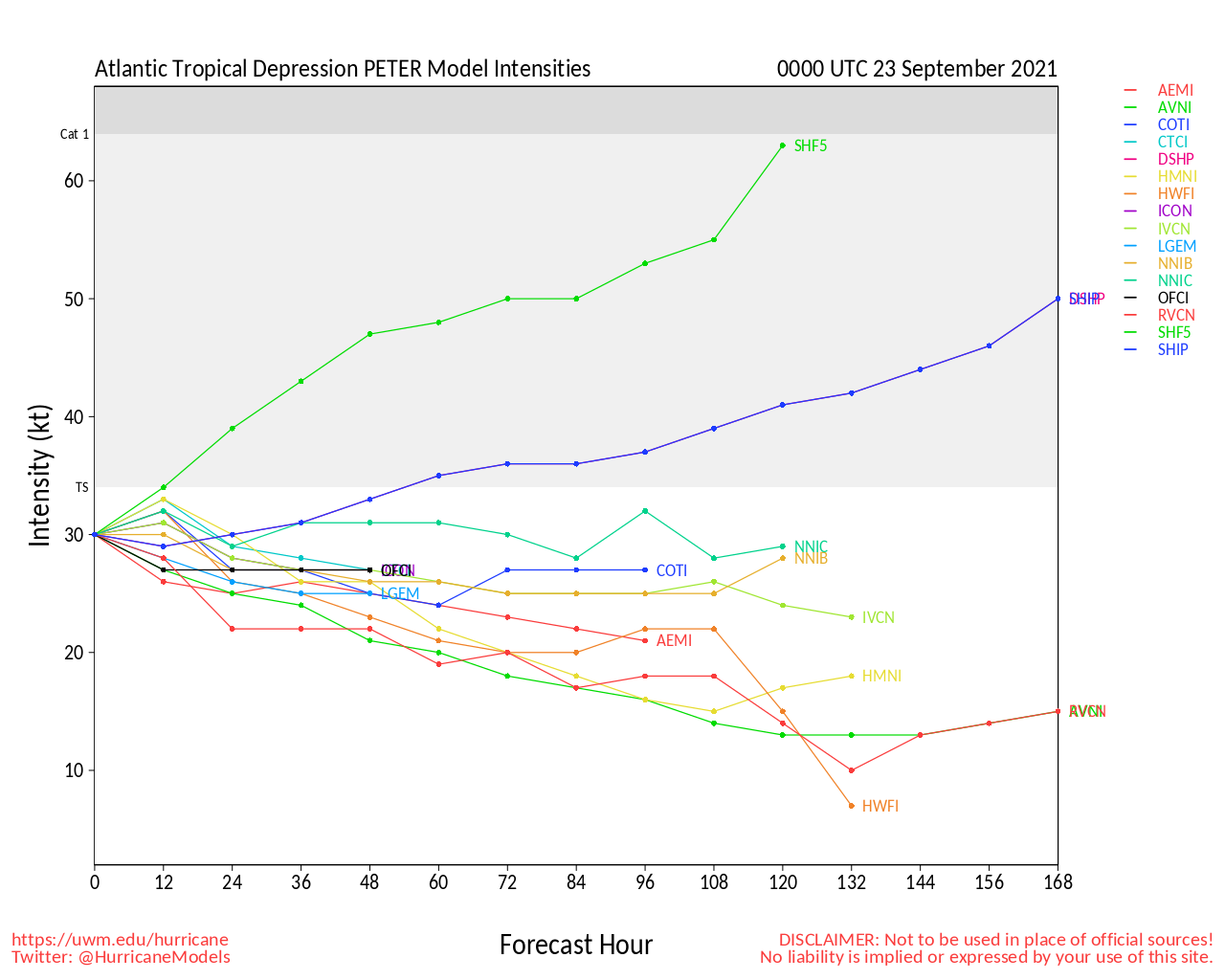
Peter Event Related Links
SFWMD Model Plot (Animated Model Plot) SFWMD Hurricane Page
[https://flhurricane.com/floatanimator.php?year=2021&storm=16 Flhurricane Satellite Floater Animation of Peter
GOES Floater
Animated Model Plot of Peter
Clark Evans Track Model Plot of Peter
(Animated!) Model Plots in Google Earth - In Google Maps
Clark Evans Intensity Model Plot of Peter (Animated!)
Clark Evans Track Plot of Peter
Other Model Charts from Clark
Clark Evans Top 10 Analog Storms for Peter
More model runs on from RAL/Jonathan Vigh's page
NRL Info on Peter -- RAMMB Info
COD Atlantic Satellite View
Tropical Depression Seventeen Event Related Links
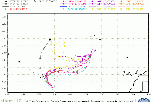
SFWMD Model Plot (Animated Model Plot) SFWMD Hurricane Page
[https://flhurricane.com/floatanimator.php?year=2021&storm=17 Flhurricane Satellite Floater Animation of TD17
GOES Floater
Animated Model Plot of TD17
Clark Evans Track Model Plot of TD17
(Animated!) Model Plots in Google Earth - In Google Maps
Clark Evans Intensity Model Plot of TD17 (Animated!)
Clark Evans Track Plot of TD17
Other Model Charts from Clark
Clark Evans Top 10 Analog Storms for TD17
More model runs on from RAL/Jonathan Vigh's page
NRL Info on TD17 -- RAMMB Info
COD Atlantic Satellite View
Texas Gulf Coast Links
[http://moe.met.fsu.edu/~mnissenbaum/radar.html Mark Nissenbaum's radar page}
East to West:
Houston/Galveston, TX Radar Radar Loop
(Latest Static)
Corpus Christi, TX Radar Radar Loop
(Latest Static)
Brownsville, TX Radar Radar Loop
(Latest Static)
Gulf of Mexico Satellite Imagery
Area Forecast Discussions:
Houston/Galveston, TX
- Corpus Christi, TX - Browsnville/South Padre Island, TX
|
cieldumort
Moderator

Reged: Mon
Posts: 2305
Loc: Austin, Tx
|
|
Worth noting that the current recon mission into Nicholas is finding the sloppy center trending left and yet more left still of forecast positions, now with almost all the deep convection well to his north and northeast.
A center reformation downshear into the deeper convection remains very possible, but not certain. A continued track of the surface low to the left and away from the convection right at the time models suggested shear would be starting to relax does not build a lot of confidence in the current forecast. Bears watching. Mexico may be more in play after all for a weaker but still wet system.
|
cieldumort
Moderator
Reged: Mon
Posts: 2305
Loc: Austin, Tx
|
|
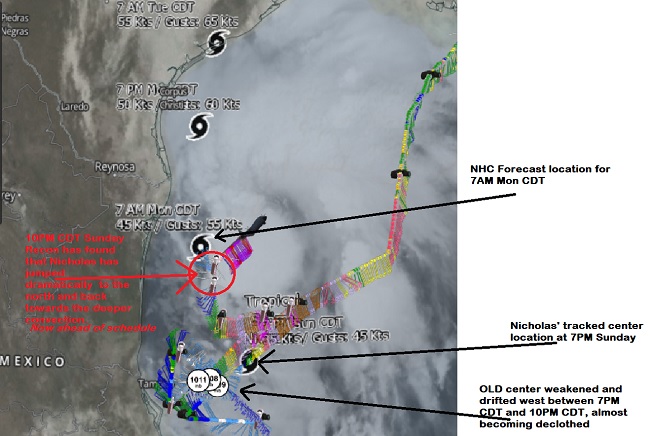
Recon has just found that Nicholas is likely in the process of or has just completed a rather dramatic center reformation into the deeper convection well to the north of the old LLC that itself is now rapidly weakening and tracking west towards Mexico.
The image below captures the recon mission winds, vorts, IR satellite, and forecast track as of 7PM. This likely center reformation puts Nicholas much closer to the forecast location for 7AM Monday morning, and also suggests that the formative cyclone may continue to be a jumpy one in response to the southwesterly shear - with inclement weather moving onshore of Texas and Louisiana sooner rather than later.
This could also increase the odds of further rightward adjustments in the official forecast track, and they have alluded to this with the 10PM Advisory.
--------------------
Fully vaccinated as of May 2021
(Moderna x2)
|
cieldumort
Moderator
Reged: Mon
Posts: 2305
Loc: Austin, Tx
|
|
|
|


 Threaded


