danielw
Moderator

Reged: Wed
Posts: 3525
Loc: Hattiesburg,MS (31.3N 89.3W)
|
|
19 June 5:00PM EDT Update
...TROPICAL STORM WARNING ISSUED FOR PART OF THE LOUISIANA COAST...
Invest 93L is expected to become a named storm and affect much of the northern Gulf coast this week. 93L is now being tracked as Potential Tropical Cyclone THREE, and advisories have begun
- Ciel
18 June 8:00PM EDT Update
...TROPICAL STORM WARNING ISSUED FOR PORTIONS OF THE SOUTHERN WINDWARD ISLANDS...
In the interest of public safety, now has the option of issuing advisories on systems that are likely to develop, but may do so in such a way that to wait to start advisories on the 'Potential Tropical Cyclone' to verify (form), residents, emergency managers, entire governments, etc., would not be able to prepare in a timely manner. Such is the case with Invest 92L this afternoon. Tropical Storm conditions are expected in the southern Lesser Antilles whether or not 92L even becomes a bona fide tropical cyclone (although it is).
From Quote:
The disturbance over the deep tropical Atlantic has become better organized today, although a pair of ASCAT-A and B passes this morning indicated that the system does not have a closed low-level circulation, which isn't surprising given the fast translational speed of the system. The ASCAT passes showed peak winds of near 30 kt well north of the center, and given that the environment is expected to be conducive for some additional development before the shear increases in the eastern Caribbean Sea, strengthening is forecast, and the disturbance is expected to become a tropical storm before reaching the Windward Islands in 36 to 48 hours.
The National Hurricane Center now has the option to issue advisories on disturbances that are not yet tropical cyclones, but which pose the threat of bringing tropical storm or hurricane conditions to land areas within 48 hours. Under previous policy this was not possible. These systems are known as Potential Tropical Cyclones in
advisory products and are numbered from the same list as depressions. Because of the threat to the Windward Islands, advisories have been initiated on Potential Tropical Cyclone Two and the appropriate warnings have been issued by the respective governments in the Windward Islands. Advisory packages will continue until the threat of tropical-storm-force winds for land areas sufficiently diminishes, although if the system becomes a tropical cyclone, the normal rules for discontinuing advisories would apply. Users should be aware that forecast uncertainty for disturbances is generally larger than for tropical cyclones, especially beyond 48-72 hours.
-Ciel
18 June 3:30PM EDT Update
For 93L, Aircraft Recon Cancelled for lack of a defined center. Trough extends from "Best track" on graphic toward the tip of Cuba. System could develop anywhere along there. mid level likely won't move down. Western and North Central Gulf coasts (toward the Panhandle) need to keep watch on this system, things could change once it makes it into the Gulf of Mexico.

The strength of the storm may not be as important as the rainfall, all the tropical moisture streaming in to the Gulf states on the system could cause a rainfall threat.
18 June 7AM EDT Update
93L is looking better organized this morning, and the models are slowly converging on an area between TX and the Florida Panhandle, with potential impacts as soon as Tuesday night those along these ares should monitor it closely. Expect a typical June sloppy system, but it is possible this could develop somewhat rapidly once in the Gulf, so it is very important to monitor it.
Hurricane Hunter aircraft are scheduled to check the area out today.

92L East of the islands is likely to have an impact on the southern leewards, but chances for development are down, at the very least it will bring a fair amount of rainfall for the islands, beyond that it is expected to be sheared apart in the east Caribbean.
If two storms become active in June at the same time, it will be the first time that has happened since 1968.
16 June 9PM EDT Update
The system in the Central Atlantic is now being tracked as Invest 92L. This system has a 60% chance for development over the next 5 days, and is heading generally westward toward the Southern Leeward islands. Based on model runs it would be near there on Tuesday.

The area in the Western Caribbean looks better this evening, but is still not an invest. Models diverge between a western Gulf of Mexico or Eastern Gulf of Mexico scenario, with the western one being slightly more probable. Still too soon to tell what happens with this system, it will likely cover a large area and bring a lot of moisture to wherever it goes. If it affects the Eastern gulf it would be Tuesday/Wed, if it moves west toward Mexico it would be mid to late next week. Check back over the weekend for any changes.
Original Update
NHC has recently upgraded the probability of Tropical Cyclone formation in the North Western Caribbean and Yucatan Peninsula Area to 50% over the next 5 days.
This is an area to watch on the next few days and over the weekend. Nothing too concerning right now other than another round of enhanced rains for Florida and possibly other parts of the Gulf, but there is enough of a chance that something may develop out of it to keep an eye on.
It's important to note that odds favor a disorganized rain maker, but based on models it could form to be a strong tropical storm in the Gulf on Monday or so, thus it's worth keeping a close eye on.
<a href="http://www.nhc.noaa.gov/gtwo.php?basin=atlc&fdays=5" target="_blank">Latest 5 day Outlook from the National Hurricane Center</a>
<a href="http://tropic.ssec.wisc.edu/real-time/mimic-tpw/natl/main.html" target="_blank">CIMSS North Atlantic Water Vapor Loop</a>
More information will come later, nothing has been tagged as an invest yet. Lounge discussion can be found <a href="http://flhurricane.com/cyclone/showflat.php?Number=97643&gonew=1#UNREAD" target="_blank">Here</a> for this system.
Biloxi Lightgouse camera Live Stream:

<a href="http://flhurricane.com/imageanimator.php?252" target="_blank">Flhurricane Recording of Biloxi Lighthouse Cam</a>
Mark Sudduth/Hurricanetrack Video Stream for the system
See mark's position on a map here.
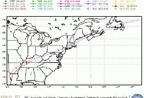
Potential 3 (Was 93L/Gulf) Event Related Links

SFWMD Model Plot (Animated Model Plot) SFWMD Hurricane Page
[https://flhurricane.com/floatanimator.php?year=2017&storm=3 Flhurricane Satellite Floater Animation of Potential 3
GOES Floater
Animated Model Plot of Potential 3
Clark Evans Track Model Plot of Potential 3
(Animated!) Model Plots in Google Earth - In Google Maps
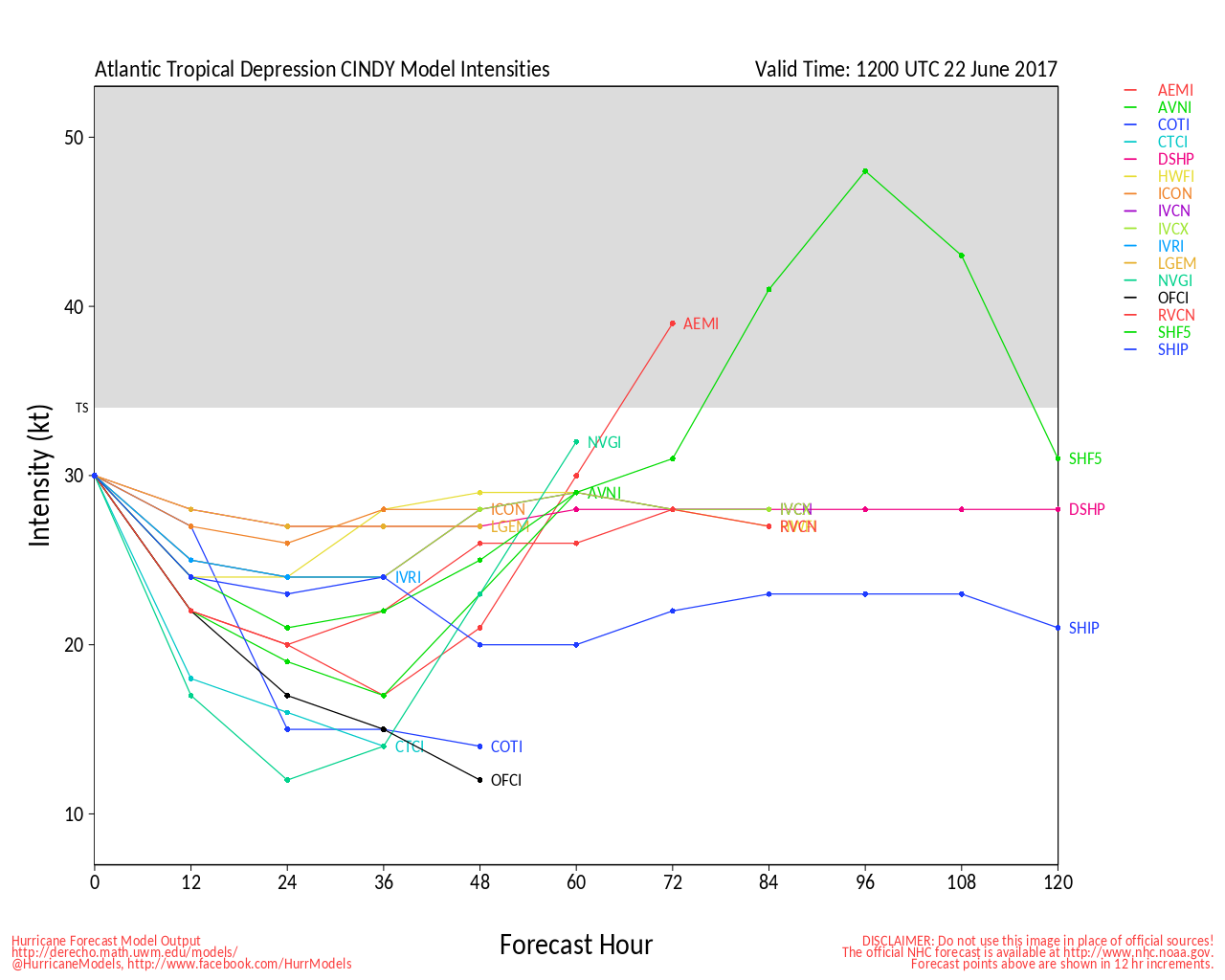
Clark Evans Intensity Model Plot of Potential 3 (Animated!)
Clark Evans Track Plot of Potential 3
Other Model Charts from Clark
Clark Evans Top 10 Analog Storms for Potential 3
More model runs on from RAL/Jonathan Vigh's page
NRL Info on Potential 3 -- RAMMB Info
COD Atlantic Satellite View
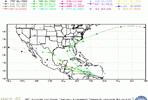
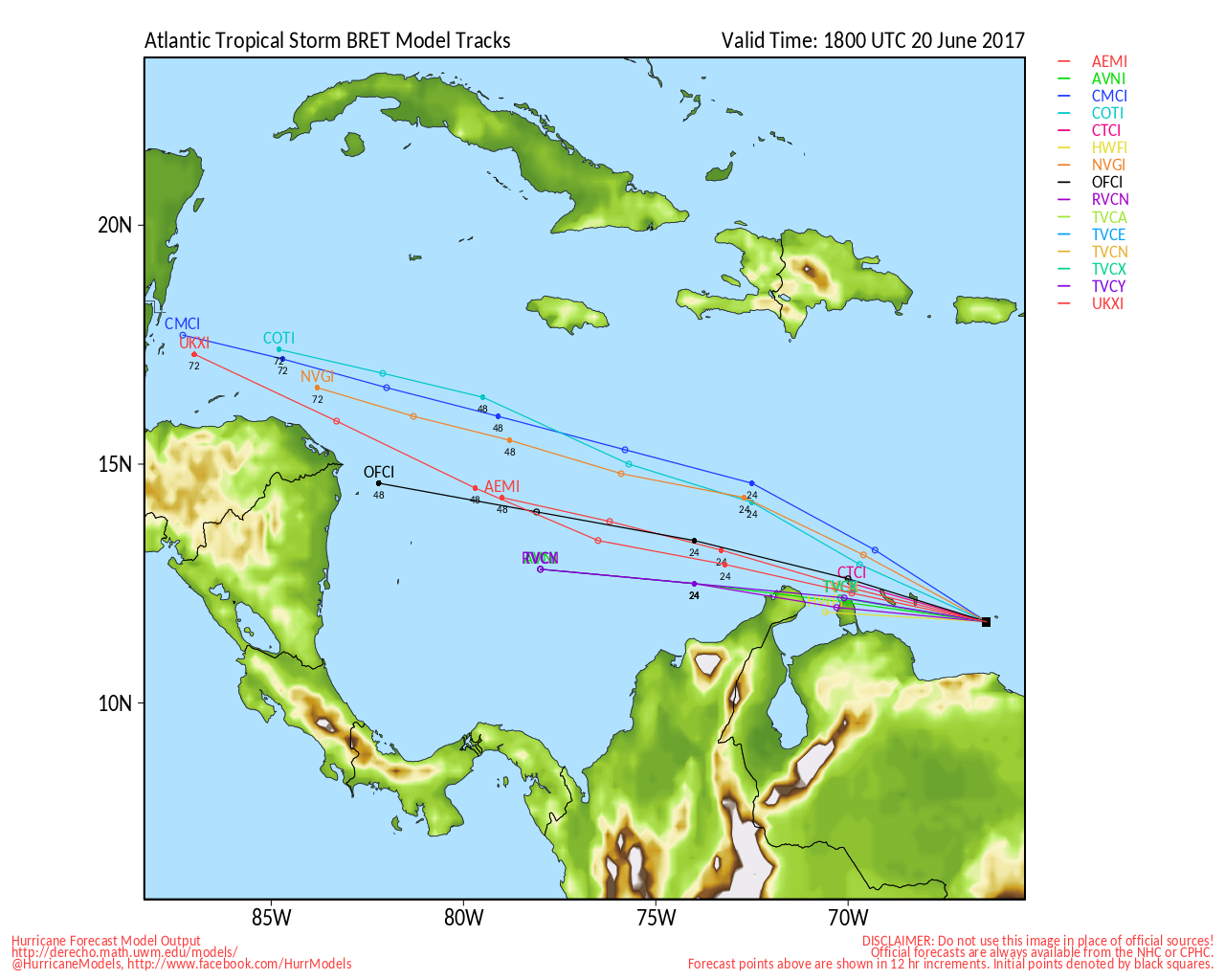
Bret) Event Related Links

SFWMD Model Plot (Animated Model Plot) SFWMD Hurricane Page
[https://flhurricane.com/floatanimator.php?year=2017&storm=2 Flhurricane Satellite Floater Animation of Bret
GOES Floater
Animated Model Plot of Bret
Clark Evans Track Model Plot of Bret
(Animated!) Model Plots in Google Earth - In Google Maps
Clark Evans Intensity Model Plot of Bret (Animated!)
Clark Evans Track Plot of Bret
Other Model Charts from Clark
Clark Evans Top 10 Analog Storms for Bret
More model runs on from RAL/Jonathan Vigh's page
NRL Info on Bret -- RAMMB Info
COD Atlantic Satellite View
StormCarib Reports from the Caribbean Islands
Caribbean Weather Observations
Barbados Brohav Weather Fax
Full Caribbean Radar Composite
Caribbean Broadcast Corporation (TV/Radio from Antilles)
San Juan, PR NWS Page
Various Caribbean Radio Stations
DR1 Dominican Republic Hurricanes
Louisiana Coastal Links
North Gulf/Southern Mississippi Valley Composite Radar Loop
(Latest Static)
East to West:
New Orleans, LA Radar Radar Loop
(Latest Static)
Lake Charles, LA Radar Radar Loop
(Latest Static)
Gulf of Mexico Satellite Imagery
Area Forecast Discussions:
New Orleans, LA -
Lake Charles, LA -
Edited by MikeC (Tue Jun 20 2017 12:45 PM)
|
cieldumort
Moderator

Reged: Mon
Posts: 2305
Loc: Austin, Tx
|
|
There has been some buzz within the social mediarologist sphere that the cyclonic convective complex which developed on the eastern side of the parent gyre is a tropical cyclone. This is probably not the case. Surface winds around the MCS are generally blowing as is typical for the area - from SE to NW, or in spots, towards the 'X" on the map below - and surface pressures near the MCS are presently rising.
For two days a tropical wave has been interacting with the gyre, and this has resulted in numerous rounds of heavy showers and thunderstorms, some quite vigorous, to the right of 93L's center. Overnight last night the most organized complex yet developed, and *could* have had a low-level circulation associated with it, but so far, this is unclear at best.
It is worth noting that of the models that create a primary surface low to the northeast to north of 93L's present 'center,' it appears that this is at least partially responsible for how they do it (by tapping into the additional vorticity and instability created by the introduction of this unrelated tropical wave), and so the area does bear close watching. Even though 93L's center is most likely the weak LLC near the border of Belize & Mexico, this center could 'jump' into one of these mid-level thunderstorm convective complexes, under the right circumstances.
Recon is scheduled to be flying in later today, and that data should help greatly in ascertaining the viability of this thunderstorm complex, as well as with the next round of model initialization.

|
cieldumort
Moderator
Reged: Mon
Posts: 2305
Loc: Austin, Tx
|
|
Because of the obvious lack of sufficient organization, the recon mission for today has been cancelled.
|
EMS
Weather Hobbyist
Reged: Tue
Posts: 55
Loc: St. Petersburg, Florida
|
|
Thanks to everyone for all the great info as usual.
Satellite seemed to show a center trying to form around 19N, 83.5W. Of course satellite can be deceptive - not sure whether it's a low or mid-level spin, or if it's just one of the number of vortices that usually spin up in the formation stages.
|
SouthGAwx
Verified CFHC User
Reged: Fri
Posts: 16
Loc: Georgia
|
|
2 PM still indicates that the recon flight for 93L is scheduled for later this afternoon?
|
SouthGAwx
Verified CFHC User
Reged: Fri
Posts: 16
Loc: Georgia
|
|
Confirmed - Second aircraft is indeed airborne from Biloxi to investigate 93L now.
|
MikeC
Admin
Reged: Sun
Posts: 4543
Loc: Orlando, FL
|
|
Yes recon is en route now. (Tropical Cyclone Formation Alert) has gone up for 93L also, may become a depression soon.
|
MikeC
Admin
Reged: Sun
Posts: 4543
Loc: Orlando, FL
|
|
Recon was unable to close off 93L, it's heading back in. Next flight is at 5:30 AM tomorrow.
|
MikeC
Admin
Reged: Sun
Posts: 4543
Loc: Orlando, FL
|
|
Rainfall will be the story with the area in the Gulf.
Bret Radar recording (Trinidad & Tabago)
Gulf Radar recording (N. Gulf Radar)
|
MikeC
Admin
Reged: Sun
Posts: 4543
Loc: Orlando, FL
|
|
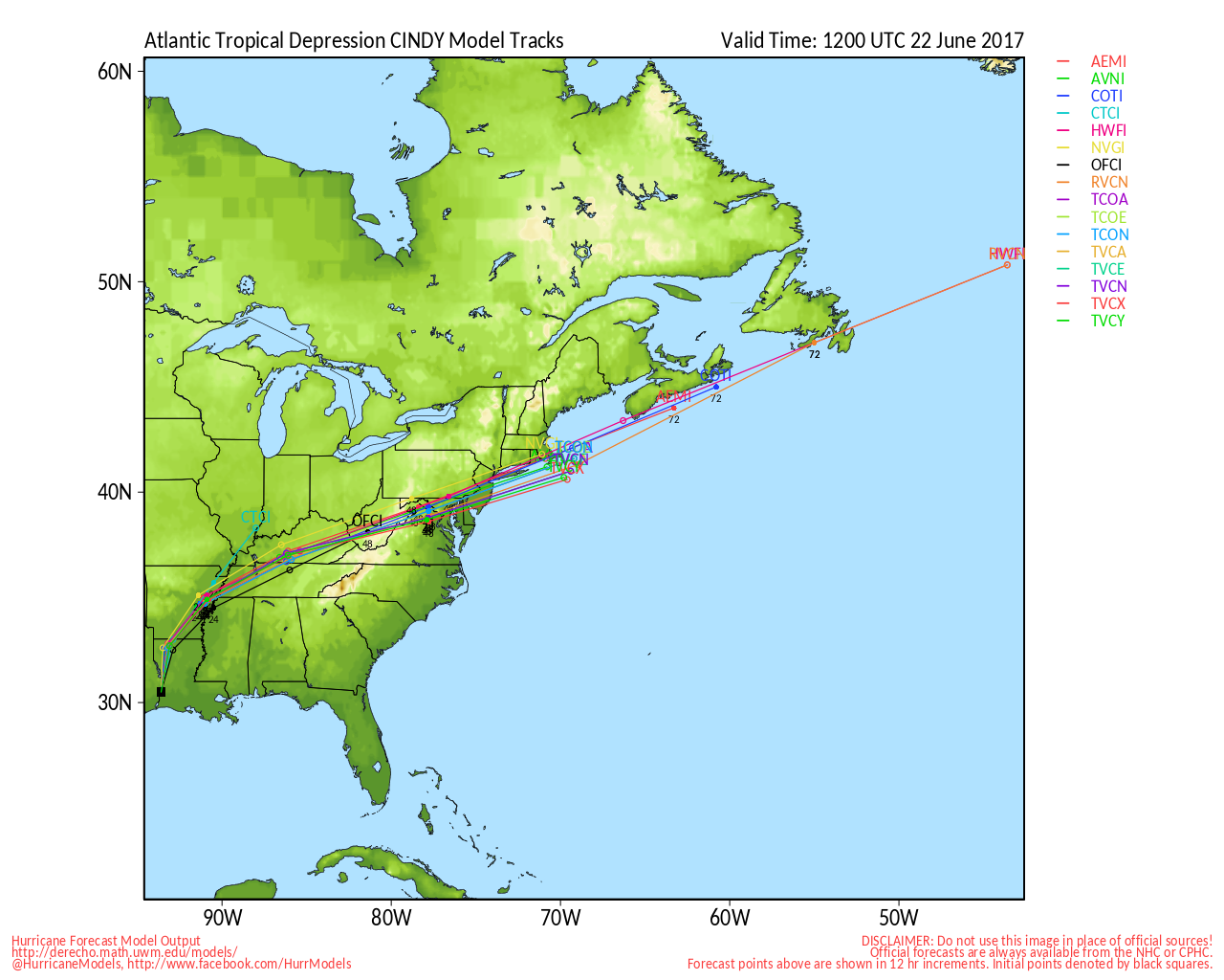
The center of the storm seems to be moving (or reforming) closer to the convection this morning, and is a bit east/north of the earlier forecast point, which suggests the track may be shifted back a bit east toward Central Louisiana (and sooner),
The rainfall with this system, on the east side of the storm, is the main threat here. Folks west of the center won't see much of anything. Even beyond landfall the system will likely cause flooding issues in MS, TN, AL, and parts of Georgia.
The upper level low is shifting away from the system today, giving it a window to strengthen, there may be some coastal flooding in a few areas also, to the east of the landfall point.
Short lived Tornados in some of the bands may occur, even well east of the system (all the way to the panhandle of Florida)
|
cieldumort
Moderator
Reged: Mon
Posts: 2305
Loc: Austin, Tx
|
|
This morning's 5-Day forecast from WPC - significant risk of inland flooding on the way, and potentially over a large area. These outlines may shift a bit as the path of THREE becomes clearer, but the theme will be the same: Rain. And lots of it.

|


 Threaded


