
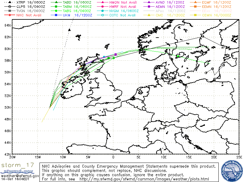
Category 1 Post-Tropical Cyclone Ophelia (2017)
10/15 11:00 PM EDT - Ophelia Now Post-tropical But Still Expected To Bring Strong
Winds To Ireland And The United Kingdom On Monday
49.2N 13.3W
Windspeed: 85 MPH - Pressure: 969mb
Movement: N at 44 MPH
| Public Storm Advisory | Ophelia B C | Dvorak T-Numbers | TAFB ssd UW-CIMSS |
| Governmental Storm Discussion | Ophelia B C | ||
| Forecast Advisory | Ophelia B | ||
The letters B C D and so on stand for alternate information sites, in case one is inoperative during
a internet swamping for storm info you can try another. These advisories come from the National Hurricane center: Usually they
are updated at 5AM, 11AM, 5PM and 11PM eastern.
When land areas are under a hurricane watch, it is updated every 3 hours.
Tropical Tidbits Info Page for Ophelia
- Weather Underground Wundermap
- NHC Interactive Map PlotWhen land areas are under a hurricane watch, it is updated every 3 hours.
Buoy Reports Near Ophelia - CIMSS Data for Ophelia - RAMMB Info and Satellites for Ophelia
Potential Storm Surge Flooding Map (Inundation) - NHC Track Map (See this animated)


 fa
fa
CIMSS Animated Satellite:

Weather Underground Animated Radar:


Coordinate History
| Adv# | Date | Lat | Long | Wind | Pres | Movement | Type | Name | Received | Forecaster |
| 1 | 10/09 5:00 AM | 31.1N | 39.9W | 35MPH | 1008mb | N at 3 MPH | TD | TD#17 | 10/09 4:34 AM | Cangialosi |
| 2 | 10/09 11:00 AM | 31.4N | 39.9W | 40MPH | 1008mb | Nne at 5 MPH | TS | Ophelia | 10/09 10:40 AM | Stewart |
| 3 | 10/09 5:00 PM | 31.5N | 39.6W | 45MPH | 1005mb | Ne at 3 MPH | TS | Ophelia | 10/09 4:40 PM | Stewart |
| 4 | 10/09 11:00 PM | 32.3N | 39.0W | 50MPH | 1002mb | Ne at 7 MPH | TS | Ophelia | 10/09 10:55 PM | Landsea |
| 5 | 10/10 5:00 AM | 31.9N | 38.8W | 50MPH | 1002mb | Se at 3 MPH | TS | Ophelia | 10/10 4:34 AM | Cangialosi |
| 6 | 10/10 11:00 AM | 31.5N | 38.3W | 50MPH | 1002mb | Se at 5 MPH | TS | Ophelia | 10/10 10:55 AM | Stewart |
| 7 | 10/10 5:00 PM | 31.1N | 38.0W | 60MPH | 1001mb | Se at 6 MPH | TS | Ophelia | 10/10 4:40 PM | Stewart |
| 8 | 10/10 11:00 PM | 30.7N | 37.6W | 50MPH | 1002mb | Se at 6 MPH | TS | Ophelia | 10/10 10:37 PM | Brown |
| 9 | 10/11 5:00 AM | 30.2N | 37.0W | 65MPH | 996mb | Se at 6 MPH | TS | Ophelia | 10/11 4:37 AM | Beven |
| 10 | 10/11 11:00 AM | 30.0N | 36.5W | 70MPH | 992mb | E at 3 MPH | TS | Ophelia | 10/11 10:37 AM | Avila |
| 11 | 10/11 5:00 PM | 30.0N | 36.1W | 75MPH | 990mb | E at 3 MPH | H1 | Ophelia | 10/11 4:34 PM | Zelinsky |
| 12 | 10/11 11:00 PM | 30.0N | 35.7W | 85MPH | 986mb | Ne at 3 MPH | H1 | Ophelia | 10/11 10:40 PM | Blake |
| 13 | 10/12 5:00 AM | 30.3N | 35.6W | 85MPH | 986mb | Ne at 3 MPH | H1 | Ophelia | 10/12 4:43 AM | Beven |
| 14 | 10/12 11:00 AM | 30.5N | 35.6W | 90MPH | 978mb | Nne at 2 MPH | H1 | Ophelia | 10/12 10:34 AM | Brennan |
| 15 | 10/12 5:00 PM | 30.4N | 35.5W | 100MPH | 973mb | Stationary | H2 | Ophelia | 10/12 4:40 PM | Zelinsky |
| 16 | 10/12 11:00 PM | 30.7N | 34.7W | 105MPH | 970mb | Ene at 7 MPH | H2 | Ophelia | 10/12 10:49 PM | Blake |
| 17 | 10/13 5:00 AM | 31.1N | 33.9W | 105MPH | 970mb | Ene at 8 MPH | H2 | Ophelia | 10/13 4:52 AM | Berg |
| 18 | 10/13 11:00 AM | 31.8N | 32.9W | 100MPH | 971mb | Ene at 12 MPH | H2 | Ophelia | 10/13 10:36 AM | Brennan |
| 19 | 10/13 5:00 PM | 32.3N | 31.8W | 100MPH | 971mb | Ene at 13 MPH | H2 | Ophelia | 10/13 4:43 PM | Zelinsky |
| 20 | 10/13 11:00 PM | 33.0N | 30.6W | 100MPH | 971mb | Ene at 20 MPH | H2 | Ophelia | 10/13 10:34 PM | Avila |
| 21 | 10/14 5:00 AM | 33.9N | 28.6W | 100MPH | 971mb | Ene at 24 MPH | H2 | Ophelia | 10/14 4:55 AM | Stewart |
| 22 | 10/14 11:00 AM | 34.8N | 26.6W | 115MPH | 960mb | Ne at 25 MPH | H3 | Ophelia | 10/14 10:40 AM | Avila |
| 23 | 10/14 5:00 PM | 35.9N | 23.7W | 115MPH | 960mb | Ne at 28 MPH | H3 | Ophelia | 10/14 4:40 PM | Zelinsky |
| 24 | 10/14 11:00 PM | 37.3N | 21.5W | 115MPH | 960mb | Ne at 28 MPH | H3 | Ophelia | 10/14 10:43 PM | Brown |
| 25 | 10/15 5:00 AM | 39.0N | 18.3W | 105MPH | 964mb | Ne at 35 MPH | H2 | Ophelia | 10/15 4:43 AM | Stewart |
| 26 | 10/15 11:00 AM | 41.6N | 16.0W | 90MPH | 973mb | Nne at 38 MPH | H1 | Ophelia | 10/15 10:46 AM | Avila |
| 27 | 10/15 5:00 PM | 44.6N | 13.3W | 85MPH | 971mb | Nne at 38 MPH | H1 | Ophelia | 10/15 4:46 PM | Zelinsky |
| 28 | 10/15 11:00 PM | 49.2N | 13.3W | 85MPH | 969mb | N at 44 MPH | PTC | Ophelia | 10/15 10:54 PM | Berg |