CFHC Talkback For News Story #118:
Newest Talkback: 02:35 AM 09-30 EDT

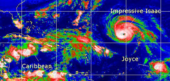
Isaac, Joyce, Caribbean
11:08 PM EDT - 27 September 2000

Tonight, after letting everything gel, we can finally see that Hurricane Isaac has once again strengthened into a major hurricane. Isaac has a very impressive Eye at the moment. The future still finds it a fish spinner, but worth checking out on the loops.

Joyce is a much more compact system and is really prone to rapid strengthening and weakening. It's moving generally toward the west, and some models nudge it a bit southwest for a bit before eventually turning back toward the Northwest. The northeast Caribbean islands will want to watch it. My guestimate still places it near the NW Caribbean islands late weekend. I must note that I do not think it will enter the Caribbean. I wish to note that it is not impossible for it to enter the Caribbean, either. Another possibility is that it gets sheared a bit and stays weak.

The system in the West Caribbean is slowly coming together. I think it has a chance to be another rain event for Florida. It could become a depression tomorrow or the next day. Otherwise, I cannot see it gaining enough strength to become too big a threat. Regardless, the "Tropical Apathy" of the last two storms shouldn't be a factor. Things could change. The remains of Helene, in fact, caused some flooding in Great Britain.

For the moment, Joyce remains the most interesting feature, followed by the Caribbean. For sheer appearance, Isaac also gets high marks.

Issac and Joyce with the Caribbean backup

Comments or Questions? Everyone is invited to use it. Use the comment button by the story Headline.


NRL Monterey Marine Meteorology Division Forecast Track of Active Systems (Good Forecast Track Graphic and Satellite Photos)
Map with nearly all model projected tracks plotted for Isaac. or Joyce From Michael Bryson.
Crown Weather Services Tropical Update (Includes Map with multiple forecast model tracks)
Snonut's Hurricane Reports
Satellite images at: [Visible] (visible -- Daytime Only) [Infrared] (infrared), and [Water Vapor] (water vapor)
Loops: Visible Loop - Infrared Loop - Water Vapor Loop
NASA GHCC Interactive Satellite images at:
[NAtl visible] (visible -- Daytime Only) [NAtl infrared] (infrared), and [NAtl water vapor] (water vapor)--Nasa source.
Ocean Surface Winds Derived from the SeaWinds Scatterometer (Experimental)
StormCarib.com has reports from folks in the Caribbean islands themselves and is worth checking out when storms approach the Caribbean.
Ouragans.com Français -- L'information sur des ouragans comprenant beaucoup de liens.
Tormenta.net Español -- Gran información sobre huracanes aquí.

Some Forecast models: (NGM, AVN, MRF, ECMWF, ETA)
DoD weather models (NOGAPS, AVN, MRF)
AVN, ECMWF, GFDL, NOGAPS, UKMET

- [mac]


Show All Comments

Displaying Talkbacks #1 - #19 (of 19 total)

Interesting Setup.. (#1)
Posted by:
Jim F. (http://flhurricane.com/jfaul/) Location: Ft. Lauderdale
Posted On 06:06AM 28-Sep-2000 with id (RPXNVQNQQTNQVT*)


The models have been advertising carribean development since last saturday with development commencing mid-week and that is exactly what is happening albeit slower(not unusual)than the friendly MRF and other suggested. The models were fairly consistent until yesterday. MRF and AVN want two lows, the carribean low and a low in the bahamas. Others, eta and ngm don't develop the bahamas at all and leave the carribean system weak, seems unlikely as we have some development already with improving environment for development as stated by NHC yesterday and even depression development suggested this morning in the outlook. There is also a building high to the north and that is a sure thing so we know that much. It appears with our building high and low pressure development either south or just east of Sofla or both we are setup for at least breezy conditions with a deep onshore flow which spells rainy/cloudy conditions at minimum. I like a solution of carribean development with minimial bahamas development and eventually the carribean system gets pulled N in 48-72hrs,not NE going south of cuba avoiding florida altogether like John Hope said two days ago, really strong system not likely. Big high to north will help to increase winds no mattter how strong low(s) get.

Joyce-NHC seems confused again in their discussion on a system that was a no-brainer a couple of days ago. I sense to much reliance on the models and waiting again for the noaa jet to give them an easy answer. I predict central to northern islands take a shot and then the system continues to march WNW around high with SE coast starting to look at mid to late next week if recurvature doesn't happen. I don't see any big troughs for the next week so if Joyce can get through the minefield that NHC is suggesting then SE coast better watch out because big high in place keeps system driving WNW.

Isaac-he is like a runway(not runaway)model, great to look at but you(not me)won't ever get close. I predict his partner Joyce will also be really nice to look at shortly.

You can wake up now, my diatribe is over.

Caribbean (#2)
Posted by: StormHound (
http://www.stormhound.homestead.com) Location: O-Town
Posted On 09:22AM 28-Sep-2000 with id (QRNSUNQWNR*)


The models to me seem to be very divergent. Until something more definitive develops, I'm not putting much stock into this system. Joyce, on the other hand, will probably become a big concern for the islands by the weekend, and the U.S. mainland by the middle of next week. Some of the models have Joyce becoming as strong as Isaac.

Navy TC Alert (#3)
Posted by: Gary (
http://†) Location: Hernando Beach fl.
Posted On 10:37AM 28-Sep-2000 with id (RPYNTNTPNQRV*)


WTNT KNGU 281400
1. FORMATION OF A TROPICAL CYCLONE IS POSSIBLE WITHIN 150 NM
EITHER SIDE OF A LINE FROM 16.0N7 83.0W1 TO 19.5N5 87.5W0
WITHIN THE NEXT 12 TO 24 HOURS. AVAILABLE DATA DOES NOT JUSTIFY
ISSUANCE OF NUMBERED TROPICAL CYCLONE WARNINGS AT THIS TIME.
WINDS IN THE AREA ARE ESTIMATED TO BE 15 TO 20 KNOTS.
2. REMARKS: LATEST SATELLITE AND SYNOPTIC DATA INDICATE AN AREA OF
CONVECTION CENTERED NEAR 15.5N1 82.5W5 BECOMING BETTER ORGANIZED.
POTENTIAL FOR DEVELOPMENT IS FAVORABLE WITH A WEAK UPPER LEVEL
RIDGE OVER THE AREA, MINIMAL WIND SHEAR, AND SST'S IN THE LOW TO
MID 80'S. MODEL GUIDANCE SHOWS THIS SYSTEM MOVING SLOWLY NORTHWEST
OVER THE NEXT 24 TO 48 HOURS AS THE SYSTEM BECOMES BETTER ORGANIZED.


Carribean Recon today (#4)
Posted by: Gary (
http://†) Location: Hernando Beach fl.
Posted On 11:18AM 28-Sep-2000 with id (RPYNTNTPNQRV*)


. A RECONNAISSANCE PLANE WILL INVESTIGATE THE AREA
THIS AFTERNOON TO DETERMINE WHETHER A TROPICAL DEPRESSION HAS FORMED


Carribean Development (#5)
Posted by: Mark Ruck Location: Ft Myers Florida
Posted On 12:56PM 28-Sep-2000 with id (QRNWWNQSRNU*)


Hello All,
Latest satellite pictures show a low level circulation near the eastern Honduras coast. If its at the surface will have to wait for the recon flight this afternoon for verification. Because of its position to the coast development will be slow at this time. Now where is it going? At this time not much movement is likely but a nw drift is likely down the road a bit. After that I am not convinced yet but I believe its going to generally head northward in time towards the Yucatan Channel. Thats as far as I will take it. All people in the northwest carribean and southeast Gulf of Mexico should keep tabs on development of this system over the next 72 hours.

T#s up .5 (#6)
Posted by: Gary (
http://†) Location: Hernando Beach fl.
Posted On 03:15PM 28-Sep-2000 with id (RPYNTNTSNQQY*)


28/1745Z 15.2N 82.9W T1.5/1.5


Joyce (#7)
Posted by:
mark
Posted On 03:23PM 28-Sep-2000 with id (RPYNRVNWTNYX*)


latest satt. photos Joyce is strengthning.

Joyce looks good..For now anyways until the ... (#8)
Posted by:
OrlandoDude (http://†) Location: O-Town
Posted On 03:40PM 28-Sep-2000 with id (RPYNRQYNRPYNVX*)


Dynagel gets sprinkled in her path...LOL..... Sounds to me like people have been watching Conspiracy Theory one to many times...

Sorry I couldnt resist.. Anyways, I think the islands should get themselves prepared...


Caribbean recon report (#9)
Posted by:
Frank Location: Biloxi MS
Posted On 04:36PM 28-Sep-2000 with id (QRNQSNRTXNS*)


http://www.nhc.noaa.gov/text/MIAREPNT2.html


TD 15... (#10)
Posted by: Bill Location: TLH
Posted On 04:43PM 28-Sep-2000 with id (RPTNQQPNRQTNYT*)


has formed in the Carib off Honduras, 30 kts, 1004 mb...has deepened quite a bit today.

IHS,

Bill

Active (#11)
Posted by:
Darcy (http://www.dynagel.com)
Posted On 04:58PM 28-Sep-2000 with id (RPVNTXNQRSNRP*)


We now have our strongest, largest, and best-looking/ best-defined tropical cyclone of the season.
Issac has 140mph winds now.
Beauty!

I'm going to go check TD 15!


activity rush (#12)
Posted by: Frank Location: Tallahassee
Posted On 05:34PM 28-Sep-2000 with id (QRXNQXVNQRSNSW*)


see, this season has been waiting timidly all along. the shear monster finally took some time off in late september, as opposed to late august. isaac looks every bit of awesome, and is making up for lack of threat by sheer intensity. joyce is tumbling wsw, looking chaotic but forecast by intensity models to be pushing major hurricane status when approaching barbados late sunday. td 15.. what can i say? 72 hour forecast makes hurricane keith out of it, keeps it in a very threatening position. hurricane season has finally arrived, almost into october.
we could have a gulf storm menacing and also something ripping across the caribbean.. and maybe looming off the east coast by this time next week.
have a good one cfhc, sure to be a busy site.

Hugo 89' or Georges 98' ? (#13)
Posted by:
R.A.D (http://flhurricane.com/rad) Location: St Petersburg, Florida
Posted On 05:37PM 28-Sep-2000 with id (RTNRXNRNSY*)


http://files.hurricanealley.net/images/14lhist.jpg

Re R.A.D. (#14)
Posted by: JJ
Posted On 06:07PM 28-Sep-2000 with id (QRYNQQUNRSUNQUU*)


Those maps aren't more than a curiosity piece--none of them take the time of year into account. Hugo and Georges formed earlier in the month, and in any case, were powerful hurricanes by the time they were near Joyce's current position.

JJ (#15)
Posted by: StormHound (
http://www.stormhound.homestead.com/) Location: O-Town
Posted On 07:09PM 28-Sep-2000 with id (VSNRURNVWNQW*)


Not to be picky, but the composite does show that these are ones + or - 15 days. So, I guess it does take time of year into account.

test (#16)
Posted by:
Mike (http://flhurricane.com) Location: Newport News, VA (Currently)
Posted On 10:26PM 29-Sep-2000 with id (RTNRNUSNVY*)


test

test (#17)
Posted by:
Mike (http://flhurricane.com) Location: Newport News, VA (Currently)
Posted On 10:27PM 29-Sep-2000 with id (RTNRNUSNVY*)


test2

test (#18)
Posted by:
Mike C. (http://flhurricane.com) Location: Newport News, VA (Currently)
Posted On 10:33PM 29-Sep-2000 with id (RTNRNUSNVY*)


test 2

test (#19)
Posted by:
Mike C. (http://flhurricane.com) Location: Newport News, VA (Currently)
Posted On 10:35PM 29-Sep-2000 with id (RTNRNUSNVY*)


test 3


Show All Comments


Return to Central Florida Hurricane Center Main Page