CFHC Talkback For News Story #146:
Newest Talkback: 06:20 PM 11-03 EDT

Southwest Caribbean
07:51 AM EST - 29 October 2000

Right now the only thing worth watching is in the Southwestern Caribbean Sea. There is a persistant area that may want to form over the next few days. Folks along the coast in that area should be watching in case something does form. If it does, I don't expect anything major.

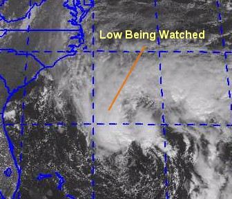
The low in the Atlantic has moved up and out without forming into anything tropical.

Today was the day you should have set your clocks back an hour. If you forgot, do it now.

Tropical, Subtropical, Non-Tropical... place your bets.

Comments or Questions? Everyone is invited to use it. Use the comment button by the story Headline.


NRL Monterey Marine Meteorology Division Forecast Track of Active Systems (Good Forecast Track Graphic and Satellite Photos)
Crown Weather Services Tropical Update (Includes Map with multiple forecast model tracks)
Snonut's Hurricane Reports
Other commentary at: Mike Anderson's East Coast Tropical Weather Center - Stormwarn2000 - SCOTTSVB's Hurricane Update Center - Jim Williams' Hurricane City - Gary Gray's Millennium Weather - Even More on our Links Page
Satellite images at: [Visible] (visible -- Daytime Only) [Infrared] (infrared), and [Water Vapor] (water vapor)
Loops: Visible Loop - Infrared Loop - Water Vapor Loop
NASA GHCC Interactive Satellite images at:
[NAtl visible] (visible -- Daytime Only) [NAtl infrared] (infrared), and [NAtl water vapor] (water vapor)--Nasa source.
Defiant Visible Infrared More...
Ocean Surface Winds Derived from the SeaWinds Scatterometer (Experimental)
Tormenta.net Español -- Gran información sobre huracanes aquí.

Some Forecast models: (NGM, AVN, MRF, ECMWF, ETA)
DoD weather models (NOGAPS, AVN, MRF)
AVN, ECMWF, GFDL, NOGAPS, UKMET

- [mac]


Show All Comments

Displaying Talkbacks #1 - #5 (of 5 total)

SW Carib (#1)
Posted by: Steve H.
Posted On 09:23AM 29-Oct-2000 with id (RPUNQXXNQYWNTW*)


The area of convection north of Panama is getting better organized now, and it wouldn't surprise me if a depression forms there in the next day. Haven't seen any models yet, but I believe there is hijgh pressure to the NW of that area. Unless this high breaks down, this system will probably end up moving into the Nicaraguan coast. Anyone have any data on this ? Looks pretty impressive right now. Cheers!!

MESSAGE BOARDS (#2)
Posted by:
LONNY Location: HOLLYWOOD,FL
Posted On 12:09PM 31-Oct-2000 with id (RPUNQXXNQYUNRT*)


Now that we are coming to the end of 2000 tropical season I'd like to say thanks to this board because it has been the most useful source of information for me. The weather channel was the worst. It was down when needed and changed format one too many times. I look forward to the 2001 tropical season and all the responses on this board. Thanks and have a great winter.


eastpac/lull (#3)
Posted by: HankFrank Location: Tallytown
Posted On 08:28PM 31-Oct-2000 with id (QRXNQXVNQRSNSW*)


that sw carib disturbance has shifted westward, now its mostly south of costa rica. yesterday's gfdl was developing it OVER nicaragua and moving it up to the coast of el salvador.. most of the convection around there is just below 10n, but if something does stir it would have an interesting path. that area is climatologically.. well, nothing ever forms down there. i give it one in ten, who says it cant break the rules.
lonny's talk about the season being over.. may be right. ever since that low moved up the coast that week practically all of the north atlantic basin is sheared too badly for anything to come together. unless the shear relaxes somewhere again, the season is done for. i was betting on 15, too.

carribean convection (#4)
Posted by: Alex
Posted On 05:23PM 01-Nov-2000 with id (RPVNRQPNRQTNS*)


it looks like the convection is becoming beter organized. Is a low forming? Please comment

nothing doing (#5)
Posted by: HankFrank Location: Tallytown
Posted On 01:20PM 03-Nov-2000 with id (QRXNQXVNQRSNSW*)


thats for the atlantic. that eastpac disturbance is changing very slowly, but getting better organized. really i dont know why they dont have it classified right now, it has a clear low level structure and has to be tropical in nature. dont see anything happening in the atlantic in the near future.


Show All Comments


Return to Central Florida Hurricane Center Main Page