CFHC Talkback For News Story #36:
Newest Talkback: 10:32 PM 08-05 EDT

Alberto and More
08:56 AM EDT - 05 August 2000

Alberto has held its own overnight, and is a little shy of Hurricane Status now, with more slow strengthening in the future. (It may wane a bit before picking up again as well)

Is Alberto Familiar? The name "Alberto" was last used in 1994, and back then it was a Tropical Storm which caused extreme flooding in Southern Georgia. 30 people died in the floods there. It never got stronger than a Tropical Storm, but it stagnated over the state. Alberto, nonetheless, was not retired, so the name comes back again, but this time as a Cape Verde storm.

It's distance still gives us many days to watch it. And the future path suggests that the Caribbean Islands should keep watch of it for now. It's much to early to say if they will be impacted or not, much less us in the US. The forecast models predict a slight northward drift over time, but the general westward movement will continue. It may even head more of a due west later on.

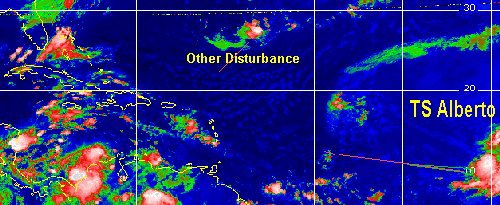
Another system Southeast of Bermuda still is trying to hold on, and if it continues to persist and continues moving in a Southwestward direction could form. We'll have to watch this too, as it is much closer than Alberto is.

We'll keep up the watch.
Dr. Gray and the rest at Colorado State University has reduced predictions by one in named storms, hurricanes, and major hurricanes. Announced on the same day that Alberto formed.

Alberto in the East

What is your opinion on this wave? Comments? Use the comment button by the story Headline.

Nice Satellite Image of Atlantic (IR Colorized)

Satellite images at: [N.A. visible] (visible -- Daytime Only) [N.A. infrared] (infrared), and [N.A. water vapor] (water vapor)--Nasa source.

Some Forecast models: (NGM, AVN, MRF, ECMWF, ETA)
DoD weather models (NOGAPS, AVN, MRF)

- [mac]


Show All Comments

Displaying Talkbacks #1 - #10 (of 10 total)

ALBERTO MAY BECOME HURRICANE TODAY (#1)
Posted by: Mike Anderson (
http://www.angelfire.com/fl4/eastcoasttropicalwea/ectwp.htm) Location: Miami FL
Posted On 09:21AM 05-Aug-2000 with id (QURNQVSNRPWNUT*)


Alberto has shown signs of getting much better organized this morning with a 5 MB drop in pressure to me this suggests we are looking at Hurricane Alberto but as I noted on my own site this morning I will wait for the official word on that, but would not be surprised to see the next advisory on the system upgraded. The track seems to be more west after what I believe was a relocation of the center last night due to the rapid intensification on Friday. A rather strong ridge of high pressure to the North of the cyclone should remain in place keeping Alberto well south of 20 through 72 H. Last night I ran our model ECTWP which is a new feature we added to East Coast Tropical Weather Center on Alberto, I have to say this new Model which I have been working on the last 4 years has done very well in trial runs and showed no different last night being ahead of some of the more famos models used at NHC. If any of you are interested in viewing this model here is the link to the site. To Mike and John C. I'm real happy you are back up and running and I wish you the best this season let's keep in touch.
Mike
www.angelfire.com/fl4/eastcoasttropicalwea/ectwp.htm

We got Alberto, could Beryl be on the way? (#2)
Posted by:
Richard B (http://www.atlantic-technologies.co.uk) Location: Gloucester, England, UK
Posted On 09:35AM 05-Aug-2000 with id (RQRNQSYNQXPNRQQ*)


In line with Mike above i think it is possible that Alberto will be upgraded to a hurricane today. However it looks set to move over slightly cooler waters in the short term. This will slow any strengthening of the system down a little. It looks very good on both visible and IR imagery, with a great circulation. And has anyone noticed how compact he is? Reminds me a little of that famous '92 Hurricane... Andrew. I still think interest in the Caribbean may need to watch this system, but i also get a feeling that the Bahams may need to watch out for this storm in a few days.
And my old favourite, the Low southeast of Bermuda, is still here! As i said earlier wind shear is the main factor inhibiting this storms development, with the convection being displaced some 75nmi from the LLCC. However this shear is forecast to decrease as the storm moves in a southwestward direction... and i still think we may see a tropical or sub-tropical depression form from this low within the next day or two. Convection continues within this system, and once the shear lets up this system may well flare up, being over good water temperatures. I will continue to watch this system very closely over the next 24-48 hours as it poses more of a threat to land than Alberto does... perhaps we will have Beryl in the Bahamas before Alberto. We will have to wait and see.

Beryl? (#3)
Posted by: Steve H. Location: Palm Bay Fl
Posted On 10:34AM 05-Aug-2000 with id (RPUNQXXNQYVNUQ*)


Richard, please keep us posted on this system, as I am having trouble getting sat loops on my computer. Is there a circulation with this system? Hard to tell without a loop, but I keep seeing convection firing on and off. What is the current prognosis of this system in your opinion? Will it move southwestward towards the Bahamas & Fl? Interested since i'm in the Cape Canaveral area You probably don't know where Palm BAy is....really about 50 miles SSW of the Cape near Melbourne. cheers!

Mike (#4)
Posted by:
Mike Cornelius (http://www.flhurricane.com) Location: Newport News, VA
Posted On 11:06AM 05-Aug-2000 with id (RTNRWNRRTNSR*)


Nice job with the model Mike. This season at some bit of expense we have are own hardware and our own colocated link. We aren't repeating last year.

I just fixed a few bugs with the code, and when you post to here your names will stick so you won't have to retype everything again.

If anyone who is qualified wants to have access to post main page stories, let me know. Or just continue to post here. It's some great commentary.

- Mike

The pressure is going the wrong way! (#5)
Posted by:
Richard B (http://www.atlantic-technologies.co.uk) Location: Gloucester, England, UK
Posted On 11:27AM 05-Aug-2000 with id (RQRNQSYNSTNVP*)


Well after intensification since developing Alberto is now weakening. The minimum central pressure is up from 994mb to 1000mb.. mainly due to the systems progress over cooler waters as i predicted earlier. NHC now say we will have to wait upto 72 hours before Alberto reaches hurricane strength. This is mainly due to the fact that Alberto will remain over marginal SST's for upto another 48-60 hours, before the forecast westward motion brings him back over warmer water. He remains a compact system to!
And even though the Low to the southeast of Bermuda has weakened i still hold out that it may develop. Minimum pressure is around 1020mb, but continuing wind shear is tearing the convection from the low level circulation, in fact the convection is being dragged upto 75nmi from the low centre! The convection is not as strong as it has been. Despite this it persists, and with the forecast drifting to the southwest this low will enter a more favourable environment, with wind shear gradually decreasing. I will continue to watch this system with interest as should persons in the Bahamas.
I hope this answers your questions Steve... there is a low level circulation, and i still think the Bahamas should watch the area, but i cant really say for Florida as it is too early. I will keep ya posted.

ALBERTO UP IN SHORT TERM ONLY (#6)
Posted by: Mike (
http://www.angelfire.com/fl4/eastcoasttropicalwea/ectwp.htm)
Posted On 01:15PM 05-Aug-2000 with id (RPUNQXXNQYVNRY*)


Alberto seems to have run himself into some cooler sea surface temperatures however this is only short term, As expected a rather large ridge of high pressure is forecast to build north of the system thus turning Alberto back to a more westerly component. I expect some marked strengthening at 36 H. The system Richard is referring to does look as if shear is tearing it apart however with the Bermuda high expected to build along the East coast Sunday night I would expect to see a return to the heavy convection we saw yesterday, for now any development would be very slow to occur. Richard I enjoy your posting in this site, I would like to extend you an invite to East Coast Tropical Weather Center, there we also have a message board and a live chat, tonight we are chatting at 7:00 if you like you are welcome to join would be nice to share your thoughts on both systems, as well all others on this board are welcome to the chat tonight. Mike

On the Rebound Again (#7)
Posted by: Steve H.
Posted On 02:19PM 05-Aug-2000 with id (QURNQVSNRQSNUT*)


Alberto's been up and down....and I guess that's what we'll have to expect today. But looking at the satellite loops from NRL, looks like he's trying to develop an eye, and relly looks due west in the last 6 frames....don't let the 1715 frame fool you...the overlay is messed up. He's one to watch...but we'll have a week to do it. Other than that, the last pix I saw looks like the area se of Bermuda is showing some life again, and as Mike said, the Anticyclone building to it's north will give it better conditions to work with (actually control it). Scottsvb noted that a low has formed in Nicaragua and is headed NW toward the Yucatan, then the gulf...we'll see how that develops..convection is organizing there as well. My pet wave continues to chug to about 48W, 18N now, and should come under the favorable environment of the ridge as well. Cheers! PS: Richard - thanks for the reply - and chat tonight at the East Coast Tropical Weather center!

Head West Young Man (#8)
Posted by: Steve H.
Posted On 03:55PM 05-Aug-2000 with id (QURNQVSNQYWNWX*)


Yes, it looks like Aberto is taking that west heading and may be at Hurricane staus as of 3:45 EST (at least that's what the sat pix tell me) Not Official. But the banding features look good, and good outflow has reestablished itself. Hard to tell exactly, but it appears it is moving almost due west now, and may be beginning to respond to the high to it's north. I expect the winds will be up in the next advisory, maybe at Cat 1. Cheers!

Alberto (#9)
Posted by:
Rick Shade Location: Mobile, Al
Posted On 04:31PM 05-Aug-2000 with id (RPUNQXXNQYWNSS*)


Well, activity was slow getting out of the gate this year...Mr Gray may have changed his forecast too soon....anyway..I think the system in the southern Caribbean deserves watching. One model suggests it may well drift into the Yucatan over the next three or four days....I remember Opal stalled there, and quickly built to a category 4-5, drifting north and hitting Pensacola.....real close to home.

For the Cape Verde storms...the path the last 5-6 years has been a curve away from the Gulf.....we Mobilians realize this pattern can change. I wonder if this year any of them will make it into the gulf...maybe slam through Florida like Andrew did. Something else too. The stronger storms...tend to head like a snowball downhill....and steering currents tend to have little effect on them. Gilbert and Andrew, as I recall...at first went dead on a nearly straight path...plus, I read somewhere where they get so strong...they hold a pressure ridge and outflow on top of themselves....and little can affect them. Anyway...anyone out there that cares to refute this...please do..I am quite a novice...but willing to learn...


From a wave to a hurricane in less than 48 hours! (#10)
Posted by:
Richard B (http://www.atlantic-technologies.co.uk) Location: Gloucester, England, UK
Posted On 06:32PM 05-Aug-2000 with id (RQRNQSYNQXRNVP*)


Well he has made it! Alberto has reached hurricane strength with an eye becoming evident on visible imagery. The storm is still compact and is not expected to intensify until over warmer SST's in about 36-48 hours, however NHC said he would not reach hurricane strength for another 48-60 hours earlier today! How quickly things change.
And i am STILL watching the area of disturbed weather southeast of bermuda. Convection contiunes to fluctuate around the low, despite being torn by vertical windshear. And i do feel that we must keep watching this area as it enters a more favourable environment within the next day or two. Wind shear should decrease and with the circulation already in place and convection flaring up it may not take long to develop... who knows!
And something that has caught my eye this evening is the disturbed weather in the western Caribbean, it appears to be organising nicely. I see that there is evidence of a curvature in both visible and satellite imagery, and convection is increasing with a few areas reaching the red colours on ir imagery, mainly in the southern part of the disturbed area. I think we shouls watch this closely too, it may develop and a few models take a low over the Yucatan and into the Gulf within 48-72 hours. Looks like activity is really picking up!


Show All Comments


Return to Central Florida Hurricane Center Main Page