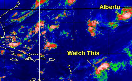
CFHC Talkback For News Story #55:
Newest Talkback: 04:16 AM 08-18 EDT

Heads up Caribbean
11:47 AM EDT - 17 August 2000

The system east of the Lesser Antilles islands (East of the Caribbean) is looking very good today.
My Development Chances Scale for this wave:

(forget it) 0 1 2 3 4 5 6 7 8 9 10 (sure thing)
           [------------------*---]
This system is very likely to affect some of the Caribbean, and at unknown strength right now. We'll be watching.

Alberto is still around, but otherwise not much is going on beyond these two things. (East Atlantic isn't looking too well)
TD#6 Canidate

Comments or Questions? Use the comment button by the story Headline.


StormCarib.com has reports from folks in the Caribbean islands themselves and is worth checking out when storms approach the Caribbean.
Nice Satellite Image of Atlantic (IR Colorized)

Satellite images at: [N.A. visible] (visible -- Daytime Only) [N.A. infrared] (infrared), and [N.A. water vapor] (water vapor)--Nasa source.

Some Forecast models: (NGM, AVN, MRF, ECMWF, ETA)
DoD weather models (NOGAPS, AVN, MRF)
AVN, ECMWF, GFDL, NOGAPS, UKMET

- [mac]


Show All Comments

Displaying Talkbacks #1 - #19 (of 19 total)

Tropical Development (#1)
Posted by: Mark Ruck Location: Ft Myers Florida
Posted On 12:02PM 17-Aug-2000 with id (QRNWWNQTUNQWW*)


Hello All,
Well this wave is on the edge of becomming a Tropical Depression. There is signs of wind shear over the southeastern half of the wave with winds between 20-25 knots. Over the northwestern half it drops to around 10 knots. This is why thunderstorms are developing over the northeastern half right now. As this system moves westward it should have a better chance to become a TD maybe as early as late today but most likely tommorow. A recon flight is scheduled for tommorow afternoon. All people from the Dominican Republic to the eastern islands of the carribean need to watch very closely for development. Beyond this it may turn more north due to a large trough off the eastern seaboard but this also is forecastyed to start to break down beyond 48 hours and if this holds true this could be a problem for the southeast U.S. down the road but its too early to tell yet.


Chris??? (#2)
Posted by:
Richard Byett (http://www.atlantic-technologies.co.uk) Location: Gloucester, England, UK
Posted On 12:29PM 17-Aug-2000 with id (RQRNQSYNQXUNQXV*)


Well the wave that is east of the Caribbean does indeed seem to be getting better organised, and NHC are saying it may become a Tropical Depression at any time. Based on Satellite imagery, and this comment by NHC, i have issued a 'Tropical Cyclone Formation Alert' from my site. This system does indeed appear to be under some shear, with the strongest convection in the northern semicircle. However the visible imagery shows a definite circulation with strong banding features around the systems centre.
As for where it may go..... well initially folks in the western and northern Caribbean might want to monitor this system closely. However after that i am uncertain. It may turn north towards the Bahamas and the SE US, but this is just a guess at best.
And Alberto is still keeping us company... with the forecast taking him back to hurricane strength in 48 hours. It will be interesting to see where he goes next too!


A Question (#3)
Posted by:
Colleen Location: Lakeland, Florida
Posted On 12:33PM 17-Aug-2000 with id (QURNQVSNRPQNRPQ*)


I have a question in reference to the Recon Flight being rescheduled until tomorrow: is this because they believe this will be a TD/TS within the next 24 hours (or less) because of the visible pictures available to them? So they want to wait until tomorrow to save money? Just curious as to the reasoning of this ...thanks...Colleen

RECON (#4)
Posted by: Thomas Location: Houston, TX
Posted On 12:45PM 17-Aug-2000 with id (QVYNQSRNQSWNQQU*)


It has more to do with positioning the aircraft than saving money. It is a long flight in a C130 from Biloxi, Ms to the islands and then another 600 miles or so to the suspect area. The aircraft will leave Biloxi today and fly to the Carribean and then be ready to fly the area tommorow morning. If the system would have been between Mississippi and their destination the probably would have flown through on the way.

Thanks, Thomas! (#5)
Posted by:
Colleen Location: Lakeland, Florida
Posted On 01:01PM 17-Aug-2000 with id (VTNQRNQPUNQXR*)


Thanks for your insight!!! I read this on the IWIN/NWS early morning report from Tallahassee:

EXTENDED: WITH LONG RANGE GUIDANCE ADVERTIZING FRONTAL BOUNDARY SLIDING INTO THE FORECAST AREA AND ORIENTED E-W EXPECT INCREASING
PRCIPITATION TO NUMEROUS SUNDAY AND MONDAY. IF UPPER AND LOWER DYNAMIC PLAY AS ADVERTIZED. SEVERE WEATHER A DISTINCT POSSIBILITY.

Are they talking about the Bahamas area or are they talking about this system? I highly doubt it would take 6 days for the Bahamas disturbance to reach us...any thoughts?? (sorry I ask so many darn questions!!!) Colleen


Colleen (#6)
Posted by:
Richard Byett (http://www.atlantic-technologies.co.uk) Location: Gloucester, England, UK
Posted On 01:09PM 17-Aug-2000 with id (RQRNQSYNQWRNXS*)


In answer to your question Collen it may be possible that they are on about the disturbance east of the lesser Antilles. The models place it to the southeast of the Bahamas in 72 hours (or by Sunday morning). Therefore it may be they are recognising the possibiltiy this system may affect the SE US. By the 72 hour period the large trough off the east coast is expected to have broken down, therefore this system may be on a heading for the South East. This is only my guess but it is the only conclusion i can come to at the moment.

Richard, Thank You (#7)
Posted by:
Colleen Location: Lakeland, Florida
Posted On 01:13PM 17-Aug-2000 with id (VTNQRNQPUNQXR*)


That was my thinking, however, since I am not a weather expert, I didn't want to guess. This website is great, and I appreciate the way everyone helps everyone else out. Thanks again...with the Tropical Cyclone Alert issued this morning stating "a significant tropical cyclone may be developing", I kind of figured this is what they may be referring to...Colleen

Richard, Thank You (#8)
Posted by:
Colleen Location: Lakeland, Florida
Posted On 01:15PM 17-Aug-2000 with id (VTNQRNQPUNQXR*)


That was my thinking, however, since I am not a weather expert, I didn't want to guess. This website is great, and I appreciate the way everyone helps everyone else out. Thanks again...with the Tropical Cyclone Alert issued this morning stating "a significant tropical cyclone may be developing", I kind of figured this is what they may be referring to...Colleen

Tallahassee Report (#9)
Posted by: clyde w. Location: orlando
Posted On 01:39PM 17-Aug-2000 with id (VSNWSNRQSNU*)


Colleen,

I don't think the severe weather possibility noted by the Tallahassee NWS refers to the tropical system east of the Lesser Antilles. My reasoning is that they are talking about Sunday night/Monday morning, which would be only about 4 days away from the time the discussion was posted. It's pretty unlikely that the system would move into the Gulf that quickly. More likely they are talking about a frontal convergence and seabreeze interaction with the cold front causing severe thunderstorms to fire. I read the rest of the NWS Florida discussions and none of them mention the system east of the Lesser Antilles, and usually Ruskin and Melbourne are the first to speak up about an approaching system.

Happy Tracking,
Clyde

NWS IWIN REPORT (#10)
Posted by: Bill Location: Tallahassee
Posted On 03:16PM 17-Aug-2000 with id (RPTNQQPNRQQNRTW*)


Colleen and all-

this report DOES NOT refer to tropical weather of any sort, but the front, seabreeze, and upper jet dynamics of the area as expected at that time.

IHS,

BIll


Thanks for Clearing that up!! (#11)
Posted by:
Colleen Location: Lakeland, Florida
Posted On 03:40PM 17-Aug-2000 with id (QURNQVSNRPWNTV*)


Thanks for clearing that up....now, on to the tropical wave..why is it that the NHC will NOT issue a TD status for this wave when it so obviously much better organized than Beryl EVER was? This makes no sense to me whatsoever. So it is lacking thunderstorms around the center and that is not why? With Beryl it was hard to even FIND the circulation center and they STILL issued it as td#5 and then TS status. Doesn't make any sense to me. But then again, this whole season hasn't made any sense so far....

Beryl vs. Wave (#12)
Posted by: clyde w. Location: orlando
Posted On 03:54PM 17-Aug-2000 with id (VSNWSNRQSNU*)


Colleen,

I think in many instances, location is a big determining factor. For example, with Beryl being located in the Gulf, a plane was sent in and picked up tropical storm force winds. So, despite the disorganization that the system showed, it was clear that the storm did contain winds that made it a tropical storm.

With the system in the Atlantic, a plane has not yet investigated, so forecasters rely on other observations, such as satellite photos, ship reports, and floating bouys. It is possible that despite its appearance, there have been no ship reports in the area showing pressure falls or strong winds, therefore, no TD.

This works both ways. Last year, forecasters were certain that a small swirl in the same general location was just a disturbance, but a recon plane reported 55kt winds the next day and Tropical Storm Emily was named. In most cases however, it seems that a reliable ship report leads to the naming of TD's in the eastern and central Atlantic, though not always.

Emily last year? (#13)
Posted by: Robert
Posted On 04:02PM 17-Aug-2000 with id (QYYNRRWNQWSNRX*)


With emily last year with 55knt winds ant td#4 this year, it makes you think how many other little swirls or disturbances have been depressions or storms without being classified or named?

Good Point (#14)
Posted by: clyde w. Location: orlando
Posted On 04:20PM 17-Aug-2000 with id (VSNWSNRQSNU*)


I have often wondered that, as well as what the average number of storms annually would actually be if we had had satellites over the past 100 years. Dr. Gray has said in his estimates that he includes 1 or 2 storms each year above his statistical scheme based on those storms that would have gone unnoticed in years past for lack of satellite coverage.

Wave east of Lesser Antilles (#15)
Posted by:
Richard Byett (http://www.atlantic-technologies.co.uk) Location: Gloucester, England, UK
Posted On 04:31PM 17-Aug-2000 with id (RQRNQSYNSTNSP*)


Has anyone noticed how the 'wave' that we are all talking about seems to have an 'eye' like feature on both the latest visible and ir satellite imagery? It still has me wondering how on earth this thing has not been upgraded yet? Surely NHC can make some sort of estimate just based on satellite imagery. To me this thing has to be at least a TD and it would not surprise me if the Recon Flight tomoro comes back and this wave is then declared Chris.
Just looking at the imagery it is one of the best organised system we have seen so far this year, better than Beryl, and better than that halfpenny sized TD#4! Who know perhaps it wont be declared a TD at all, perhaps it will go straight in as a TS. Either way this definitely does not look like a wave to me, and i firmly beleive we will see it become Chris. If you live in the Caribbean you really should start monitoring this system very closely! It seems like it might flare up quickly!


Look for the 5PM Update (#16)
Posted by:
Colleen Location: Lakeland, Florida
Posted On 04:47PM 17-Aug-2000 with id (VTNQRNQPUNQVS*)


Watch...it will happen. They will upgrade it.

TD #6 (#17)
Posted by: Joe
Posted On 05:02PM 17-Aug-2000 with id (RQVNSNQXRNQSQ*)


Its located at Lat-14.9 Lon-53.5.Winds are at 35 MPH.The Pressure-1010mb.Movement towards the WNW
at 12 MPH.This will most likely become Chris by
Tomorrow.

unnamed swirls (#18)
Posted by:
troy Location: titusville,fl
Posted On 05:39PM 17-Aug-2000 with id (VSNRTNXXNQQP*)


i have often noticed swirls or area of circulation east of bermuda and allways wrote them off as upper or mid level lows. a few years back i was happily surprised when the nhc actually classified one of these as a hurricane no less. does anybody know what storm this was...was in 98 or 97 and formed close to the azores....
troy

wave east of td 6 (#19)
Posted by: david
Posted On 12:16AM 18-Aug-2000 with id (RPYNRVNWTNQW*)


this wave has much more potential to affect carribean and u.s. much more to south than others this year. heard today computer models show it to be hurricane. and threat to u.s. next week.


Show All Comments


Return to Central Florida Hurricane Center Main Page