CFHC Talkback For News Story #68:
Newest Talkback: 12:38 PM 08-23 EDT

Hurricane Debby North of Puerto Rico
02:32 PM EDT - 22 August 2000

11PM Update:
Debby continues its just slightly north of due west motion, and the longer this holds the worse this means for South Florida. The Gulf of Mexico track can't be ruled out yet either. More or less my previous thinking remains the same. The intensity of Debby when it approaches is conservatively estimated around a Category 3 storm -- * the potential is there for stronger *.

Tomorrow I would not be surprised to see the Florida Keys start to take some action (like suggesting tourists leave), not because they think it will go there, but rather because of the long time it would take to evacuate if it did.

Highest Risk Zone still lies between Miami and West Palm Beach, FL. Very subject to change, see you tomorrow.

PLEASE FOLLOW the advice from local authorities. Folks in Florida will have time to prepare between now and Friday. So have a plan ready if the storm decides to head your way. Use official sources and local media for more information.

9PM Update:
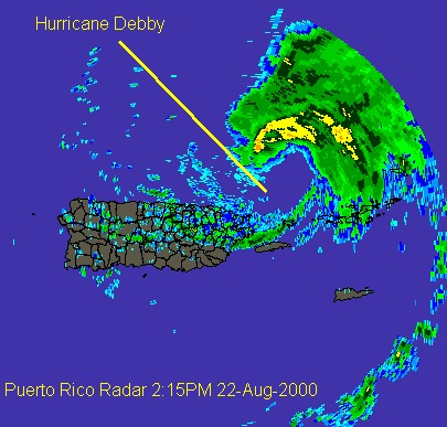
Debby has gone from a West NW motion to more of a general westward motion at this hour, which is plain to see on the Puerto Rico radar image. (Debby is beginning to move out of range of this radar) It's maintaining the 75MPH windspeed and probably will until tomorrow. The forward motion has slowed a bit to 18MPH.

Jim Williams over at
Hurricane City is doing an audio broadcast now until 11PM tonight.

Original Update:
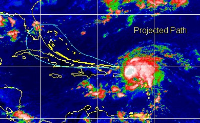
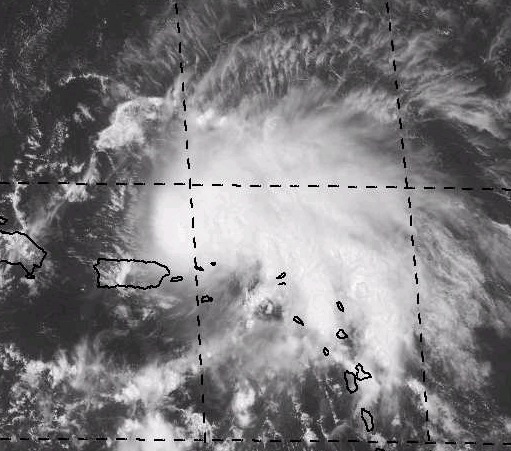
As these series of images show, Hurricane Debby is now skirting along the northern coast of Puerto Rico. Luckilly for them, most all of the convection is on the Northeast side. It is starting to wrap around, though, which would indicate it trying to become better organized.

The future track is leaning away from the Gulf scenario (can't count it out yet, though) and more toward the South Florida northward scenario. Basically what was said earlier today on the page. We will continue to watch it.

Debby Radar Image
Debby Visible Closeup
Debby Track

There will be no organized chat event tonight, but we hope to do one tomorrow night. Jim Williams over at Hurricane City will be doing another broadcast tonight at 8PM. Worth a listen.

Comments or Questions? Everyone is invited to use it. Use the comment button by the story Headline.
NRL Monterey Marine Meteorology Division Forecast Track of Debby (Good Forecast Track Graphic)

StormCarib.com has reports from folks in the Caribbean islands themselves and is worth checking out when storms approach the Caribbean.
Ouragans.com Français -- L'information sur des ouragans comprenant beaucoup de liens.
Tormenta.net Español -- Gran información sobre huracanes aquí.

Crown Weather Services Tropical Update (Includes Map with multiple forecast model tracks)
Snonut's Hurricane Reports
Weathervine Storm Intercept Team's Audio and Video broadcasts
Live Webcam image from Florida Emergency Management's Emergency Operations Center
Florida Emergency Management Activation Page / Situation Updates
Nice Satellite Image of Atlantic (IR Colorized)

Satellite images at: [N.A. visible] (visible -- Daytime Only) [N.A. infrared] (infrared), and [N.A. water vapor] (water vapor)--Nasa source.

Some Forecast models: (NGM, AVN, MRF, ECMWF, ETA)
DoD weather models (NOGAPS, AVN, MRF)
AVN, ECMWF, GFDL, NOGAPS, UKMET

- [mac]


Show All Comments | Show Previous 39 Comments

Displaying Talkbacks #21 - #41 (of 41 total)

educated guess (#21)
Posted by: Brian Location: Hollywood, Florida
Posted On 06:55PM 22-Aug-2000 with id (QSWNURNRPPNV*)


From the information imparted to the public from Jerry Jerrel, it seems the high pressure ridge to the NE of Debby is going to weaken in 48 hours. At the same time, the trough MAY be too weak to lift Debby, but rather, it MAY "nudge" it northerly, and then return to a more westerly track. Remember, no one, not even Max, will have a clue until late tomorrow, or even Thursday. Hope that helps. My suggestion, check how cold the temps are projected to get in Tenn, KY, NC, SC, and GA, this will give you an idea as to the strength of the trough projected to move south on Friday.

radar (#22)
Posted by: jimmy
Posted On 07:57PM 22-Aug-2000 with id (RQVNWWNQUWNR*)


the last few frames on the radar show a tightening eye and a westward jog. I know I have said this before, but it looks like it is getting its act together and is slowing just a bit. I am no meteorologist, but something tells me this storm will be stronger than anticipated and will stay more westerly than expected based on the few forecast models I have seen. Also, Debby makes the Gulf, this could be one for the ages. Just a guess.

Former directors' comments (#23)
Posted by: Cal
Posted On 08:13PM 22-Aug-2000 with id (VSNRUTNQRRNQVY*)


Does anyone else notice that these former NHC directors' comments always have the storm headed for their TV markets? I think they do that to keep their local viewers tuned into their station.

Watches (#24)
Posted by: Richie Location: Boynton Beach
Posted On 08:14PM 22-Aug-2000 with id (QURNQVSNRPQNUT*)


According to Max Mayfield on the 6 o'clock news, no watches for Florida will be issued until Wed.eve. or Thurs. a.m. because the storm is expected to slow.

TV markets.... (#25)
Posted by: Rick Shade Location: Mobile
Posted On 08:52PM 22-Aug-2000 with id (RPUNQXXNQYSNQUV*)


I concur...with the idea that those most affected tend to lean the storm their way. This is definitely going to get even more interesting. As I have wondered.......when the next Cape Verde storm misses everything in her path to slow her down...and makes it into the Gulf as a category 3 or perish the thought...a strong 3 or 4...what then? Not to put the cart before the storm...but there are sure a lot of possibilities with this one. Each day puts this thing closer to the gulf of Mexico...and whoaaanellliee.....weeping and gnashing of teeth for the gulf coast...I live in Mobile..and this has my attention for sure...for years we have missed a real bad Camille type storm..and everyone knows we along the emerald coast are due for a bad one....

Yep Rick (#26)
Posted by: Noel
Posted On 09:23PM 22-Aug-2000 with id (RPUNQXXNQYRNSV*)


Scarey, I'm near you, in Pensacola.

Ham Radio (#27)
Posted by:
Bill Location: Titusville
Posted On 10:04PM 22-Aug-2000 with id (RPXNQTNTQNQW*)


For anyone interested, there is an Amateur Radio Net operating on 14.325MHZ Single Side Band. They are receiving weather data from the affected sites and passing it on directly to the hurricane center. Interesting stuff.

Bill
NE4XT

Attidudes good in Stuart FL (#28)
Posted by: Robert
Posted On 10:04PM 22-Aug-2000 with id (QYYNRRWNQWSNUQ*)


Well talking to customers at work to day attidudes are good for debby , such attidudes as ill sink my boat if she comes hey rob why dont you sink your two "I dont think so". all the way to i hope my house gets blown away . even as far as my dad owns a constustion company and i hope she levels the town


Debby (#29)
Posted by: Joe
Posted On 10:06PM 22-Aug-2000 with id (VTNRTTNQNYR*)


I think it is still up in the air to which way it
will go.I do feel that it will make Landfall
between Miami and just north of West Palm.If it
does hit Florida it could be a Major Hurricane.
I do feel watchs will be issued at the earliest
tomorrow night most likely Thursday.

Joe

twc forecast (#30)
Posted by: Frank Location: Tallahassee
Posted On 10:32PM 22-Aug-2000 with id (QRXNQXVNQRSNSW*)


anybody noticed that the weather channel's forecast has debby crossing south florida and ending up on the central gulf coast early next week? i was betting more on it riding the east coast of florida and making final landfall near savannah or charleston.. a david sort of storm (just a lot stronger). somebody who knows the models well.. how much agreement is still there as to where debby will track after 72hrs? how is that trough looking? the bad thing about all the scenarios being discussed is that debby makes MULTIPLE landfalls. if it does start to rapidly intensify around the bahamas we're looking at quite a bit of damage over a very large area.. the only real escape here is for debby to either not intensify much or make the turn like floyd did.. there is good potential here for a very destructive storm.
SE florida, youre the most likely candidate for getting hit as of now. glad im not in your shoes.
take it easy everyone.

twc forecast (#31)
Posted by: jimmy
Posted On 10:40PM 22-Aug-2000 with id (RQVNWWNQUWNR*)


i saw this earlier and didn't put much stock into it until the recent westward movement. The NOGAPS model does take the track into the southeastern Gulf, but it also has it going over the Dominican Republic and Cuba which would drastically weaken it. As I stated previously, if it does reach the Gulf this could be a very memorable storm.

Debby (#32)
Posted by: Randy Pierce JR. Location: cc tx
Posted On 10:42PM 22-Aug-2000 with id (QRNWSNRTXNRQR*)


Is there any way possible that with these west winds going across from florida to east coast of texas may kinda pull this thing into gulf and further west? Either way be prepared!

Uh, Oh!! (#33)
Posted by:
Randy Bentley Location: Charleston.SC
Posted On 11:44PM 22-Aug-2000 with id (TNTNYPNUS*)


Given all the recent model data and current discussion, I believe those of us between Savannah and Hatteras better get to Lowes.

Debby (#34)
Posted by: StormHound (JoeP) Location: O-Town/FL
Posted On 11:54PM 22-Aug-2000 with id (RPYNRPVNUVNQQS*)


Randy, I would consider it unlikely to head all the way over to the western side of the Gulf at this time. Hurricanes are, of course, subject to change. However, with Debby, I haven't seen anything to indicate the system going farther west than, say, Louisiana. I would even consider that improbable at this point.

Adjustments (#35)
Posted by:
Ed Dunham Location: Melbourne, FL
Posted On 12:55AM 23-Aug-2000 with id (VSNQVRNRRVNSW*)


At the risk of messing with a good earlier forecast...Jupiter Inlet late Friday evening; Melbourne at or just after sunrise on Saturday morning; Cape Canaveral a few hours thereafter. Probably a minimal Cat III at Jupiter and a strong Cat I at Melbourne. I believe that Dr Sheets was correct as were many of you who thought of DAVID in 1979. In terms of future track, the comparison is a good one. The only thing that could shove this thing across the state and into the Gulf would be a strengthening south Atlantic ridge - and the ridge has been forecasted to weaken for a couple of days. The combination of a weak trough and a weakening ridge should be enough to turn Debbie to the northwest. If the forward speed slows down, what does that tell you about the ridge? Think about it. Stay safe - this one could agitate the coast all the way to Virginia.
Cheers,
ED

DEBBY--The Worst Case Scenario!! (#36)
Posted by:
Perry Williams (http://N/A) Location: Douglasville, Georgia
Posted On 12:57AM 23-Aug-2000 with id (RPYNRTPNRRPNQXX*)


What has me most concerned this evening is Debby continues to look impressive--especially the outflow to the north--THE WORST THING that could possibly would be for Debby to continue at her present intensity--or only slightly strengthen until just before landfall--then suddenly and explosively deepen--ala Opal in 1995--in the hours before landfall!!
Over SST's of 86-88F--with impressive outflow--Debby could deepen very rapidly--from 80-90 mph up to 130+ mph in ONLY a few hours--catching an unwary population unaware as they sleep!! This is a real and extremely frightening possibility--and I hope Floridians--and others up the coast in Georgia and South Carolina take it seriously!!
Debby may be weak now--but with the parameters mentioned above--she is potentially a very dangerous hurricane!!

maps (#37)
Posted by:
troy Location: titusville,fl
Posted On 02:54AM 23-Aug-2000 with id (VSNQVNTVNSY*)


ok this may be a tedious process, but check out these maps/models in the sequence below
http://www.hpc.ncep.noaa.gov/medr/9jh.gif

http://www.hpc.ncep.noaa.gov/medr/9kh.gif

http://www.hpc.ncep.noaa.gov/medr/9lh.gif


this shows a path into florida then up the middle the out an into the vicinity of the carolina.

sorry for the seperate links but thats how i found em.

looking like a david type system; which by the way is the first storm i remember encountering at the age of 9...

troy


NWS Florida Outlook 3am Wednesday (#38)
Posted by: Mark Ruck Location: Ft Myers Florida
Posted On 04:42AM 23-Aug-2000 with id (QRNWWNQSTNUT*)


AREA FORECAST DISCUSSION
NATIONAL WEATHER SERVICE KEY WEST FL
353 AM EDT WED AUG 23 2000

WIDELY SCATTERED SHOWERS AND A FEW THUNDERSTORMS HAVE BEEN TRACKING
ACROSS THE KEYS COASTAL WATERS OVERNIGHT. SEVERAL ISLAND LOCATIONS
HAVE SEEN BRIEF RAINFALL AS THE SHOWERS MOVE FAIRLY RAPIDLY W-SW IN
THE MODERATE NE-E STEERING FLOW. C-MANS CONTINUING NE TO E AROUND 15
KT. HURRICANE DEBBY...LOCATED NEAR 19.5 N AND 68.1 W AT 2 AM...WAS
MOVING W-WNW AROUND 15 KT.

MOVEMENT AND DEVELOPMENT OF DEBBY CONTINUES TO BE THE MAIN FACTOR IN
UPCOMING FORECAST. UNFORTUNATELY THE MODELS ARE NOT BEING VERY
CONSISTENT WITH THEIR HANDLING OF DEBBY...MOST ARE INITIALIZING HER
POORLY AND HAVE SHIFTED THE TRACK TO THE SOUTH OF PREVIOUS TRACKS
AND OF THE OFFICIAL NHC FORECAST TRACK. AT THIS TIME...FORECAST WILL
GENERALLY FOLLOW CURRENT FORECAST WITH SCATTERED CONVECTION TODAY
THROUGH THURSDAY GIVEN SUFFICIENT LOW LEVEL MOISTURE WHILE RATHER
DRY AT MID/UPPER LEVELS. MAYBE A BIT LESS COVERAGE THURSDAY IN
SUBSIDENCE AHEAD OF DEBBY. BY THURSDAY NIGHT...DETERIORATING
CONDITIONS SUBJECT TO OFFICIAL FORECAST TRACK.

WITH UNCERTAINTY IN MODELS' HANDLING OF DEBBY...ITS HARD TO SAY HOW
WELL THEY'RE DOING WITH OTHER LOCAL SURFACE FEATURES. IN
GENERAL...TIGHTENING GRADIENT BETWEEN APPROACHING TC AND ATLANTIC
RIDGE SLIDING FROM SE US TOWARD N FL. AVN WINDS CURRENTLY LOOK
CLOSEST TO ACTUAL CONDITIONS BUT STILL A BIT HIGH. COASTAL FORECAST
WILL BE GENERALLY BETWEEN ETA AND AVN...STAYING BELOW SCA SO FAR.
EXTENDED WILL AGAIN BE GUIDED BY OFFICIAL NHC FORECAST.

TEMPS WILL BE GUIDED BY EXPECTED CLOUD AND RAIN COVERAGE.

EYW BB 090/079 089/078 087 01444

.EYW...NONE.

JEB


* Area Forecast Discussion (Tampa-Bay/Ruskin)

AFDTBW
WEST CENTRAL AND SOUTHWEST FLORIDA FORECAST DISCUSSION
NATIONAL WEATHER SERVICE TAMPA BAY AREA - RUSKIN FL
317 AM EDT WED AUG 23 2000

CURRENT...FEW SHOWERS/TSTMS WELL OFFSHORE OTHERWISE MOSTLY
CLEAR.

FORECAST...WILL BLEND THE NGM/AVN FOR SHORT TERM AS NGM INITIALIZED
BETTER WITH 00Z DATA WITH AVN A CLOSE SECOND. H5 RIDGE OVER SOUTH-
CENTRAL U.S. TO CONTINUE TO NOSE EAST THROUGH WED AND THEN SLIDE
BACK TO THE WEST THURS AS TROUGH DROPS INTO THE UPPER EAST COAST.
SURFACE HIGH OFF THE MID-ATLANTIC COAST WILL MOVE EAST BUT RIDGE
BACK OVER THE SOUTHEAST STATES. DEEP EAST TO NORTHEAST FLOW WILL
REMAIN ACROSS FA WITH A DECREASE IN PWAT FROM ABOUT 2" TO A RANGE
OF 1.2 TO 1.5" FROM NORTH TO SOUTH CWFA BY LATE THURSDAY BASED ON
THE NGM. THE AVN WAS SLIGHTLY HIGHER. PLAN TO KEEP 30-40 % TODAY
AND ABOUT 30 % THURS. WILL GO WITH SOMEWHAT COOLER AVN MOS TEMPS.

EXTENDED...(FRI-SUN) ALL DEPENDS UPON DEBBY'S EXACT TRACK...SEE
LATEST NHC ADVISORIES ON DEBBY. WILL USE NCEP 3-5 PROGS AND BLEND
IN THE AVN. WILL LOWER POPS FRI AND THEN INCREASE PCPN AND WINDS
FOR SAT/SUN WITH HIGHEST ODDS SOUTH AND CENTRAL CWFA.

MARINE...EAST AND NORTHEAST WINDS TO CONTINUE BELOW HIGHLIGHT
CRITERIA AND THEN APPROACH SCEC DURING THURSDAY AS HURRICANE
DEBBY MOVES OVER/NEAR THE BAHAMAS...SEE LATEST NHC ADVISORIES.
IN THE EXTENDED WILL GO WITH INCREASING WINDS/SEAS.

PRELIMINARY NUMBERS
TPA BB 091/074 092/075 092 3232
FMY BB 092/075 092/075 093 4242

.TBW...NONE.

09/RKR


* Area Forecast Discussion (Jacksonville, FL)

AFDJAX
AREA FORECAST DISCUSSION
NATIONAL WEATHER SERVICE JACKSONVILLE FL
255 AM EDT WED AUG 23 2000

CURRENTLY...A SURFACE HIGH PRESSURE SYSTEM CENTERED OVER THE
ATLANTIC OFF THE NORTHEASTERN U. S. AND UPPER RIDGING ANCHORED OVER
THE PLAINS STATES ARE CURRENTLY IN CONTROL OF THE WEATHER OVER THE
SOUTHEASTERN U. S. . THE MODELS ARE IN GOOD AGREEMENT AND SUGGEST
THAT THE UPPER RIDGE WILL RETROGRADE OR BECOME MORE FLATTENED AS A
SHORT WAVE SWINGS ACROSS THE NORTHEASTERN PORTION OF THE COUNTRY
DURING THE NEXT TWO DAYS. AS A RESULTS OF THE LOW LEVEL EASTERLY
FLOW ACROSS THE AREA AROUND THE SURFACE HIGH...EXPECT ONLY SLIGHT
RAIN CHANCES WITH THE GREATER CHANCE OVER INLAND ZONES DURING THE
AFTERNOON. CANNOT RULE OUT SOME MORNING SHOWERS ALONG THE COAST.
WITH EASTERLY FLOW LIKE THE SLIGHT COOLER FWC TEMPERATURES FOR THIS
PACKAGE.

PRELIM
AMG 90/70/91/71 2121
SSI 85/72/87/74 1222
JAX 90/70/91/71 2121
GNV 89/69/90/69 3121 33

JAX..
.FL...NONE.
.GA...NONE.

SCOTT


* Area Forecast Discussion (Melbourne, FL)

AFDMLB
EAST CENTRAL FLORIDA FORECAST DISCUSSION
NATIONAL WEATHER SERVICE MELBOURNE FL
257 AM EDT WED AUG 23 2000

TODAY/TONIGHT...NOT MUCH CHANGE AS HIGH PRESSURE RIDGE NORTH OF
STATE MAINTAINS CURRENT POSITION. DEEP ONSHORE FLOW SOUTH OF RIDGE
WITH PW'S AROUND 2 INCHES WILL CONTINUE TO FAVOR WIDELY SCATTERED
MORNING SHOWERS WITH ACTIVITY TRANSITIONING INLAND IN THE FORM OF
SCATTERED SHOWERS AND THUNDERSTORMS BY LATE MORNING AND EARLY
AFTERNOON. AS WAS THE CASE TUESDAY...EXPECT TO SEE SOME GUSTY WINDS
ALONG THE COAST DURING THE AFTERNOON. WILL LEAVE CURRENT PACKAGE AS
IS.

THU...HURRICANE DEBBY FORECAST TO ENTER THE SOUTHERN BAHAMAS BY
THURSDAY MORNING. MUCH WILL HINGE ON DEGREE OF STRENGTH OR WEAKNESS
OF THE RIDGE TO THE NORTH OF DEBBY. THURSDAY CONDITIONS NOT
INDICATIVE OF LOOMING HURRICANE SOUTH OF AREA AS RIDGE WITH SLIGHTLY
DRIER AIR STILL INFLUENCES REGION. WILL KEEP SLIGHT CHANCE POPS ALL
AREAS WITH SCATTERED CLOUDS.

FRI-SUN...NOT IMPRESSED WITH LATEST MODEL SUITE AS ETA/AVN MOVE
HURRICANE DEBBIE TO SOUTH OF CUBA AND APPEAR TOO FAST W/MOTION WHEN
COMPARED WITH NHC FORECAST. NGM ONLY ONE OF THE BIG THREE TO KEEP
SYSTEM NORTH OF CUBA OVER FL STRAITS ON FRI. ALTHOUGH MODEL
DISPARITY IS SHOWN IN THE TRACK OF DEBBY...THERE DOES SEEM TO BE
SOME AGREEMENT THAT H5 TROUGH OVER THE EASTERN US UNDERGOES
AMPLIFICATION SOUTHWARD. A SLOWER FORWARD SPEED OF DEBBY COMBINED
WITH AN INDUCED WEAKNESS IN THE RIDGE TO THE NORTH COULD STEER
SYSTEM CLOSER TO AREA. WILL CONTINUE CURRENT EXTENDED FORECAST WITH
TREND OF DETERIORATING CONDITIONS FRIDAY AND SAT WITH IMPROVEMENT ON
SUNDAY.

MARINE...LOW LEVEL FLOW HAS BEEN AVERAGING 15 TO 20 KNOTS...AND WIND
AND SEA CONDITIONS AT BUOY 9 HAVE BEEN FLIRTING WITH CAUTION LEVELS
THE PAST SEVERAL HOURS. WIND TOWERS AT CAPE CANAVERAL ARE SHOWING
NEARLY 20 KNOTS AT ELEVATION ON FARTHEST EAST SITES. WILL GO WITH
SCEC OVER THE NORTHERN SEGMENT INITIALLY THIS MORNING.

COORD W/JAX

PRELIM...
DAB BB 088/074 088/075 088 222
MCO BB 090/074 091/075 090 322
MLB BB 087/076 088/077 088 322 44

.MLB...NONE.

PUBLIC/MARINE...PENDERGRAST
AVIATION/FIRE WX...GLITTO


* Area Forecast Discussion (Miami, FL)

AFDMIA

AREA FORECAST DISCUSSION
NATIONAL WEATHER SERVICE MIAMI FL
245 AM EDT WED AUG 23 2000

UPPER LEVEL RIDGE INITIALLY OVER NW ARKANSAS IS EXPECTED TO MOVE WEST
AND BE OVER THE COLORADO/NEW MEXICO AREA BY THURSDAY NIGHT. AS THIS
OCCURS...A TROUGH OF LOW PRESSURE MOVES FROM THE WESTERN GREAT LAKES
TO THE EASTERN SEABOARD. NOW THE QUESTION IS HOW WILL THIS AFFECT
HURRICANE DEBBY?

MODELS ARE CURRENTLY AT ODDS WITH ONE ANOTHER IN MOVEMENT OF
HURRICANE DEBBY. SEVERAL HAVE IT WELL TO OUR SOUTH WITH OTHERS VERY
NEAR TO THE SE FLORIDA COAST. ONLY TIME WILL TELL AS TO WHICH MODELS
WILL BE RIGHT AND WE WILL OF COURSE GO WITH NHC POSITIONS.

AT THE SURFACE...RIDGE OF HIGH PRESSURE WILL LIE NE TO SW ACROSS
SOUTH FLORIDA. THE CIRCULATION AROUND THIS HIGHS COMBINED WITH THE
CIRCUALTION AROUND DEBBY WILL PRODUCE NE WINDS ACROSS THE AREA
THROUGH THURSDAY. WINDS SHOULD GRADUALLY INCREASE AS GRADIENT TIGHTENS
WITH THE APPROACH OF DEBBY.

WITH NORTHEAST FLOW WILL CONTINUE WITH MAINLY MORNING AND LATE NIGHT
SHOWERS OR THUNDERSTORMS EAST COAST AND AFTERNOON AND EARLY EVENING
ACTIVITY INLAND.

COASTAL WATERS...NE 10 TO 15 KNOTS TODAY INCREASING TO 15 TO 20
KNOTS THURSDAY.

EXTENDED...ALL DEPENDS ON WHAT DEBBY DOES!!!! WILL CONTINUE WITH
PREVIOUS THINKING AND GO WITH NASTY CONDITIONS FRIDAY AND SATURDAY
IMPROVING SUNDAY.

MIA BB 089/079 088/079 086 10333
PBI BB 089/078 087/078 086 10333=

.MIA...NONE.


NWS Florida Outlook 3am Wednesday (#39)
Posted by: Mark Ruck Location: Ft Myers Florida
Posted On 04:44AM 23-Aug-2000 with id (QRNWWNQSTNUT*)


AREA FORECAST DISCUSSION
NATIONAL WEATHER SERVICE KEY WEST FL
353 AM EDT WED AUG 23 2000

WIDELY SCATTERED SHOWERS AND A FEW THUNDERSTORMS HAVE BEEN TRACKING
ACROSS THE KEYS COASTAL WATERS OVERNIGHT. SEVERAL ISLAND LOCATIONS
HAVE SEEN BRIEF RAINFALL AS THE SHOWERS MOVE FAIRLY RAPIDLY W-SW IN
THE MODERATE NE-E STEERING FLOW. C-MANS CONTINUING NE TO E AROUND 15
KT. HURRICANE DEBBY...LOCATED NEAR 19.5 N AND 68.1 W AT 2 AM...WAS
MOVING W-WNW AROUND 15 KT.

MOVEMENT AND DEVELOPMENT OF DEBBY CONTINUES TO BE THE MAIN FACTOR IN
UPCOMING FORECAST. UNFORTUNATELY THE MODELS ARE NOT BEING VERY
CONSISTENT WITH THEIR HANDLING OF DEBBY...MOST ARE INITIALIZING HER
POORLY AND HAVE SHIFTED THE TRACK TO THE SOUTH OF PREVIOUS TRACKS
AND OF THE OFFICIAL NHC FORECAST TRACK. AT THIS TIME...FORECAST WILL
GENERALLY FOLLOW CURRENT FORECAST WITH SCATTERED CONVECTION TODAY
THROUGH THURSDAY GIVEN SUFFICIENT LOW LEVEL MOISTURE WHILE RATHER
DRY AT MID/UPPER LEVELS. MAYBE A BIT LESS COVERAGE THURSDAY IN
SUBSIDENCE AHEAD OF DEBBY. BY THURSDAY NIGHT...DETERIORATING
CONDITIONS SUBJECT TO OFFICIAL FORECAST TRACK.

WITH UNCERTAINTY IN MODELS' HANDLING OF DEBBY...ITS HARD TO SAY HOW
WELL THEY'RE DOING WITH OTHER LOCAL SURFACE FEATURES. IN
GENERAL...TIGHTENING GRADIENT BETWEEN APPROACHING TC AND ATLANTIC
RIDGE SLIDING FROM SE US TOWARD N FL. AVN WINDS CURRENTLY LOOK
CLOSEST TO ACTUAL CONDITIONS BUT STILL A BIT HIGH. COASTAL FORECAST
WILL BE GENERALLY BETWEEN ETA AND AVN...STAYING BELOW SCA SO FAR.
EXTENDED WILL AGAIN BE GUIDED BY OFFICIAL NHC FORECAST.

TEMPS WILL BE GUIDED BY EXPECTED CLOUD AND RAIN COVERAGE.

EYW BB 090/079 089/078 087 01444

.EYW...NONE.

JEB


* Area Forecast Discussion (Tampa-Bay/Ruskin)

AFDTBW
WEST CENTRAL AND SOUTHWEST FLORIDA FORECAST DISCUSSION
NATIONAL WEATHER SERVICE TAMPA BAY AREA - RUSKIN FL
317 AM EDT WED AUG 23 2000

CURRENT...FEW SHOWERS/TSTMS WELL OFFSHORE OTHERWISE MOSTLY
CLEAR.

FORECAST...WILL BLEND THE NGM/AVN FOR SHORT TERM AS NGM INITIALIZED
BETTER WITH 00Z DATA WITH AVN A CLOSE SECOND. H5 RIDGE OVER SOUTH-
CENTRAL U.S. TO CONTINUE TO NOSE EAST THROUGH WED AND THEN SLIDE
BACK TO THE WEST THURS AS TROUGH DROPS INTO THE UPPER EAST COAST.
SURFACE HIGH OFF THE MID-ATLANTIC COAST WILL MOVE EAST BUT RIDGE
BACK OVER THE SOUTHEAST STATES. DEEP EAST TO NORTHEAST FLOW WILL
REMAIN ACROSS FA WITH A DECREASE IN PWAT FROM ABOUT 2" TO A RANGE
OF 1.2 TO 1.5" FROM NORTH TO SOUTH CWFA BY LATE THURSDAY BASED ON
THE NGM. THE AVN WAS SLIGHTLY HIGHER. PLAN TO KEEP 30-40 % TODAY
AND ABOUT 30 % THURS. WILL GO WITH SOMEWHAT COOLER AVN MOS TEMPS.

EXTENDED...(FRI-SUN) ALL DEPENDS UPON DEBBY'S EXACT TRACK...SEE
LATEST NHC ADVISORIES ON DEBBY. WILL USE NCEP 3-5 PROGS AND BLEND
IN THE AVN. WILL LOWER POPS FRI AND THEN INCREASE PCPN AND WINDS
FOR SAT/SUN WITH HIGHEST ODDS SOUTH AND CENTRAL CWFA.

MARINE...EAST AND NORTHEAST WINDS TO CONTINUE BELOW HIGHLIGHT
CRITERIA AND THEN APPROACH SCEC DURING THURSDAY AS HURRICANE
DEBBY MOVES OVER/NEAR THE BAHAMAS...SEE LATEST NHC ADVISORIES.
IN THE EXTENDED WILL GO WITH INCREASING WINDS/SEAS.

PRELIMINARY NUMBERS
TPA BB 091/074 092/075 092 3232
FMY BB 092/075 092/075 093 4242

.TBW...NONE.

09/RKR


* Area Forecast Discussion (Jacksonville, FL)

AFDJAX
AREA FORECAST DISCUSSION
NATIONAL WEATHER SERVICE JACKSONVILLE FL
255 AM EDT WED AUG 23 2000

CURRENTLY...A SURFACE HIGH PRESSURE SYSTEM CENTERED OVER THE
ATLANTIC OFF THE NORTHEASTERN U. S. AND UPPER RIDGING ANCHORED OVER
THE PLAINS STATES ARE CURRENTLY IN CONTROL OF THE WEATHER OVER THE
SOUTHEASTERN U. S. . THE MODELS ARE IN GOOD AGREEMENT AND SUGGEST
THAT THE UPPER RIDGE WILL RETROGRADE OR BECOME MORE FLATTENED AS A
SHORT WAVE SWINGS ACROSS THE NORTHEASTERN PORTION OF THE COUNTRY
DURING THE NEXT TWO DAYS. AS A RESULTS OF THE LOW LEVEL EASTERLY
FLOW ACROSS THE AREA AROUND THE SURFACE HIGH...EXPECT ONLY SLIGHT
RAIN CHANCES WITH THE GREATER CHANCE OVER INLAND ZONES DURING THE
AFTERNOON. CANNOT RULE OUT SOME MORNING SHOWERS ALONG THE COAST.
WITH EASTERLY FLOW LIKE THE SLIGHT COOLER FWC TEMPERATURES FOR THIS
PACKAGE.

PRELIM
AMG 90/70/91/71 2121
SSI 85/72/87/74 1222
JAX 90/70/91/71 2121
GNV 89/69/90/69 3121 33

JAX..
.FL...NONE.
.GA...NONE.

SCOTT


* Area Forecast Discussion (Melbourne, FL)

AFDMLB
EAST CENTRAL FLORIDA FORECAST DISCUSSION
NATIONAL WEATHER SERVICE MELBOURNE FL
257 AM EDT WED AUG 23 2000

TODAY/TONIGHT...NOT MUCH CHANGE AS HIGH PRESSURE RIDGE NORTH OF
STATE MAINTAINS CURRENT POSITION. DEEP ONSHORE FLOW SOUTH OF RIDGE
WITH PW'S AROUND 2 INCHES WILL CONTINUE TO FAVOR WIDELY SCATTERED
MORNING SHOWERS WITH ACTIVITY TRANSITIONING INLAND IN THE FORM OF
SCATTERED SHOWERS AND THUNDERSTORMS BY LATE MORNING AND EARLY
AFTERNOON. AS WAS THE CASE TUESDAY...EXPECT TO SEE SOME GUSTY WINDS
ALONG THE COAST DURING THE AFTERNOON. WILL LEAVE CURRENT PACKAGE AS
IS.

THU...HURRICANE DEBBY FORECAST TO ENTER THE SOUTHERN BAHAMAS BY
THURSDAY MORNING. MUCH WILL HINGE ON DEGREE OF STRENGTH OR WEAKNESS
OF THE RIDGE TO THE NORTH OF DEBBY. THURSDAY CONDITIONS NOT
INDICATIVE OF LOOMING HURRICANE SOUTH OF AREA AS RIDGE WITH SLIGHTLY
DRIER AIR STILL INFLUENCES REGION. WILL KEEP SLIGHT CHANCE POPS ALL
AREAS WITH SCATTERED CLOUDS.

FRI-SUN...NOT IMPRESSED WITH LATEST MODEL SUITE AS ETA/AVN MOVE
HURRICANE DEBBIE TO SOUTH OF CUBA AND APPEAR TOO FAST W/MOTION WHEN
COMPARED WITH NHC FORECAST. NGM ONLY ONE OF THE BIG THREE TO KEEP
SYSTEM NORTH OF CUBA OVER FL STRAITS ON FRI. ALTHOUGH MODEL
DISPARITY IS SHOWN IN THE TRACK OF DEBBY...THERE DOES SEEM TO BE
SOME AGREEMENT THAT H5 TROUGH OVER THE EASTERN US UNDERGOES
AMPLIFICATION SOUTHWARD. A SLOWER FORWARD SPEED OF DEBBY COMBINED
WITH AN INDUCED WEAKNESS IN THE RIDGE TO THE NORTH COULD STEER
SYSTEM CLOSER TO AREA. WILL CONTINUE CURRENT EXTENDED FORECAST WITH
TREND OF DETERIORATING CONDITIONS FRIDAY AND SAT WITH IMPROVEMENT ON
SUNDAY.

MARINE...LOW LEVEL FLOW HAS BEEN AVERAGING 15 TO 20 KNOTS...AND WIND
AND SEA CONDITIONS AT BUOY 9 HAVE BEEN FLIRTING WITH CAUTION LEVELS
THE PAST SEVERAL HOURS. WIND TOWERS AT CAPE CANAVERAL ARE SHOWING
NEARLY 20 KNOTS AT ELEVATION ON FARTHEST EAST SITES. WILL GO WITH
SCEC OVER THE NORTHERN SEGMENT INITIALLY THIS MORNING.

COORD W/JAX

PRELIM...
DAB BB 088/074 088/075 088 222
MCO BB 090/074 091/075 090 322
MLB BB 087/076 088/077 088 322 44

.MLB...NONE.

PUBLIC/MARINE...PENDERGRAST
AVIATION/FIRE WX...GLITTO


* Area Forecast Discussion (Miami, FL)

AFDMIA

AREA FORECAST DISCUSSION
NATIONAL WEATHER SERVICE MIAMI FL
245 AM EDT WED AUG 23 2000

UPPER LEVEL RIDGE INITIALLY OVER NW ARKANSAS IS EXPECTED TO MOVE WEST
AND BE OVER THE COLORADO/NEW MEXICO AREA BY THURSDAY NIGHT. AS THIS
OCCURS...A TROUGH OF LOW PRESSURE MOVES FROM THE WESTERN GREAT LAKES
TO THE EASTERN SEABOARD. NOW THE QUESTION IS HOW WILL THIS AFFECT
HURRICANE DEBBY?

MODELS ARE CURRENTLY AT ODDS WITH ONE ANOTHER IN MOVEMENT OF
HURRICANE DEBBY. SEVERAL HAVE IT WELL TO OUR SOUTH WITH OTHERS VERY
NEAR TO THE SE FLORIDA COAST. ONLY TIME WILL TELL AS TO WHICH MODELS
WILL BE RIGHT AND WE WILL OF COURSE GO WITH NHC POSITIONS.

AT THE SURFACE...RIDGE OF HIGH PRESSURE WILL LIE NE TO SW ACROSS
SOUTH FLORIDA. THE CIRCULATION AROUND THIS HIGHS COMBINED WITH THE
CIRCUALTION AROUND DEBBY WILL PRODUCE NE WINDS ACROSS THE AREA
THROUGH THURSDAY. WINDS SHOULD GRADUALLY INCREASE AS GRADIENT TIGHTENS
WITH THE APPROACH OF DEBBY.

WITH NORTHEAST FLOW WILL CONTINUE WITH MAINLY MORNING AND LATE NIGHT
SHOWERS OR THUNDERSTORMS EAST COAST AND AFTERNOON AND EARLY EVENING
ACTIVITY INLAND.

COASTAL WATERS...NE 10 TO 15 KNOTS TODAY INCREASING TO 15 TO 20
KNOTS THURSDAY.

EXTENDED...ALL DEPENDS ON WHAT DEBBY DOES!!!! WILL CONTINUE WITH
PREVIOUS THINKING AND GO WITH NASTY CONDITIONS FRIDAY AND SATURDAY
IMPROVING SUNDAY.

MIA BB 089/079 088/079 086 10333
PBI BB 089/078 087/078 086 10333=

.MIA...NONE.


NHC Florida Hurricane Watches (#40)
Posted by: Mark Ruck Location: Ft Myers Florida
Posted On 05:39AM 23-Aug-2000 with id (QRNWWNQTUNUS*)


Hello All,
I just heard unoffically that the NHC could put Hurricane Watches up for south Florida at there 5pm or 11pm advisory depending on Debby forward speed. I also heard that the new models this mourning have shifted again to the west with some moving Debby south of Florida and into the Gulf as a Cat#3 storm and only a couple taking it up the east coast of Florida so the NHC has shifted there projection a bit to the west but not much due to the models being so unpredictable at this time so now its 72 hour forcast puts Debby just southeast of Miami with winds of 105 mph. Florida is in the path of Debby its time to start getting prepared. I expect today there will be an increase in grocery shopping mainly this afternoon but if watches are posted at 5pm tonight then a mad rush will start tonight and explode tommorow. You may want to get a bit of a head start today on items that you can keep for a long time like water and can goods, matches, and medicines. Its not time too panic just start thinking and acting on what may develope later

Shopping (#41)
Posted by:
Colleen Location: Lakeland, Florida
Posted On 08:38AM 23-Aug-2000 with id (QURNQVSNQYUNRQT*)


Did all my shopping yesterday...people thought I was crazy...hahahoho...will drop in at 5 if they issue a hurricane watch!!! Also, the 8am advisory says that they expect Debby to turn more to the wnw again as the trough/ridge/whatever weakens..we shall see.


Show All Comments | Show Previous 39 Comments


Return to Central Florida Hurricane Center Main Page