 |
||
Florence Nearly Hurricane and Western Caribbean
01:50 PM EDT - 12 September 2000
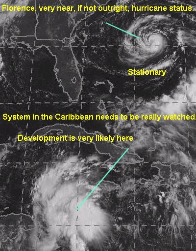
Today's big stories are the wave in the western Caribbean which could rapidly develop over the next few days (Probably more of a threat than Florence). However, Florence itself is looking very well and is for all practical purposes, a hurricane. Officially still a Tropical Storm, but its characteristics make it a sure bet to be upgraded later today.
Needless to say, Florence is still stagnating and moving very little. All indications say that it will move out to sea eventually. We'll still watch it.
Focus should be shifting toward the Western Caribbean, as the disturbance there has a very good chance to be upgraded today. It will eventually impact land, so I consider it more of a threat. Aircraft Recon is going out there to check and see if a definite circulation exists. If one exists now, it will form today. If not, it within the next two days.
Development Chances for this wave today:
(forget it) 0 1 2 3 4 5 6 7 8 9 10 (sure thing)
           [------------------*---]
|
||
Comments or Questions? Everyone is invited to use it. Use the comment button by the story Headline.
NRL Monterey Marine Meteorology Division Forecast Track of Active Systems (Good Forecast Track Graphic and Satellite Photos)Satellite images at: [N.A. visible] (visible -- Daytime Only) [N.A. infrared] (infrared), and [N.A. water vapor] (water vapor)--Nasa source.
Some Forecast models: (NGM, AVN, MRF, ECMWF, ETA)- [mac]