MikeC
Admin
Reged:
Posts: 4544
Loc: Orlando, FL
|
|
5PM Update
Lili strengthens to 105MPH...
A Hurricane Watch is now in effect along the northern Gulf Coast from san Louis pass Texas to the mouth of the Mississippi River.
a tropical storm watch is in effect east of the mouth of the Mississippi River to Pascagoula Mississippi... including New Orleans and lake ponchartrain.
Time to prepare there folks. Make use of tomorrow. Listen to local news media and authorities there.
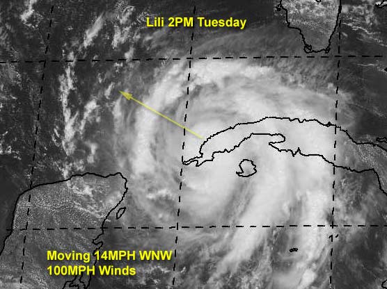
2PM Update
Lili is now a category II hurricane, and strengthening. No Yucatan to block it this time. Folks along the northern Gulf coast (especially toward Lousiana) should be watching this one closely. Note the forward speed of 14MPH. The wait won't be nearly as long as Isidore. In other words Lili is not FIzzledore.
Kyle is back from the dead again. It just doesn't want to go away.
Original Update
Hurricane Lili is nearing Cuba now, and will be moving over the western tip into the Gulf shortly. Much has not changed since yesterday. Still a potentially bad situiation in the gulf around Thursday. Upper Texas or Louisiana again.
Yesterday afternoon the site went down, but we are back up this morning, and we hope we have the situation resolved that caused the difficultly yesterday. (Grr) On the bright side, I have fixed the issue where the pop up advisories wouldn't be complete, or make the front page go missing. (Especially under stress of hurricane events)
Kyle has been downgraded to a Depression and isn't doing so well at the moment, and most likely won't restrengthen.
We'll update more as it comes in.
Havana, Cuba Radar
NRL Monterey Marine Meteorology Division Forecast Track of Active Systems (Good Forecast Track Graphic and Satellite Photos)
NASA GHCC Interactive Satellite images at:
North Atlantic Visible (Daytime Only), Infrared, Water Vapor
Some forecast models:
NGM, AVN, MRF, ETA ECMWF
DoD Weather Models (NOGAPS, AVN, MRF)
AVN, , , , , UKMET
Multi-model plots from WREL
Other commentary at Mike Anderson's East Coast Tropical Weather Center, Robert Lightbown/Crown Weather Tropical Update Accuweather's Joe Bastardi, Hurricane City Weather Audio Broadcast Network - Live Audio from Jim Williams and Barometer Bob , mpittweather , Tropical Weather Watchers.Com (JasonM) Gary Gray's Millennium Weather, Barometer Bob's Hurricane Hollow, Snonut, Ed Dunham and Jason M in our Storm Forum Even more on the links page.
- [mike@flhurricane.com]
|
BabyCat
Weather Guru
Reged:
Posts: 150
Loc: New Orleans, La.
|
|
Glad to see you're back, John!
This year reminds me of '98 in New Orleans. Every weekend for a month we had to prepare for a storm. Hopefully, New Orleans' luck will be the same again with no major hits.
|
jth
Storm Tracker
Reged:
Posts: 275
|
|
The new tropical models have shifted a little east. They no longer take Lili past 93. In fact, she may not make it past 92. The A98 has her making a very ominous landfall for New Orleans and the MS coast. Look for the track to be shifted a little east by the at next advisory. I will stick with my prediction of landfall within 100 miles of NO in either direction.(more likely west.)
|
tom5r
Weather Watcher
Reged:
Posts: 49
Loc: Islamorada, Florida
|
|
TESTING..TESTING...IS THIS THING ON?
Its great to see this site back up and running. Lets keep our fingers crossed! I just read Bastardi's column and he seems to be sticking with Lili becoming a MAJOR storm as she races across the gulf and has her hitting somewhere west of NO.
Here in the Keys we have winds around 20 mph, some spotty showers and some sun. Pretty much the same scenario as when Izzy was in the same location. It appears thatKyle has become a memory, at least for the time being.
Tom
|
usufruct
Registered User
Reged:
Posts: 7
|
|
If I'm not mistaken, Lilly is almost precisely where Isidore was and on about the same heading. Unusual, no?
|
Frank P
Veteran Storm Chaser
Reged:
Posts: 1299
|
|
Posted two days ago it would not be a texas storm, still think that.. ... models did shift east a little this morning and has me a little concerned, esp A98... that scenario would spell disaster for the MS coast... don't buy it yet... I still think Lili will hit west of New Orleans... within 100 miles or so... stay tuned...
Glad to see the site up and running, I was having withdrawals last night not having access.... hehe
|
tom
Unregistered
|
|
The 11:00 am advisory says it all. 
|
Frank P
Veteran Storm Chaser
Reged:
Posts: 1299
|
|
Per the Lili discussion at 11:00am
<<<HOWEVER...GIVEN THE SPREAD OF THE GUIDANCE AND THE UNCERTAINTIES OF THE FORECAST NEITHER THE NEW ORLEANS OR HOUSTON/GALVESTON AREAS ARE OUT OF DANGER>>>
Track not all that sure of after 36 hours... models not consistent.... stay tuned
|
JustMe
Weather Guru

Reged:
Posts: 128
Loc: Orlando, Florida
|
|
Yipeee Your back
I missed last evening when the system was down
You all are wonderful and the chatter has been great..
Thanks for making the season the best
Sue
--------------------
I have survived Betsy Miss, Camille Miss., Andrew Fl, Charley Fl, Frances FL, Jeanne FL,
|
Justin in Miami
Storm Tracker
Reged:
Posts: 269
Loc: Ft. Lauderdale, Florida
|
|
It appears Kyle is mystifying the models. They have him going in every direction. Can anyone explain this? Folks in LA better get ready indeed.
|
Unlogged Steve
Unregistered
|
|
I called New Iberia and I'm sticking with it. (Actually, I said Iberia/St. Mary Parishes) which are in SC-SW LA. I don't buy into the LA/TX border scenario, but obviously if Lili is heading NW at 15mph, it's not going to slow down and recurve, she's going to march. In any event, New Iberia is somewhat south of Lafayette and much closer to the coast. I don't think those guys have seen a storm in quite a while, whereas neighboring St. Mary Parish, got inundated with Andrew Part Deux.
If my landfall call was right, everyone between Lake Charles and Harrison Co. should have some effect. I think it's going to be different in New Orleans than Isidore was. For Isidore, we had 2 day rainfall totals > 20" in a large portion of the metro area. I don't see 'rainfall' flooding with Lili, but a real live shot at some serious tidal flooding cannot be ignored. Additionally, there should be massive power outages along with many more tornadoes (especially east of landfall) and much more wind.
T-60 and counting! Time to re-up the beer.
Steve
|
Rich B
British Meteorologist
Reged:
Posts: 498
Loc: Gloucestershire, England, UK
|
|
The radar data from Havana showed a well developed eye and eyewall structure as Lily approached the southwestern tip of the Isle of Youth. In fact, it seems that it is only recently as the circulation to the north of the centre interacts with Cuba itself, that the eyewall has begun to collapse. The transition across Cuba and back into the Gulf of Mexico should not take more than a few hours, so this is most likely only a temporary interruption to the system. Just found it of interest though, as this part of Cuba is relatively flat, and i did not think it would have as much effect on the Hurricane as it has.
OK, time for my predicted landfall... somewhere near Morgan City later Thursday....
Rich B
StormWarn2000
--------------------
Rich B
SkyWarn UK
|
Frank P
Veteran Storm Chaser
Reged:
Posts: 1299
|
|
This is getting really close to my May prediction that the Big Easy was due for the BIG ONE. It might just boil down to about 75 miles or so... at least it still has some potential to come to fruition.... It's October... it's going to turn north eventually... timing is everything with this one....
Regardless, it doesn't look good for the state of LA... might just end up being the storm of the decade for someone....
|
HanKFranK
User

Reged:
Posts: 1841
Loc: Graniteville, SC
|
|
lili: intensity forecast coming off o.k. so far.. a little low, as it were. 11pm last night had the storm at 80mph/983mb.. actual was 85mph/978mb. just now i had guessed the storm would be 85/978.. it is 90/971. staying within my 15mph/8mb margin of error so far.. barely. sticking with beaumont tx, with any corrections east.. not by much. not betting on this one really getting new orleans. it is going to cross the lowland western tip of cuba fairly soon.. some higher terrain will be just north of the center and we may see a slight weakening. as for the storm treading tainted waters, it is going right along the path isidore took.. which should begin to diverge some later today. as far as oceanic heat content, i remember the guys saying isidore could move very slowly and not have to worry about upwelling due to the deep layer of warm water. my philosophy is, if isidore couldnt ruin it all, moving at about 5mph, why should lili moving at 13?
kyle has returned to tropical storm strength.. had overdone the weakening.. as some uncontaminated quickscat vectors were as high as 45kt. likes to underrate whenever possible, so kyle is assigned a 35kt intensity. been moving erratically this morning (a cyclonic loop).. now drifting nw in the latest frames. heavy subsedence descending from the north for another 24hr, then shear lightens and atmospheric moisture increases.. so i expect kyle to change little in the next 24, then slowly intensify and recover. with vertical depth a motion generally to the southwest should convene.
east of bermuda the part of kyle that merged into the front is an e-w elongated low pressure area... based on the convection it is generating and the fairly sharp nature of the axis at the surface i'd say it has a fair chance at development.
94L is still there, and now past the harshest shear. elongated n-s.. hard to say which part of its axis is dominant. expect this to slowly develop now, as it has survived and is on the back side of the upper trough axis.
that small rotation i mentioned yesterday 400mi east of trinidad has convection to its north now.. not well defined, but conditions aloft not wholly unfavorable. dont know what to expect here. is recognizing the low but not saying one thing or another about it.
wave 500mi east of the cape verdes is now heading into 94L's shear axis. some convection with the .. but no time to organize.
HF 1525z01october
|
tom5r
Weather Watcher
Reged:
Posts: 49
Loc: Islamorada, Florida
|
|
Steve,
better get a keg when you re-up the beer supply. It may be a long week. I was looking at the system east of the windwards early this morning. Looked kinda ominous, following the same track as Izzy and Lili. Guess we'd better start keeping one eye out for that.
|
tom5r
Weather Watcher
Reged:
Posts: 49
Loc: Islamorada, Florida
|
|
Key West long range radar shows Lili's center about halfway over western Cuba. She should be mong off to the gulf side in an hour or two.
http://www.srh.noaa.gov/radar/loop/DS.p20-r/si.kbyx.shtml
|
jth
Storm Tracker
Reged:
Posts: 275
|
|
here is a link that you might find interesting. No storm since they began keeping records that was within 200 miles of Lili's current position in October ever made landfall west of NO.
http://www.weatherunderground.com/tropical/tracking/at200213_climo.html
|
Brad in Miami
Unregistered
|
|
But notice that's only category 1 and 2 hurricanes. I wonder if the statistics change with the inclusion of weaker or stronger storms.
-Brad
|
jth
Storm Tracker
Reged:
Posts: 275
|
|
good question
|
jth
Storm Tracker
Reged:
Posts: 275
|
|
check this out. Texas has never been hit by a major hurricane in October
http://www.nhc.noaa.gov/paststate.html
|


 Threaded


