MikeC
Admin
Reged:
Posts: 4544
Loc: Orlando, FL
|
|
2:30 PM Aug 1 Update: TD 1 Becomes Tropical Storm Alex
We now have our first named system of this season. At 2PM, upgraded TD1 to TS Alex - located about 80 miles SSE of Charleston, South Carolina. Alex is a minimal TS with sustained winds of 35 knots, and it is currently stationary. The still expects Alex to eventually move to the north and northeast so Tropical Storm Warnings remain in effect for the coastal areas of the Carolinas.
Personally, I would have placed the center a lot further to the south based on the main feeder band, but since the storm has about a half dozen areas of low-level circulation, I guess that for the moment, any one of them will do. Coastal residents of Georgia should also keep a close eye on Alex.
ED
10:45 AM Aug 1 Update:
Tropical Storm Warnings are now up from Cape Fear to Cape Hatteral in North Carolina.
10:30 AM Aug 1 Update:
Tropical Depression 1 is looking better this morning, with T#s at 2.0. There is a good chance it'll become Tropical Storm Alex today, but due to its proximity to land the likelyhood of it strengthening much more is slip.
However, I do suspect it will be in strengthening mode when it does make landfall. It's center seems to be reforming now, or adjustin itself.
More to come later.
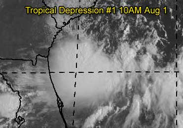
Original Update
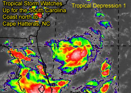
Tropical Depression One has formed east of the Florida Peninsula, and is still rather disorganized. It's track takes it northward towards the Carolinas, and because of this, Tropical Storm Watches are out for South Carolina all the way up to Cape Hatteras in North Carolina.
Folks in the area should be aware of it.
The system in the Gulf (90L) is looking very ragged now, and may not form into a depression. But another storm west of the Cape Verde Islands in the far eastern Atlantic may form over the next few days and become our first "cape verde" tracker of the season. We'll keep an eye out on everything.
More updates to come on TD#1...
Event Related Links
Charleston, SC Long Range Radar
Jacksonville, FL Long Range Radar
General Links
Current Aircraft Recon Info
NRL Monterey Marine Meteorology Division Forecast Track of Active Systems (Good Forecast Track Graphic and Satellite Photos)
Check the Storm Forum from time to time for comments on any new developing system.
Follow worldwide SST evolution here:
Global SST Animation
NASA GHCC Interactive Satellite images at:
North Atlantic Visible (Daytime Only), Infrared, Water Vapor
Some forecast models:
NGM, AVN, MRF, ETA ECMWF
AVN, , , JMA, , UKMET
DoD Weather Models (NOGAPS, AVN, MRF)
Multi-model plots from WREL
Other commentary at Mike Anderson's East Coast Tropical Weather Center, Independentwx.com, Robert Lightbown/Crown Weather Tropical Update Accuweather's Joe Bastardi (now subcriber only unfortunately), Hurricane Alley North Atlantic Page, Cyclomax (Rich B.), Hurricane City , mpittweather , Gary Gray's Millennium Weather, Barometer Bob's Hurricane Hollow, Snonut,
Even more on the links page.
Edited by Ed Dunham (Sun Aug 01 2004 06:47 PM)
|
LI Phil
User

Reged:
Posts: 2637
Loc: Long Island (40.7N 73.6W)
|
|
Thanks for the new thread Mike. Looks like TD1 won't be Alex until August, although I do believe this will become Alex sometime tomorrow. Ed's 7/31 guess was pretty good. Old Sailor may get our first named storm on his 75th birthday.
--------------------
2005 Forecast: 14/7/4
BUCKLE UP!
"If your topic ain't tropic, your post will be toast"
|
hurricane_run
Storm Tracker

Reged:
Posts: 366
Loc: USA
|
|
000
WTNT31 KNHC 312340
TCPAT1
BULLETIN
TROPICAL DEPRESSION ONE INTERMEDIATE ADVISORY NUMBER 1A
NWS TPC/NATIONAL HURRICANE CENTER MIAMI FL
8 PM EDT SAT JUL 31 2004
...TROPICAL DEPRESSION REMAINS POORLY ORGANIZED...
A TROPICAL STORM WATCH REMAINS IN EFFECT FROM EDISTO BEACH SOUTH
CAROLINA TO CAPE HATTERAS NORTH CAROLINA...INCLUDING THE PAMLICO
SOUND. A TROPICAL STORM WATCH MEANS THAT TROPICAL STORM CONDITIONS
ARE POSSIBLE IN THE WATCH AREA DURING THE NEXT 36 HOURS.
AT 8 PM EDT...0000Z...THE POORLY DEFINED CENTER OF TROPICAL
DEPRESSION ONE WAS ESTIMATED NEAR LATITUDE 30.9 NORTH...LONGITUDE
78.6 WEST OR ABOUT 145 MILES SOUTH-SOUTHEAST OF CHARLESTON SOUTH
CAROLINA.
THE DEPRESSION HAS BEEN MEANDERING DURING THE PAST COUPLE OF HOURS
BUT IT SHOULD BEGIN TO MOVE TOWARD THE NORTHWEST NEAR 9 MPH LATER
TONIGHT. A GRADUAL TURN TOWARD THE NORTH IS EXPECTED DURING THE
NEXT 24 HOURS. THIS MOTION COULD BRING THE CENTER OF THE TROPICAL
CYCLONE NEAR THE COAST OF THE SOUTHEASTERN UNITED STATES ON SUNDAY.
PRELIMINARY REPORTS FROM THE RECONNAISSANCE AIRCRAFT INDICATE THAT
THE DEPRESSION IS POORLY ORGANIZED. MAXIMUM SUSTAINED WINDS REMAIN
NEAR 30 MPH...WITH HIGHER GUSTS...MAINLY IN SQUALLS TO THE SOUTH
AND EAST OF THE CENTER. SOME SLOW STRENGTHENING IS FORECAST DURING
THE NEXT 24 HOURS...AND THE DEPRESSION COULD BECOME A TROPICAL
STORM ON SUNDAY.
ESTIMATED MINIMUM CENTRAL PRESSURE IS 1010 MB...29.83 INCHES.
REPEATING THE 8 PM EDT POSITION...30.9 N...78.6 W. MOVEMENT
NEARLY STATIONARY. MAXIMUM SUSTAINED WINDS... 30 MPH. MINIMUM
CENTRAL PRESSURE...1010 MB.
FOR STORM INFORMATION SPECIFIC TO YOUR AREA...PLEASE MONITOR
PRODUCTS ISSUED BY YOUR LOCAL WEATHER OFFICE.
THE NEXT ADVISORY WILL BE ISSUED BY THE National Hurricane Center AT
11 PM EDT.
FORECASTER AVILA
|
hurricane_run
Storm Tracker
Reged:
Posts: 366
Loc: USA
|
|
strengths the same but it hasnt moved much. it will have more time to strengthen
|
Anonymous
Unregistered
|
|
Well, I have done better this time...back on Wed I predicted (and posted it here on Thurs) that within 72 hours we would have a depression east of fl....now for the hard part....also predicted one in the Gulf in 120 hrs....@48 hours to go....
sc 
|
LI Phil
User
Reged:
Posts: 2637
Loc: Long Island (40.7N 73.6W)
|
|
I can't seem to find any data from the second recon flight this afternoon. Anyone know what they found?
--------------------
2005 Forecast: 14/7/4
BUCKLE UP!
"If your topic ain't tropic, your post will be toast"
|
Rich B
British Meteorologist
Reged:
Posts: 498
Loc: Gloucestershire, England, UK
|
|
Hey guys,
apologies for the late post but been at work all day and then out this evening celebrating my birthday (25 today!). And looks like i got a decent present too, the first classified system of the 2004 season. Like most of you i dont expect we'll see our first named system til August, but at least we finally have some 'proper' activity. Plenty to watch too as in the previous news item. The wave west of the CV islands actually has been asessed by SSD but no assigned TNumbers as its 'TOO WEAK'. Certainly something else to watch though.
As for TD One. Well i dont expect it to be anything spectacular really. Possibly intensifying to a weak Tropical Storm on Sunday. Landfall, if it happens and the system doesnt recurve out to sea, will probably be as a minimal Tropical Storm with sustained winds of around 45 mph. However, the fact it hasnt moved alot recently suggests it is in the formative stages, and may actually strengthen a little more if it remains over water a little longer.
Anyway, will post more thoughts in the morning.
Kind regards
--------------------
Rich B
SkyWarn UK
|
LI Phil
User
Reged:
Posts: 2637
Loc: Long Island (40.7N 73.6W)
|
|
Happy 25th guy. You really should post your birthday on your home page, then it'd get on the calendar!
You today, Old Sailor tomorrow. Looks like you both get some b-day presents. Thanks for the hEDs up on the CV wave. Will have to keep atop that one.
Well, I'll let you enjoy your special day. Hopefully your dinner wasn't bangers and mash, enjoy a nice warm bitters for me.
Cheer-e-o,
LI Phil
--------------------
2005 Forecast: 14/7/4
BUCKLE UP!
"If your topic ain't tropic, your post will be toast"
|
Storm Cooper
User
Reged:
Posts: 1290
Loc: Panama City , FL
|
|
Happy Bday to all! Glad to see some sort of season begin! I still have hope for the little GOM low if it can hang around a day or so. This Buds for you LIPhil!
--------------------
Hurricane Season 2017 13/7/1
|
danielw
Moderator

Reged:
Posts: 3525
Loc: Hattiesburg,MS (31.3N 89.3W)
|
|
This is the highest wind speed they've tranmitted so far. This was at 8:19EDT. They are still looking. I seem to recall seeing that they were taked until 10 or 11pm EDT tonite.URNT11 KNHC 010019
97779 00194 10300 77600 02900 22026 2322/ /0012
RMK AF963 0301A CYCLONE OB 10
That's 220 degrees at 26 knots. It looks like thats a low level observation.
|
Jamiewx
Storm Tracker

Reged:
Posts: 371
Loc: Orlando, Florida
|
|
Well done Ed on coming the closest with the predictions, it may not be the first tropical storm yet, but it is the first tropical cyclone and thats close enough for me. Guess after you have been doing this stuff as long as Ed has you get closer and closer everytime. 
--------------------
"Climate is what you expect, weather is what you get"
- Robert A. Heinlein
|
LI Phil
User
Reged:
Posts: 2637
Loc: Long Island (40.7N 73.6W)
|
|
DanW,
Thanks. So they're still zig-zagging through the blob?
--------------------
2005 Forecast: 14/7/4
BUCKLE UP!
"If your topic ain't tropic, your post will be toast"
|
Cycloneye
Storm Tracker
Reged:
Posts: 373
Loc: Puerto Rico
|
|
31/2345 UTC 11.1N 33.8W T1.0/1.0 90 -- Atlantic Ocean
Interesting the classification and It looks better than TD #1.
--------------------
My 2004 hurricane season forecast=13/8/3
|
danielw
Moderator
Reged:
Posts: 3525
Loc: Hattiesburg,MS (31.3N 89.3W)
|
|
LI Phil,
Yes, at least they shouldn't have to worry about any turbulence.
Old 90 still managing to fire up some high tops even this late in the day. Appears to be a " ring of fire" centered near 23.0N and 90.0W. IR tops oscillating from the NE quad to the NW quad, last hour. Buoys still don't look that impressive. If it maintains a W-ward drift the Bay of Campeche should bump it up a notch, if at all. You"d think the cool front will pick it up and run it through FL. We'll just have to keep an eye-no pun on it.
|
Rabbit
Weather Master

Reged:
Posts: 511
Loc: Central Florida
|
|
east atlantic wave
It is entirely possible that the wave at about 32W could be a TD within 24 to 48 hours, and maybe even a storm after that
Every time I saw the satellite image for it today, it has become better organized each time
This may very well be the system all the models have been hinting at for the last week.
This is starting to remind me of 1999 in mid August. NOTHING from early July to August, then sever storms in a row pop up:
Bret Aug 18, Cindy Aug 18, Aug 23, Emily Aug 24
wave off of Africa doesnt look all that organized, but could also develop as it moves off
As for TD1, I agree with everyone else that it will not become a TS until tomorrow, if at all, and will not strengthen beyond the forecast.
|
Rabbit
Weather Master
Reged:
Posts: 511
Loc: Central Florida
|
|
of the TD and the wave
http://www.goes.noaa.gov/HURRLOOPS/huirloop.html
|
danielw
Moderator
Reged:
Posts: 3525
Loc: Hattiesburg,MS (31.3N 89.3W)
|
|
I think they might better bump up the on the wave. It's moving at a fairly good speed. At that speed it might shear itself to pieces.
|
hurricane_run
Storm Tracker
Reged:
Posts: 366
Loc: USA
|
|
000
WTNT31 KNHC 010228
TCPAT1
BULLETIN
TROPICAL DEPRESSION ONE ADVISORY NUMBER 2
NWS TPC/NATIONAL HURRICANE CENTER MIAMI FL
11 PM EDT SAT JUL 31 2004
...TROPICAL DEPRESSION REMAINS DISORGANIZED...
A TROPICAL STORM WATCH REMAINS IN EFFECT FROM EDISTO BEACH SOUTH
CAROLINA TO CAPE HATTERAS NORTH CAROLINA...INCLUDING THE PAMLICO
SOUND. A TROPICAL STORM WATCH MEANS THAT TROPICAL STORM CONDITIONS
ARE POSSIBLE IN THE WATCH AREA DURING THE NEXT 36 HOURS.
AT 11 PM EDT...0300Z...THE CENTER OF TROPICAL DEPRESSION ONE WAS
LOCATED NEAR LATITUDE 31.4 NORTH...LONGITUDE 78.9 WEST OR ABOUT
115 MILES... 185 KM...SOUTHEAST OF CHARLESTON SOUTH CAROLINA.
THE DEPRESSION IS MOVING TOWARD THE NORTH-NORTHWEST NEAR 8 MPH
...13 KM/HR...AND THIS MOTION IS EXPECTED TO CONTINUE DURING THE
NEXT 24 HOURS. THIS MOTION COULD BRING THE CENTER OF THE TROPICAL
CYCLONE NEAR THE COAST OF THE SOUTHEASTERN UNITED STATES ON SUNDAY.
DATA FROM THE RECONNAISSANCE PLANE INDICATE THAT THE DEPRESSION
REMAINS DISORGANIZED. MAXIMUM SUSTAINED WINDS ARE NEAR 30 MPH...45
KM/HR...WITH HIGHER GUSTS IN A FEW SQUALLS TO THE EAST AND SOUTH OF
THE CENTER. LITTLE CHANGE IN STRENGTH IS FORECAST DURING THE NEXT
24 HOURS.
ESTIMATED MINIMUM CENTRAL PRESSURE IS 1009 MB...29.80 INCHES.
REPEATING THE 11 PM EDT POSITION...31.4 N... 78.9 W. MOVEMENT
TOWARD...NORTH-NORTHWEST NEAR 8 MPH. MAXIMUM SUSTAINED
WINDS... 30 MPH. MINIMUM CENTRAL PRESSURE...1009 MB.
FOR STORM INFORMATION SPECIFIC TO YOUR AREA...PLEASE MONITOR
PRODUCTS ISSUED BY YOUR LOCAL WEATHER OFFICE.
AN INTERMEDIATE ADVISORY WILL BE ISSUED BY THE NATIONAL HURRICANE
CENTER AT 2 AM EDT FOLLOWED BY THE NEXT COMPLETE ADVISORY AT 5 AM
EDT.
FORECASTER AVILA
|
hurricane_run
Storm Tracker
Reged:
Posts: 366
Loc: USA
|
|
it started to move again. and the pressure has dropped only
1 mb "LITTLE CHANGE IN STRENGTH IS FORECAST DURING THE NEXT 24 HOURS. "
Edited by hurricane_run (Sun Aug 01 2004 02:43 AM)
|
Old Sailor
Storm Tracker

Reged:
Posts: 293
Loc: Florida
|
|
TD 1 , may just stay as a TD a rain maker to the southeast coast, 90L also doesn't appear to be getting it's act together, keeps drifting to the west, more like a wagon train, but you never know with any low in the GOM , not betting on this one to do anything.
Dave
|


 Threaded


