F
Current Radar or Satellite Image

Flhurricane.com - Central Florida Hurricane Center - Tracking Storms since 1995Hurricanes Without the Hype! Since 1995


The 2024 Atlantic Hurricane Season Begins on June 1st and lasts until Nov 30th. NHC Outlooks resume on May 15th..
Days since last H. Landfall - US: Any 237 (Idalia) , Major: 237 (Idalia) Florida - Any: 237 (Idalia) Major: 237 (Idalia)


Archives 2010s >> 2013 News Talkbacks

Pages: 1
cieldumort
Moderator


Reged:
Posts: 2305
Loc: Austin, Tx
Invest 99L (EIGHT) a Threat to Mexico. X-Gabrielle Percolating
      #94762 - Fri Sep 06 2013 05:11 PM

Update 12:30 PM CDT 6 September 2013
NHC has just announced that 99L is being upgraded, and advisories on TD8 (or a named storm) will be issued within the next hour or two.
Ciel

Original Entry 11:30 AM CDT 5 September 2013
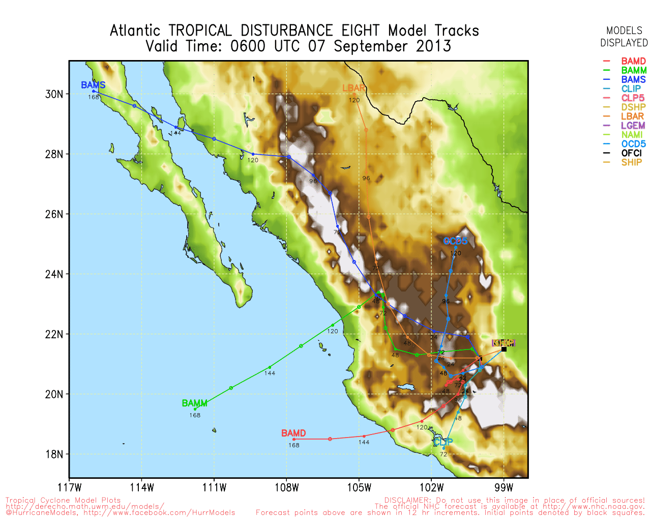
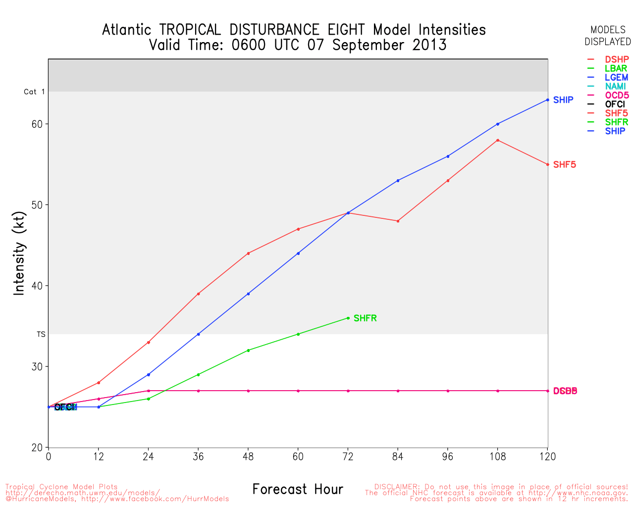
A very well developed area of low pressure in the far western Gulf of Mexico (99L) is pushing inland today, Sept 6, with heavy rains forecast for eastern Mexico.

After tracking across the Yucatan and developing a closed but broad circulation, Invest 99L appears to be getting much more organized today right as it is pushing inland. This can sometimes occur, as systems often tend to fold into themselves in response to running into land. Also, particularly in the western Gulf of Mexico, the general day-to-day windflow frequently favors cyclogenesis.

Invest 99L presently has maximum sustained winds of at least 35MPH, and is expected to produce widespread rains of up to 5", with locally much higher amounts possible.

A Special Advisory was issued by NHC around 10:30AM CDT, anticipating that the system would be inland prior to becoming a tropical cyclone, but this looks like a very close call, and many of the same types of hazards will result from 99L at this point, regardless of further development.

Elsewhere in the Tropical Atlantic, x Tropical Storm Gabrielle is actually percolating just a little bit yet again today, and will continue to be watched for any signs of meaningful reorganization. A few other tropical waves are present, but conditions do not appear immediately favorable for their near-term development.
Ciel


Post Extras: Print Post   Remind Me!   Notify Moderator  
cieldumort
Moderator


Reged:
Posts: 2305
Loc: Austin, Tx
Re: Invest 99L (EIGHT) a Threat to Mexico. X-Gabrielle Percolating [Re: cieldumort]
      #94764 - Fri Sep 06 2013 07:27 PM

EIGHT has made landfall as quickly as its advisories were announced, and no further organization is anticipated. However, the depression is expected to slowly push west to southwest into eastern Mexico, wringing out heavy rains along its track, with an attendant flood threat.

A few outermost bands or loosely related seabreeze showers and storms may make their way into south Texas, but that will probably be about the extent of any near term US impact.


Post Extras: Print Post   Remind Me!   Notify Moderator  
Pages: 1


Extra information
0 registered and 0 anonymous users are browsing this forum.

Moderator:  

Print Topic

Forum Permissions
      You cannot start new topics
      You cannot reply to topics
      HTML is disabled
      UBBCode is enabled

Rating:
Topic views: 2839

Rate this topic

Jump to

Note: This is NOT an official page. It is run by weather hobbyists and should not be used as a replacement for official sources. 
CFHC's main servers are currently located at
Hostdime.com in Orlando, FL.
Image Server Network thanks to Mike Potts and Amazon Web Services. If you have static file hosting space that allows dns aliasing contact us to help out! Some Maps Provided by:
Great thanks to all who donated and everyone who uses the site as well. Site designed for 800x600+ resolution
When in doubt, take the word of the National Hurricane Center