F
Current Radar or Satellite Image

Flhurricane.com - Central Florida Hurricane Center - Tracking Storms since 1995Hurricanes Without the Hype! Since 1995


The 2024 Atlantic Hurricane Season Begins on June 1st and lasts until Nov 30th. NHC Outlooks resume on May 15th..
Days since last H. Landfall - US: Any 238 (Idalia) , Major: 238 (Idalia) Florida - Any: 238 (Idalia) Major: 238 (Idalia)


Archives 2010s >> 2014 News Talkbacks

Pages: 1
MikeCAdministrator
Admin


Reged:
Posts: 4544
Loc: Orlando, FL
Cristobal Forms and Heading Out to Sea
      #95266 - Sun Aug 24 2014 12:24 PM

The mess that was 96L and TD#4 finally has consolidated enough to become a Tropical Storm, and appears to have done so far enough to the north and east to now be forecast to miss much of the Bahamas and the US entirety. The period of uncertainty that existed in the undeveloped system is now mostly over. Avoiding a troublesome lead-up toward Labor day Weekend.

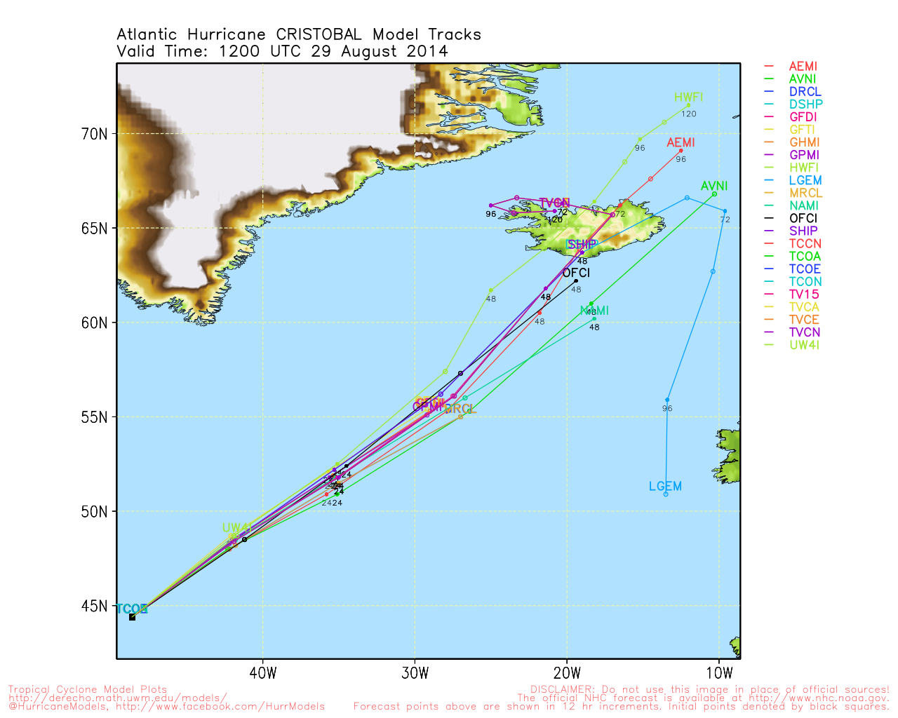
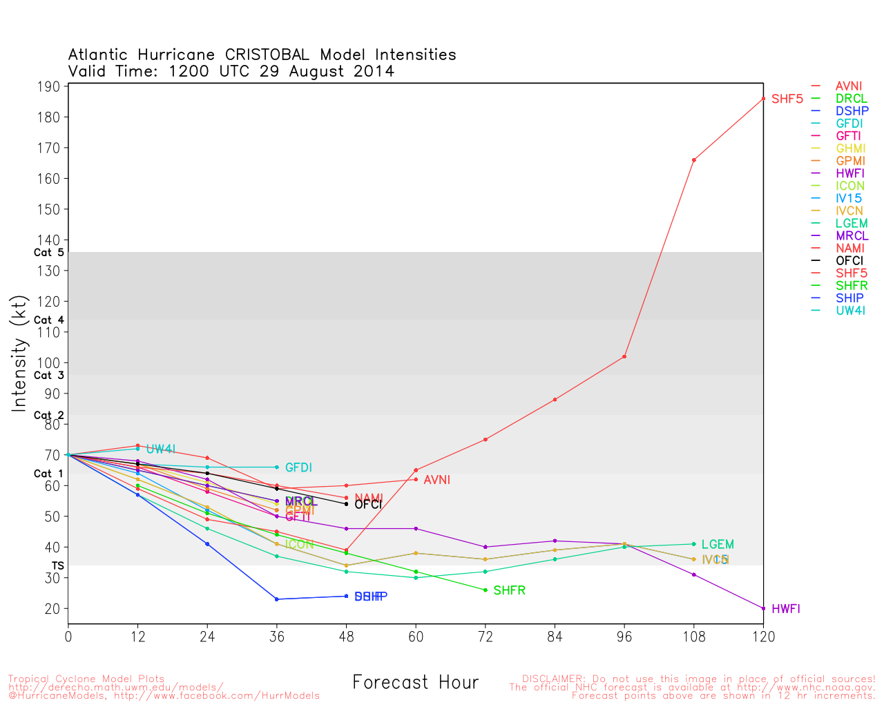
Cristobal likely will meander around and just north of where it is for the next few days before moving on out over the ocean, it may become a Hurricane over the open waters Wednesday or Thursday.

Beyond Cristobal there may be something to watch a week from now, but nothing currently being watched.

Texas Gulf Coast Links [http://moe.met.fsu.edu/~mnissenbaum/radar.html Mark Nissenbaum's radar page} East to West:

<html> <a href="https://radar.weather.gov/ridge/lite/K</html>HGX<html>_loop.gif" onMouseover="ddrivetip('<img src=\'https://radar.weather.gov/ridge/lite/K</html>HGX<html>_loop.gif\'>');" onMouseout="hideddrivetip();"></html>Houston/Galveston, TX Radar<html> Radar Loop</A>

(<a href="https://radar.weather.gov/ridge/lite/K</html>HGX<html>_0.gif" onMouseover="ddrivetip('<img src=\'https://radar.weather.gov/ridge/lite/K</html>HGX<html>_0.gif\'>');" onMouseout="hideddrivetip();">Latest Static</a>)</html>

<html> <a href="https://radar.weather.gov/ridge/lite/K</html>CRP<html>_loop.gif" onMouseover="ddrivetip('<img src=\'https://radar.weather.gov/ridge/lite/K</html>CRP<html>_loop.gif\'>');" onMouseout="hideddrivetip();"></html>Corpus Christi, TX Radar<html> Radar Loop</A>

(<a href="https://radar.weather.gov/ridge/lite/K</html>CRP<html>_0.gif" onMouseover="ddrivetip('<img src=\'https://radar.weather.gov/ridge/lite/K</html>CRP<html>_0.gif\'>');" onMouseout="hideddrivetip();">Latest Static</a>)</html>

<html> <a href="https://radar.weather.gov/ridge/lite/K</html>BRO<html>_loop.gif" onMouseover="ddrivetip('<img src=\'https://radar.weather.gov/ridge/lite/K</html>BRO<html>_loop.gif\'>');" onMouseout="hideddrivetip();"></html>Brownsville, TX Radar<html> Radar Loop</A>

(<a href="https://radar.weather.gov/ridge/lite/K</html>BRO<html>_0.gif" onMouseover="ddrivetip('<img src=\'https://radar.weather.gov/ridge/lite/K</html>BRO<html>_0.gif\'>');" onMouseout="hideddrivetip();">Latest Static</a>)</html>

Gulf of Mexico Satellite Imagery

Area Forecast Discussions: Houston/Galveston, TX - Corpus Christi, TX - Browsnville/South Padre Island, TX


Post Extras: Print Post   Remind Me!   Notify Moderator  
Bloodstar
Moderator


Reged:
Posts: 462
Loc: Tucson, AZ
Re: Cristobal Forms and Heading Out to Sea [Re: MikeC]
      #95274 - Mon Aug 25 2014 05:07 PM

What an ugly looking storm, surface low exposed, with the convection all pushed to the south and east. I suppose the stationary front is going to pull the storm off the coast. I don't see any real reason why it won't happen, but Cristobal really seems to be struggling to make any real headway north and instead meandering very slowly north.

Shouldn't cause any real problems for the US though, at least not beyond some high surf and some rip currents.

--------------------
M. S. Earth and Atmospheric Sciences, Georgia Tech - May 2020
Brookhaven National Laboratory
U. Arizona PhD Student


Post Extras: Print Post   Remind Me!   Notify Moderator  
Pages: 1


Extra information
0 registered and 0 anonymous users are browsing this forum.

Moderator:  

Print Topic

Forum Permissions
      You cannot start new topics
      You cannot reply to topics
      HTML is disabled
      UBBCode is enabled

Rating:
Topic views: 2438

Rate this topic

Jump to

Note: This is NOT an official page. It is run by weather hobbyists and should not be used as a replacement for official sources. 
CFHC's main servers are currently located at
Hostdime.com in Orlando, FL.
Image Server Network thanks to Mike Potts and Amazon Web Services. If you have static file hosting space that allows dns aliasing contact us to help out! Some Maps Provided by:
Great thanks to all who donated and everyone who uses the site as well. Site designed for 800x600+ resolution
When in doubt, take the word of the National Hurricane Center