F
Current Radar or Satellite Image

Flhurricane.com - Central Florida Hurricane Center - Tracking Storms since 1995Hurricanes Without the Hype! Since 1995


The 2024 Atlantic Hurricane Season Begins on June 1st and lasts until Nov 30th. NHC Outlooks resume on May 15th..
Days since last H. Landfall - US: Any 237 (Idalia) , Major: 237 (Idalia) Florida - Any: 237 (Idalia) Major: 237 (Idalia)


Archives 2020s >> 2022 News Talkbacks

Pages: 1
MikeCAdministrator
Admin


Reged:
Posts: 4544
Loc: Orlando, FL
November Areas that should be Watched Closely
      #114439 - Sun Nov 06 2022 12:02 AM

1:30PM EST 6 November 2022 Update
The area north of Puerto rico is up to 90% chance to develop in the next 5 days. The National Hurricane Center has indicated that tropical storm, hurricane, and storm surge watches could go up as early as tomorrow morning for parts of the Central and Northwestern Bahamas and Florida east coast for the system which would likely arrive in the middle part of the week (Wednesday Night or Thursday). Regardless of development or exact track, there is risk of coastal flooding, tropical storm force winds (with a high gradient driven pattern), heavy rain, rough surf and beach erosion along the east Florida coast. It's important to monitor this system closely over the next few days.


7AM EST 6 November 2022 Update
The area east of Bermuda has a 70% chance to develop.

The bigger story is the area north of Puerto Rico that now has a 90% chance to develop into a tropical or subtropical storm, now with most of the major forecast models projecting a potential hurricane approaching the Bahamas and Florida on top of it, forecast advisories are very likely to begin at least late today on this system. For local information please check officials and local media. It may be very close to Florida late Wednesday night or Early Thursday morning.

This system is likely going to a be a large system, with a large wind field because of strong pressure gradients with a high to the north, which will likely translate into a lot of coastal erosion and flooding along the east coast of Florida and north, potentially up to North Carolina. Beaches will likely be very dangerous for currents into the week. Rainfall from this area in Puerto Rico has brought flooding conditions there.

This system at least will be impactful to east Florida in the form of wind, rainfall, and dangerous beach/marine conditions. Depending on the system's strength and track, significant rainfall and increased flooding, surge and wind concerns may also unfold. Important to note that the pattern setting up for this allows this system to continue to strengthen even right up to a potential landfall.

Original Update

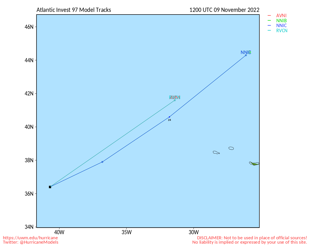
Two areas are red on the outlook map this evening, the area east of Bermuda (Invest 97L), which has a 70% chance to develop over the next 48 hours.

The other area, currently near Puerto Rico and heading toward the general vicinity of the Bahamas, has an 80% chance to develop over the next 5 days, and 50% in the next 48 hours. It's currently bringing flooding rainfall to parts of Puerto Rico. This system those in the Bahamas, Florida, and the Southeast US needs to watch closely as it has the potential to become tropical or subtropical over the next few days. And this along with a high pressure more to the north will likely create a large windfield which will increase risk of coastal flooding, erosion and very high surf along the east coast of Florida potentially up through North Carolina. There remains a possibility it could get stronger as well, so it's important that it be watched closely by those in the Bahamas and the east coast of Florida.

The next two names on the list are Nicole and Owen.


East Florida Links <html><a href="http://radar.weather.gov/ridge/Conus/southeast_lite_loop.php" onMouseover="ddrivetip('<img src=\'http://radar.weather.gov/ridge/Conus/Loop/southeast_loop.gif\'>');" onMouseout="hideddrivetip();">Southeast Composite Radar Loop</A>

(<a href="http://radar.weather.gov/ridge/Conus/southeast_lite.php" 

onMouseover="ddrivetip('<img src=\'http://radar.weather.gov/ridge/Conus/RadarImg/southeast.gif\>');" onMouseout="hideddrivetip();">Latest Static</a></html>) South to North:

<html> <a href="https://radar.weather.gov/ridge/lite/K</html>BYW<html>_loop.gif" onMouseover="ddrivetip('<img src=\'https://radar.weather.gov/ridge/lite/K</html>BYW<html>_loop.gif\'>');" onMouseout="hideddrivetip();"></html>Key West, FL Radar<html> Radar Loop</A>

(<a href="https://radar.weather.gov/ridge/lite/K</html>BYW<html>_0.gif" onMouseover="ddrivetip('<img src=\'https://radar.weather.gov/ridge/lite/K</html>BYW<html>_0.gif\'>');" onMouseout="hideddrivetip();">Latest Static</a>)</html>

<html> <a href="https://radar.weather.gov/ridge/lite/K</html>AMX<html>_loop.gif" onMouseover="ddrivetip('<img src=\'https://radar.weather.gov/ridge/lite/K</html>AMX<html>_loop.gif\'>');" onMouseout="hideddrivetip();"></html>Miami, FL Radar<html> Radar Loop</A>

(<a href="https://radar.weather.gov/ridge/lite/K</html>AMX<html>_0.gif" onMouseover="ddrivetip('<img src=\'https://radar.weather.gov/ridge/lite/K</html>AMX<html>_0.gif\'>');" onMouseout="hideddrivetip();">Latest Static</a>)</html>

<html> <a href="https://radar.weather.gov/ridge/lite/K</html>MLB<html>_loop.gif" onMouseover="ddrivetip('<img src=\'https://radar.weather.gov/ridge/lite/K</html>MLB<html>_loop.gif\'>');" onMouseout="hideddrivetip();"></html>Melbourne, FL Radar<html> Radar Loop</A>

(<a href="https://radar.weather.gov/ridge/lite/K</html>MLB<html>_0.gif" onMouseover="ddrivetip('<img src=\'https://radar.weather.gov/ridge/lite/K</html>MLB<html>_0.gif\'>');" onMouseout="hideddrivetip();">Latest Static</a>)</html>

<html> <a href="https://radar.weather.gov/ridge/lite/K</html>JAX<html>_loop.gif" onMouseover="ddrivetip('<img src=\'https://radar.weather.gov/ridge/lite/K</html>JAX<html>_loop.gif\'>');" onMouseout="hideddrivetip();"></html>Jacksonville, FL Radar<html> Radar Loop</A>

(<a href="https://radar.weather.gov/ridge/lite/K</html>JAX<html>_0.gif" onMouseover="ddrivetip('<img src=\'https://radar.weather.gov/ridge/lite/K</html>JAX<html>_0.gif\'>');" onMouseout="hideddrivetip();">Latest Static</a>)</html>


Caribbean/South East Coast Satellite Imagery


SFWMD Radar Loop of South Florida with storm Track


SFWMD Full Florida Radar Loop with Storm Track


Area Forecast Discussions: FLorida Keys - Miami/South Florida - Melbourne/East Central Florida - Jacksonville/Northeast Florida -


Post Extras: Print Post   Remind Me!   Notify Moderator  
OrlandoDan
Weather Master


Reged:
Posts: 443
Loc: Longwood, FL
Re: November Areas that should be Watched Closely [Re: MikeC]
      #114440 - Sun Nov 06 2022 12:22 PM

Hurricane possibly? Let's hope not. Central Florida is still underwater from Ian.

--------------------
Keith (1988), Charley (2004), Frances (2004) , Jeanne (2004), Fay (2008), Mathew (2016), Irma (2017), Dorian (2019)

Personal Weather Station: https://www.wunderground.com/dashboard/pws/KFLLONGW67


Post Extras: Print Post   Remind Me!   Notify Moderator  
CFHCAdministrator


Reged:
Posts: 149
Loc: East Central Florida
Re: November Areas that should be Watched Closely [Re: MikeC]
      #114443 - Sun Nov 06 2022 12:41 PM

Pr system is now invest 98l

Post Extras: Print Post   Remind Me!   Notify Moderator  
Pages: 1


Extra information
0 registered and 0 anonymous users are browsing this forum.

Moderator:  

Print Topic

Forum Permissions
      You cannot start new topics
      You cannot reply to topics
      HTML is disabled
      UBBCode is enabled

Rating:
Topic views: 2456

Rate this topic

Jump to

Note: This is NOT an official page. It is run by weather hobbyists and should not be used as a replacement for official sources. 
CFHC's main servers are currently located at
Hostdime.com in Orlando, FL.
Image Server Network thanks to Mike Potts and Amazon Web Services. If you have static file hosting space that allows dns aliasing contact us to help out! Some Maps Provided by:
Great thanks to all who donated and everyone who uses the site as well. Site designed for 800x600+ resolution
When in doubt, take the word of the National Hurricane Center