| cieldumort |
| (Moderator) |
| Mon Sep 19 2022 08:50 PM |

|
|
|
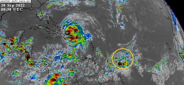
A stout wave presently located several hundred miles east of the Windward Islands is showing signs of sharpening, and based on modeling, will soon be encountering a more favorable region for development, and possibly a much more favorable region for development by week's end. This feature is not yet Invest tagged, but very well may be within the next day or two.
With this being peak season and the western Atlantic closer to land fairly primed for additional development, we are now starting a Forecast Lounge on this wave.
This will likely be given the Invest tag 98 later today or Wednesday. Overnight convection is flaring up well with continued sharpening of the axis.
(Invest 98L as of 9/20 12z) - Ciel
Invest 98L became a tropical depression overnight Sep 22nd and the title has been updated accordingly. Ian at 11PM EDT 9/23- Ciel
| MichaelA |
| (Weather Analyst) |
| Tue Sep 20 2022 08:08 AM |

|
|
|
Models are pretty scattered on this in the long run. CMC takes it into the Yucatan, ECWMF-operational takes it between Yucatan and Cuba, GFS brings it to the Florida keys, and NAVGEM has it follow Fiona’s track. We’ll have to keep watching this one.
| IsoFlame |
| (Weather Analyst) |
| Tue Sep 20 2022 09:39 AM |

|
|
|
Fuel for the fire:
SST's
| GeorgeN |
| (Weather Watcher) |
| Tue Sep 20 2022 02:13 PM |

|
|
|
I've been following the predicted path on Windy.com; and the GFS track just shifted from predicting the storm over Tampa (Thurs 29) to the storm out in Gulf (close to the ECMWF predicted location). Did the predictions just shift? This occurred right around 2:00PM EST.
I'm tracking this one intensely because I live in North Tampa and may be heading to Biloxi next week. I don't want to have a storm chasing me.
| IsoFlame |
| (Weather Analyst) |
| Tue Sep 20 2022 02:58 PM |
|
|
|
|
The relatives used to book trips to Biloxi in September to take advantage of casino perks, bu no more following the recent hyper-active GOMEX hurricane seasons. To go this time of year is gambling against the odds!

| Kraig |
| (Weather Hobbyist) |
| Tue Sep 20 2022 03:41 PM |

|
|
|
The 12z run of the euro just swung back to the FL peninsula just north of Tampa but as a much weaker storm than the current GFS run...This would drive an awful lot of water up into the bay!
| GeorgeN |
| (Weather Watcher) |
| Tue Sep 20 2022 04:21 PM |
|
|
|
|
Quote:
The 12z run of the euro just swung back to the FL peninsula just north of Tampa but as a much weaker storm than the current GFS run...This would drive an awful lot of water up into the bay!
I saw that change. Weird how the GFS and Euro switched to each other's previous estimates. I suspect this has something to do with when they are run. I'm waiting till week's end to make a "go/ no go" on this trip
.
MikeC
|
| (Admin) |
| Wed Sep 21 2022 06:47 AM |
|
|
This system has a few more days before it develops. Although once in the west Caribbean the upper air pattern for it is strikingly good on the models, so the intensity may be uncapped at least in that variable. Dry and land interaction may be the only thing holding it back. The models are shifting to basically somewhere in the Eastern Gulf, which could mean MS/AL/Panhandle or somewhere along the west coast of Florida. Although before anything has developed, I'd remain very cautions about inferring anything about exact track there. It'll likely get south of Grand Cayman and start turning north around then, if it goes over Cuba or through the Yucatan channel is unknown.
0GFZ currently has a landfall just west of Panama City Beach, Sep 30, Friday morning as a cat 4. This track will likely shift back and forth multiple times, potentially quite far one way or the other over the next week. So the only thing I can infer is the Keys and west Coast of Florida to Louisiana needs to watch this very closely.
0z EURO has a landfall Thursday morning in Naples after getting very close to Key West, as cat 3. After that crosses the state and exits somewhere around Melbourne then makes another landfall in Wilmington, NC.
0z Canadian ends in the Central Gulf on Sep 30th. (Which is a huge shift east from earlier where it wound up in the Bay of Campeche)
0z German Icon only goes out to the 28th, but it ends on the western tip of Cuba as a cat 3.
Remember these models are all over 5 days so not very reliable at this point for track OR intensity, especially for a system that has not developed yet and probably won't until it gets into the Caribbean in 2-3 days. Good for giving a sense of a good general area (being several states wide) to need to pay attention to.
The angle it which its coming from will making figuring out the exact track very difficult even very close to the landfall timeframe, especially if it winds up targeting the west coast of Florida. (See Hurricane Charley for an example of that) Timeframe is late next week for Gulf/Florida. (Thur-Sat depending on exactly where it goes)
In the meantime Canada will be dealing with a very strong transitioning Fiona (Equivalent pressure typical to a cat 4 when it arrives in Nova Scotia).
| cieldumort |
| (Moderator) |
| Thu Sep 22 2022 03:11 AM |
|
|
|
|
Invest 98L's surface center has arguably remained more over northernmost South America, than over the Caribbean, and this land interaction coupled with debilitating outflow from Hurricane Fiona have been preventing the trof from developing, thus far. However, with the continued pull to just north of west, along with Fiona moving away, the likelihood of tropical cyclogenesis is easily pegged at 70% within 2 days and 90% within 5 days.
But we have questions.
It appears that many models have initialized 98L a little too far over open water. This may result in a rightward track bias. There remains a possibility that 98L tracks further west than currently advertised by whatever consensus currently exists. This is not a baseline scenario, but can not be ruled out.
Additionally, operational GFS this season has proven to have a high development and intensification bias in the western Caribbean. Unsurprisingly, even early runs of GFS on 98L have predicted a sub-940hPa Major. While definitely far more realistic a possibility than earlier in the season, one could say likely, it does yet cast doubt on the aggressive runs GFS has put out so far, and also puts even more into question the forecast of a more right-leaning track, including the Florida peninsula, as a less robust cyclone may not pull so far to the right. Even if the system were to Major, if it doesn't major soon enough, this could still be more of a concern from Texas to the Florida panhandle than the Florida peninsula.
Realistically, this far out and without a solid cyclone yet to forecast off of, even Mexico is still in play, however unlikely.
These caveats aside, the baseline and more likely outcome is for the fledgling to really take off somewhere between the central and western to northwestern Caribbean in an environment of moderate to very low shear and high to very high ocean heat content, with long-range modeling still suggesting a tug into the central to eastern Gulf of Mexico.
Some Sep 22 0z runs
GFS - May have a reasonable initialization. Probably TD by late Thursday night/Friday morning. Tropical storm by Saturday night while in the central Caribbean. Hurricane by Monday morning in the northwestern Caribbean. Cat 2 or better on approach to northeastern/eastern Yucatan Tuesday morning (the 27th). Crosses northern Yucatan during the day Tuesday as high-end Tropical Storm to Hurricane. Becomes a sizeable and powerful Cat 2+ hurricane in the central Gulf mid to late next week on approach to Louisiana, with a landfall in central Louisiana early Sunday, October 2nd.
HMON - Looks to have initialized too much over open water. TD by later this morning or early afternoon (Thursday, 22nd). Tropical Storm by Sunday morning while in the west-central Caribbean. Hurricane by Monday morning in the northwestern Caribbean. End of this model's run as a Cat 2 on approach towards the northeastern Yucatan.
HWRF - Initialized a bit much northeast, over water and already organizing. Tropical Storm as of this hour in the extreme southern Caribbean, with the cyclone then seeming to struggle until it reaches the west-central Caribbean. Hurricane by midday Sunday in the western Caribbean. Majors in the northwestern Caribbean Monday morning. Cat 4 by Monday night. Deepening Cat 4+ near 20.5N 85W at the end of this model's run predawn Tuesday the 27th.
|
MikeC
|
| (Admin) |
| Thu Sep 22 2022 07:12 AM |
|
|
Morning Models
The 6z GFS gets over the Yucatan Peninsula and back over the open Gulf where it moves somewhat slowly and landfalls south of Lake Charles Sunday afternoon on October 2nd. The GFS Seems to be alone that far west. The 0z Canadian GEM (CMC) model takes it over Naples, FL this Coming Tuesday as a category 2 hurricane. The 0z Euro landfalls north of Tampa near Cedar key Thursday morning as a cat 3/4 hurricane. The UKMET and TVCN consensus (NHC is usually close to it) have it in the East Gulf generally toward the Florida panhandle.
Without a definite center to track and it being so close to south America, there's still a great deal of uncertainty right now, but GFS seems to be the outlier at the moment.
| GeorgeN |
| (Weather Watcher) |
| Thu Sep 22 2022 08:25 AM |
|
|
|
|
The Euro model just appeared on the charts, Now swinging West with the storm clipping the West edge of Cuba, going North then East, coming into Florida around Cedar Key on Thursday afternoon. It will probabaly be late this weekend before we see any definitive convergence of the models (maybe).
| IsoFlame |
| (Weather Analyst) |
| Thu Sep 22 2022 08:36 AM |
|
|
|
|
98-L hasn't developed a well-defined circulation (just yet) to track, and there is no mention of forward speed of the system (as a whole) in the NHC discussion. Sat loop suggests currently moving W/WNW at a pretty good pace while embedded in moderate/strong easterlies.
While I find it hard (ATM) to get on board with the most aggressive models forecasting rapid intensification to a Major 5+ days out, once (if) 98-L gets clear of land and in a lower shear environment while slowing over the high/deep available oceanic energy in the western Caribbean, in total agreement that impressive intensification will be likely.
| Kraig |
| (Weather Hobbyist) |
| Thu Sep 22 2022 08:59 AM |
|
|
|
|
Agreed...The outflow from Fiona seems to be holding 98L back for the time being, and that alone may be the thing that saves peninsular Florida and sends the potential storm further west into the central Gulf. I hope they keep sending at least one recon plane in a day to collect data, preferably a high altitude GIV to continue feeding some really great data into the models.
| cieldumort |
| (Moderator) |
| Thu Sep 22 2022 12:24 PM |
|
|
|
|
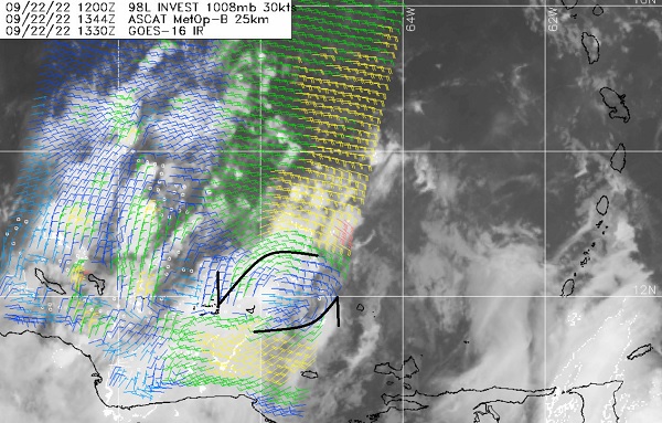
A nascent LLC can be seen in the most recent ASCAT pass from this 1344z this morning at approximately 11.8N 65.5W. This low-level spin was also discernible in select IR channels already over water predawn today, and looks to have become dominant, with the preexisting low level spin that was centered inland not nearly as obvious now, and appears to be getting entrained into this new 'center.' While elongated and not fully closed off, it looks solid enough for 98L to try to build on, and a tropical cyclone may be forming today.
|
MikeC
|
| (Admin) |
| Fri Sep 23 2022 01:10 AM |
|
|
0z models:
Trend here is SW Florida, but SLOW moving once landfall happens so it affects a lot of Florida. Rainfall totals are extreme.
GFS:
Clips W. Cuba as a cat 2/3 Monday night,
Landfall between Englewood and Venice, FL Wednesday morning cat 3/4. Moves very Slowly over Florida (extreme rainfall amounts). Exits Vero Beach Thursday midday. Loops back,. landfall near Hilton Head Island, on Friday night, then moves inland toward Columbia, SC.
Icon:
Moves over Cuba midday Tuesday, very clo0se or over Key West early Wednesday morning as a cat 2/3, Naples Midday Wednesday as a cat 2/3. Rides slowly up through Florida and Exits at Cape Canaveral midday friday.
CMC:
West cuba Monday night cat 2. Fort Myers, Cat 2/3 predawn Wednesday morning. Stalls over or just east of Tampa for most of Wednesday and thursday. Slides north, gets into Georgia Friday Afternoon.
| craigm |
| (Storm Tracker) |
| Fri Sep 23 2022 04:28 AM |

|
|
|
Quote:
0z models:
Trend here is SW Florida, but SLOW moving once landfall happens so it affects a lot of Florida. Rainfall totals are extreme.
GFS:
Clips W. Cuba as a cat 2/3 Monday night,
Landfall between Englewood and Venice, FL Wednesday morning cat 3/4. Moves very Slowly over Florida (extreme rainfall amounts). Exits Vero Beach Thursday midday. Loops back,. landfall near Hilton Head Island, on Friday night, then moves inland toward Columbia, SC.
Icon:
Moves over Cuba midday Tuesday, very clo0se or over Key West early Wednesday morning as a cat 2/3, Naples Midday Wednesday as a cat 2/3. Rides slowly up through Florida and Exits at Cape Canaveral midday friday.
CMC:
West cuba Monday night cat 2. Fort Myers, Cat 2/3 predawn Wednesday morning. Stalls over or just east of Tampa for most of Wednesday and thursday. Slides north, gets into Georgia Friday Afternoon.
Hope they are paying attention in the Keys being, at a minimum, on the dirty side of the storm or worse. Looking a lot like Charlie and Wima
| IsoFlame |
| (Weather Analyst) |
| Fri Sep 23 2022 07:07 AM |
|
|
|
|
Quote:Quote:
0z models:
Hope they are paying attention in the Keys being, at a minimum, on the dirty side of the storm or worse. Looking a lot like Charlie and Wima
...but slower (hence much wetter)
|
MikeC
|
| (Admin) |
| Fri Sep 23 2022 07:44 AM |
|
|
The 0z euro is slower than yesterday's 12z, crosses Cuba Tuesday morning as a cat 1, then arrives in southwest Florida, near Marco Island, early Wednesday instead of Tuesday night cat 1 . It moves quickly through the state and leaves near Fort Pierce. Then cliips the outer Banks and heads to Long Island.
6Z GFS clips Western Cuba as a Cat 3/4 late Monday night. Landfall near Bradenton as a cat 3 Wednesday afternoon. Would push water up Tampa Bay. Just south of Orlando Thursday Morning, gets into the Atlantic near Palm Bay Friday morning. (Spends all day Thursday OVER central Florida) loops over the Atlantic, Heads back southwest and landfalls near Jupiter (much weaker, TD) on Oct 5 then gets back into the gulf.
| MichaelA |
| (Weather Analyst) |
| Fri Sep 23 2022 07:47 AM |
|
|
|
|
Waiting for the 12Z model runs to see if there is more convergence. Still not clear until possibly 72 hours out. The entire peninsula of Florida should be paying close attention and checking storm preparations.
| Wingwiper |
| (Verified CFHC User) |
| Fri Sep 23 2022 08:46 AM |
|
|
|
"The entire peninsula of Florida should be paying close attention and checking storm preparations." As someone who rode out Charlie (that was supposed to go elsewhere) in my closet, that's the best advice of all.
| JMII |
| (Weather Master) |
| Fri Sep 23 2022 09:03 AM |

|
|
|
What was looking like an LA storm is now becoming more and more of a FL storm. Yesterday it was so disorganized I thought it might never gets its act together but this AM its looking more tropical. However it is being pushed hard by the tradewinds and limiting developement - the LLC is lagging way behind all the moisture to the west. A slow turn near Jamaica and clipping Cuba will be key points in its path to determine where in FL it ends up. Some of the models have it very far west to the point where it could be in the Big Bend area despite Port Charlotte being in the cross-hairs at this early stage. A tighter turn puts the Keys into the core. Going to monitor this closely.
Side note: our impact window install just finished last week so I no longer have to worry about putting multiple heavy panels onto a two story home. I'm getting too old for that nonsense.
| Lamar-Plant City |
| (Storm Tracker) |
| Fri Sep 23 2022 10:56 AM |

|
|
|
This one has me worried...I suffered a serious spinal cord injury in June...did 6 weeks in hospital and rehab and am confined to a wheelchair for the time being while we wait and see what heals. I have no ability to get into either of my vehicles. This storm seems to have my area in its site, so please keep us informed. My mom is 85 and alone and I can't take care of her like I usually would in this situation. This one has shades of Charlie all over it and it is hard to describe what Charlie did to my mom's house and neighborhood. Praying this one away!
| cieldumort |
| (Moderator) |
| Fri Sep 23 2022 02:38 PM |
|
|
|
|
TD9 is not winning the prettiest tropical depression award today. Persistently high northeasterly shear from Fiona's outflow continues to batter the barely-a-td today.
Unfortunately, this is not likely to last much beyond another day or two at most. By the time NINE reaches the western to northwestern Caribbean, shear could go from horribly hostile (present) to phenomenally favorable, just as the cyclone reaches some of the warmest and deeply warmest waters of the entire Atlantic basin for the entire stretch of this season.
There is yet a slim chance that NINE remains so impacted by the shear that it is not able to avail itself of the above mentioned stellar development environment as well and/or quickly as forecast. A slower ramp-up could make it less likely to recurve into the Florida peninsula. For now, modelling and indeed the official NHC forecast do not expect that outcome, keeping the entire state of Florida in the cyclone's path.
| dolfinatic |
| (Weather Guru) |
| Fri Sep 23 2022 04:03 PM |
|
|
 Not looking good. Time to get prepared.
| IsoFlame |
| (Weather Analyst) |
| Fri Sep 23 2022 05:06 PM |
|
|
|
|
Quote:
TD9 is not winning the prettiest tropical depression award today. Persistently high northeasterly shear from Fiona's outflow continues to batter the barely-a-td today.
Unfortunately, this is not likely to last much beyond another day or two at most. By the time NINE reaches the western to northwestern Caribbean, shear could go from horribly hostile (present) to phenomenally favorable, just as the cyclone reaches some of the warmest and deeply warmest waters of the entire Atlantic basin for the entire stretch of this season.
There is yet a slim chance that NINE remains so impacted by the shear that it is not able to avail itself of the above mentioned stellar development environment as well and/or quickly as forecast. A slower ramp-up could make it less likely to recurve into the Florida peninsula. For now, modelling and indeed the official NHC forecast do not expect that outcome, keeping the entire state of Florida in the cyclone's path.
A weaker (Cat 1/2) Ian, further west and a bit slower, based on last GFS suggesting the frontal trough will influence but not eject a rapidly intensifying hurricane NE across the peninsula (ala Wilma). A brief slowing, or even stall, over the east/central GOMEX off Tampa Bay allowing SE/S tropical surge to dumping 8-12" will be an issue for many saturated parts of central Florida but isn't an issue for my east central Florida location running a wet season deficit of nearly 7" I'll take a good soaking as long as the feeder spin ups are limited.
| MichaelA |
| (Weather Analyst) |
| Fri Sep 23 2022 05:13 PM |
|
|
|
|
The 12Z models seem to show a slight westward shift with landfall between Naples and Apalachicola. Several skirt the coast before reaching the Big Bend area with the GFS showing a stall or small loop before landfall near St. Marks. The 5PM advisory nudges the track slightly westward with a landfall near Sarasota. Of course, this will change east or west with each advisory until it gets to within 72 hours of landfall.
| OrlandoDan |
| (Weather Master) |
| Fri Sep 23 2022 05:58 PM |

|
|
|
Orlando is on the dirty side. Let's all keep an eye on this one. The upper level synaptic conditions will drive the direction
| MichaelA |
| (Weather Analyst) |
| Fri Sep 23 2022 08:45 PM |
|
|
|
|
The 18Z GFS nudges a little more westward and the 18Z HMON indicates a landfall near Cedar Key. Still waiting on the 18Z HWRF.
*Edit* The 18Z HWRF is in agreement with the 18Z GFS.
| JMII |
| (Weather Master) |
| Fri Sep 23 2022 09:15 PM |
|
|
|
|
Two issues causing the confusion on TD9 / Ian future track:
1) Where will the true center form? East where the LLC is currently located or west where the moisture center is and the direction the shear wants it to go.
2) How strong will the front moving over the NE US will be in two days after the run across Cuba? A weak front draws Ian NE across FL, where as a strong front keeps Ian in the gulf.
This one is going to be dicey for awhile. Model guidance covers a wide range of possibilities from as far east as the western Bahamas to as far west as the FL/AL boarder. Of course the official forecast (for now) is right down the middle near Sarasota. The path is very Charley-like
 the upper level pattern ahead will allow for intensification once it consolidates, so this could spin up quickly once it gets into that more favorable environment.
|
MikeC
|
| (Admin) |
| Fri Sep 23 2022 09:41 PM |
|
|
18z GFS doesn't seem to have a great handle on the short term with TD9, but it's still worthwhile for general overview. A lot is going to depend on when the north turn begins and where the center forms now that shear will start to relax tomorrow.
The TVCN was at Bradenton earlier today and now has moved back to Englewood (then over Orlando and out over Volusia/Flagler)
I'm waiting on the storm to get out of its current shear situation because I think the short term errors are larger in the models.
| cieldumort |
| (Moderator) |
| Sat Sep 24 2022 01:47 AM |
|
|
|
|
NINE (Now Ian) has begun to avail itself of the much more favorable environment for development and potential Rapid Intensification, and the favorable conditions only look to improve from here, possibly off and on - or even mostly on - all the way to Florida, save land interaction.
This is not the scenario anyone wanted to see unfolding, but this is what looks to be the case with probably better than 90% certainty.
Here are my personal lifetime max intensity odds for Ian.
Low-Mid Tropical Storm < 1%
High-End Tropical Storm 2%
Cat 1 Hurricane 3%
Cat 2 Hurricane 15%
Cat 3 Hurricane 30%
Cat 4 Hurricane 35%
Cat 5 Hurricane 15%
Once the synoptic and meso scale features start to come into better focus, I might place an early best guess on landfall(s) intensity, but suffice it to say, this season will probably be the last time we ever see the name Ian used again.
| IsoFlame |
| (Weather Analyst) |
| Sat Sep 24 2022 06:27 AM |
|
|
|
|
Organizing pre-dawn Saturday morning burst of convection , banding close to the LLC.
| IsoFlame |
| (Weather Analyst) |
| Sat Sep 24 2022 06:57 AM |
|
|
|
|
5AM cone suggests possible Cat 2/3 very near the gut of Tampa Bay. Last major to hit was 1921 Tampa Bay/Tarpon Springs Hurricane
My uncle built his house in St. Pete on "high ground" (7' above Bay level) on Snell Island in the 1960's and lived there until his death in the late 2000's. Several tropical storms and a weak hurricane or two over the 40 year period submerged his dock, sea wall and yard, flooded many nearby homes and made roads impassible. But sea water never into the house.
If center of Ian tracks just to the left of the Bay entrance, striking or glancing off Pinellas peninsula, the storm surge could be historic.
|
MikeC
|
| (Admin) |
| Sat Sep 24 2022 09:02 AM |
|
|
morning models, note most initialized too far north based on recon reports.
6z gfs:
Clips western Cuba Tuesday morning as a cat 3.
Landfalls east of Apalachicola as a cat 1/2 (weakens with shear before landfall)
0z euro
notably correctly picked up on the SW jog this morning
Cat 1 hurricane just west of Grand Cayman Monday night
Crosses Cuba as a cat 1 just west of Havana.
Cat 2/3 landfall near Englewood late Wednesday afternoon. Moves slowly over the state and over jacksonville early friday morning then zooms inland Northwest over Georgia.
And there you have the two camps, split the difference is closer to Crystal River or Cedar Key, but weighted closer to Tampa, which is where the official track is. I expect some changes, but the general range is Napes to Apalachicola still.
| Marknole |
| (Weather Watcher) |
| Sat Sep 24 2022 09:52 AM |

|
|
|
"Above-average uncertainty in the forecast track." So the Euro (and ensembles) have been consistent with SW (or more recently West Central) FL, with the (new and tweaked for the 2022 hurricane season!?) GFS/ensembles staying offshore and eventually targeting Apalachee Bay. There is a history of "Steinhatchee Storms", and Ian looks like a prime candidate. This could be a best-case scenario with the center striking a swampy, lightly-populated area that is familiar with high storm surge. It would also likely be weakening due to expected wind shear that Mike mentioned.
| JMII |
| (Weather Master) |
| Sat Sep 24 2022 09:59 AM |
|
|
|
|
Quote:
morning models, note most initialized too far north based on recon reports.
6z gfs:
Clips western Cuba Tuesday morning as a cat 3.
Landfalls east of Apalachicola as a cat 1/2 (weakens with shear before landfall)
That model run keeps it west enough that direct coastal effects wouldn't be too bad if it stays small. It is also further west then the previous run.
Ian is building, there is a lot of thunderstorms bubbling up and its even developing outflow channels. However recon didn't find much in the way of winds yet. Its a bit of a jumble but all the ingredients are there, its just needs time.
| MichaelA |
| (Weather Analyst) |
| Sat Sep 24 2022 11:45 AM |
|
|
|
|
The 11AM discussion bumps the intensity up a bit before landfall and nudges the forecast track a bit more westward with landfall near Crystal River. If Ian remains offshore from Tampa Bay, that will lessen the impact there. If Ian does follow that track, the Nature Coast could suffer a catastrophic storm surge. The models continue to shift a bit westward with landfalls from Crystal River to Apalachicola. The panhandle west of Apalachicola doesn’t need another major hurricane strike.
| Southern4sure |
| (Weather Guru) |
| Sat Sep 24 2022 12:13 PM |

|
|
|
This 11 am discussion has Ian over my house at the 120H forecast position. I swear Ian is coming down my street…lol.
We are saturated from the daily rains and all our ponds are full. I’m not in a flood zone but I’m concerned with the amount of rain we will get and what it will do to the area.
| GeorgeN |
| (Weather Watcher) |
| Sat Sep 24 2022 02:25 PM |
|
|
|
|
Quote:
This 11 am discussion has Ian over my house at the 120H forecast position. I swear Ian is coming down my street…lol.
We are saturated from the daily rains and all our ponds are full. I’m not in a flood zone but I’m concerned with the amount of rain we will get and what it will do to the area.
The 2PM is more of the same despite a continued drift to the West. The Euro has drifted from its original landfall into the SouthWest portion of Florida to a more mid Florida entry. Meanwhile the GFS mean keeps drifting West along the Florida panhandle. The wide spread between the two is probabaly why the NHC is just recycling the previous track. This may be a good sign for those in the center of Florida, perhaps even for the whole state. Meanwhile, I've heard stories of people being extremely aggressive in my local grocery stores. The NHC track is again causing widespread panic without providing much useful information. I'm curious as to why the ECMF long track model hasn't been run since early yesterday. At least I can't see it plotted beyond Cuba.
|
MikeC
|
| (Admin) |
| Sat Sep 24 2022 03:36 PM |
|
|
There are two model camps
GFS/CMC is over toward Destin
Euro/UKMET/Icon is peninsula from Tampa (UK/Euro) to Icon, which is closer to the the big bend.
The TVCN consensus is around Apalachicola, which may be too much because of the high spread in the afternoon models in general
The position of the storm could change based on recon reports,but the 0z run tonight will be the first one with high altitude recon data which should help alleviate the spread. The center may be moving more north today based on the recon plane out their right now, but until past Jamaica its probably going to be in flux.
12z and 0z Euro go out the full distance, 6/18z do not, which would explain the plot only to Cuba.
Basically the entire cone is valid for the storm. Do not take any one model as gospel.
| cieldumort |
| (Moderator) |
| Sat Sep 24 2022 03:38 PM |
|
|
|
|
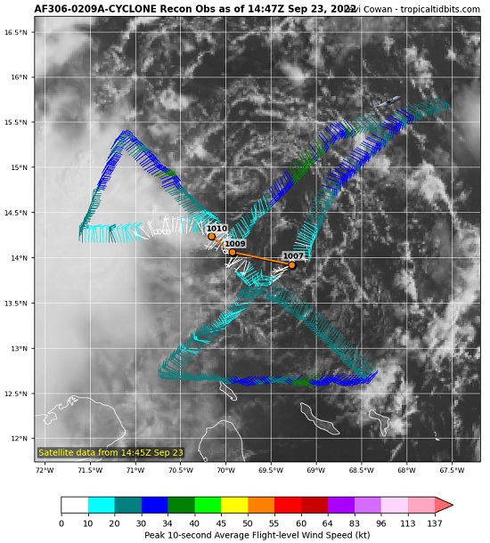
Recon, something we did not have much benefit of the past 48 hours as flights were focusing on Fiona, has spent a great deal of time in Ian today, and the data is significant.
The first thing of note, is that Ian is rather troffy, with possibly still multiple swirls, or "centers," old and new, rotating about a midpoint of the troffy-storm. In addition, it still seems be feeling the push possibly a little bit more southward than largely forecast by the narrow ridge to its north. Finally, the pressure does not yet seem to be falling, and winds are not picking up.
All the above taken together casts further doubt on the reliability of the near unanimous model consensus of a direct Florida west coast landfall. The minority reports, the outliers initially weaker and then further left (west) in the long-range, clearly have some validity.
In fact, there has only been one VDM so far today, from 1042z, predawn and many hours ago, that fixed way down at 13.54N 74.58W, and on its own did not make a compelling case for tropical storm intensity.
Quote:
A. Time of Center Fix: 24th day of the month at 10:42:29Z
B. Center Fix Coordinates: 13.54N 74.58W
D. Minimum Sea Level Pressure: 1006mb (29.71 inHg)
L. Estimated (by SFMR or visually) Maximum Surface Wind Outbound: 32kts (36.8mph)
M. Location & Time of the Estimated Maximum Surface Wind Outbound: 134 nautical miles (154 statute miles) to the NNE (30°) of center fix at 11:16:28Z
Q. Maximum Flight Level Temp & Pressure Altitude Inside Eye: 19°C (66°F) at a pressure alt. of 1,541m (5,056ft)
R. Dewpoint Temp (collected at same location as temp inside eye): 18°C (64°F)
S. Fix Determined By: Penetration and Wind
Remarks Section:
Maximum Flight Level Wind: 31kts (~ 35.7mph) which was observed 138 nautical miles (159 statute miles) to the NNE (30°) from the flight level center at 11:17:18Z
Maximum Flight Level Temp: 19°C (66°F) which was observed 12 nautical miles (14 statute miles) to the NNE (30°) from the flight level center
0z models out later tonight may respond in meaningful way. Track and intensity remain in play, particularly track, as Ian is still more likely than not to become a Major. But a Florida peninsula landfall, maybe not so locked in. We can certainly hope not, for the probable strength and size of Ian around that time could be devastating for locations such as the Keys and Tampa.
| GeorgeN |
| (Weather Watcher) |
| Sat Sep 24 2022 03:56 PM |
|
|
|
|
Quote:
Recon, something we did not have much benefit of the past 48 hours as flights were focusing on Fiona, has spent a great deal of time in Ian today, and the data is significant.
.
Agreed. Recon will be a big factor in nailing down a better starting position for the Euro models. So far, this type of storm has been problematic for the Euro model as it really requires a good starting point/storm center. This has always been the Euro's Achilles's heel. Not to say I'm a big GFS fan, but it has been reacting to the Westerly drift and disorganized center with less erratic plot changes.
I see the ECMF plot has finally popped up on the SWFMD tracks. Now showing landfall North of Tampa in the Cedar Key region.
| cieldumort |
| (Moderator) |
| Sat Sep 24 2022 04:41 PM |
|
|
|
|
Most recent VDM suggests Ian is still attempting to consolidate a stable center and has not gotten any stronger.
Quote:
Product: Air Force Vortex Message (URNT12 KNHC)
Transmitted: 24th day of the month at 20:21Z
Agency: United States Air Force
Aircraft: Lockheed WC-130J Hercules with reg. number AF97-5303
Storm Name: Ian
Storm Number & Year: 09 in 2022 (flight in the North Atlantic basin)
Mission Number: 4
Observation Number: 23
A. Time of Center Fix: 24th day of the month at 19:42:40Z
B. Center Fix Coordinates: 14.37N 76.77W
D. Minimum Sea Level Pressure: 1007mb (29.74 inHg)
H. Estimated (by SFMR or visually) Maximum Surface Wind Inbound: 22kts (25.3mph)
I. Location & Time of the Estimated Maximum Surface Wind Inbound: 9 nautical miles to the WSW (245°) of center fix at 19:39:30Z
L. Estimated (by SFMR or visually) Maximum Surface Wind Outbound: 25kts (28.8mph)
M. Location & Time of the Estimated Maximum Surface Wind Outbound: 1 nautical miles to the NE (37°) of center fix at 19:43:00Z
P. Maximum Flight Level Temp & Pressure Altitude Outside Eye: 17°C (63°F) at a pressure alt. of 1,525m (5,003ft)
Q. Maximum Flight Level Temp & Pressure Altitude Inside Eye: 18°C (64°F) at a pressure alt. of 1,520m (4,987ft)
Remarks Section:
Maximum Flight Level Wind: 44kts (~ 50.6mph) which was observed 56 nautical miles (64 statute miles) to the NW (320°) from the flight level center at 19:04:30Z
Maximum Flight Level Temp: 18°C (64°F) which was observed 10 nautical miles (12 statute miles) to the WSW (245°) from the flight level center
|
MikeC
|
| (Admin) |
| Sat Sep 24 2022 05:43 PM |
|
|
18z Icon shifts right from to a Cat 3 landfall just south of Venice, FL last model run had it at Cedar key at 12z.
18z GFS starts off too far south based on recon, but still manages to stay east of the 12z, but landfalls only about 35-40 miles east of the 12z position in the panhandle. It rapidly weakens from shear as it approaches the panhandle.
| cieldumort |
| (Moderator) |
| Sat Sep 24 2022 05:58 PM |
|
|
|
|
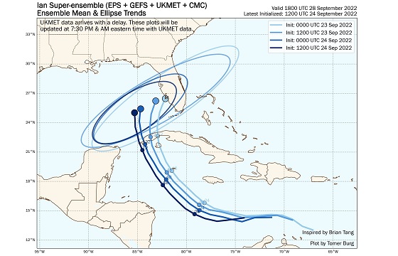
Tomer Burg's Super-ensemble has continued its shift west (left) with the most recent composite, 12z. Will be very informative to see how the 0z coming up looks.
| IsoFlame |
| (Weather Analyst) |
| Sat Sep 24 2022 08:15 PM |
|
|
|
|
Ian's rag-a-muffin lack of consolidation/strengthening today and ongoing shear widened the cone with two spaghetti plot camps: FL panhandle/Big Bend versus Tampa/Port Charlotte.
Lack of strengthening during daylight hours today due to ongoing shear and less than stellar organization should not let anyone in the cone let their guard down. Westward shift of forecast track = less (if any) significant interaction with western Cuba, and a delayed US landfall (by a day) = more time over seasonal max SST's in the NW Caribbean and eastern GOMEX. with increasingly favorable conditions next 48 hours,
At some point late tomorrow into Monday when rapid intensification is well underway, models should gorge on rich upstream data from extensive atmospheric parameter sampling, reaching much better consensus.
..
|
MikeC
|
| (Admin) |
| Sun Sep 25 2022 06:53 AM |
|
|
The model split continues overnight. GFS, HWRF are in the panhandle west of Panama City Beach (near Seaside) -- 6z moved to Panama City Beach itself . CMC is near Cedar Key. UKMET, Icon, and the Euro are now south of Tampa. (All shifted right some, although the icon shifted the most right).
The Current forecast splits the difference, and add onto that uncertainty about the center of Ian persists as it looks like the more northern area (under the convection) is starting to win out.
"With the cross-track spreading remaining between 200-220 n mi at days 4 and 5, it cannot be overstated that significant uncertainty remains in Ian's long-range prediction. "
This is the story for this morning. The entire cone still needs to take this seriously.
At least the MLC looks to be around 15.5N this morning, so I expect it to consolidate there, the south one seemed like a red herring. LLC may not be there yet, recon has that at 14.9N 79.4W, i expect it'll slide up to match the MLC fairly soon.
| MichaelA |
| (Weather Analyst) |
| Sun Sep 25 2022 07:05 AM |
|
|
|
|
Yes, the 00Z model runs took a slight eastward shift again. With more Gulfstream IV data becoming available and if Ian can get vertical and begin the predicted rapid intensification, I would assume the models would begin to converge. Time will tell, and no one in the cone should relax just yet.
|
MikeC
|
| (Admin) |
| Sun Sep 25 2022 08:02 AM |
|
|
Model uncertainty this morning
|
MikeC
|
| (Admin) |
| Sun Sep 25 2022 08:52 AM |
|
|
Lounge thoughts is that the Consensus will settle closer to Cedar Key or Steinhatchee, but the Euro (even 6z now is south of Tampa) with a move north. So it looks like it could get uncomfortably close to Tampa, potentially slide along just offshore (with the dirty side over land) and eventually landfall in the Big Bend or at/around Cedar Key.
This would be pretty bad for surge if that happened from at least Tampa up, but hoping it stays far enough west to avoid the worst of that.
| JMII |
| (Weather Master) |
| Sun Sep 25 2022 09:06 AM |
|
|
|
|
Not what I expected this AM in terms of organization - Ian’s a mess. Reading the NHC discussion the lack of a true center is causing issues with determining strength and direction. Long term model guidance seems plagued by “when†leading to confusion over where. Slower motion favorites a N track while faster movement would allow the turn E into Tampa to occur. All models point to a ramp up into a major ‘cane but you wouldn’t know that by the current satellite imagery.
| IsoFlame |
| (Weather Analyst) |
| Sun Sep 25 2022 01:01 PM |
|
|
|
|
Quote:
Not what I expected this AM in terms of organization - Ian’s a mess. Reading the NHC discussion the lack of a true center is causing issues with determining strength and direction. Long term model guidance seems plagued by “when†leading to confusion over where. Slower motion favorites a N track while faster movement would allow the turn E into Tampa to occur. All models point to a ramp up into a major ‘cane but you wouldn’t know that by the current satellite imagery.
I've had the same thoughts watching NINE and TS Ian to this point. However, at noon satellite imagery illustrates possible stacking of circulation and influx of banding deep convection NE of the center, leading me to believe that Ian's unimpressive organization so far is about to dramatically change this afternoon through the evening. Next 48-60 hours we could witness an exponential (Camille-like?) ramp-up in intensity to 140 mph as NHC forecast and intensity models suggest.
Even though the cone shifted west away from Tampa Bay region today, I hope newcomers to the Bay area or those that did not have grandparents that lived there, are preparing for flooding rainfall and a near historic storm surge potentially approaching (OR EXCEEDING) 10 feet.
Even though it is a beautiful late September weekend and it may be hard to grasp how dramaticlly conditions may go downhill early Wednesday as Ian nears, PAY VERY CLOSE ATTENTION TO THE OFFICIAL FORECAST AND ALL UPCOMING WARNINGS when Ian's organization dramatically improves, allowing modeling to narrow down ultimate track/intensity and Florida west coast landfall.
|
MikeC
|
| (Admin) |
| Sun Sep 25 2022 04:36 PM |
|
|
Ian's 12z models all shifted east, including the euro which has increased the risk for the Florida peninsula tonight. However the system has failed to get organized much today, but still is primed to do so soon. It's moving NW now it looks like.
Even the TVCN consensus shifted right today, so 5PM update should have a decent shift 25-35 mile east.
| MichaelA |
| (Weather Analyst) |
| Sun Sep 25 2022 07:41 PM |
|
|
|
|
The 18Z GFS has shifted eastward again indicating a close brush to Tampa Bay then continuing into the Big Bend. Currently waiting for the other 18Z model runs. Ian did not intensify today, but the NHC consensus still calls for Cat 3 intensity near Cuba’s western tip on Monday. Southwesterly shear is expected to weaken the storm beginning Tuesday into Wednesday leading to a weakening but expanding storm. That could mean an extended time period of nasty weather along the entire west coast of Florida. Keep watching and making your storm preparations.
*Edit* The 18Z HMON nudged a bit East and the 18Z HWRF nudged a bit West. It’s still a crap shoot.
| Keith B |
| (Weather Hobbyist) |
| Sun Sep 25 2022 10:31 PM |
| Attachment |
|
|
Admin,
Is it possible to have the viewing of information be screen width and not beyond, please?
I have attached my screen pic for reference.
Thank you.
| MichaelA |
| (Weather Analyst) |
| Sun Sep 25 2022 11:17 PM |
|
|
|
|
The 11 PM track guidance shifts slightly eastward again, bringing the center of Ian at Cat 2/3 to about 60 miles west of the mouth of Tampa Bay at 8 PM Wednesday. Model runs have been trending eastward all day today, and I expect that trend might continue in the short term. Be vigilant and make your preparations tomorrow and Tuesday.
| GeorgeN |
| (Weather Watcher) |
| Mon Sep 26 2022 09:54 AM |
|
|
|
|
The 8AM is similar to last night, though the Euro appears to be shifting West to follow the GFS. For some reason, the UKMET shows landfall around Venice, with exit around Jacksonville. I'm not sure why it departed from the other plots, but this is causing the NHC track to skew East. I'm sure it's a bad plot, but I prefer to be on the good side, so I'm rooting for the UKMET.
| JMII |
| (Weather Master) |
| Mon Sep 26 2022 10:34 AM |
|
|
|
|
Ian is, as predicted, getting its act together. Outflow is good in all quadrants, the core is developing. The big change I see in the NHC forecast is this slower motion (with more surge) and a shear inducted weakening in the end. Several forecasts ago we were looking at a curve across the state and out to sea over the east coast. Now it could just move into GA and die there.
The problem continues to be this follow-the-coast type track which puts a large area along the west coast to the panhandle in the danger zone. If the wind field expands the entire west coast of FL could experience hurricane force winds. In the end the size of the storm may be more of an issue then where exactly it makes landfall. A small but strong storm that stays just offshore then weakens before landfall is the best case situation. The model diversions start after moving N of Key West, so once it cross Cuba hopefully the models get a better grasp on things and we see a narrowing of possibilities. The approach angle means small difference in the track could make big differences in the future, or it may not matter since so much of the coast will be effected. On the flip side the core staying offshore just enough would only generate TS winds onshore.
| OrlandoDan |
| (Weather Master) |
| Mon Sep 26 2022 11:01 AM |
|
|
|
|
11 am adjusted the track slightly east again.
| pongolo |
| (Registered User) |
| Mon Sep 26 2022 11:16 AM |
|
|
I'm pretty sure the issue is the image in post #114244 since it's very wide and it makes all posts be much wider than typical.
| MichaelA |
| (Weather Analyst) |
| Mon Sep 26 2022 11:26 AM |
|
|
|
|
Now looking to be possibly within 30 miles of the Pinellas County coastline. Not a good scenario if that verifies.
| GeorgeN |
| (Weather Watcher) |
| Mon Sep 26 2022 11:29 AM |
|
|
|
|
Does anyone know why the update frequency of the ECMWF model on SWFMD seems to be 4 times per day? I know it is supposed to be twice daily like UKMET, but the SWFMD plots appear to be more often. Are they running their own? Just curious to know.
Thanks to cieldumort for showing me Tomer's site. Much cleaner plots than the others.
Quote:
Does anyone know why the update frequency of the ECMWF model on SWFMD seems to be 4 times per day? I know it is supposed to be twice daily like UKMET, but the SWFMD plots appear to be more often. Are they running their own? Just curious to know.
Thanks to cieldumort for showing me Tomer's site. Much cleaner plots than the others.
Delighted to share Tomer's site. Some of the very best out there IMHO. The EURO is run 4 times a day, although the 06 and 18 are rapid runs, and only out to 90 hours rather than 240. - Ciel
|
MikeC
|
| (Admin) |
| Mon Sep 26 2022 01:14 PM |
|
|
SFWMD updates all the models it can every 6 hours, some of them are still the older runs
12Z GFS Is a direct hit on Tampa as a strong cat 3.
| IsoFlame |
| (Weather Analyst) |
| Mon Sep 26 2022 01:50 PM |
|
|
|
|
Quote:
SFWMD updates all the models it can every 6 hours, some of them are still the older runs
12Z GFS Is a direct hit on Tampa as a strong cat 3.
I can't imagine many scenarios worse than a brief/slow jog to the ENE as the GFS suggested. It would put the Bay and Pinellas on the right front quadrant of a strong, slow moving cat 3 for 6-8 hours (maybe even 10-12) starting late night Wednesday into much of Thursday.
| JMII |
| (Weather Master) |
| Mon Sep 26 2022 03:22 PM |
|
|
|
|
Quote:
I can't imagine many scenarios worse than a brief/slow jog to the ENE as the GFS suggested. It would put the Bay and Pinellas on the right front quadrant of a strong, slow moving cat 3 for 6-8 hours (maybe even 10-12) starting late night Wednesday into much of Thursday.
The only good news with the slower motion is that increases the chances Ian has of sucking in dry air and encountering shear as the global models show unfavorable environmental conditions later on this week. However that scenario only plays out if Ian stays offshore moving N then coming in near the Big Bend region. If it turns ENE sooner into Tampa it will be going full tilt but then surge wouldn't have a chance to pile up as much.
As has been the case for the last few days the models are split between the E turn and N stall out - so for now the NHC is showing a middle option guesstimate. The models yesterday were more N but today they have swung back E. I still think the bigger factor is the wind field since a compact storm would keep hurricane force winds offshore until it makes landfall. Currently hurricane force winds only extend out 35 miles from the center.
| IsoFlame |
| (Weather Analyst) |
| Mon Sep 26 2022 03:59 PM |
|
|
|
|
Not much lightning currently around the core of Ian- more over S Fla in the afternoon t-storms:
lightning mapper
There should be a good light show tonight in deep convection wrapping around the center as Ian continues to wind up, and the eye clears out.
| Keith B |
| (Weather Hobbyist) |
| Mon Sep 26 2022 04:18 PM |
|
|
Thank you admin for adjusting the screen. Much easier to read. : )
| Psyber |
| (Storm Tracker) |
| Mon Sep 26 2022 04:18 PM |

|
|
|
Quote:Quote:
I can't imagine many scenarios worse than a brief/slow jog to the ENE as the GFS suggested. It would put the Bay and Pinellas on the right front quadrant of a strong, slow moving cat 3 for 6-8 hours (maybe even 10-12) starting late night Wednesday into much of Thursday.
The only good news with the slower motion is that increases the chances Ian has of sucking in dry air and encountering shear as the global models show unfavorable environmental conditions later on this week. However that scenario only plays out if Ian stays offshore moving N then coming in near the Big Bend region. If it turns ENE sooner into Tampa it will be going full tilt but then surge wouldn't have a chance to pile up as much.
Sucking dry air? From where? The eye appears to be going overland in the next day however the W/W NW side of the storm will stay over HOT water for the entire time it's over Cuba, no matter if it is inland a bit or if it comes in around the tip that points to Cancun.. Storms usually go to Cuba to die, but that's when they're going West and prolonged over the mountains of Cuba.
They don't go there to die when they're basically going north over some of the lowest sea level parts on what appears to be the thinnest strip of land in all of Cuba. Even though Ian is going slow, it won't even be over Cuba longer than a very small period of time versus a lot of "normal" tracks.
If it weakens from Cuba, it will be tiny compared to normal...that is to say that there are a lot of people looking at this like "yeeeap, heading over, Cuba, going to drop all it's energy and turn it into a TD, just like most times!). This isn't that, and some like me see it getting WORSE even though it's over land because it'll still be taking in warm water out of the Yucatan Channel the entire time it's over lCuba until it gets into the Gulf. At that point, it possibly EXPLODES into an H4...maybe FIVE within a day and a half..
The high that is forecast to affect the storm when it's nearly on Florida will most definitely weaken it, but that's after a lot of Gulf.
Lastly, I've said it before, and I'll say it again. The modelling doesn't seem to EVER give enough consideration to SST's. The WORST air pressure this is "forecast" as having is 950ish? I find that VERY hard to believe. Seeing as how every inch of where this storm could go is 30C-34C, they're YET AGAIN ignoring the fact that WHEN Ian gets a defined eyewall(could be now/south of Cuba for all the data we can see), the storm is likely going to have SCARY hot water to spawn more outlying storms from. If it gets that hot water for very long before the high moving in from the North hit's it, the storm is going to explode, and I don't see any modelling that currently captures that at this point. Heck, we could see the high bumping Ian further out into the Gulf for a longer period of time while the low and high duke it out to see who is stronger. *sheug*.
The day I meet a Met who takes SST's as serious as he/she should, I'm going to buy them a drink.
| IsoFlame |
| (Weather Analyst) |
| Mon Sep 26 2022 05:47 PM |
|
|
|
|
Last few hours of daylight vis loop shows a small eye emerging:
GOES 16 GeoColor Visible satellite loop
Intensity only ramps up from here next 36 hrs. Some guide\ance suggests the forward speed will slow Wednesday afternoon and a brief stall for 24 hours is possible just offshore SE of St. Pete Beach. If this plays out, a long duration storm surge approaching 12' could slosh up Tampa Bay. Add 3-5" (locally more) of rain and there will be catastrophic flooding throughout the Bay's watershed..
Storm surge warnings now extend from TB all the way down to Everglades City.
| Kraig |
| (Weather Hobbyist) |
| Mon Sep 26 2022 05:49 PM |
| Attachment |
|
|
|
|
Quote:
Sucking dry air? From where?
Here is the 700-300mb and 500mb Rh for Wednesday afternoon.....There's more than a little dry air available.
[image]https://www.tropicaltidbits.com/analysis/models/?model=gfs®ion=watl&pkg=midRH&runtime=2022092612&fh=24[/image]
| Robert |
| (Weather Analyst) |
| Mon Sep 26 2022 05:56 PM |

|
|
|
With slow down, and bad conditions north, dry air ect, why not head east with it and go for better conditions.. just saying maybe north then North north east early, putting south Florida at risk... just speculation, only EEMN ensemble member supporting that today.
| Psyber |
| (Storm Tracker) |
| Mon Sep 26 2022 05:59 PM |
|
|
|
|
Quote:
SFWMD updates all the models it can every 6 hours, some of them are still the older runs
12Z GFS Is a direct hit on Tampa as a strong cat 3.
See, other than that, most models aren't painting that sort of intensification outlasting the high coming from the Southwest, and I don't believe them,
There's too much hot water and time for Ian to grow for it to just shed possibly 70MPH of strength.
What the Mets on all the tv stations should be screaming about is some very intensive storm surge that even if the stop slows, is going to keep moving, even if the intensification drops. How many times are we going to see "Whew...storm's an H1 but wait...10 footers just took the entire shoreline out in (insert place that thinks billions of tons of windswept water just stops if the wind slows).
| Psyber |
| (Storm Tracker) |
| Mon Sep 26 2022 06:02 PM |
|
|
|
|
Quote:Quote:
Sucking dry air? From where?
Here is the 700-300mb and 500mb Rh for Wednesday afternoon.....There's more than a little dry air available.
[image]https://www.tropicaltidbits.com/analysis/models/?model=gfs®ion=watl&pkg=midRH&runtime=2022092612&fh=24[/image]
He's talking about it over Cuba tonight, not when it hits Florida in two or so days. Reads the whole post pleases. It has and is going to have more moisture than it needs for most of the next 2+ days.
Needs to be said that it's an H2 despite that jenky-looking eyewall. Pressure down to 972, and they think this is going to make a fairly decent walk across the Gulf and end up at like 960 when it gets to the other side? Ummm...
| JMII |
| (Weather Master) |
| Mon Sep 26 2022 06:30 PM |
|
|
|
|
Quote:
He's talking about it over Cuba tonight, not when it hits Florida in two or so days.
Incorrect - I said later on this week. Specifically referring to landfall in the big bend.
A storm needs more then just warm water, case in point it struggled for the last 3 days due to wind shear. Similar shear is forecast when or if Ian makes it far enough north. The NHC shows at that in 72 hours (2pm Thursday) it’s located at Clearwater Beach with 85 MPH winds.
| Psyber |
| (Storm Tracker) |
| Mon Sep 26 2022 07:03 PM |
|
|
|
|
Quote:Quote:
He's talking about it over Cuba tonight, not when it hits Florida in two or so days.
Incorrect - I said later on this week. Specifically referring to landfall in the big bend.
A storm needs more then just warm water, case in point it struggled for the last 3 days due to wind shear. Similar shear is forecast when or if Ian makes it far enough north. The NHC shows at that in 72 hours (2pm Thursday) it’s located at Clearwater Beach with 85 MPH winds.
The storm is getting everything it needs and, like all these "bizarre storms," has the potential to surprise people more than just looking at flat data that we consider for storms. It just did a rapid increase of intensity in less than three hours of 15MPH, which was not forecasted by the NHC. (an H2 before hitting Cuba). It wasn't supposed to be a hurricane before Cuba in a lot of forecasts two days ago, and now we have an intensifying H2 that doesn't even have a visual eyewall.
The point is that I'm aware of and can see the wind sheer ripping bands off the storm. I can also see that it's organizing itself quite rapidly despite that wind sheer. I suppose I messed up in my assumption of him meaning the second high that's coming later that hopefully saves Florida but then again, most people on here (sorry, don't deny it I've been watching it since being here for Katrina and am surprised my tongue hasn't totally been bit off) that most people don't give a crap about a storm until it starts to threaten the continental United States. Puerto Rico hadn't even gotten close to being fixed from Maria and Irma before Fiona this year. Their dead were measured in the thousands when they get hit in 2017, a number that would make people drop dead from the shock alone if it happened on the mainland. After they buried the dead that fell dead in shock, they'd send so much physical and financial help that they'd have people fighting over just where to put it all.
This is why I assumed he meant the sheer coming up to knock the storm down over Florida versus right now. I apologize for assuming that he wasn't commenting about something that only had the USA in its sights. Moist people (including all news shows) are already talking about Florida because Cuba doesn't really exist to them either
In any case, I'll clarify my point. The storm doesn't seem to care about the current wind sheer because it's now an H2. It looks to be going over the Western tip of Cuba so it's not going to lose much if any strength when it does it before hopping into the Gulf with more favorable weather.
| Kraig |
| (Weather Hobbyist) |
| Mon Sep 26 2022 07:08 PM |
|
|
|
|
Quote:Quote:
He's talking about it over Cuba tonight, not when it hits Florida in two or so days.
Incorrect - I said later on this week. Specifically referring to landfall in the big bend.
A storm needs more then just warm water, case in point it struggled for the last 3 days due to wind shear. Similar shear is forecast when or if Ian makes it far enough north. The NHC shows at that in 72 hours (2pm Thursday) it’s located at Clearwater Beach with 85 MPH winds.
Exactly what I read.....Psyber needs to read a little better lol

| Robert |
| (Weather Analyst) |
| Mon Sep 26 2022 07:14 PM |
|
|
|
|
When a storm moves with the shear. Its actually in a Supreme environment for intensification, why a ENE heading at any point will blow it up like Micheal, or Charley did, they turned with it. Irene in 1999 was supposed to go up ft.myers Tampa but turned east with it. Also frictional effects from land. The north gets dragg by wind coming off Florida peninsula. And the south clear over water pushes the center into the coast , then once that coefficient equalizes over land north push continues. Also the drag adds a sort of tightening to the whole structure why, I believe land can sometimes aid in structural organization of system... time and time again a system wraps up tight just as it's coming ashore. Not always but enough.
| Kraig |
| (Weather Hobbyist) |
| Mon Sep 26 2022 07:15 PM |
| Attachment |
|
|
|
|
Quote:
It wasn't supposed to be a hurricane before Cuba in a lot of forecasts two days ago, and now we have an intensifying H2 that doesn't even have a visual eyewall.
Please see the attached graphic from 11pm Saturday clearly forecasting a MAJOR prior to Cuba.
| Robert |
| (Weather Analyst) |
| Mon Sep 26 2022 07:38 PM |
|
|
|
|
https://youtu.be/Eoasp_l2B8w. In this video they show a high water mark from last major to hit Tampa back in 1921, looking at 15-20 feet of surge if it hits just to the north.. Been a hundred years since they took a direct hit from Major.
| GeorgeN |
| (Weather Watcher) |
| Mon Sep 26 2022 07:44 PM |
|
|
|
|
Does anyone know why the GFS model has been pulled far off it's Mean value into this new and sudden plot departure? The UKMET has been predicting a more Southern FL landfall all along, but it's concerning to see the GFS pulled from it's previous course like this. Is there something in the UKMET that wasn't factored in, or just bad statistical analysis on the last GFS run? GFS Mean is still showing a panhandle landfall, at least the 1200 UTC shows it. I'm trying to figure out why the GFS has the sudden East, North, West, then East jog. It's like the storm is avoiding a deer in the road. The more I learn, the more I don't understand.
| Psyber |
| (Storm Tracker) |
| Mon Sep 26 2022 07:56 PM |
|
|
|
|
Quote:Quote:
It wasn't supposed to be a hurricane before Cuba in a lot of forecasts two days ago, and now we have an intensifying H2 that doesn't even have a visual eyewall.
Please see the attached graphic from 11pm Saturday clearly forecasting a MAJOR prior to Cuba.
It did say, Major, for almost an entire day, and yet it's not, now is it? I suppose it could have time, but all the people pointing at wind shear are demanding it should slow down. It's not and that's my point. It's also not following the CHC and that was my point too. It's not following a whole lot of forecasts and that's my point too.
Look, my point is that people are able to look at a storm one day in advance and then be fifty percent slower than the forecast? RAW data doesn't work. This is including airplane data, buoy data, information from islands and, ships and satellites and here we are with a storm that barely stepped into an H2 that was supposed to be H3 or higher all day. Certainly, wind shear has affected it, but the original person I replied to seemed to be talking like Cuba was going to wreck the storm "like it always does". This isn't an East-to-West Cuba storm, so I was only saying that Cuba isn't really going to affect this one.
We went on a bit of a trip however, I've said my part (including an apology to do with confusing the current wind shear or the one over Florida later in the week. That's it, that's all, please disperse, there is nothing to see here.
| Psyber |
| (Storm Tracker) |
| Mon Sep 26 2022 08:05 PM |
|
|
|
|
Quote:
Does anyone know why the GFS model has been pulled far off it's Mean value into this new and sudden plot departure? The UKMET has been predicting a more Southern FL landfall all along, but it's concerning to see the GFS pulled from it's previous course like this. Is there something in the UKMET that wasn't factored in, or just bad statistical analysis on the last GFS run? GFS Mean is still showing a panhandle landfall, at least the 1200 UTC shows it. I'm trying to figure out why the GFS has the sudden East, North, West, then East jog. It's like the storm is avoiding a deer in the road. The more I learn, the more I don't understand.
If it's the same problem, I saw other 22:30UTC products that were broken/hadn't plotted.
| Robert |
| (Weather Analyst) |
| Mon Sep 26 2022 08:10 PM |
|
|
|
|
Here is a link for good radar from isle haveturad or what ever... www.insmet.cu/asp/genesis.asp?TB0=PLANTILLAS&TB1=RADAR&TB2=../Radar/02IJuventud/pdeMAXw01a.gif
Looks like it's moving close to north now..
| Psyber |
| (Storm Tracker) |
| Mon Sep 26 2022 08:31 PM |
| Attachment |
|
|
|
|
Quote:
Here is a link for good radar from isle haveturad or what ever... www.insmet.cu/asp/genesis.asp?TB0=PLANTILLAS&TB1=RADAR&TB2=../Radar/02IJuventud/pdeMAXw01a.gif
Looks like it's moving close to north now..
Check the link!
Ruh Roh!
|
MikeC
|
| (Admin) |
| Mon Sep 26 2022 08:32 PM |
|
|
18z euro is south of tampa and goes right over orlando, similar to the UKmet. GFS rides the coast near tampa. This is the current dangerous split Both are bad news.
| Lautermilch |
| (Verified CFHC User) |
| Mon Sep 26 2022 08:44 PM |
|
|
Video about what could happen if a storm hits Tampa
https://youtu.be/2U8Huqbxxus
| Psyber |
| (Storm Tracker) |
| Mon Sep 26 2022 09:49 PM |
|
|
|
|
Quote:
Video about what could happen if a storm hits Tampa
https://youtu.be/2U8Huqbxxus
The chances of this being an H4-H5 while always being possible because everything is, are VER VER VERY slim. A whole trough of high level air is coming to severely lessen Ian.
Please make sure you tell your friends and family that the chance of that happening is like maybe...0.5%. Panic can be just as dangerous as the truth.
I should add that it's NEVER a bad idea to get out of the projected path of a storm. Go to a Motel 8 somewhere out of Florida and over to Alabama. (Unless the map gets Donald Trumped with a sharpie).
All kidding aside, like I said, never a bad idea to go north and west to get away from this storm. Motel 8 with some free Wifi, eat Chic-fil-a for a couple days and there is no risk from the storm.
| cieldumort |
| (Moderator) |
| Tue Sep 27 2022 05:09 AM |
|
|
|
|
There's a lot of push and pull going on with Ian that still makes US landfall location and by extension landfall intensity very difficult for being just 1-3 days out.
The 0z runs have already made some errors in one place, while gotten things right in another, in some ways cancelling each pro and con out that could result in the same landfall location and intensity had both been correct. Could. Or not. It is easy to see how it could, and could not. This doesn't make the track forecast any less muddy.
Given Ian's near Cat 4 intensity heading into western Cuba, a track to the right sooner rather than later makes sense, considering the deeper trof digging into the eastern US. A hook right sooner rather than later could also protect Ian from the incoming shear over the region, at least in the near to medium term, allowing the cyclone to maintain a stronger intensity than should it track more north-bound, and headlong into the incoming shear.
Locations from roughly Tampa south may want to pay close attention to any subtle changes in Ian's track today, as they could add up in time to a more south-bound ultimate landfall.
| MichaelA |
| (Weather Analyst) |
| Tue Sep 27 2022 06:33 AM |
|
|
|
|
Looking at the satellite loops this morning, it appears that the CDO has begun to expand, indicating that Ian has begun to expand. The projected path does appear to be one that would lessen the storm surge impact to Tampa Bay. However, a slight wobble one way or the other will cause major changes to the local impacts. Also, Ian is projected to slow significantly as it approaches landfall which will result in extended exposure to damaging winds and rainfall. At any rate, everyone should have their preparations completed and keep abreast of each update.
| JMII |
| (Weather Master) |
| Tue Sep 27 2022 09:00 AM |
|
|
|
|
Ian is about to come off the coast of Cuba. Now that we can see the eye on both satellite and Key West radar tracking small changes / wobbles will become easier. The models (and NHC) have shifted the track a bit more E and a direct hit into Tampa Bay or slightly south as a Cat 3 is becoming more and more likely. Weds AM TS force winds will arrive in the area leaving 24 hours to prepare. Thurs to Fri as Ian moves inland it doesn't go very far so this is going to be a prolonged event. Recon flights will provide the details on the wind field. The only good news is the follow-the-coast track may not materialize if Ian stays on track, instead we'll see a slow bend / curve off the Cuban coast and into W FL.
| IsoFlame |
| (Weather Analyst) |
| Tue Sep 27 2022 09:41 AM |
|
|
|
|
Quote:
The only good news is the follow-the-coast track may not materialize if Ian stays on track, instead we'll see a slow bend / curve off the Cuban coast and into W FL.
Good news for Florida west coast Tampa Bay northward. Bad news for west coast near and south of landfall.
Potentially, bad news for Daytona/Flagler Beach, St. Augustine and Jacksonville. This morning's model guidance suggests Ian's center will cross peninsula with eye even re-emerging fully over the very warm near shore Atlantic north of the Cape, maintaining strong tropical storm force (even regaining Cat 1?) over coastal waters up to the Golden Isles of Georgia.
Based on this possibility, I'm anticipating a slower, wetter and weaker version of Charley for inland central/east central Florida.
| JMII |
| (Weather Master) |
| Tue Sep 27 2022 10:27 AM |
|
|
|
|
Based on radar its currently tracking on the eastern edge of the cone. Could be looking at another Charley-like event were the focus was on Tampa but the storm comes in further south. Still early... and thus begins the classic" it is a wobble or a trend hour-by-hour play out.
| RevUp |
| (Weather Guru) |
| Tue Sep 27 2022 11:18 AM |
|
|
Thinking the same thing about Charley (2004). My family evac'd Upper Tampa Bay back then and ended up in Orlando with CAT 1 damage. Pretty consistent model trend of a slightly more eastward track.
| GeorgeN |
| (Weather Watcher) |
| Tue Sep 27 2022 11:35 AM |
|
|
|
|
As the Euro and GFS track South, I'm still trying to figure out how the UKMET calculated this track all the way back to Sunday. While the other plots were skipping around, UKMET was glued to this area. I know the GFS is better for open ocean runs as it doesn't account for land interaction as well. The Euro did forecast the same landfall as UKMET on Sunday, then it started to track North until it snapped back. I need to do some more research on the UKMET model.
Tampa and the West coast still need to prepare. Irma ran up the state then jogged back towards Tampa in 2017. The eye was 10 miles from my house and it shredded a lot of trees.
| IsoFlame |
| (Weather Analyst) |
| Tue Sep 27 2022 12:07 PM |
|
|
|
|
Even though weaker @ 11 AM advisory, eye looks smaller and is starting to clear out with "stadium effect" becoming visible on west eye wall:
Ian visible floater
| IsoFlame |
| (Weather Analyst) |
| Tue Sep 27 2022 12:17 PM |
|
|
|
|
Brian Norcross @ noon: " Wobbles when Ian landfalls will make all the difference regarding greatest impact along Florida's west coast."
| JMII |
| (Weather Master) |
| Tue Sep 27 2022 01:12 PM |
| Attachment |
|
|
|
|
The NHC just issued a position correction, it appears they noticed its E of the forecast track.
| Psyber |
| (Storm Tracker) |
| Tue Sep 27 2022 02:58 PM |
|
|
|
|
Quote:
Based on radar its currently tracking on the eastern edge of the cone. Could be looking at another Charley-like event were the focus was on Tampa but the storm comes in further south. Still early... and thus begins the classic" it is a wobble or a trend hour-by-hour play out.
Sorry but I hate to say I'm right when I'm right, but it needs to be said that I was right about how little Cuba was going to touch this storm. In fact, it sped up for a little bit because it was always going to have a huge chunk of the upper left of the storm over water.
I only bring this up because I feel very...sensitive about how the third-world people from Puerto Rico (yes, I consider them 3rd world because the rest of the USA seems to treat them as such (note>I'm from Canada and can sense the...distaste all the way up here) and Cuba and the Dominican and any other country that basically act like hurricane breaks or half of these beasts would enter the Gulf at H3 or H4's before turning into H5's. Watching these unfortunate places get smashed time after time and entirely too many people don't really care about a storm until it's tracking for a continental USA hit is an understatement.
If you asked pretty much everybody about how many Cubans were killed from H3=Ian, the answer from damn near all of them would be..."errrrr, I don't know. It's really going to smoke Florida, though!"
People sit and hum and haw and wonder what's going to happen to a storm because outside of wind sheer/other wind messing with a storm, I can look at the wind and how hot the water is and TELL you what's going to happen to a storm because I've been doing it for 17 years now.. Personally, on large storms that stay over hot water, I'm over 80% right on a destination, give or take 50km from 3 days out. I maintain this level of success because when you drill it all down, a storm is all about water and wind. That's it.
Bands of storms get pulled out of the ocean from hot SST's and wind, and storms get knocked down from cool SST's and wind. The storms I'm wrong on are those that make their own weather despite conditions. The super large, big enough to be ripping storms out of the entire Gulf all at once kind of storms or smaller storms that wobble all over the place.
Note>I don't mean to sound cocky; I just point to the fact that I think people make forecasting storms entirely too complex. The Storm Hunters are now giving data on all four quadrants of a storm that people pour over and feed into models to see what they say when they can just look at the wind and the water, follow a strong model and then add some intelligence to what they SEE. Nobody seems to just LOOK anymore. As far as I'm concerned, every model is going to be wrong because every storm is different and completely archaic.
Certainly, I recommend that people use some modelling, but people need to go back to using their eyes and some common sense too.
In my opinion, which of course is going to get attacked, but hey, I'll trust my 80% forever.
| Psyber |
| (Storm Tracker) |
| Tue Sep 27 2022 03:05 PM |
|
|
|
|
Quote:
The NHC just issued a position correction, it appears they noticed its E of the forecast track.
At least we have an eye and some damn stability now, though!
| MichaelA |
| (Weather Analyst) |
| Tue Sep 27 2022 04:40 PM |
|
|
|
|
The latest satellite loops seem to show that Ian is following a NNE course. By extrapolation, that would put landfall in the Cape Coral area. We’ll see what the 5PM advisory package does with it.
| GeorgeN |
| (Weather Watcher) |
| Tue Sep 27 2022 04:52 PM |
|
|
|
|
Tracking seems to indicate a strong NE direction, with perhaps some speed increase. The 17:00 update should be interesting as the 1200Z tracks have all posted. Seems that the UKMET called it correctly and didn't waiver. Still researching why it was so accurate. I give points to the Euro, but it pulled North several times.
Cuba's mountains did pull some speed off the storm, but alas it cut across the narrows of the island too quickly. Reports are saying 1 million Cubans are without power. Puerto Rico suffered less as it was a Cat1 storm at the time. Still they are having power issues. Even though 3 billion dollars were allocated after hurricane Maria, PR's status as an unincorporated territory make it difficult for the US to fund critical projects without corruption. (for more info - see Luma Energy scandal)
| JMII |
| (Weather Master) |
| Tue Sep 27 2022 05:17 PM |
| Attachment |
|
|
|
|
Yep its been tracking NNE all day, in the last few frames on radar it jogged more N. Looking at the water vapor loop the front is strong and digging in across AL and MS. Ian about to run into a wall thus I don't see it making it to Tampa given the overall environmental conditions. The NHC has moved the track S again. The track was N of Sarasota County at 5AM, 12 hours later at 5PM its S of Sarasota County. I hate referencing Charley but fear the focus on Tampa might be overstated... again. In 24 hours this thing will be on top of Ft Myers.
BTW the interactive NHC map is great especially with the wind radii overlay...
Ian will go right over Dry Tortugas so we should get some good data then.
| MichaelA |
| (Weather Analyst) |
| Tue Sep 27 2022 05:19 PM |
|
|
|
|
The 5PM package has reflected the more eastward track and has accelerated the overall forward speed and intensity at landfall probably between Englewood and Punta Gorda as a Cat 4 storm. Tampa Bay remains in the northern part of the cone, though. It’s too early to breathe a sigh of relief.
| Psyber |
| (Storm Tracker) |
| Tue Sep 27 2022 05:50 PM |
|
|
|
|
Quote:
The 5PM package has reflected the more eastward track and has accelerated the overall forward speed and intensity at landfall probably between Englewood and Punta Gorda as a Cat 4 storm. Tampa Bay remains in the northern part of the cone, though. It’s too early to breathe a sigh of relief.
Not good because the jet stream's incoming dry air favours Ian to stay offshore as long as possible so to seriously hit it with its dry air.
I can't help thinking that this is like a drag race. A wobble or two east, and tit hits southern Florida as a potentially strong H4. Staying West, it'll have more time to get hit by the incoming change to the jet stream, but it'll still hit somewhere like Tampa Bay pretty hard and with storm surge to some pretty vulnerable shoreline.
Radar shows what looks like an eyewall replacement.
| JMII |
| (Weather Master) |
| Tue Sep 27 2022 08:36 PM |
|
|
|
|
8PM update finally lists motion as NNE.
Ian is 65 to 70 miles due W of Key West where they are currently experiencing 40 to 55 MPH winds.
Pressure down to 947. Might be going thru an ERC as the eye is looking a bit messy.
| Psyber |
| (Storm Tracker) |
| Tue Sep 27 2022 09:33 PM |
|
|
|
|
LOL do you realize that you registered here ONE DAY before me, 15 years ago? LOL.
Yes, I saw the EW start to barf around 6 but not much of an outer band. As it is now, that outer band is absolutely going to commit fratricide sometime in the next couple hours.
| MichaelA |
| (Weather Analyst) |
| Tue Sep 27 2022 10:05 PM |
|
|
|
|
Current radar loop indicates that the ERC is nearly complete. I wonder if further intensification will resume now. If the present projected course verifies, the winds at Tampa Bay will be from the NE draining the bay rather than flooding it.
| JMII |
| (Weather Master) |
| Tue Sep 27 2022 10:35 PM |
|
|
|
|
Quote:
LOL do you realize that you registered here ONE DAY before me, 15 years ago? LOL.
WOW that is crazy.
Anyway...
Not much moisture content in the SE quad, just one or two feeder bands, the system is struggling to wrap its available energy into the core. As the eyewall comes back from this ragged condition it looks larger indicating an expanding wind field but with higher pressure. I am starting to sound like a broken record but Ian continues to favor the E side of the forecast cone.
All models are coming into agreement on a landfall around Port Charlotte, with UK going even further S down to Bonita Springs. Also the intensity forecast is showing we have reached peak strength with a weakening trend towards landfall (hopefully sooner rather then later). Ian is getting squeezed between the front to the north and a high building in from the east which is keeping him in check and driving future NE motion.
The 11PM update should be interesting.
| cieldumort |
| (Moderator) |
| Wed Sep 28 2022 04:36 AM |
|
|
|
|
Here's a rundown of the 0928 0z runs
Globals:
ECMWF - Landfall just north of Cape Coral around 2PM EDT today, 946mb Major Hurricane. Slowly tracks NNE and just south of Deltona middle of the day Thursday 990mb and dumping a swath of over 20" of rain accumulation to this point between roughly Bradenton to Lakeland. Emerges along the east coast of the state between Titusville and Daytona beach around 8PM EDT Thursday, 988mb, reintensifying. Gradually tracks generally northward just offshore of the east coast and is east of Jacksonville by 10AM EDT Friday, 986mb and continuing to intensify into another landfall southeast of Savannah, GA around 9PM EDT Friday night, 984mb.
UKMET - Landfall roughly between Cape Coral and Port Charlotte about 3PM EDT today, 971mb, and rising. This is an incredibly sensitive area for surge and this rising min pressure in this run only spreads the winds out and increases the surge. Exits the state just east of Titusville about noon Thursday, 992mb, leaving a swath of 12" to 20" cutting sw to ne across the middle of the state. Second landfall NE of Charleston, SC about 5PM EDT Friday, 982mb.
GFS - Landfall west of Port Charlotte 960mb 4PM EDT today. Exits the state just east of Titusville about 4AM EDT Friday, 989mb, by this time leaving a huge swath of 20" to low 30s" from around Bradenton to Daytona Beach. Runs generally northish offshore east coast of Florida, makes another landfall between roughly Savannah, GA and Beaufort, SC about 9PM EDT Friday, 985mb.
ICON - Landfall just west of Cape Coral 953mb around 1PM EDT today. Has a second landfall about 9PM EDT Friday just east of Charleston, SC 966mb, Major.
| IsoFlame |
| (Weather Analyst) |
| Wed Sep 28 2022 06:24 AM |
|
|
|
|
Quote:
Here's a rundown of the 0928 0z runs
Globals:
ECMWF - Landfall just north of Cape Coral around 2PM EDT today, 946mb Major Hurricane. Slowly tracks NNE and just south of Deltona middle of the day Thursday 990mb and dumping a swath of over 20" of rain accumulation to this point between roughly Bradenton to Lakeland. Emerges along the east coast of the state between Titusville and Daytona beach around 8PM EDT Thursday, 988mb, reintensifying. Gradually tracks generally northward just offshore of the east coast and is east of Jacksonville by 10AM EDT Friday, 986mb and continuing to intensify into another landfall southeast of Savannah, GA around 9PM EDT Friday night, 984mb.
UKMET - Landfall roughly between Cape Coral and Port Charlotte about 3PM EDT today, 971mb, and rising. This is an incredibly sensitive area for surge and this rising min pressure in this run only spreads the winds out and increases the surge. Exits the state just east of Titusville about noon Thursday, 992mb, leaving a swath of 12" to 20" cutting sw to ne across the middle of the state. Second landfall NE of Charleston, SC about 5PM EDT Friday, 982mb
Above model location and timing with tidal cycle not good for Fort Myers area:
afternoon high tides near forecast time of landfall
Also, high tides up the bay from the entrance will be later in the afternoon, possibly around the time of peak surge, exacerbating and prolonging estuary flooding.
Only "positives": I can come up with in these model scenarios:
Ian may be slightly weaker than Cat 4 5AM advisory (though still a strong 3) just ahead of landfall due to possible erosion of east side of eye wall from land interaction.
Daytime landfall = less hazardous than night for those who did not heed evacuation order, and daytime high tide is up to 6" lower than night.
| cieldumort |
| (Moderator) |
| Wed Sep 28 2022 06:36 AM |
|
|
|
|
The intensities from those global runs are trash. Helpful for track, however.
| cieldumort |
| (Moderator) |
| Wed Sep 28 2022 06:51 AM |
|
|
|
|
6:30 Update advisory 155 MPH and this could be a touch conservative. Ian is effectively a Cat 5 heading into landfall.
| JMII |
| (Weather Master) |
| Wed Sep 28 2022 09:00 AM |
|
|
|
|
Ian has a very odd structure, when the eyewall finally reformed it got bigger but the wind field didn't expand. The system doesn't have a traditional core - instead is just one big eyewall
 the center is 35-40 miles from Sanibel yet winds are only blowing in the 40-60 mph range there (for now). However just 20 miles offshore the wind is blowing 150. Ian is managing to fight off the dry air to its NW but the squeeze between the two high pressure system is has increased its rotational speed resulting in incredible Cat 4+ winds. The current environmental conditions have managed to concentrate all the energy into a narrow but very destructive ring.
My sister in law has a rental mobile home on Pine Island in St James City that I use as a fish camp during the summer, at this rate I can only assume it will be gone
nobody is there now, she lives in Davie with my brother and is safe.
| JMII |
| (Weather Master) |
| Wed Sep 28 2022 10:15 AM |
|
|
|
|
Eye wrapping up and becoming tighter - almost a solid circular wall now
 Hurricane force winds in Sanibel /St James City / Boca Grande. Movement just north of NNE. Englewood could be ground zero.
| JMII |
| (Weather Master) |
| Wed Sep 28 2022 10:55 AM |
|
|
|
|
Backside of the eye building up, tons of lighting on front side... slight E wobble - Boca Grande for landfall. Sanibel entering the eyewall now.
| Owlguin |
| (Weather Hobbyist) |
| Wed Sep 28 2022 12:38 PM |
|
|
This thing will come ashore in the Captiva/Cape Coral area. It didn’t listen to the models at all the past week.
| GeorgeN |
| (Weather Watcher) |
| Wed Sep 28 2022 01:03 PM |
|
|
|
|
Quote:
This thing will come ashore in the Captiva/Cape Coral area. It didn’t listen to the models at all the past week.
UKMET was plotting Venice since Sunday. Not sure why, but that plot was almost spot on and stayed constant the whole time.
| Owlguin |
| (Weather Hobbyist) |
| Wed Sep 28 2022 01:18 PM |
|
|
I guess it is coming in within the cone area too.
| JMII |
| (Weather Master) |
| Wed Sep 28 2022 01:22 PM |
| Attachment |
|
|
|
|
Quote:
This thing will come ashore in the Captiva/Cape Coral area. It didn’t listen to the models at all the past week.
Check Advisory #2 (shown below) released last Friday - Cat 3 on top of Cape Coral at 8AM today. Cape Coral was never outside the cone, granted it was the SE edge of guidance, and of course everyone focused on Tampa, but as mentioned above the UK had this track figured out.
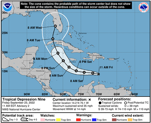
| JMII |
| (Weather Master) |
| Wed Sep 28 2022 03:18 PM |
|
|
|
|
Landfall 3:05 PM Cayo Costa winds 150 mph pressure 940 mb
Based on videos and other data there is some really bad surge south of center - the water level in Naples is 7 feet above high tide and that is open beach not a cove or bay where water can truly pile up.
| vineyardsaker |
| (Weather Guru) |
| Wed Sep 28 2022 04:39 PM |
| Attachment |
|
|
|
|
Question for the experts in our group:
Please look at the area with much less moisture I outlined in black in this pic: https://postimg.cc/hJ9b8Nd8
Could that be dry air weakening Ian and does that means that the flood risks are diminishing for Volusia County?
Thank you!
| IsoFlame |
| (Weather Analyst) |
| Wed Sep 28 2022 04:51 PM |
|
|
|
|
Quote:
Landfall 3:05 PM Cayo Costa winds 150 mph pressure 940 mb
Based on videos and other data there is some really bad surge south of center - the water level in Naples is 7 feet above high tide and that is open beach not a cove or bay where water can truly pile up.
Port Charlotte and Punta Gorda on north side of Charlotte Bay is a fairly populated area with a network of many finger canals off the bay. Given Ian's slow plod across Cayo Costa, with eye tracking up the bay, surge will probably arrive shortly.
We have friends that live on one of these relatively wind-sheltered canals. Charlie landfall put water over their dock/sea wall but didn't get in the house. Ian's slow motion is a more flooding/wetter Charlie. High tide this afternoon around 4 pm will coincide with the arrival of Ian;s west side and pile water up in the residential canals worse than Charlie.
| JMII |
| (Weather Master) |
| Wed Sep 28 2022 04:55 PM |
|
|
|
|
Quote:
Could that be dry air weakening Ian and does that means that the flood risks are diminishing for Volusia County?
Sure looks like it. During its entire run to shore today the SE quad has been dry.
However due to rotation Volusia has a strong onshore flow so for the next 12-18 hours there is still a flooding risk there. Once Ian gets far enough inland the wind will switch to an offshore flow and by then it should be out of juice.
| IsoFlame |
| (Weather Analyst) |
| Wed Sep 28 2022 05:06 PM |
|
|
|
|
Quote:Quote:
Could that be dry air weakening Ian and does that means that the flood risks are diminishing for Volusia County?
Sure looks like it. During its entire run to shore today the SE quad has been dry.
However due to rotation Volusia has a strong onshore flow so for the next 12-18 hours there is still a flooding risk there. Once Ian gets far enough inland the wind will switch to an offshore flow and by then it should be out of juice.
Only measured 1.25" today (so far) on the coast in DBShores. I'll be surprised if we top Mathew"s 8" total.
Based on forecast track with center exiting possibly exiting around NSB or maybe a bit south of there, I believe east central Volusia will be on the southern edge of the heaviest rainfall. I expect areas further a few mile inland (Deltona-Bunnel) and north of me (Flagler Beach, Palm Coast and St. Augustine) may get the 10-12"+ that models advertise. .
| JMII |
| (Weather Master) |
| Wed Sep 28 2022 05:06 PM |
|
|
|
|
Ian's back to hugging the E side of guidance again. Good call by NASA to put Artemis in the shed.
| IsoFlame |
| (Weather Analyst) |
| Wed Sep 28 2022 06:05 PM |
|
|
|
|
Quote:
Ian's back to hugging the E side of guidance again. Good call by NASA to put Artemis in the shed.
Hourly weather round up for east central Florida @ 5 pm about half of what we're currently getting up the coast 50 miles to the NNW of KSC:
https://forecast.weather.gov/product.php...&glossary=0
| Kigeliakitten |
| (Registered User) |
| Wed Sep 28 2022 07:00 PM |

|
|
|
The last time I went out and emptied my rain gauge here around the corner from the Central Florid Zoo, we were up to 84 mm for the day.
| Psyber |
| (Storm Tracker) |
| Wed Sep 28 2022 07:22 PM |
|
|
|
|
Quote:
This thing will come ashore in the Captiva/Cape Coral area. It didn’t listen to the models at all the past week.
Sadly, some models had it as high as 975mb which, given the construction of the storm, was just wrong. I figured 930, which was a bit low but not that low. I still don't know why they thought Tampa Bay was going to take so much storm. It's like the models didn't see the curve ball. Perhaps too much hope for the incoming jet stream? It came too late. God, Bradenton must be getting an absolute deluge of water. Like Hurricane Harvey over Texas kind of rain and storm surge.
Removed part so some people are.
As for the models, many of them had Ian getting hit with a huge drying piece of the jetstream while still out to sea because many of them were aiming the storm higher towards Tampa Bay...giving the jetstream time to beat on the storm. So no, other than general direction, A BUNCH of models didn't have Ian sitting half over Bradenton, Florida/half over the ocean, churning storm surge and twenty for hours or more of rain on basically the same spots.
Win. lose or draw, with global warming 100% being a thing, we're in this together.
| kapSt.Cloud |
| (Weather Hobbyist) |
| Wed Sep 28 2022 08:11 PM |
|
|
Hey, this site is for discussing tropical storms! The current storm is Hurricane Ian. And, OH NO it doesn’t need to be said on this site! Leave the politics at the door!
| Kraig |
| (Weather Hobbyist) |
| Wed Sep 28 2022 08:30 PM |
|
|
|
|
Quote:
Hey, this site is for discussing tropical storms! The current storm is Hurricane Ian. And, OH NO it doesn’t need to be said on this site! Leave the politics at the door!
1000% Agree
| KornR |
| (Registered User) |
| Wed Sep 28 2022 08:45 PM |

|
|
|
You are some kind of cocky canuck. Every thing you post is all "I said this" and "I said that".
Go back to the hockey site while we ride out our hurricane.
NO I really don't give a crap about your feelings, about how bad the world is south of you.
| GeorgeN |
| (Weather Watcher) |
| Wed Sep 28 2022 08:58 PM |
|
|
|
|
The UKMET was actually accurate since Sunday, and the Euro was there but it veered North then back. To say the models were wrong and you were right is inaccurate. To be right, you actually have to post a hypothesis and supporting data. Saying you were right after the fact is just boasting.
Some of us are living through this storm, and we come here for guidance and support.
Also Puerto Rico is not a state. They elected not to be. The US cannot force structure on them, just provide funding and hope for the best. If you insist on introducing political opinions, please be respectful and do some research.
| JMII |
| (Weather Master) |
| Wed Sep 28 2022 10:56 PM |
|
|
|
|
This storm is crazy - on radar it’s 1/2 a cane: totally dry to the S yet super wet to the N. The center of pressure and rotational center are massively decoupled due to shear. This has spread out the TS wind field so it covers 80% of the state. The core is going to exit near Palm Bay / Vero while the NHC has the “center†exiting in Daytona. Never seen anything like this.
| Psyber |
| (Storm Tracker) |
| Wed Sep 28 2022 11:40 PM |
|
|
|
|
Quote:
This storm is crazy - on radar it’s 1/2 a cane: totally dry to the S yet super wet to the N. The center of pressure and rotational center are massively decoupled due to shear. This has spread out the TS wind field so it covers 80% of the state. The core is going to exit near Palm Bay / Vero while the NHC has the “center†exiting in Daytona. Never seen anything like this.
With storm surge that's been reported up to 18 feet too. Imagine what that must feel like with nonstop rain.
The storm that never ends. The jet stream hitting it while it was still over the ocean was a terrible thing. When they finish writing the story of this hurricane, it's going to be like nothing we've ever seen before. The water deluge is just like when Harvey did it's disco dance over Texas for days and days to the tune of 14+ inches of rainfall.
| kapSt.Cloud |
| (Weather Hobbyist) |
| Thu Sep 29 2022 12:45 AM |
|
|
“When they finish writing the story of this hurricane, it's going to be like nothing we've ever seen before.â€
No need to embellish. You apparently haven’t been studying hurricanes for very long. This one isn’t going to be the hurricane of hurricanes! In our not too distant past there was Andrew in ‘92 a Cat 5 when it hit South Florida. Camille of ‘69 also a Cat 5 which hit Mississippi. Going farther back to ‘28 the Lake Okeechobee hurricane which moved the waters of the lake to land. Another Cat 5 the Labor Day storm of ‘35. The Galveston, TX hurricane which killed 5,000 to 8,000 people!
Then we have Katrina of 2005 which turned the three coastal counties of Mississippi into matchsticks! What Camille didn’t take Katrina did! Camille was wind. Katrina was storm surge. You can’t fight water. This current storm Ian doesn’t compare to the storm surge of Katrina. You wrote it was reported Ian caused a storm surge of 18 feet. We’ll wait for the facts. While waiting for the facts know this…the slab lot I purchased in Mississippi (the only things left in all 3 counties) had a storm surge of 32 feet!!
“…it’s going to be like nothing we've ever seen before.†Nothing but hyperbole! Know your facts please before you post!
| Psyber |
| (Storm Tracker) |
| Thu Sep 29 2022 01:20 AM |
|
|
|
|
Quote:
“When they finish writing the story of this hurricane, it's going to be like nothing we've ever seen before.â€
No need to embellish. You apparently haven’t been studying hurricanes for very long. This one isn’t going to be the hurricane of hurricanes! In our not too distant past there was Andrew in ‘92 a Cat 5 when it hit South Florida. Camille of ‘69 also a Cat 5 which hit Mississippi. Going farther back to ‘28 the Lake Okeechobee hurricane which moved the waters of the lake to land. Another Cat 5 the Labor Day storm of ‘35. The Galveston, TX hurricane which killed 5,000 to 8,000 people!
Then we have Katrina of 2005 which turned the three coastal counties of Mississippi into matchsticks! What Camille didn’t take Katrina did! Camille was wind. Katrina was storm surge. You can’t fight water. This current storm Ian doesn’t compare to the storm surge of Katrina. You wrote it was reported Ian caused a storm surge of 18 feet. We’ll wait for the facts. While waiting for the facts know this…the slab lot I purchased in Mississippi (the only things left in all 3 counties) had a storm surge of 32 feet!!
“…it’s going to be like nothing we've ever seen before.†Nothing but hyperbole! Know your facts please before you post!
Look, I understand that you're very emotional and having a difficult time however, being rude and trying to cause problems doesn't help anyone. This is a forecast lounge for people to discuss storms. This isn't a met blog and you are not a met. So please, I encourage you not to say anything if you cannot say anything nice.
| Rhino7170 |
| (Registered User) |
| Thu Sep 29 2022 03:16 AM |
|
|
You are an incredible a....... I wanted ti say this thoughout this whole thing. Please produce your claim of 80% correctness, highly doubt that. Are you a meteriologist? Do you have traing? Or maybe you are wanna be, which is my guess, you live in Canada, you have no idea of what we have here.
| Rhino7170 |
| (Registered User) |
| Thu Sep 29 2022 03:19 AM |
|
|
Quote:
The UKMET was actually accurate since Sunday, and the Euro was there but it veered North then back. To say the models were wrong and you were right is inaccurate. To be right, you actually have to post a hypothesis and supporting data. Saying you were right after the fact is just boasting.
Some of us are living through this storm, and we come here for guidance and support.
Also Puerto Rico is not a state. They elected not to be. The US cannot force structure on them, just provide funding and hope for the best. If you insist on introducing political opinions, please be respectful and do some research.
His posts were so back and forth that he couldn't be wrong in his mind. He contradicted himself numerous time. No need for that attitude on this site that is a serious site on protecting people.
| Rhino7170 |
| (Registered User) |
| Thu Sep 29 2022 03:22 AM |
|
|
Quote:Quote:
“When they finish writing the story of this hurricane, it's going to be like nothing we've ever seen before.â€
No need to embellish. You apparently haven’t been studying hurricanes for very long. This one isn’t going to be the hurricane of hurricanes! In our not too distant past there was Andrew in ‘92 a Cat 5 when it hit South Florida. Camille of ‘69 also a Cat 5 which hit Mississippi. Going farther back to ‘28 the Lake Okeechobee hurricane which moved the waters of the lake to land. Another Cat 5 the Labor Day storm of ‘35. The Galveston, TX hurricane which killed 5,000 to 8,000 people!
Then we have Katrina of 2005 which turned the three coastal counties of Mississippi into matchsticks! What Camille didn’t take Katrina did! Camille was wind. Katrina was storm surge. You can’t fight water. This current storm Ian doesn’t compare to the storm surge of Katrina. You wrote it was reported Ian caused a storm surge of 18 feet. We’ll wait for the facts. While waiting for the facts know this…the slab lot I purchased in Mississippi (the only things left in all 3 counties) had a storm surge of 32 feet!!
“…it’s going to be like nothing we've ever seen before.†Nothing but hyperbole! Know your facts please before you post!
Look, I understand that you're very emotional and having a difficult time however, being rude and trying to cause problems doesn't help anyone. This is a forecast lounge for people to discuss storms. This isn't a met blog and you are not a met. So please, I encourage you not to say anything if you cannot say anything nice.
You've been an ahole this entire time..... Shut your mouth with what you think you know or show actual quulifications and your so called 80% bs you think you have, even tough you contradicted yourself numerous times on this very thread.
| JMII |
| (Weather Master) |
| Thu Sep 29 2022 11:20 AM |
|
|
|
|
Quote:
The water deluge is just like when Harvey did it's disco dance over Texas for days and days to the tune of 14+ inches of rainfall.
Ummm NO: https://waterdata.usgs.gov/fl/nwis/current/?type=precip&group_key=county_cd
Isolated locations got 12-14" of rain. The water you're seeing on the news is surge related. As Ian leaves the area the water levels are falling but still higher then normal, for example Ft Myers is still 3' above but that is way better then the 7' over-your-head situation yesterday. Unlike other inland floods these areas will drain back into the sea with the next 12 hours.
This was a large surge event from Pine Island Sound south to Naples and an extreme wind event localized to the Boca Grande, Pine Island, Sanibel, Cape Coral, Ft Myers, Punta Gorda area. Now this is a very densely populated part of SW FL where about 1.2 million people live so the cost in property damage will be significant.
| kapSt.Cloud |
| (Weather Hobbyist) |
| Thu Sep 29 2022 11:38 AM |
|
|
I wasn’t being rude. I was holding your feet to the fire with facts. You’re not as knowledgeable as you think you are. Yes, this site is for discussing and acquiring information about current storms. You went beyond that when you wrote what scoundrels we are in the U.S. for not caring about 3rd world countries. BTW, Puerto Rico is NOT a 3rd world country.
Finally, this site is the first place I come to when a possible hurricane is brewing. We don’t need to read your hyperbole with your know-it-all attitude. Truth be told you’re wrong 80% of the time.
| TanukiMario |
| (Registered User) |
| Thu Sep 29 2022 01:12 PM |
|
|
I've been lurking on this forum for years and I find it somewhat weird that this thread is the one to make me sign up.
First a little about me. I'm from Puerto Rico and divide my time between there and Miami. Have properties in both places, hence my interest in following these storms closely.
I was on the ground during Maria and had my street flooded with over two feet of water. Luckily I was aware of the possibility of flooding and built my house 24" above street level, so got away with just a few inches of water inside.
In PR have also been through Hugo, Georges, Hortense and in Miami I was here for Irma, but I missed Andrew.
The focus at this point should be on helping those folks in Ft. Myers and the surrounding area. From experience, the devastation of a direct hit is overwhelming and it is difficult to get in the clean up and rebuilding stage when the job seems so big.
Which leads me to the main reason I decided to post:
Y'all are wrong about PR. Sure there is mismanagement and some governmental fraud, but in the case of Maria I doubt it was (at least initially) intentional. When government bureaucrats are tasked with a difficult task that they are not really equipped to handle they tend to make all sorts of rookie mistakes - like hiring companies that make big promises but aren't up to the job.
The destruction of the power grid after Maria was such that the correct fix would have been to raze and rebuild as opposed to just fix. Since that would have kept the populace without power even longer - I think they just chose to put band-aids on an aging, beat-up infrastructure. I now have two power poles in front of my house, an old broken pre-Maria one and a new replacement. Ideally the old beat up one would have been removed, but the phone and internet lines are still attached to that one. Its just bad management or incompetence, not necessarily corruption.
Not doing things right the first tie means that now you have nice, shiny new power poles interspersed with old rotting wood ones and when Fiona showed up, whatever survived Maria got beat up.
I imagine in Fort Myers they will replace *entire* electrical grids, not just bits and pieces. Why? Because there is more access to parts, more access to crews and more money. If they do a piece-meal repair, then the next storm will just take down whatever was damaged by Ian but still workable...
PR is not a third world country but it is trying hard to become a second world one (I say that only partly in jest). There is corruption, but I attribute only 10% of the post Maria mismanagement to that particular problem; there were many others: Initially a very slow response from the Federal Government, the difficulty of bringing parts and labor in due to airports and ship terminals being down and of course, being an island in the middle of the ocean. Add to those difficulties a lot of posturing from politicians using the disaster to gain political capital (R vs D as well as PNP vs PPD and every permutation of those four parties working against each other) and it was just a total cluster*.
Prepare for the political crap-fest of the two parties blaming each other if/when problems start to arise in the Ft Myers recovery.
As for PR not choosing to become a state, I could write a whole book about that one that would include the story about how the PR PPD party did everything it could while it held power in the beginning of the modern PR constitution era to disincentivize Puertorricans from wanting statehood to how the Republican Party is currently doing whatever it can to avoid a majority Democratic state from joining the union. Let's just say propaganda works.
So - yeah, I find the whole "PR is a third world, corrupt country that doesn't have the common sense to become a state and we (Americans) just send them money out of the goodness of our hearts" thing a little insulting, but I'll chalk it up to lack of information and propaganda.
Anyway - hope this is my first and last post, because as much as I thought Ian was headed to Ft Myers since Monday, I'm not a meteorologist and have absolutely no valid reason to have thought that other that the visual of that long NE to SW trail of clouds across the FL peninsula with super clear air over Tampa through the weekend. That line of clouds pretty much pointed like an arrow in the direction Ian headed - but I don't know the technical reason why, so can't really contribute in any meaningful way.
| cieldumort |
| (Moderator) |
| Thu Sep 29 2022 01:31 PM |
|
|
|
|
Please keep discussions strictly on Ian and modeling about Ian. Thoughts about climate change or politics belong in a different forum Perhaps even a different website? If mods have to babysit posters we will ban. Use the ignore features available and don't feed trolls. Do not reply to this warning. Just comply. Thanks.
| Psyber |
| (Storm Tracker) |
| Thu Sep 29 2022 04:12 PM |
|
|
|
|
Quote:
As the Euro and GFS track South, I'm still trying to figure out how the UKMET calculated this track all the way back to Sunday. While the other plots were skipping around, UKMET was glued to this area. I know the GFS is better for open ocean runs as it doesn't account for land interaction as well. The Euro did forecast the same landfall as UKMET on Sunday, then it started to track North until it snapped back. I need to do some more research on the UKMET model.
Tampa and the West coast still need to prepare. Irma ran up the state then jogged back towards Tampa in 2017. The eye was 10 miles from my house and it shredded a lot of trees.
I didn't understand the usually pretty dang good UKMET this entire storm. You are exactly right, and really what I was trying to make the point that I've been trying to make about some models. UKMET had the storm going up to 992mb and north of Tampa for a period of time that was quite honestly a bit dangerous. I'm not a meteorologist however it looks to me like it relied on the jet stream making it sound quicker than it did. From there, Ian did basically the same thing which was meander in the same spot for a very long time. The UKMET had it out to sea though, not half on, half off. CHC had a couple of pretty significant East/West bobs too.
| Psyber |
| (Storm Tracker) |
| Thu Sep 29 2022 04:15 PM |
|
|
|
|
Quote:
I've been lurking on this forum for years and I find it somewhat weird that this thread is the one to make me sign up.
First a little about me. I'm from Puerto Rico and divide my time between there and Miami. Have properties in both places, hence my interest in following these storms closely.
I was on the ground during Maria and had my street flooded with over two feet of water. Luckily I was aware of the possibility of flooding and built my house 24" above street level, so got away with just a few inches of water inside.
.
Welcome! I'd love to discuss some things in your private messages if that is okay?
| GeorgeN |
| (Weather Watcher) |
| Thu Sep 29 2022 07:42 PM |
|
|
|
|
Please keep posting. I’m curious about your cloud trail idea and how it could explain the accuracy of the UKMET with this storm. A good plot not only gives people more time to prepare but saves a lot of anxiety for people not in the actual landfall location. In this case, a lot of people in Tampa panicked for no reason.
In my case it was good to prepare as my window panels took a beating and power is still out. Even though I’m north of Tampa, I still recorded 60 mph gusts.
| JMII |
| (Weather Master) |
| Fri Sep 30 2022 12:14 PM |
|
|
|
|
Quote:
In this case, a lot of people in Tampa panicked for no reason.
Well if the Tampa track would have verified then that panic was warranted. However as soon as Ian came off the coast of Cuban it rode the E side of the cone. A each hour went by the direct threat to Tampa kept dropping while places further south became more under the gun. As with Charley the shape of the west coast and angle of approach meant a wide area of landfall was possible, yet the worst wind effects would be concentrated in only a small area so pin pointing landfall became critical. The surge however was massive, as far SE as Flamingo & Everglades City got swamped too. Almost nobody lives down there so you will not see news reports about it. However I fish these area and have seen pictures from local guides showing water filled streets with around 2-3 feet of surge but clearly not the 5-7 Ft Myers saw.
The problem was the NHC wasn't shifting the cone S despite the storms track on radar. The models apparently misjudged / didn't see how strong the western jet was. Remember at one point Ian was forecast into the Big Bend area and slowing down in GA which in hindsight seems almost impossible given its final track across FL and back into ocean.
Running thru the models here: https://flhurricane.com/clarkmodelanimator.php?year=2022&storm=9 Loop #24 shows the UK model with the right path but the spread was large and the NHC went with the average which put Tampa in the middle. GeorgeN noted this solution in his post #114262 - Mon Sep 26 2022 09:54 AM Loop #25 seems to confirm this was the right call, it took until Loop #27 for all the other models to get onboard but even those tracks were ultimately a bit too far north after landfall.
Watching this frame-by-frame https://www.nhc.noaa.gov/archive/2022/IAN_graphics.php you can see several plots of NE movement off Cuba, followed by a N wobble, then a clear NE path across the state. If the N wobble had been maintained landfalll might have been more like Sarasota. You get even more details with this graphic: https://www.nhc.noaa.gov/refresh/graphics_at4+shtml/152538.shtml?gm_track#contents Advisory #25 was almost spot on for landfall but the angle was wrong and this was never correct as the NHC continued with this N motion when it was actually more NNE and finally NE.
Given the devastation of Ian this whole scenario will be studied in even more detail for years. The NHC publishes a report in the off season with preliminary findings too. The final report for Wilma is 27 pages including wind and plot accuracy tables, plus a radar image showing NW Broward where I live in the eyewall.
| TanukiMario |
| (Registered User) |
| Fri Sep 30 2022 02:46 PM |
| Attachment |
|
|
Here, check this out - what I was referring to indicated with the black arrow.
https://flhurricane.com/cyclone/download.php?Number=114400
Even more impressive is the satellite imagery (which I couldn't find) because that cloud formation kept up in the same direction all the way across FL and out to the Atlantic. My thinking was that whatever that "front" (quotes because I don't know what that is or is called, but it looks like a winter cold front to me) was, Ian was going to skirt along its edge. What I dodn't get is why the models at that time still had the storm moving across Tampa and up the north. <shrug>
Again - I don't know anything about this stuff - just an observation.
PS - image is from a radar loop by Brian McNoldy, Univ. of Miami, Rosenstiel School at https://bmcnoldy.rsmas.miami.edu/tropics/radar/
| JMII |
| (Weather Master) |
| Fri Sep 30 2022 04:18 PM |
|
|
|
|
Quote:
My thinking was that whatever that "front" (quotes because I don't know what that is or is called, but it looks like a winter cold front to me) was, Ian was going to skirt along its edge. What I dodn't get is why the models at that time still had the storm moving across Tampa and up the north.
Excellent observation... and it was a front: https://www.wpc.ncep.noaa.gov/archives/noaa/2022/noaad1_2022092712.gif
5:10 into this video https://www.youtube.com/watch?v=psxR5JRjCPA Levi shows it too. And at the 6:00 mark you can see the moisture cut off (dry air behind NW / wet ahead SE) marking the front clearly. Problem is the models predicted this feature would be 100-150 miles further N as shown in the video. That distance gap is pretty much the miles between Ft Myers and Tampa.
A very similar setup is what pushed Wilma very quickly NE across the state, coming ashore at Cape Romano and exiting near Jupiter. It went from a Cat 2 storm outside to a cold (by FL standards) day within a matter of hours. The high was 87, then the low was 65. I was doing clean up wearing a hoodie and jeans and so that dramatic change in weather is stuck in my head forever. One day hot, summer tropical storm... boom next day blue bird sunshine, crisp and cool out.
Thanks for the radar loops.
| Psyber |
| (Storm Tracker) |
| Sat Oct 01 2022 04:48 PM |
|
|
|
|
Not a weather post but SIXTY FIVE people confirmed dead so far.
GOOD GOD. One of the deadliest storms ever!
If you're in one of the areas hit, I wish you a speedy recovery both health and financially.
Wow. Just wow. More people should have evacuated. I guess while it was half in the gulf and half over land, it must have been a living nightmare.
| kapSt.Cloud |
| (Weather Hobbyist) |
| Sat Oct 01 2022 11:19 PM |
|
|
You do like to embellish don’t you?
WOW! Just wow! GOOD GOD! These ARE the deadliest storms ever in Florida.
https://www.miamiherald.com/news/weather/hurricane/article266626756.html
Would you please wait until the final count is done before going off the deep end?
WOW! Just wow! GOOD GOD! 10,000 to 12,000 died from the Galveston, Texas hurricane in 1900! Now go take your anti-anxiety meds before having a stroke!
| Keith B |
| (Weather Hobbyist) |
| Tue Oct 04 2022 06:26 PM |
|
|
Delayed post. Good call on the cat 4. GOM waters were very warm to hot and deep.