| cieldumort |
| (Moderator) |
| Tue May 31 2022 05:20 AM |

|
|
|
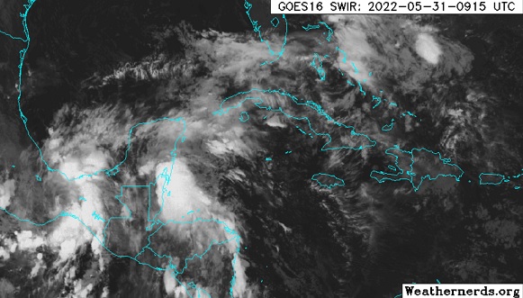
A broad and complex region of low pressure and disturbed weather presently over Yucatan/Belize to Chiapas/Oaxaca is associated with winding down former Hurricane Agatha coming northeast out of the far eastern Pacific interacting with diffuse remnants of a Central American Gyre and an approaching surface trof.
While this somewhat soupy concoction may start out a mess, odds favor organization throughout the new week, and at least one Tropical Cyclone is expected to emerge within a few days (presently 60% NHC odds as of this entry) in the western Atlantic. There is also a long shot Agatha retains her name, but this is less likely given the rugged mountains of Mexico and the significant interaction with the other players outlined above.
This region has not yet been Invest tagged, but will likely be designated 91L, barring the less probable outcome of Agatha holding together. Given the likelihood of development within 72 hours, we are starting a lounge on this well-advertised system now.
Models generally want to ramp the forecast tropical cyclone up, and run it near or across Florida and then up the Gulf Stream and/or out to sea.
The following are some 0531 0z Run summaries:
GFS - Two and possibly three systems. At least one short-lived TD or weak TS in the Bay of Campeche until dissipation Friday. New system (TD or TS) emerges between northern Cuba and the Keys Friday night, crossing the Bahamas as a TD or TS Sat/Sun and heads out to sea.
ECMWF - Strengthening Tropical Storm crossing S. Florida over the coming weekend. Cat 1/2 hurricane passing east of the OBX Monday.
HWRF - Appears to retain enough of Agatha as to reform a center in the extreme southwestern Gulf of Mexico, and keeps it in this region until landfall this coming Friday along the coast in the southern Bay of Campeche.
HMON - Begins exiting the Bay of Campeche, on a northeasterly heading, by this coming weekend as a Tropical Storm
Title Updates:
The broad low pressure we have been tracking that is partially made up from remnants of east Pac Agatha has now been Invest tagged, 91L, and the title of this Lounge has been updated accordingly. 6/1/22
Advisories are being issued on Invest 91L by 5PM today, June 2. While not yet a TC, the Hurricane Center has opted to use the Potential Tropical Cyclone designation, as tropical storm conditions on land are expected within 48 hours. The title has been updated accordingly. 6/2/22
PTC 1 finally organized into a bona fide tropical cyclone predawn Sunday June 5, east of Florida, and is, at long last, Alex. 6/5/22