| cieldumort |
| (Moderator) |
| Tue Sep 05 2023 09:02 PM |

|
|
|
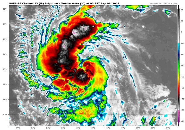
Ultimately, those of us on land are more concerned about track than intensity, assuming Lee's intensity is going to be a problem no matter what (at this point it's fair to assign close to 100% odds of Lee becoming a hurricane within 5 days, for example).
But Rapid Intensification sooner rather than later, and just the timing of Lee's rounds of R.I. in general, could influence Lee's destinations, and Lee appears to be preparing to enter a phase of quick if not technically rapid intensification as soon as overnight tonight. This is not to say that Lee goes from 40 KTS to 70 KTS by morning, but that this is plausible, and not presently captured by the models nor in the official NHC forecast.
As members and lurkers of this site know, typically the stronger the T.C., the greater the propensity for it to feel the tugs poleward. But a turn north is not always the outcome, as influences from a much stronger-than-forecast Lee could ultimately help buff up the ridge to his north. These types of things are still challenging for models and forecasters to predict. In fact, in the case of Lee, intensity five days out may be about as easy to forecast as location (Usually intensity being far more challenging).
What seems all but certain and is predicted by most reliable models is that Lee becomes a Major hurricane within 5 days as he tracks roughly WNW. Possibly a little left or right of that, but unlikely to be much outside of the NHC 5 Day Cone of Uncertainty, if at all.
Warm-water prawn of the sea, Lee