| cieldumort |
| (Moderator) |
| Wed Sep 20 2023 02:23 AM |

|
|
|
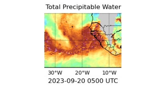
Above Total Precipitable Water (MIMIC-TPW2) of this wave, taken at 09/20/23/05z
"MIMIC-TPW2 is an experimental global product of total precipitable water (TPW), using morphological compositing of the MIRS retrieval from several available operational microwave-frequency sensors." ~ About the MIMIC-TPW2 product
The wave now just coming off the coast of west Africa continues to have model support for a southerly track, at least initially, with the GFS increasingly most emphatic. However, now is probably a good time to mention that global model track runs beyond 7-10 days are often wildly unreliable, and the GFS may also be displaying some southerly bias of late.
Caveats provided, here are some 0z runs from 9/20 as they come in up to 7 days out
Models at 7 days out from 09/20/0z
GFS: 974mb Hurricane just about 75 miles or so east of the Windward Islands, roughly along the same latitude as the southernmost Commonwealth of Dominica at 0z Wednesday Sep 27.
GEM: Nearly in the same location as the GFS at this exact time, but only as a 1008mb open wave.
ICON: Lagging behind the GFS and Canadian above, located around 15.5N 55.5W as a 1005mb Wave/TD/low-end TS.