| cieldumort |
| (Moderator) |
| Mon Oct 09 2023 01:09 PM |

|
|
|
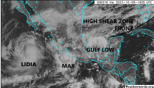
A small area of tropical-ish low pressure has developed in the southwestern Gulf of Mexico and is being drawn slowly northward this morning, presently centered roughly 120 or so miles north of Coatzacoalcos, Mexico.
This Low is not yet Invest tagged, but soon may be. Regardless of an Invest tag or not, the disturbance is set to become part of a complex weather event that combines several other features: East Pac Lidia and East Pac Max that are both heading eastward, a stalling front draped across the southern Gulf, and an abundance of high shear near and possibly soon over whatever this tropical-ish low becomes.
Just what this incipient cyclone becomes at the moment is too early to say, but NHC did go ahead and flag it with an opening bid of a possibly conservative 20% odds for becoming a tropical cyclone within the next 48 hours, before likely merger with those other features.
While not likely to itself make landfall as a tropical storm, it does seem likely to enhance heavy weather impacts along and just inland in the Gulf Coast states from south Texas all the way to Florida, and if it wasn't for this feature having a real chance of being named before being absorbed, I would have elected to move this thread to another forum.