| cieldumort |
| (Moderator) |
| Mon Jul 29 2024 02:05 PM |

|
|
|
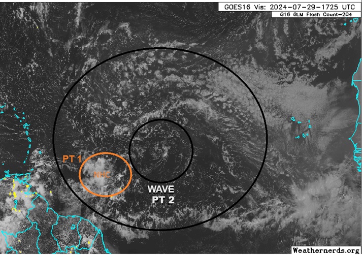
Here is a current view of our two part Area of Interest. NHC has most everyone focused on the area of disturbed weather with some gentle elongated rotation I have labeled PT 1. However, the more significant player is likely to be the tropical wave and its large gyre I have labeled here as PT 2.
Both the gyre and its embedded well-defined LLC are presently void of any thunderstorms, as is the area of disturbed weather to its southwest (PT 1). With echos of 2013, the Atlantic has been struggling throughout the month of July to produce anything given the exceptionally large plumes of SAL coming off Africa, along with an unfavorable MJO state. As we enter August this begins to turn less unfavorable, with a reduction in the amount of dry, dusty Saharan air forecast to coincide with at least a somewhat more favorable MJO background state.
Big picture, gradual organization of the two combined features, probably ultimately focusing more within the gyre (PT 2), does seem possible.
Operational model runs have really backed off today, and 50% development odds within 7 days may be about right.
The risk of either feature or their combo becoming a strong tropical storm or hurricane is of course better if the system/s overall stay/s south or north of the largest and tallest islands. Significant development north of those islands could favor a track more towards the Carolinas, and/or even out to sea. Significant development south of those islands might favor central America to Mexico. Modest development might favor Florida and/or Gulf Coast states.