| cieldumort |
| (Moderator) |
| Mon Oct 14 2024 06:14 PM |

|
|
|
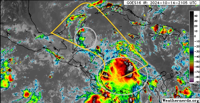
Above: A pair of convectively active to at times very convectively active vorticity lobes in the western Caribbean circled in gray, and the rough outline of greatest potential for a broad area of low pressure to form this week outlined in deep yellow.
A broad area of low pressure has been advertised by many models to form in the western or northwestern Caribbean sometime this week, and a tropical cyclone could form in conditions that are already favorable for genesis. Of the two vorticity lobes in the image above, the one more likely to have sufficient time to cook over water is the southern features, but both have a shot. Alternatively, a new lobe could also emerge that would stand the best chance.
This region is not yet Invest tagged, but should a more cohesive disturbance evolve as many model runs foresee, NHC would likely assign one at that time and the title would be updated accordingly.
At the moment, this looks like a possible central America to Yucatan threat more than anywhere else, with blocking high pressure shutting down any immediate entryway to the US.
This is now Invest 95L on 10-17 and the title has been updated accordingly
2024-10-17 18:00 15.9 -82.0 20
Invest 95L is now Invest Potential Tropical Cyclone FIFTEEN and the title has been updated
2024-10-18 18:00 17.5 -84.6 30
Nadine
100 AM CDT Sat Oct 19 2024
17.3N 86.4W
1004 MB
Ciel
More details to come