| cieldumort |
| (Moderator) |
| Tue Nov 12 2024 12:39 AM |

|
|
|

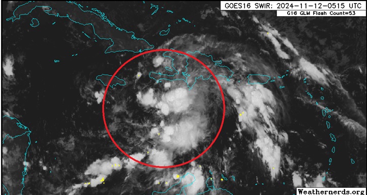
Above: Invest TBD in the north-central Caribbean tracking west to merge with a broader region of low pressure and favorable environment for further, quite possibly rapid development, later this week into next.
No vort-centric models are available yet. Here are some summaries of the 12/0z Globals that have locked on to this developing cyclone:
ICON
Apparent TD by Thursday in W Carib. Storm by Friday. HUR by Sunday. Major by Monday while tracking nw towards Yucatán. Scrapes/rounds Yucatán Monday as a Major. Enters south-central GOM by Tuesday (end of run)
GFS
Apparent TD by Wednesday evening sw of Jamaica. Storm Thursday just east of Nicaragua/Honduras. HUR Friday closer to Nic/Hon border tip. Major by Sat while still east Nic/Hon... meanders.. Cat 4 in this area by Sunday night. Tracks NW-NNW and enters Gulf between Yucatán and Cuba on Tuesday still Cat 3/4. Landfall around Naples-Fort Myers as Cat 3 Wed Nov 20th. Exits Fl on 21st, hooks ESE and rakes Bahamas Thurs and Fri Cat 2/1/Storm on weakening trend.
ECMWF
Apparent TD by Thursday ne of Nicaragua/Honduras border. Storm Friday N of Honduras. HUR by Sun while east of Nicaragua/Honduras border. Meanders, then beings tracking northwest and Majors Monday. Approaches the Yucatán Channel Tuesday night as a Cat 4/5. Landfall on western Cuba Wednesday night as a Major in the 3-4 range, perhaps. Tracks across western Cuba through end of run. Devastating solution for Cuba, if verified.
More details to come. This feature has the potential to become a very rare late-season landfalling Major hurricane.