| cieldumort |
| (Moderator) |
| Sun Jul 13 2025 10:16 AM |

|
|
|
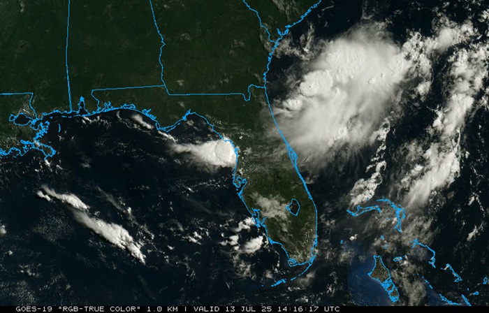
Above img cr: College of DuPage NEXLAB
We are now tracking an incipient trof of low pressure off the southeast coast, forecast by many models to develop into a closed low. Given its proximity to land and the overnight blowup of deep convection to the east and northeast of Florida, we are already starting a Forecast Lounge on this feature, despite the lack of an official Invest tag. The next tag on the list should be 93L.
While model support from most global operational runs has not been especially impressive, their individual ensemble members and several of the hyper-focused runs of convection allowing models (CAMS) advertise the potential for development into a TD even before crossing Florida from the east, ultimately to land into the northeastern Gulf, where conditions for more significant development could exist.
Tracking forecasts suggest that this area of low pressure could come ashore somewhere from as far east as between the far western Florida panhandle to as far west as the upper Texas coast, with more probable locations roughly in the middle of these points, but it is still very early and a bona fide low has yet to even form. Much more fine-tuning to come.
The title will be changed if/once an Invest tag is added to this feature. Current NHC odds of development are near 0% within 48 hours and 20% within 7 days, but this seems likely to go up, perhaps substantially, by tonight.
The trof we have been following off the southeast coast has now been Invest tagged, 93L, and the title has been updated accordingly.
Ciel