| cieldumort |
| (Moderator) |
| Sat Aug 16 2025 10:50 AM |

|
|
|
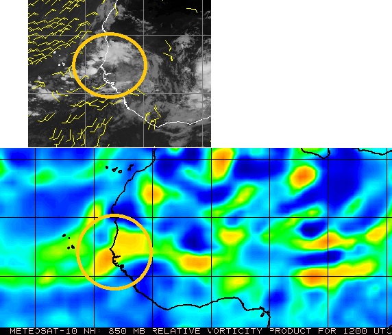
A stout wave about to roll off westernmost Africa and into the far eastern Atlantic has had some fairly consistent model support for genesis and a track that takes it far westward, and we are now starting a Lounge on this feature at this time*
Some of the very big players in the ability of a Tropical Wave to develop and continue west are all in a favorable state right now. The Madden-Julian Oscillation (MJO), Convectively Coupled Kelvin Wave (CCKWs) and more are all in nearly ideal positions to support more TC genesis and intensification across the basin at this time, to say nothing of very warm SSTs out in the western Atlantic (See Erin). Higher pressure to the north of the waves tracking westward from Africa has been setting in, keeping them on that westward trajectory.
*The wave now exiting western Africa may or may not meld with a lead wave that is currently floundering. Some runs combine these two into one, others primarily keep the exiting wave dominant and isolated from the lead wave.
Earlier today, Aug 21, the northern portion of the broad trof/wave we have been tracking since its exit from Africa has been Invest-tagged, 90L, and the title has been updated accordingly. The robust southern lobe is now starting to track through northern South America and could reemerge in the southwestern Caribbean. Should that portion show signs of development a new Lounge may be opened up just for it
2025-08-21 12:00 90L 17.1N 55.5W 25 KTS
2025-08-23 18:00 Fernand 26.6N 61.7W 35 KTS
Ciel