| cieldumort |
| (Moderator) |
| Wed Aug 16 2023 02:33 PM |

|
|
|
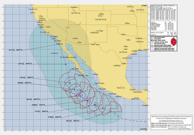
Above: Initial official forecast and forecast track for Hilary as of 08/16/23/1200z.
Hatched region denotes 34KT wind danger area/USN ship avoidance area.
Forecast from NOAA and graphic has been reformatted. NRL.
Tropical Storm Hilary has formed in the very active, El Niño-fueled eastern Pacific, and is officially forecast to head towards southern California. Water temps along the coasts of Baja and California are considerably warmer than average, and conditions overall for development will likely make Hilary a Major by Saturday. In fact, Hilary could even enter the southwestern United States still a bona fide tropical cyclone.
Whether or not Hilary maintains itself as a tropical cyclone into the US, her remnants could easily deluge normally very dry parts of the country that will not absorb the unusually copious rains, with flash flooding likely. In fact, the main threat from Hilary in the US could continue with very high levels of moisture rounding the Heat Dome, pushing ENE to NE.
On its initial official forecast, winds will likely be howling at higher elevations and into canyons within portions of the southwestern U.S., possibly gusting to hurricane-force.
Disclaimer to all the above, forecast errors can be large.
The title has been edited to reflect the most recent official NHC forecast that explicitly shows Hilary still intact as a 60 MPH tropical cyclone over Los Angeles, CA. - Ciel