MikeC
|
| (Admin) |
| Mon Jun 12 2006 10:39 AM |
|
|
2:30PM EDT Update
Find Misc Alberto Information (closings, evacutions, EOC phone numbers, etc.) here
Let us know what the conditions are like in your area here
Added long term animation link and storm surge projeciton map links the lower area of the post.
flhurricane long term radar recording of Alberto
Alberto Related Storm Surge Projections for:
Cedar Key Area
Tampa Bay Area
Appalachicola Area
Apologies for bandwith issues as they happen, we are working to help them, and could use donations to help us move along in that regard to a new coloc facility.
11:50AM EDT
Jason Kelley has updated his blog below for more storm information.
10:35 AM Update - Hurricane Warnings Issued
Hurricane Warnings have been issued for the Florida Gulf coast from Longboat Key (North of Sarasota) northward to the Ochlockonee River (South of Tallahassee) -- This includes the Tampa Bay/St. Pete area., Alberto is not a Hurricane yet, but may be upgraded later. Winds are now at 70MPH, just under Hurricane force.
The official forecast is now calling for a Category 1 hurricane making landfall, with winds of 75MPH at landfall. Alberto has won the war with the shearing.
The air force hurricane hunter plane found the center remofred northeast of where it was before, near the strongest convection, which means it may have some room for more strengthening, thus the hurricane warnings. Pressure has dropped to 997 mb.
Likely the reason the Hurricane Warning extends so far south is because most of the convection remains to the East of the Center.
Storm Surge will be more of an issue as well -- 8 to 10 feet in some areas east of where the system makes landfall. People in the coastal areas need to prepare now, and be prepared for this system. The Gulf coast in the warning area is a shallow shelf, and is very conductive to intensifying the effects of storm surge. If you are immediately along the coast east of the landfall point and in the warning area, I'd suggest leaving.
10:30 AM Update
Unconfirmed reports that Hurricane Warnings will be issued near the big bend area of Florida. From EOC conference....
More to come soon...
Original Update
Tropical Storm Warnings exist from Englewood (south end Between Sarasota and Cape Corlal) norward to Indian pass (Near Port St. Joe east of Panama City Beach). Alberto has organized a bit overnight, and may strengthen a bit more (and since overnight it has gotten more organized, may be a strengthening system as it makes landfall) before making landfall as a Tropical Storm since shear is starting to fade away (note shear still exists), and the fact that its in the Gulf now.
The center is still mostly exposed, so it may keep it from strengthening too rapidly,. the dramatic satellite photo below doesn't tell the whole story. The convection is still mostly to the east of the Storm, even with this blow up this morning. Alberto may have won the overnight round, but it still has another round to go along with the dry air on the northwestern side of the system.

There is also still quite a bit of model divergence in this state of the game, anywhere in the Warning area needs to watch what this system does.
Alberto has woken up this morning, and convection is starting get around the center more, with most of the activity still filling out to the east up through the Florida peninsula, which is covered in Alberto's cloud shield now. Landfall is still expected for the big bend area. West Central Florida will see the most rain most of the day, before Alberto makes landfall.
Because of the coastline at the Gulf, there could still be quite a bit of storm surge even with a Tropical storm, 4-8 feet above normal toward the east of the landfall point. Winds will be moderate, and the threat for isolated small tornadoes will exist for much of the Warning Area. In fact, some have already been reported near Sarasota and in other parts of Western Central Florida.

More to come during the day...
Event Related Links
flhurricane long term radar recording of Alberto
Alberto Related Storm Surge Projections for:
Cedar Key Area
Tampa Bay Area
Appalachicola Area
Radar Imagery:
Talahassee, FL Long Range Radar Loop
Florida Keys Long Range Radar Loop
Tampa, FL Long Range Radar Loop
Miami, FL Long Range Radar
Melbourne, FL Long Range Radar
Cancun Radar
Western tip of Cuba radar
Model; Plots (More at bottom of main page):
"Spaghetti" style model plots from Colorado State / Jonathan Vigh
Alberto:

Animated Skeetobite Model Plot
Google Map Plot of storm
Animated Model Plot of Alberto
Model Plot of Alberto (Graphic from the South Florida Water Management District)
Visible Satellite Floater
IR
Animated Floater with overlays
More Satellite Images of system
| Storm Hunter |
| (Veteran Storm Chaser) |
| Mon Jun 12 2006 10:48 AM |

|
|
|
noticed that at buoy 42003 now has sea 19 ft and winds from south.... also noticed when the center moved to the nw west of it... the air temp increased alot since last night at 10... sucking up some warm moist air from carribean... dewpt went up to!
http://www.ndbc.noaa.gov/station_page.php?station=42003
| Ron Basso |
| (Storm Tracker) |
| Mon Jun 12 2006 10:52 AM |

|
|
|
Boy, I go to bed expecting a TD this morning and wow - the convection has exploded and Alberto has grown stronger with the NHC now forecasting a strong tropical storm. Looking at the IR, it looks like the LLC has tucked itself under the SW side of convection and is no longer exposed. If so, there could be a steady strengthening trend unless shear really starts to take over. Not good news for us coastal residents on the Nature Coast. Might have to move some things off the ground floor for coastal flooding tomorrow. Yikes!

http://www.ssd.noaa.gov/goes/east/gmex/loop-avn.html
| Storm Hunter |
| (Veteran Storm Chaser) |
| Mon Jun 12 2006 11:01 AM |
|
|
|
|
looks like to me the center is becoming exposed again..... i think he also has jogged a little bit to the north.... but i think in a few mins when the vis comes up... we should see the edge or the center of alberto
| Hugh |
| (Senior Storm Chaser) |
| Mon Jun 12 2006 11:05 AM |
|
|
Storm Hunter: I think you're reading my mind!
The first visible image to completely show Alberto won't be available for an hour I don't think, and who knows what it will show... shear does appear to be putting up a good fight, even though early this morning Alberto is putting up a bigger fight.
Looking at the overnight visible loop, it looks like the LLC is due south of Pensacola. I think the Big Bend is gonna get alot of rain but the LLC will come onshore closer to Apalachicola.
| vvvteddybearvvv |
| (Weather Watcher) |
| Mon Jun 12 2006 11:06 AM |

|
|
|
this thing go a goood night sleep
happy start of the season to ya hugh

| Random Chaos |
| (Weather Analyst) |
| Mon Jun 12 2006 11:07 AM |

|
|
|
I'm looking at that convection bloom north of the center and not liking it one bit. Good thing it's close to the coast. It looks almost as if it's trying to develop a new center within the convection bloom. Take a look at IR - you can see it doing something in the SW quadrant of the convection bloom. It's got a point that is developing warmer cloud tops surrounded by colder cloud tops, which for a TS isn't expected yet, especially so far from the low pressure center. Waiting for the next recon pass to see if the center has displaced into the convection.
Note: the 85GHz pass was before it started developing this, so I can't check internal structure yet.
20-frame: http://wwwghcc.msfc.nasa.gov/cgi-bin/get...mp;numframes=20
AVN IR anim: http://www.ssd.noaa.gov/goes/flt/t1/loop-avn.html
--RC
P.S. Don't use what I say for fact. I'm just an amature

| vvvteddybearvvv |
| (Weather Watcher) |
| Mon Jun 12 2006 11:11 AM |
|
|
|
|
i am glad the new track has me out of its sight
| Storm Hunter |
| (Veteran Storm Chaser) |
| Mon Jun 12 2006 11:15 AM |
|
|
|
|
recon up and on the way... yeah
URNT11 KNHC 121109
97779 11034 20292 88700 54900 34014 56931 /4587
RMK AF305 0401A ALBERTO OB 01
looks like they just flew off of south pensacola/mobile.. heading southeast on inbound to center
**does anyone know where Af recon is based out of? i was starting to think TAFB, in bay county...... **i plotted worng cord... looks like they are coming out of home base
| Random Chaos |
| (Weather Analyst) |
| Mon Jun 12 2006 11:22 AM |
|
|
|
|
Just a note on the track: models are still showing a large divergence between them, so if you're anywhere on the FL panhandle or the northern half of the west coast of the penninusla, you're still within the potential track cone.
Here are the tracks:
http://www.sfwmd.gov/org/omd/ops/weather/plots/storm_01.gif
http://euler.atmos.colostate.edu/~vigh/guidance/atlantic/early1.png
http://euler.atmos.colostate.edu/~vigh/guidance/atlantic/late1.png
| DaViking |
| (Verified CFHC User) |
| Mon Jun 12 2006 11:22 AM |

|
|
|
From what I can tell, It looks like that the center has started to become visible on long range Tampa Bay radar.
Tor - Inglis, FL
| Storm Hunter |
| (Veteran Storm Chaser) |
| Mon Jun 12 2006 11:25 AM |
|
|
|
|
hmm... is that the center... next image should tell the story
http://www.ssd.noaa.gov/goes/flt/t1/vis-l.jpg
| Random Chaos |
| (Weather Analyst) |
| Mon Jun 12 2006 11:27 AM |
|
|
|
|
Tampa Radar, for those without links:
http://www.srh.noaa.gov/ridge/radar.php?rid=TBW&product=N0Z&overlay=11101111&loop=yes
RIDGE Radar selector, for those that want to be able to get future links yourself:
http://www.srh.noaa.gov/ridge/
--RC
| stormie1 |
| (Registered User) |
| Mon Jun 12 2006 11:28 AM |
|
|
Good morning.
This is my first post. Thanks for the recon data and good info that I am finding here.
I thought it would be good to bring something to share. A good friend of mine set this up for me last cane season, and I've used it since. Updates hourly.
http://weather.ou.edu/~kkloesel/500big.jpg
| Storm Hunter |
| (Veteran Storm Chaser) |
| Mon Jun 12 2006 11:35 AM |
|
|
|
|
URNT11 KNHC 121125
97779 11214 20278 88408 07600 05026 19192 /9762
40525
RMK AF305 0401A ALBERTO OB 02
recon halfway there... appears lowering in alt and they are flying sse. i bet its a pretty flight this morning.... sun coming up.. and they should have a clear flight into the center on the west side they appear to be flying into from....
I think the new headline is SHEAR HAS TAKEN BACK OVER.... Alberto gave a good fight.... i am sure the center is almost completely exposed... waiting on vis!
| Storm Hunter |
| (Veteran Storm Chaser) |
| Mon Jun 12 2006 11:43 AM |
|
|
|
|
just thought i should add this.... tropics appear to be heating up now... things will have to be watched
form tlh discussion this morning
THE TROPICS WILL HAVE TO BE MONITORED FOR
POSSIBLE DEVELOPMENT AS THE GFS DEPICTS A WWD-MOVING WAVE TRANSITING
THE CARRIBEAN AND REACHING THE YUCATAN PENINSULA AND CUBA BY SUNDAY.
| Wingman51 |
| (Weather Guru) |
| Mon Jun 12 2006 11:45 AM |
|
|
|
|
Ok - - somebody help me out here - - the last few frams of the floater show cloud movement to the west and south - - strongly resembles outflow pattern we all discussed for the last 2 seasons - - would that not indicate a covered eye a little East of shown center of circulation - - just trying to learn here... :?:
| Random Chaos |
| (Weather Analyst) |
| Mon Jun 12 2006 11:46 AM |
|
|
|
|
Quote:
waiting on vis!
Here's vis for you
http://wwwghcc.msfc.nasa.gov/cgi-bin/get...=4&info=vis
Only have 4 frames since the sun hit it.
Edit: moved center coords of image to closer to the storm center
| Storm Hunter |
| (Veteran Storm Chaser) |
| Mon Jun 12 2006 11:48 AM |
|
|
|
|
vis shots
http://www.ssd.noaa.gov/goes/flt/t1/vis-l.jpg
http://hadar.cira.colostate.edu/ramsdis/online/trop_ge_storm_relative_0.html
http://hadar.cira.colostate.edu/ramsdis/online/trop_ge_vis_float1_0.html
| Hugh |
| (Senior Storm Chaser) |
| Mon Jun 12 2006 11:49 AM |
|
|
Okay, the new (2am) model runs on WU do not please me this morning. NOGAPS (from 8pm last night) puts Alberto into Pensacola. GFDL looks like it puts the *#@! thing in my backyard. None of the 2am models that I've seen put the system where the NHC forecast puts it?
looking at visible loop, looks like the center is still not directly under the nasty stuff.
| Random Chaos |
| (Weather Analyst) |
| Mon Jun 12 2006 11:53 AM |
|
|
|
|
Not sure. There is an anomally in the cloud mass that corresponds to where the warm cloudtop point was earlier. Hard to tell if it's just a weird spot in the mass, or if the center is displacing. Remember recon found a flat gradient ~6 hours ago. Also, look at those feeder bands going south. They are wrapping in east of the previous LLC.
BTW: Right now it has the classic comma appearence of a TS. TSs often have their centers exposed becuase convection hasn't wrapped yet.
| Storm Hunter |
| (Veteran Storm Chaser) |
| Mon Jun 12 2006 11:55 AM |
|
|
|
|
0600 WRF puts it on top of me in 36hrs!!!
36hrs WRF 0600 utc
| Hugh |
| (Senior Storm Chaser) |
| Mon Jun 12 2006 11:57 AM |
|
|
YEOW!
WU seems to be not up-to-date this morning (still shows 1am advisory, 8 am should be out any minute).
You know, if it hits you... and it gets organized.... I'll get WET

Edit:Now they have the 8am EDT advisory.
| Random Chaos |
| (Weather Analyst) |
| Mon Jun 12 2006 12:00 PM |
|
|
|
|
Interesting thing to note: the last SSD Dvorak value gave it a Subtropical designation
Code:
                                Here
12/0545 UTC    25.6N   87.7W   ST2.5/2.5              01L  --  Atlantic Ocean
| Ronn |
| (User) |
| Mon Jun 12 2006 12:01 PM |

|
|
|
Bear in mind that all of the heavy weather is on the east side of the circulation. Even if the circulation center passes directly over your location, points 100 and 200 miles east of you will receive the brunt of the rainbands and TS winds. Alberto is a lopsided system that benefited from the diurnal max last night and probably will not intensify much more. Even if some minor intensification occurs, Alberto will not reach hurricane strength.
| lunkerhunter |
| (Storm Tracker) |
| Mon Jun 12 2006 12:03 PM |

|
|
|
to me the Visible is showing a tight little center where the puffy cloud tops are.
| MadDog |
| (Weather Hobbyist) |
| Mon Jun 12 2006 12:04 PM |
|
|
It just seems that more and more of the models are showing a more northerly path. What is causing Alberto to "not turn" as much as the models were so adamant about yesterday. It just seemed that there was such a strong consistency, I'm wanting to learn why the change today. Thanks.
| Random Chaos |
| (Weather Analyst) |
| Mon Jun 12 2006 12:07 PM |
|
|
|
|
New Public Advisory out (8 EDT / 7CDT): http://www.nhc.noaa.gov/text/refresh/MIATCPAT1+shtml/121155.shtml
"ESTIMATED MINIMUM CENTRAL PRESSURE IS 1001 MB...29.56 INCHES."
| NewWatcher |
| (Storm Tracker) |
| Mon Jun 12 2006 12:10 PM |

|
|
|
It will be interesitng to see where recons says the LLC is....seems to me it is further east of the forecast points at this point.
Convection looking good this a.m. also.
| vineyardsaker |
| (Weather Guru) |
| Mon Jun 12 2006 12:10 PM |
|
|
|
|
from the 7AM advisory:
Quote:
MAXIMUM SUSTAINED WINDS ARE NEAR 50 MPH...85 KM/HR...WITH HIGHER
GUSTS. SOME ADDITIONAL STRENGTHENING IS FORECAST DURING THE NEXT
24 HOURS . AN AIR FORCE RESERVE UNIT HURRICANE HUNTER AIRCRAFT IS
APPROACHING THE CENTER OF ALBERTO.
Is there any risk Alberto could turn into a Cat1
 before making landfall?!
| Random Chaos |
| (Weather Analyst) |
| Mon Jun 12 2006 12:14 PM |
|
|
|
|
Yeah, they are. GFDL, NOGAPS, CMC are all now showing a panhandle hit. GFS isn't finding the storm. Only the BAM set and the NHC are still showing a penninsula hit.
| Sheeper |
| (Weather Hobbyist) |
| Mon Jun 12 2006 12:15 PM |

|
|
|
Yesterday (sunday) in Vero Beach (east coast of central florida) we got pounded by a couple of tropical downpour bands. Winds gusted around 18-20mph a couple of times.
This morning we have heavy clouds, with that "tropical" feel and humidity. No real wind and a couple of drizzle moments earlier.
Based on the current track, i'm expecting a few more downpours today with some occasional gusts but nothing of significance. My banana trees and tomato plants will be happy, not to mention my (brown) lawn.
So here's to the 2006 season...may it leave quickly!
| Storm Hunter |
| (Veteran Storm Chaser) |
| Mon Jun 12 2006 12:17 PM |
|
|
|
|
URNT12 KNHC 121212
VORTEX DATA MESSAGE
A. 12/11:56:20Z
B. 26 deg 32 min N
087 deg 00 min W
C. NA mb NA m
D. 30 kt
E. 311 deg 085 nm
F. 056 deg 030 kt
G. 311 deg 084 nm
H. EXTRAP 1001 mb
I. 24 C/ 303 m
J. 24 C/ 305 m
K. 24 C/ NA
L. NA
M. NA
N. 134 / 1
O. 0.02 / 10 nm
P. AF305 0401A ALBERTO OB 03
MAX FL WIND 30 KT NW QUAD 11:29:10 Z
MAX FL TEMP 25 C, 303 / 8NM
SLP EXTRAP FROM 1500 FT.
| Random Chaos |
| (Weather Analyst) |
| Mon Jun 12 2006 12:17 PM |
|
|
|
|
New Recon pass in:
http://twister.sbs.ohio-state.edu/text/tropical/atlantic/URNT12.KNHC
(stormhunter beat me to posting it...)
| SirCane |
| (Storm Tracker) |
| Mon Jun 12 2006 12:19 PM |

|
|
|
It does look much better this morning. This has been a weird storm. I think it's going to hit Panama City.
| Storm Hunter |
| (Veteran Storm Chaser) |
| Mon Jun 12 2006 12:24 PM |
|
|
|
|
center is tight and looks to be exposed, based on vortex and sat...
good morning shear! Recon should find stronger winds on the outbound into the NE to SE quad (flight level winds)
http://hadar.cira.colostate.edu/ramsdis/online/data/tropical/280.jpg
| stormie1 |
| (Registered User) |
| Mon Jun 12 2006 12:25 PM |
|
|
Thanks for the recon data.. keep it coming.
Here is closest buoy data.
Conditions at 42036 as of
(7:50 am EDT)
1150 GMT on 06/12/2006:
Wind Direction (WDIR): SE ( 130 deg true )
Wind Speed (WSPD): 25.3 kts
Wind Gust (GST): 31.1 kts
Wave Height (WVHT): 11.5 ft
Dominant Wave Period (DPD): 8 sec
Average Period (APD): 6.1 sec
Mean Wave Direction (MWDIR): S ( 173 deg true )
Atmospheric Pressure (PRES): 29.80 in
Pressure Tendency (PTDY): -0.04 in ( Falling )
Air Temperature (ATMP): 77.7 °F
Water Temperature (WTMP): 79.7 °F
Dew Point (DEWP): 75.2 °F
Heat Index (HEAT): 79.9 °F
Combined plot of Wind Speed, Gust, and Air Pressure
| Colleen A. |
| (Moderator) |
| Mon Jun 12 2006 12:29 PM |

|
|
|
According the NHC 5am discussion, the shear is lessening a bit, allowing the storm to move further north. Hope that helps!
| LoisCane |
| (Veteran Storm Chaser) |
| Mon Jun 12 2006 12:35 PM |

|
|
|
Well, whatever you call him ... messy, sloppy, tropical or not.. he is getting stronger in intensity.
And, I would say that he will get stronger before landfall. Despite the shear which he has fought now for days.
Thanks for supplying all the info here. I know I can always rely on you guys to have the most update data on recon.
Been my feeling he would be strongest in intensity nearing the coast.
We've done more shear predictions with this storm than anything else.
As for Colleen.. I set the morning alarm clock to go off just before the Tropical Update .. what does that say about me? smiling.
thanks everyone
The surf on the West Coast definitely looks like a storm is out there.
| Susan in Jupiter, FL |
| (Verified CFHC User) |
| Mon Jun 12 2006 12:35 PM |
|
|
When someone gets a chance, can you post how to decipher each line of the recon messages. Sure would appreciate it. I'm going to print that information out and keep it by my computer through the whole hurricane season!!
Thanks.
| Unregistered User |
| (Unregistered) |
| Mon Jun 12 2006 12:37 PM |
|
|
Click the alt Recon link on the left, there are links for deciphering the recon messages on the bottom (How to Read a Vortex message, etc.)
http://flhurricane.com/recondecoder.php
| Storm Hunter |
| (Veteran Storm Chaser) |
| Mon Jun 12 2006 12:40 PM |
|
|
|
|
Weather reconnaissance data
RECCO Observation Decoding
| vvvteddybearvvv |
| (Weather Watcher) |
| Mon Jun 12 2006 12:40 PM |
|
|
|
|
Quote:
When someone gets a chance, can you post how to decipher each line of the recon messages. Sure would appreciate it. I'm going to print that information out and keep it by my computer through the whole hurricane season!!
Thanks.
its realy quite annoying probaly better to just use the decoders its my best friend
| MadDog |
| (Weather Hobbyist) |
| Mon Jun 12 2006 12:45 PM |
|
|
I just read the decoder. Oh My. Not enough coffee in my coffee pot. I really appreciate all the info (and translations) that ya'll provide to the masses. I have just come to grips that there are a lot of other people on this website that are way smarter than me. LOL
| Colleen A. |
| (Moderator) |
| Mon Jun 12 2006 12:51 PM |
|
|
|
|
I was concerned late last night when I saw that big burst of convection beginning and it just seemed to be getting larger.
As for our weather here in Polk County, it is raining steadliy, no wind yet but I'm sure that's coming.
As for the track of Alberto, it may shift a bit further north, but remember the models did this yesterday also, and then came back in line. NHC's track accuracy has been spot on the last couple of years, and for it to hit near Panama City would have it take a very large swing to the west. I'm not saying it can't happen, I just don't know that it will. We will see with the next advisory and the recon data.
| NewWatcher |
| (Storm Tracker) |
| Mon Jun 12 2006 12:53 PM |
|
|
|
|
Ok I am trying to figure out the models...evryone says they are moving west. I cant see it. This is what i notice..
Nogaps 18z mobile bay
Nogaps 00z Panama City
WRF 12z big bend
WRF 00z big bend
GFS 00z big bend
GFS 06 big bend
UKM 00z big bend
UKM 06 big bend
GFDL did move west 100 miles or so but right around pan city right?
Someone pls correct me
| Storm Hunter |
| (Veteran Storm Chaser) |
| Mon Jun 12 2006 12:54 PM |
|
|
|
|
based on 1222z data.. i would think the track would shift just slightly to the left or north... based on xtrap at 1222z... if he kept his exact course he would come in near port st. joe, fl. **but thats if he didn't chage current heading! and we know it will move around.. center is exposed on vis sats... and is the tightest vortex its ever been..... but shear and dry air have once again won! all the strong storms are to the east of center.
http://www.sfwmd.gov/org/omd/ops/weather/plots/storm_01.gif
| PFSThunder |
| (Weather Watcher) |
| Mon Jun 12 2006 12:59 PM |

|
|
|
Many of you are dismissing this storm reaching strong TS status. It is too early to rule out any option based on the images this morning. The banding of the rain is moving out further from the center bringing Florida this much needed rain. This is a good trial run to prepare us for the rest of the season.
| Cindi |
| (Verified CFHC User) |
| Mon Jun 12 2006 01:03 PM |
|
|
Can't believe its THAT time already! This year has flown...
Here in Panama City, we really need the rain...One thing I have learned from living in Florida for the last 18yrs is that the track can always change...I don't take much stock in early tracks....just when its really close to landfall and they say it's headed our direction do I start getting a little antsy...
| Wingman51 |
| (Weather Guru) |
| Mon Jun 12 2006 01:04 PM |
|
|
|
|
Tornado Watches issued for Central FLA - - "Bout Time" - - Light rain and heavy overcast here but nothing serious yet.
| stormie1 |
| (Registered User) |
| Mon Jun 12 2006 01:13 PM |
|
|
see graphic & info from SPC, -Tornado watch..
http://www.spc.noaa.gov/products/watch/ww0466.html
ms
| Prospero |
| (Storm Tracker) |
| Mon Jun 12 2006 01:13 PM |
|
|
|
|
TORNADO WARNING FOR
SOUTHEAST HILLSBOROUGH
COUNTY TILL 9:30 AM
The National Weather Service in Ruskin has issued a
* Tornado Warning for...
southeastern Hillsborough County in Florida.
* Until 930 am EDT
* at 859 am EDT... National Weather Service Doppler radar indicated a tornado over southern Hillsborough County... moving northeast at 40 mph.
* The tornado will affect...
Wimauma by 900 am EDT.
Fort Lonesome by 905 am EDT.
If caught outside...
move into a sturdy building.
As a last resort...
seek shelter in a culvert... ditch...
or low spot... and cover your head
with your hands.
| Bill-n-StPeteFL |
| (Verified CFHC User) |
| Mon Jun 12 2006 01:23 PM |
|
|
Will this system have winds high enough to result in bridge closings in the Tampa Bay area?
| HCW |
| (Storm Tracker) |
| Mon Jun 12 2006 01:25 PM |

|
|
|
Don't they close them at 40mph winds ?
| Colleen A. |
| (Moderator) |
| Mon Jun 12 2006 01:29 PM |
|
|
|
|
I posted this graphic last night and there were some questions/comments that winds showed were gusts, not sustained winds. I called the Weather Center and spoke with the met on duty who said that this graphic is showing SUSTAINED winds, not gusts.
Track Graphic
Just listening to BayNews9 and a spokesperson for the Polk County Sheriff's office, there have been reports of funnel clouds around the area that have not touched down; one did touch down near the Bartow airport but there are no reports of damage. Lakeland is experiencing sporadic power outages. I think today would be a good day to stay inside.

| Bill-n-StPeteFL |
| (Verified CFHC User) |
| Mon Jun 12 2006 01:31 PM |
|
|
I was thinking it was 45mph? Almost anywhere you go here you have to cross a bridge and if closures do happen it would strand a lot of people working in Tampa and living in St Pete. My question though is winds expected to be high enough in this area to cause closures.
| Genesis |
| (Weather Guru) |
| Mon Jun 12 2006 01:34 PM |

|
|
|
Heh, how about that NOGAPS? Puts the center of circ right about over my dock..... good thing there's no boat in the lift eh?
The tilt on that frontal boundary that everyone (models, etc) thought would be there has not materialized. If anything, that boundary is now a stationary front roughly through Tennessee. There goes a lot of the eastward steering influence!
The weakness in the pattern, if anything, is just west of due north. You've got a low over TX/NM and another one off roughly Virginia/WV, both weak. There's really not much else on the board in terms of steering at the low levels, and this is not a big-vertical system.....
Its a wild-looking system this AM. Yesterday with the vortex exposed and very visible on the GOES VIS loop, but all the storms to the east, I was thinking to myself that this was the wildest-looking tropical thing I'd seen - but this morning is at least as good; the vortex itself isn't showing up well at all, and the storms are still all off east. Sheer wins the day - thank God for that too, or this thing would be blowing up in intensity and we'd have a problem instead of a rainmaker.
If I still had a big boat (I don't - sold it this sprng) I'd be battening down anywhere east of Mobile this morning. From the motion and frontal boundary I'd say the tip of Appalachicola looks good for landfall, but the cone of uncertainty is big. Unfortunately for the Panhandle anything west isn't going to get much if any of the VERY needed rain, but the good news is that a nice soaking is in store for points east.
I'd expect some beach erosion may be a factor too; the folks around Destin definitely don't want this storm west of us, as the ACOE stopped their renourishment project due to turtle deaths, and there are a number of residences and businesses severely exposed to any significant erosion event.
I'd LIKE the rain here (its silly dry here!) but I don't think we're going to get it.....
Oh, and that wave looks pretty good this morning. That sucker has held together all the way from Africa - geez, isn't it a bit early in the season for the train to be making runs all the way from over there without falling apart?
| Prospero |
| (Storm Tracker) |
| Mon Jun 12 2006 01:35 PM |
|
|
|
|
BayNews9 says the center of the storm may be relocating towards the center of the storm.
Another tornado signature south of Fort Lonesome in Hillsborough County at 9:35 am.
| Scrappy |
| (Registered User) |
| Mon Jun 12 2006 01:37 PM |
|
|
|
|
Sunshine Skyway closes at 45 MPH
The others have been known to remain open well into hurricane strength.
| DaViking |
| (Verified CFHC User) |
| Mon Jun 12 2006 01:39 PM |
|
|
|
|
Most likely.
I was taking a look at the visible sat images. From the 3 images that I have looked at, I don't think the Center is Fully exposed. I think that the vorticy eveyone is looking at is similar to yesterday, and that it was just spit out of there and looks like it is rotating south around a main center. With that said, I think the Center is Just barely underneath the western most part of the main convection, about 220 miles WSW of Tampa Bay, 180 miles SSW of Apalachicola. Located 29.64 N - 85.23 W.
Just my .02
Maybe the Mets on this site can correct me if I'm wrong.
| Colleen A. |
| (Moderator) |
| Mon Jun 12 2006 01:45 PM |
|
|
|
|
As of right now, there is no reason to close the bridges as the winds are not that high. Having said that, I would not be surprised if FHP closes the bridges later today/tonight as the storm approaches the TB Area and the gusts in the feeder bands will be at and above TS force winds.
I think BayNews 9 also mentioned a few minutes ago that the timing of landfall may move up. I'm not exactly sure *why* they said that, as I just caught that part of the conversation. They, too, are concerned about Bay Area bridges.
| ChessieStorm |
| (Weather Watcher) |
| Mon Jun 12 2006 01:50 PM |
|
|
BULLETIN - EAS ACTIVATION REQUESTED
TORNADO WARNING
NATIONAL WEATHER SERVICE TAMPA BAY AREA - RUSKIN FL
944 AM EDT MON JUN 12 2006
THE NATIONAL WEATHER SERVICE IN RUSKIN HAS ISSUED A
* TORNADO WARNING FOR...
NORTHWESTERN DESOTO COUNTY IN FLORIDA.
SOUTHEASTERN MANATEE COUNTY IN FLORIDA.
* UNTIL 1015 AM EDT
* AT 944 AM EDT...NATIONAL WEATHER SERVICE DOPPLER RADAR INDICATED A
TORNADO OVER WESTERN DESOTO COUNTY. THE STORM WAS NEARLY
STATIONARY.
* THE TORNADO WILL AFFECT...
PINE LEVEL BY 1015 AM EDT.
IF CAUGHT OUTSIDE...MOVE INTO A STURDY BUILDING. AS A LAST RESORT...
SEEK SHELTER IN A CULVERT...DITCH...OR LOW SPOT...AND COVER YOUR HEAD
WITH YOUR HANDS.
DO NOT USE YOUR VEHICLE TO OUTRUN A TORNADO. VEHICLES MAY BE MOVED BY
THE STRONG WINDS. IF YOU ARE IN THE PATH OF A TORNADO...LEAVE THE
VEHICLE AND GET IN A DITCH OR LOW SPOT...BUT WATCH FOR RISING WATERS.
| bobbutts |
| (Weather Hobbyist) |
| Mon Jun 12 2006 01:58 PM |

|
|
|
Quote:
* AT 944 AM EDT...NATIONAL WEATHER SERVICE DOPPLER RADAR INDICATED A
TORNADO OVER WESTERN DESOTO COUNTY. THE STORM WAS NEARLY
STATIONARY.
Is that warning computer generated? I have been watching that cell move north at a good clip for over an hour now. NOT stationary
| Colleen A. |
| (Moderator) |
| Mon Jun 12 2006 02:00 PM |
|
|
|
|
There is a nasty rotation area in Hillsborough east of Wimauma which could trigger a tornado warning at any moment. If you live in Hillsborough county keep your eyes peeled. It is right along State Highway 39, but it is still aloft.
It's going to be a long day, so buckle up and get ready for a rough ride.
| ftlaudbob |
| (Storm Chaser) |
| Mon Jun 12 2006 02:07 PM |
|
|
|
|
There is a tornado warning for that area.
| madmumbler |
| (Storm Tracker) |
| Mon Jun 12 2006 02:09 PM |

|
|
|
I'm up in St. Pete right now for a doctor's appointment for my son. (Gotta love the air card!) It's raining, not too bad, came over the Skyway and they don't even have the warning lights on (not that that means anything). Around 15kt steady, maybe? Not nearly as gusty as it usually is for a March front. Rainy and drizzly though, all the way up from about River Rd. (ex. 189+/-) to dt St. Pete.
At home (Rotonda) I looked at the rain gauge (I put it out yesterday around noon) and between noon yesterday and this morning at 7am we'd only had (barely!) one inch of rain.
I'm hoping the bridge stays open for me to get home. That I-4 loop is a witch.
| Unregistered User |
| (Unregistered) |
| Mon Jun 12 2006 02:11 PM |
|
|
Alberto is strengthening! Models want to take this as a Hurricane except for 2 models. I believe it may have enough strength where we could break a record on calling Hurricane Alberto! Landfall, well I still believe its gonna taka a sharp NE sturn and head straight for north of Tampa and come out of St. Augustine or Palm Coast. Then becomes a strong extratropical storm.
| Littlebit |
| (Weather Watcher) |
| Mon Jun 12 2006 02:16 PM |

|
|
|
Weather alert just went off. Tornado warning for western Hardee and eastern Manatee counties until 10:45am. Weather alert has been very busy this morning..
| CaneTrackerInSoFl |
| (Storm Tracker) |
| Mon Jun 12 2006 02:19 PM |

|
|
|
Looks like that moisture influx from the Yucatan area helped. Amazing how we can count these storms out one day and the next they blossom magnificently.
| SteveieB |
| (Weather Watcher) |
| Mon Jun 12 2006 02:19 PM |
|
|
Just watching the State EOC Brief to the gov. warnings changed from tropical strom to Hurricane along the Big Bend area.
|
MikeC
|
| (Admin) |
| Mon Jun 12 2006 02:24 PM |
|
|
Quote:
Just watching the State EOC Brief to the gov. warnings changed from tropical strom to Hurricane along the Big Bend area.
I haven't been able to verify that yet, but I'm checking furiously.
| Heather |
| (Weather Hobbyist) |
| Mon Jun 12 2006 02:25 PM |

|
|
|
Quote:
Just watching the State EOC Brief to the gov. warnings changed from tropical strom to Hurricane along the Big Bend area.
Wow, here's to the start of another record breaking year. Any word on damage reports yet? I'm so hoping for just a nice long rain for Florida-that would be a blessing.
| NewWatcher |
| (Storm Tracker) |
| Mon Jun 12 2006 02:25 PM |
|
|
|
|
Just heard the same on cfnews13 at the eoc with governor
| twizted sizter |
| (Weather Guru) |
| Mon Jun 12 2006 02:29 PM |
|
|
There were some 74kt Fl winds from recon...should have a vortex message soon if I'm reading right. Definitly doesn't seem like Alberto wants to give up. Lots of tornado warnings this a.m....hope too many people didn't totally write this thing off & are paying attention.
| hunterdm |
| (Registered User) |
| Mon Jun 12 2006 02:29 PM |

|
|
|
Wow-Cat 1- Not good for Crystal River. may surge a little too High for comfort.
| CaneTrackerInSoFl |
| (Storm Tracker) |
| Mon Jun 12 2006 02:31 PM |
|
|
|
|
Storm Surge will be the determining factor in the damage to the bend area. Even though its a weak tropical storm, right now, they are forecastinbg 4-8 feet of storm surge! And if it strengthens some more who knows?
| Wingman51 |
| (Weather Guru) |
| Mon Jun 12 2006 02:32 PM |
|
|
|
|
Channel 13 in Cent FLA says NHC will issue formal Hurricane watch within the next 15 to 20 minutes with special statement
| ChessieStorm |
| (Weather Watcher) |
| Mon Jun 12 2006 02:35 PM |
|
|
Breaking News from Bay News 9, 60 knot winds near center, whole area now under hurricane warnings, according to Josh Linker. Of course, NHC, hasn't released yet.
Longboat Key northward under hurricane warnings.
| BillD |
| (User) |
| Mon Jun 12 2006 02:36 PM |
|
|
AT 10 AM CDT...1500 UTC...A HURRICANE WARNING HAS BEEN ISSUED FOR
THE GULF COAST OF FLORIDA FROM LONGBOAT KEY TO THE OCHLOCKONEE
RIVER.
| HCW |
| (Storm Tracker) |
| Mon Jun 12 2006 02:38 PM |
|
|
|
|
WINDS 70mph now
| twizted sizter |
| (Weather Guru) |
| Mon Jun 12 2006 02:40 PM |
|
|
Well I guess it's offical now. Alberto has certainly been interesting to track to say the least. Was it the convection to the south of it that helped in the strengthing last night? Trying to learn.
Add him to our list of storms from the last 2 yrs that have looked ugly, fought off shear, & other "unfavorable" conditions.
| CaneTrackerInSoFl |
| (Storm Tracker) |
| Mon Jun 12 2006 02:43 PM |
|
|
|
|
Incredible. Alberto is doing this against all odds. Again. Seems like a repeat of last year.
| JMII |
| (Weather Master) |
| Mon Jun 12 2006 02:57 PM |

|
|
|
Reminds me of Wilma: it's moving WITH the shear thus it's not affected as badly. The convention really blew up last night and I guess that's why they issued the Hurricane warnings... cause somewhere under that mass of clouds must be winds at or darn near 75 mph or will be by the time it makes landfall. First storm of the season and it's as wacky as they come, UGH!
| Rasvar |
| (Weather Master) |
| Mon Jun 12 2006 03:00 PM |

|
|
|
Looks like the scenario of a reformation closer to the convection has happened. I think that NHC may even be a tad bit left on their track at 11; but not by enough to worry about it. Looks like a nasty 12-18 hours coming up for Tampa to the Big Bend. If it does follow along the projected path, damage will be mitigated by lack of population density. Plus, it should only be a weak cat 1 at most. Tornadoes and heavy rain will be the main danger from this system.
| ftlaudbob |
| (Storm Chaser) |
| Mon Jun 12 2006 03:02 PM |
|
|
|
|
Good news is the burst has subsided,at least for now.It's to early for this!!
http://www.ssd.noaa.gov/goes/flt/t1/loop-avn.html
| raine |
| (Registered User) |
| Mon Jun 12 2006 03:06 PM |

|
|
|
Sorry for posting here.. I have a question re: the track, Could I possibly see some of the rain from this storn in Evans, Ga. (Augusta Ga.) We really need the rain bad. If I have posted in the wrong area I am sorry, new and not sure of the rules yet on posting.
| scottsvb |
| (Weather Master) |
| Mon Jun 12 2006 03:12 PM |
|
|
where is evan GA?
| Unregistered User |
| (Unregistered) |
| Mon Jun 12 2006 03:12 PM |
|
|
Is this thing going to have time to pull together a legit eyewall or will it run out of water first?? Given the last recon of 997 and 75mph should we have expected an upgrade by now??
| GuppieGrouper |
| (Weather Master) |
| Mon Jun 12 2006 03:12 PM |
|
|
How far inland does the warning extend? Is that just a coastal Warning. ?
| raine |
| (Registered User) |
| Mon Jun 12 2006 03:15 PM |
|
|
|
|
Quote:
where is evan GA?
Close to Augusta Ga. I Live 18 miles from downtown Augusta Ga
| Wingman51 |
| (Weather Guru) |
| Mon Jun 12 2006 03:15 PM |
|
|
|
|
OFFSHORE WATERS FORECAST FOR THE GULF OF MEXICO
NWS TPC/NATIONAL HURRICANE CENTER MIAMI FL
1030 AM CDT MON JUN 12 2006
OFFSHORE WATERS FORECAST FOR THE GULF OF MEXICO
GMZ084-122130-
MIDDLE GULF BETWEEN 85W AND 90W
1030 AM CDT MON JUN 12 2006
...HURRICANE WARNING N OF 24N E OF 86W...
.THIS AFTERNOON AND TONIGHT...TROPICAL STORM FORCE WINDS WITHIN
200 NM NE QUADRANT AND 150 NM SE QUADRANT OF CENTER...WITH
HIGHEST WINDS 60 GUSTS 75 KT INCREASE TO HURRICANE WITH WINDS 65
GUSTS 80 KT THIS EVENING. SEAS 12 FT OR GREATER WITHIN 250 NM E
SEMICIRCLE AND 200 NM NW QUADRANT...WITH HIGHEST SEAS 17 FT
INCREASING TO 21 FT TONIGHT. ELSEWHERE WITHIN 180 NM OF CENTER
WINDS TO 33 KT. SEAS 8 TO 12 FT. REMAINDER OF AREA WINDS 15 TO
20 KT. SEAS 8 FT. SCATTERED TO NUMEROUS TSTMS IN SQUALLS E OF
87W.
| Bill-n-StPeteFL |
| (Verified CFHC User) |
| Mon Jun 12 2006 03:16 PM |
|
|
Quote:
Looks like the scenario of a reformation closer to the convection has happened. I think that NHC may even be a tad bit left on their track at 11; but not by enough. Looks like a nasty 12-18 hours coming up for Tampa to the Big Bend. If it does follow along the projected path, damage will be mitigated by lack of population density. Plus, it should only be a weak cat 1 at most. Tornadoes and heavy rain will be the main danger from this system.
Please do NOT quote a previous article and just add a smiley. We are bandwidth challenged as it is today, so lets stay on topic and post only if you have a question or want to add more information please. JK
| Bill-n-StPeteFL |
| (Verified CFHC User) |
| Mon Jun 12 2006 03:18 PM |
|
|
Sweet..... Looks like we can let out another sigh relief here in Tampa with only the much-needed rain being the biggest of our problems.
| vineyardsaker |
| (Weather Guru) |
| Mon Jun 12 2006 03:18 PM |
|
|
|
|
Quote:
AT 10 AM CDT...1500 UTC... A HURRICANE WARNING HAS BEEN ISSUED FOR
THE GULF COAST OF FLORIDA FROM LONGBOAT KEY TO THE OCHLOCKONEE
RIVER.
Unbelievable. Yesterday it was supposed to weaken down to a depression and today this....
edit -- let's try to keep our posts simple as possible folks. Tks!
| scottsvb |
| (Weather Master) |
| Mon Jun 12 2006 03:19 PM |
|
|
Hard to say actually....you might get more of a rain chance from the trough coming down today....but you might have some rain if Alberto goes more NNE then NE.
| Thunderbird12 |
| (Meteorologist) |
| Mon Jun 12 2006 03:21 PM |
|
|
Ship KGBE recently reported 51 knot sustained winds, about 50 miles NNW of the center of Alberto:
http://www.ndbc.noaa.gov/radial_search.p...ot=A&time=3
| RedingtonBeachGuy |
| (Moderator) |
| Mon Jun 12 2006 03:26 PM |
| Attachment |
|
|
I have attached the current wind field map.
| scottsvb |
| (Weather Master) |
| Mon Jun 12 2006 03:30 PM |
|
|
OK ...Albreto doing what has been expected..although slightly stronger....movement is inline with the ridge set up and the center reforming near the nighttime durinial flare up.....Landfall directly and strength....still saying from NewPort Richie to Cedar Key... and sometime early Tuesday morning..2am-8am.....strength....well right now..997mb pressure is about 55mph...with the slightly cooler shelf waters (albiet 2dg) and some shear...I dont expect much change right now thru late afternoon....but it still could be a hurricane anytime..but also wouldnt be surprised to see the winds go back down to 60mph....but later tonight another flare up near the center will take place just before landfall...probably making this a hurricane...winds might be up to 80mph near and se just of the center....but its hard to tell right now if it will make it that strong.
Models are usless kinda for the 12z unless they are initiated right..already I seen the 12z nogaps and it has old position data on it and doesnt bring it E of 86dg until landfall tomorrow evening east of Panama City... so that model is already thrown out...we will have to maybe throw out most if not all...thing is..that 50-75mile reposition of the center will not only bring it more east but also for 1 it will be farther east for the trough...taking it about 80-100miles east of the Nogaps told landfall or any models that doesnt have the newest model fix.
| Unregistered User |
| (Unregistered) |
| Mon Jun 12 2006 03:30 PM |
|
|
I live in Crawfordville Florida on a River. Would it be beneficial for me to leave my home?
Edit -- Kimmy, follow the instructions given to you by your local government. Here is a web page link that will assist you with your answers. http://www.srh.noaa.gov/ifps/MapClick.php?CityName=Crawfordville&state=FL&site=TAE
| RedingtonBeachGuy |
| (Moderator) |
| Mon Jun 12 2006 03:31 PM |
|
|
The site bandwidth could be severely tested today as the storm approaches
the coast, but you can help by not posting the obvious and keeping your
posts informative. We need to reduce the number of one-liners so that we can
keep the site up and running during this serious event. Your help is
appreciated. Some one-liners are ok if they are informative - just try to
keep the number of them down.
Thanks!
| andy1tom |
| (Storm Tracker) |
| Mon Jun 12 2006 03:40 PM |
|
|
|
|
that 50-75mile reposition of the center will not only bring it more east but also for 1 it will be farther east for the trough...taking it about 80-100miles east of the NOGAPS told landfall or any models that doesnt have the newest model fix.
Wouldn't that make it go farther north before the turn to the notheast though? (Maybe a stupid question)
| CaneTrackerInSoFl |
| (Storm Tracker) |
| Mon Jun 12 2006 03:40 PM |
|
|
|
|
The center of the storm is coming into view on the Tampa Radar.
http://radar.weather.gov/radar.php?rid=TBW&product=N0Z&overlay=11101111&loop=yes
| ftlaudbob |
| (Storm Chaser) |
| Mon Jun 12 2006 03:41 PM |
|
|
|
|
Do not take this storm lightly.Some here in se Florida were very surprised by the damage that cat 1 Katrina did.You will most likely loose power and have tree damage.Do not go outside!!It takes just one flying object to injure or kill you.Hopefully you already have your supplies,get them out now before the power goes out.
| scottsvb |
| (Weather Master) |
| Mon Jun 12 2006 03:43 PM |
|
|
its already moving NE...but not a stupid question....
| Storm Cooper |
| (User) |
| Mon Jun 12 2006 03:44 PM |
|
|
TROPICAL STORM ALBERTO DISCUSSION NUMBER 10
NWS TPC/NATIONAL HURRICANE CENTER MIAMI FL AL012006
1100 AM EDT MON JUN 12 2006
THE AIR FORCE HURRICANE HUNTER PLANE FOUND THAT THE CENTER OF THE
CYCLONE HAS ABRUPTLY REFORMED NEAR THE DEEP CONVECTION...AND IT IS
NOW RELOCATED SOME 60 N MI TO THE NORTHEAST OF ITS PREVIOUSLY
ESTIMATED POSITION. THE HURRICANE HUNTERS ALSO REPORTED A PEAK
2500-FT FLIGHT LEVEL WIND OF 74 KT...AND A CENTRAL PRESSURE OF 997
MB. BASED ON THIS OBSERVATION THE CURRENT INTENSITY IS ADJUSTED TO
60 KT. THE STORM HAS BEEN INTERACTING WITH THE WARM GULF OF MEXICO
LOOP CURRENT...WHICH HAS LIKELY BEEN A CONTRIBUTOR TO THE
INTENSIFICATION. AS ALBERTO CONTINUES NORTH-NORTHEASTWARD IT WILL
BE DEPARTING THE LOOP CURRENT AND ENCOUNTERING A REGION OF LOWER
OCEANIC HEAT CONTENT. STRONG SOUTHWESTERLY SHEAR WILL ALSO
CONTINUE TO IMPACT THE TROPICAL CYCLONE. THESE ENVIRONMENTAL
FACTORS WOULD APPEAR TO MITIGATE AGAINST SIGNIFICANT ADDITIONAL
STRENGTHENING. NONETHELESS....GIVEN THE UNCERTAINTIES IN
PREDICTING INTENSITY CHANGE WE MUST NOW ALLOW FOR THE DISTINCT
POSSIBILITY THAT ALBERTO COULD BECOME A HURRICANE. THEREFORE A
HURRICANE WARNING IS NECESSARY FOR A PORTION OF THE NORTHEAST GULF
COAST.
| Liz L |
| (Registered User) |
| Mon Jun 12 2006 03:49 PM |

|
|
|
Here in St Cloud, FL , its overcast, and pure uglyness outside, osceola, orange and alot of other counties are under a tornado watch til 5 pm. I hope its ok for my kids to fly out to Hartfort in the morning. But with this weather you never really know.
| Margie |
| (Senior Storm Chaser) |
| Mon Jun 12 2006 03:50 PM |

|
|
|
I just want to post this so it doesn't get lost in the noise of speculating about Alberto's winds.
Regardless of whether Alberto's winds reach official hurricane strength, regardless of if the winds drop off before landfall, surge will be a concern along the coast. The western coast of Florida has a wide shallow continental shelf. Please pay particular attention to any surge warnings that are issued (presented here in order of granularity):
First -- NHC addresses surge in their public advisory, relative to the landfall of the storm. However with this storm that's not going to be a well-defined area; it will likely be a broad area to the east of where the center makes landfall.
Also, the brand new experimental probabilistic storm surge product is going to be up shortly for Alberto (I called and they're working on it right now). The link to this is provided further down on the NHC home page under the "Additional Resources" listing.
Second -- check your area's Hurricane Local Statement (HLS). A link to the HLS is being provided on the NHC home page storm graphic. This information is more or less at the county level, for all the counties where that regional NWS office (NWSFO) has responsibility.
Third -- listen/read local surge and tide warnings for your area, including local evacuation warnings, given by the county emergency management. This will be even more specific than the HLS. If you usually watch a TV station that focuses on another area, then check around for a different TV listing, a local newspaper that may also be online and may also have a hurricane page, or local radio stations.
You can also check the Hurricane Evacuation Studies ( HES ) for a map that gives flood evacuation zones based on a hurricane category level...except Florida doesn't have a HES study complete, however it appears many counties have their own EM web sites; CFHC probably has links to these, or they may be found from searching the web. For instance: http://www.co.hernando.fl.us/em/ for Hernando County EM.
| RedingtonBeachGuy |
| (Moderator) |
| Mon Jun 12 2006 03:51 PM |
|
|
Here is a look at the steering currents:
http://cimss.ssec.wisc.edu/tropic/real-time/atlantic/winds/wg8dlm5.GIF
| nls |
| (Registered User) |
| Mon Jun 12 2006 03:54 PM |
|
|
Question: If Alberto becomes a hurricane, will this be the earliest on record? Has the first storm of the season ever become a hurricane before?
I also have heard others say that where the first storm of the season travels the rest will follow. Is there any science or proof behind this statement?
| wxman007 |
| (Meteorologist) |
| Mon Jun 12 2006 03:58 PM |
|
|
From the NHC Hurricane FAQ:
"The earliest observed hurricane in the Atlantic was on March 7, 1908, while the latest observed hurricane was on December 31, 1954, the second “Alice” of that year which persisted as a hurricane until January 5, 1955. The earliest hurricane to strike the United States was Alma which struck northwest Florida on June 9, 1966. The latest hurricane to strike the U. S. was late on November 30, 1925 near Tampa, Florida."
As far as question 2, you can discern trends for a season from looking at tracks, but there is no guarantee that another storm will follow this track or move into the same area, and there is no reason to think that other areas will not go unaffected this year as well.
| Thunderbird12 |
| (Meteorologist) |
| Mon Jun 12 2006 04:01 PM |
|
|
Looks like Alberto has maxed out, at least for awhile. Latest recon pressure is up slightly to 998mb. Whether or not it tries to pulse up again with another burst of convection remains to be seen.
| rmbjoe1954 |
| (Weather Master) |
| Mon Jun 12 2006 04:08 PM |
|
|
It may be that Alberto is encountering, or will encounter, cooler temperatures soon. That will cause the pressure to increase somewhat.
| josh |
| (Registered User) |
| Mon Jun 12 2006 04:21 PM |
|
|
Is it just me or does Alberto seem to have taken on a more easterly component?
--Josh
| wxman007 |
| (Meteorologist) |
| Mon Jun 12 2006 04:30 PM |
|
|
Just a heads up to Panhandle readers...
The Tallahassee AFD mentions an extension of the TS Warnings to include Bay and Walton Counties. THIS IS NOT CORRECT. I just spoke to NWS TLH, and they jumped the gun just a bit. The official warning configuration is currently as described in the 11am (10 CDT) advisory.
EDIT: A new AFD has been issued with correct information.
| zacros |
| (Weather Hobbyist) |
| Mon Jun 12 2006 04:30 PM |

|
|
|
It seems that the warmer SSTs and the durinial flare that have been common with this storm have caused the latest burst of strength. As the storm enters cooler water and begins to interact with land, could this negate the durinial flare that we have seen with this storm the past couple of mornings?
| chase 22 |
| (Weather Hobbyist) |
| Mon Jun 12 2006 04:31 PM |

|
|
|
Quote:
Is it just me or does Alberto seem to have taken on a more easterly component?
--Josh
possibly a wobble. I see that all the Tampa news channels have switched to storm mode. One good thing about this is that I don't work in the rain.
| LoisCane |
| (Veteran Storm Chaser) |
| Mon Jun 12 2006 04:31 PM |
|
|
|
|
If you want to see something odd..
Go to google
Click on Images
Type in: Tropical Storm Alberto
and you will do a double take on what you see...
Brings up another Alberto that hit a little later in June of 1994.
Very typical storm in track and timing.
Either way... as most tropical storms do at this point in their life.. they pulse up, pulse down, pulse up..
Landfall intensity will all depend on where it is in that cycle. They do not maintain their strength in a more even way like a Hurricane would.
| lawgator |
| (Weather Hobbyist) |
| Mon Jun 12 2006 04:36 PM |
|
|
Quote:
Is it just me or does Alberto seem to have taken on a more easterly component?
--Josh
Certainly seems so, but that may just be the energy pushed off from the center, as opposed to the center itself. Here is a link to a Tampa radar picture loop. Gives more of a sense of NE movement to me.
http://www.intellicast.com/IcastPage/Loa...mp;prodnav=none
| andy1tom |
| (Storm Tracker) |
| Mon Jun 12 2006 04:36 PM |
|
|
|
|
Do you think they may move west later?
Unless NHC mods the track, I'd say no...not likely at all. JK
| West FL Jess |
| (Weather Hobbyist) |
| Mon Jun 12 2006 04:39 PM |

|
|
|
that's pretty crazy (google image of Alberto '94)
at what point do you think they will announce closures (i.e. USF classes, bridges etc)???
If one is supposed to complete preparations to protect life and property I wouldn't think that would mean going to classes, I could be wrong though...
I know the Hillsboorough EOC is speaking now on TV...we'll see
| Noles |
| (Registered User) |
| Mon Jun 12 2006 04:41 PM |

|
|
|
What can we expect in the Tallahassee area?? I know we still have to see exactly where it's headed.
I would refer you to the NWS Tallahassee Hurricane Local Statement and Forecasts for descripions of what you can expect. You can find them on the main page. JK
| Bookworm |
| (Registered User) |
| Mon Jun 12 2006 04:48 PM |
|
|
I'm not sure about USF, but SPC is having a meeting right now and will post on their main website. I imagine USF would do the same. For Pasco County, the school people are meeting right now and will use the autodialer to inform the parents of students enrolled in HeadStart, voluntary pre-k or summer school as well as employees by phone this evening if the District will be closed tomorrow.
Current weather in New Port Richey is nice and steady rain, no wind.
| chase 22 |
| (Weather Hobbyist) |
| Mon Jun 12 2006 04:50 PM |
|
|
|
|
I retract my last statement of a possible wobble. Looking at th GOES Floater ( http://www.ssd.noaa.gov/goes/flt/t1/loop-vis.html ) it definitely looks to be more of a ENE direction rather than NNE. I guess we'll see what the NHC says about it
| Liz L |
| (Registered User) |
| Mon Jun 12 2006 04:55 PM |
|
|
|
|
If you go to www.local6.com a local news outlet for us, they are showing radar of this area and they are showing where possible winds speeds are for us. We just had a nice downpour with a bit of thunder. Cant wait to see my pool over flow now.
| RedingtonBeachGuy |
| (Moderator) |
| Mon Jun 12 2006 04:55 PM |
|
|
I am out in Belle Isle and I just had a wind gust of 61 mph.. wow. We have a T'storm over us from one of the squall lines. Lots of lightning so keep away from windows folks.
| royener |
| (Verified CFHC User) |
| Mon Jun 12 2006 04:57 PM |
|
|
Nice steady rain here in clearwater two, wind is 12 knots gusting to 18 . from the SE
| Unregistered User |
| (Unregistered) |
| Mon Jun 12 2006 05:05 PM |
|
|
Nice steady rain here in Tampa. We need it.
| sara33 |
| (Weather Guru) |
| Mon Jun 12 2006 05:05 PM |

|
|
|
As far as Tampa/St. Pete is concerned, what should we expect? TS force sustained winds tomorrow or more squally type wind with the bands like we had with Frances and Jeanne? Anyones opinions will help

Christine
St. Petersburg, FL
| Clark |
| (Meteorologist) |
| Mon Jun 12 2006 05:05 PM |
|
|
I am somewhat concerned about another reformation of the center to the NE -- and potentially continued ones thereafter -- resulting in the Tuesday evening landfall needing to be pushed up in time by 6-12hr. Long-range radar from both Tampa and Tallahassee suggest the center is located near 27.8N and 85.1W, or about another 60 miles further northeast of the 11am position. Granted, long-range radar at these ranges is looking several kilometers up in the storm and Alberto is being sheared, but current trends on visible satellite imagery indicate that the relocated center from earlier is about to meet the same fate as the previous three or four.
Residents of the Big Bend and Suncoast of Florida need to pay particular attention to the evolution of this storm, as a continued evolution as appears to be happening may bring the storm in within 24 hours. Preparations should be rushed to completion in the tropical storm and hurricane warning areas. Threats from heavy rainfall, isolated tornadoes, and storm surge exist across the entire warned region. Alberto may briefly reach hurricane intensity before landfall; a partial eyewall looks apparent on radar both from Tallahassee and Tampa, but likely only in the middle levels.
Needless to say, stay tuned.
| Margie |
| (Senior Storm Chaser) |
| Mon Jun 12 2006 05:14 PM |
|
|
|
|
One of the experimental probabilistic storm surge products is now showing data for Alberto.
Edit -- They're both up now.
| Unregistered User |
| (Unregistered) |
| Mon Jun 12 2006 05:20 PM |
|
|
What can Panama City expect from this thing? From what I see it looks like just rain, but I'm no expert.
| NewWatcher |
| (Storm Tracker) |
| Mon Jun 12 2006 05:21 PM |
|
|
|
|
Clark will that push the storm more north or south or about the same
if indeed it is reforming further NE?
| Ron Basso |
| (Storm Tracker) |
| Mon Jun 12 2006 05:22 PM |
|
|
|
|
Clark, I'm here on the GOM in Hernando County. What do you think I'm looking at for possible storm surge if it stays a 70 mph storm or weak CAT 1?
| Thomas Giella |
| (User) |
| Mon Jun 12 2006 05:26 PM |

|
|
|
Here in Lakeland I've measured just over 2" so far this morning with some lightning and thunder as the feeder bands have passed by. Points just to my SW-S have seen 3-5" with several confirmed short lived tornadoes.
To keep the bandwidth down on this website, you can read my latest published outlook on T.S. Alberto at http://www.kn4lf.com/flwx1.htm .
| andy1tom |
| (Storm Tracker) |
| Mon Jun 12 2006 05:31 PM |
|
|
|
|
i would think it would just move up the time of landfall up more than a shift in where its going to make landfall (unless it is a major relocation.) Of course 60 miles one way or the other could be a big difference for people in the big bend where storm surge is going to be a major problem
| Liz |
| (Weather Watcher) |
| Mon Jun 12 2006 05:33 PM |
|
|
|
|
Is NHC going to send out an intermediate advisory at 2pm or are they still only doing the 5 & 11 advisories?
| HanKFranK |
| (User) |
| Mon Jun 12 2006 05:34 PM |

|
|
|
a little surprising how alberto came up last night. reminds me of helene in 2000... after being weak and pathetic for days it rapidly strengthened to roughly the same strength about 18 hours before landfall.. but that story ended with it waning and coming ashore in the panhandle. shear pushed the convection back off the center... but it was contending with a stronger mid-level ridge, being forced nw in a sw shear environment. not the quite the same for alberto right now, as the ridge is weakening and it's being let move ne with the higher level sw flow. a more similar track occurred on a storm a week earlier than helene--gordon in 2000. this storm isn't a carbon copy of gordon, but may quite possibly end up resembling gordon in its overall track and effects (gordon made landfall near cedar key on september 17, 2000 as a strong tropical storm). there are likely plenty of older analogs, but i'm not as familiar as the tampa to big bend region has been running behind its historical direct hit rate for several decades... and they're out of my experience.
the nhc official has shifted just a tad north, up to taylor county, fl. this is a good thing in terms of human impact, because anyone who's driven hwy 19/27 up to tallahassee knows that the area is very sparsely populated.. no significant population centers near the coast to speak of north of citrus county. levy, dixie, and taylor counties are one of the best places to put a tropical system on the florida coast... because even though the coastline concavity and the shoals offshore team up to create an effective surge enhancer, there are miles of almost uninhabited swampland and only isolated small towns in the region.
alberto will likely move onshore in taylor county (maybe a tad south of where nhc's official track falls) as a moderate tropical storm tomorrow. the system is vertically organized now to a point that the upper winds are pushing it more ne. the low level flow is still more sse to south, but is exerting less influence on the stronger system. it is still possible that the center will have its convection peeled off again, and that it will come in weaker and closer to st. marks or apalachicola. it's also possible that it will speed up a tad, bear more to the east, and come in stronger (as a minimal hurricane maybe) closer to cedar key or yankeetown. in any of these scenarios the heaviest weather will be on the southeast side of the center, so places like hernando and citrus county are getting windy, heavy rain and a coastal surge tonight and tomorrow. further up the coast the exact movement of the center will determine where the abrupt western terminus of the severe weather is, but it is likely that levy, dixie, and taylor counties also get a blustery/rainy time starting in earnest this evening. i'd expect the intensity to stabilize near roughly 60 mph or 997 mb, and fluctuate up and down from there as convection refires near the center, then weakens or is tugged off by shear. places like cross city, chiefland and cedar key could very possibly see sustained gale force winds.
in the future, a more northerly track will probably result in the storm hugging the coastline from georgia to north carolina and causing gales/heavy rain along the immediate coast. the onshore fetch may also result in a quasi-stationary rainband developing northwest of the center and extending northeast from there. the carolina coastal plain should be quite wet tomorrow into wednesday. the center will probably become disorganized and elongated over north florida and redevelop at the georgia coast, baroclinically deepen back to a tropical storm force, perhaps while or just prior to becoming extratropical. it may never lose tropical storm strength when crossing, but inland locations are not likely to see more than gusts to gale force. winds should be a little stronger closer to the atlantic side.. maybe gales will occur along the coast near jacksonville and brunswick.
i think chances of it becoming a hurricane are less than 50-50, and it making landfall as a hurricane lower than one in four. the surge should equal lower-end hurricane proportions, though.
HF 1834z12june
| hurricane_run |
| (Storm Tracker) |
| Mon Jun 12 2006 05:37 PM |

|
|
|
Quote:
Is NHC going to send out an intermediate advisory at 2pm or are they still only doing the 5 & 11 advisories?
no they will issue an intermediate advisory at 2pm
| Margie |
| (Senior Storm Chaser) |
| Mon Jun 12 2006 05:41 PM |
|
|
|
|
Ronn, check the resources listed in my previous post (#66526) on storm surge.
Sig wave heights around 14 ft on buoys 42039 and 42003 (behind the storm now).
| SirCane |
| (Storm Tracker) |
| Mon Jun 12 2006 05:46 PM |
|
|
|
|
Looks to me like it's heading straight on the NHC track. Right for the extreme Eastern Florida Panhandle.
| Colleen A. |
| (Moderator) |
| Mon Jun 12 2006 06:00 PM |
|
|
|
|
I want to post this information so that people who know where to look for information relating to their areas:
At the top of the Main page, there are a number of links that will give you information about this storm and what to expect from in your particular area. You can also read the NWS Discussions which also give excellent information.
I would like to please ask you to refer to this information instead of posting one liners asking "What can I expect in my area?" I am not trying to be rude, I am only giving you information that you can use to avoid clogging up the bandwith on this site. It will become very busy here later on (especially when people get home from work tonight) and those with slower systems will have a hard time loading the pages.
If anyone has any simple questions, please feel free to PM me. I will try to post other information relating to Alberto on another forum; i.e., and closings, EOC phone numbers, etc. Maybe this will help to keep the bandwidth down while also allowing people to get the information they need in one place.
I hope this will help!
Colleen
| dolfinatic |
| (Weather Guru) |
| Mon Jun 12 2006 06:05 PM |
|
|
...ALBERTO MOVING FASTER TOWARD THE NORTHEAST GULF OF MEXICO
COAST...
AT 100 PM CDT...1800Z...THE CENTER OF TROPICAL STORM ALBERTO WAS
LOCATED NEAR LATITUDE 27.5 NORTH...LONGITUDE 85.4 WEST OR ABOUT
155 MILES...250 KM...SOUTH OF APALACHICOLA FLORIDA AND ABOUT 180
MILES...285 KM...SOUTHWEST OF CEDAR KEY FLORIDA.
ALBERTO IS NOW MOVING TOWARD THE NORTHEAST NEAR 10 MPH...16 KM/HR
...AND THIS GENERAL MOTION IS EXPECTED TO CONTINUA HURRICANE WARNING IS IN EFFECT FOR THE GULF COAST OF FLORIDA FROM
LONGBOAT KEY TO THE OCHLOCKONEE RIVER.
Looks like closer to cedar key now than the northern big bend.
|
danielw
|
| (Moderator) |
| Mon Jun 12 2006 06:47 PM |

|
|
|
My personal preference During a Landfalling Tropical System is to keep posts related to that particular Storm.
Short posts like the one above is okay with me. But will be passed over during the pre-landfall hours.
Colleen, Coop, Ed, John and Mike may have better preferences.
The posts that I was referring to have been moved/ deleted by someone other than me.~danny
|
danielw
|
| (Moderator) |
| Mon Jun 12 2006 06:50 PM |
|
|
|
|
HURRICANE LOCAL STATEMENT
NATIONAL WEATHER SERVICE TAMPA BAY AREA - RUSKIN FL
230 PM EDT MON JUN 12 2006
...TROPICAL STORM ALBERTO MOVING FASTER TOWARD THE NORTHEAST GULF
OF MEXICO COAST...
...NEW INFORMATION...
TROPICAL STORM ALBERTO IS MOVING TOWARD THE NORTHEAST AT 10 MPH...AND THIS GENERAL MOTION IS EXPECTED FOR THE NEXT 24 HOURS. THE CENTER COULD REACH THE COAST EARLY TUESDAY. ALBERTO HAS THE POTENTIAL TO
BECOME A HURRICANE BEFORE MAKING LANDFALL. THE STORM SURGE JUST TO THE RIGHT OF WHERE ALBERTO MAKES LANDFALL COULD REACH 8 TO 10 FEET ABOVE THE NORMAL TIDE.
***********************************
TROPICAL STORM LOCAL STATEMENT
NATIONAL WEATHER SERVICE TALLAHASSEE FL
107 PM EDT MON JUN 12 2006
...TROPICAL STORM ALBERTO IS STRENGTHENING AND HEADED FOR THE NORTHEAST
GULF OF MEXICO...
....NEW INFORMATION...
TROPICAL STORM ALBERTO IS STRENGTHENING OVER THE EASTERN GULF OF MEXICO...AND MAY BECOME A HURRICANE BEFORE LANDFALL. FOR THIS REASON...THE TROPICAL STORM WARNING HAS BEEN UPGRADED TO A HURRICANE WARNING FROM LONGBOAT KEY TO OCHLOCKONEE RIVER.
THE STORM SURGE JUST TO THE RIGHT OF WHERE ALBERTO MAKES LANDFALL COULD REACH 8 TO 10 FEET ALONG THE TAYLOR AND DIXIE COASTS.
| lawgator |
| (Weather Hobbyist) |
| Mon Jun 12 2006 06:57 PM |
|
|
Sure seems to be washing out. Latest IR loop shows dramatically reduced intensity of that huge bloom of showers we saw at the beginning of the day. I suppose the colder waters and the shear are really taking their toll right now.
| NewWatcher |
| (Storm Tracker) |
| Mon Jun 12 2006 06:58 PM |
|
|
|
|
AN INLAND TROPICAL STORM WARNING IS NOW IN EFFECT FOR LAKE COUNTY
THROUGH TUESDAY. A TORNADO WATCH IS IN EFFECT FOR MUCH OF EAST
CENTRAL UNTIL 5 PM EDT.
Trop Storm Warnings moving south and east, Lake county is next to volusia, which is me, and i am on the east coast.
PERSONS IN
ORANGE...SEMINOLE...AND VOLUSIA COUNTIES SHOULD LISTEN CLOSELY FOR
POSSIBLE CHANGES TO THE FORECAST AS NOT TO GET CAUGHT OFF GUARD.
|
danielw
|
| (Moderator) |
| Mon Jun 12 2006 07:01 PM |
|
|
|
|
...STORM SURGE AND STORM TIDE...
AS OF 11 AM EDT MONDAY...TIDES WERE RUNNING ABOUT ONE TO TWO FEET ABOVE NORMAL ALONG THE APALACHEE BAY COAST.
THE LATEST STORM SURGE MODELS FROM THE NATIONAL HURRICANE CENTER FORECAST A STORM SURGE OF 8 TO 10 FEET ALONG THE TAYLOR AND DIXIE COASTS...5 TO 8 FEET ALONG WAKULLA COUNTY AND OCHLOCKONEE BAY...5 TO 7 FEET ACROSS APALACHICOLA BAY.
THESE PEAK STORM SURGE HEIGHTS WILL OCCUR IN THE PRE-DAWN HOURS TUESDAY AND WILL CAUSE SIGNIFICANT FLOODING OF LOW LYING AREAS.RESIDENTS IN THE NORMALLY FLOOD PRONE AREAS SHOULD TAKE ACTION TO PREVENT PROPERTY DAMAGE...AND KNOW WHERE TO GO
SHOULD AN EVACUATION BE NEEDED.
THE FORECAST HIGH TIDES AT THE STEINHATCHEE RIVER ENTRANCE OCCURRED AT 656 AM EDT THIS MORNING. THE NEXT TWO HIGH TIDES WILL OCCUR AT 543 PM TODAY...AND 737 AM TUESDAY.
THE NEXT HIGH TIDES AT ST MARKS ARE 237 PM TODAY...AND 447 AM TUESDAY.
THE HIGH TIDE AT APALACHICOLA OCCURRED AT 807 AM EDT THIS MORNING. THE NEXT HIGH TIDES WILL OCCUR AT 313 PM TODAY...AND 846 AM TUESDAY.
| CaneTrackerInSoFl |
| (Storm Tracker) |
| Mon Jun 12 2006 07:02 PM |
|
|
|
|
Quote:
Sure seems to be washing out. Latest IR loop shows dramatically reduced intensity of that huge bloom of showers we saw at the beginning of the day. I suppose the colder waters and the shear are really taking their toll right now.
I think its more so the fact that around this time, the storm is usually at its weakest convective activity. Though, I do not know if it is the cooler water thats affecting it so much.
| Thunderbird12 |
| (Meteorologist) |
| Mon Jun 12 2006 07:07 PM |
|
|
Ship KGBE reported 55 knot sustained winds last hour, about 40 miles west of the official center. Pressure was reported at 1001.4 mb.
Looks like the center is pretty much exposed again. There has been some convection firing south of the center, to the NE of the old vortex which has been diving south all day today. It's a complicated system. It seems to be near the upper end of possible intensity given the environment it is in, so hopefully it winds down enough to where winds and surge aren't a big problem.
| OcalaKT |
| (Weather Watcher) |
| Mon Jun 12 2006 07:16 PM |

|
|
|
For other areas inland
HAMILTON SUWANNEE COLUMBIA BAKER UNION BRADFORD GILCHRIST ALACHUA MARION ECHOLS CLINCH INCLUDING THE CITIES OF...JASPER.. LIVE OAK.. LAKE CITY.. MACCLENNY.. LAKE BUTLER.. STARKE.. TRENTON.. GAINESVILLE.. OCALA.. STATENVILLE.. HOMERVILLE
1142 AM EDT MON JUN 12 2006
...INLAND TROPICAL STORM WARNING IN EFFECT UNTIL 6 AM EDT WEDNESDAY...
| scottsvb |
| (Weather Master) |
| Mon Jun 12 2006 07:21 PM |
|
|
In a way....I agree with Clark on Alberto repositioning more NE....but its LLSW is now becoming noexistant in a more broader center if circulation...where T-storms ahead and just N can come down into the center of Alberto and the right front part of the circulation will be the main center......confused?? pretty much saying its transitioning more NE within the dry slot.....later this evening..more convection will blow up around and east near landfall along the WARNINIG area. Pressure should drop and yes it could become a hurricane but actually time is the factor... Landfall should be between midnight and 6am......if closer to 6am.....a hurricane it could be.
| CaneTrackerInSoFl |
| (Storm Tracker) |
| Mon Jun 12 2006 07:24 PM |
|
|
|
|
http://www.ssd.noaa.gov/goes/flt/t1/avn.jpg
Right now, it appears Alberto is trying to get some Convection to the South and West of the COC.
| Randrew |
| (Weather Guru) |
| Mon Jun 12 2006 07:31 PM |

|
|
|
It appears the windfield is still strong. Just the convection is weak this time of day.
http://www.stormjunkie.com/pages/activestrm/wumcimss1.html
| West FL Jess |
| (Weather Hobbyist) |
| Mon Jun 12 2006 07:33 PM |
|
|
|
|
do you think it is strengthening or falling apart? the news casters seem to think it is not holding up? or at least the ones i've watched...
| RedingtonBeachGuy |
| (Moderator) |
| Mon Jun 12 2006 07:34 PM |
|
|
This almost sounds like another 2000 Gordon developing. Here is a video clip shot at Cedar Key during Gordon by a FEMA sponsored tracking team:
http://hurricanetrack.com/videogallery/gordon.wmv
| vineyardsaker |
| (Weather Guru) |
| Mon Jun 12 2006 07:41 PM |
|
|
|
|
Quote:
Trop Storm Warnings moving south and east, Lake county is next to volusia, which is me, and i am on the east coast.
Hi neighbour,
Take a look a this: http://www.nhc.noaa.gov/refresh/graphics_at1+shtml/144536.shtml?tswind120?large
We should be fine here unless 1) Alberto changes course and/or 2) Alberto strengthens, but I believe that should Alberto strengthen it would make its windfield smaller (can anyone confirm/correct this?).
Good luck & stay safe (away form the water and the possible tornadoes!)
Cheers,
VS from New Smyrna B.
| Ron Basso |
| (Storm Tracker) |
| Mon Jun 12 2006 07:41 PM |
|
|
|
|
Mandatory Evacuation starting 3PM for Citrus County residents living in the coastal zone. They estimate 5-8 feet of storm surge with the worst impacts from the storm occuring between 1 AM and 8 AM tomorow morning. This is on Baynews 9 right now. The official compared the possible surge to the noname storm of 1993.
| Rich B |
| (British Meteorologist) |
| Mon Jun 12 2006 07:45 PM |
|
|
what a difference 12 hours make! this morning when i went to work Alberto was a 45 mph storm, now its at 70 mph. looking at the imagery from earlier in comparison to now, it doesnt seem so well organised, but its radar presentation is not that bad for such a sheared system. not convinced it will make it to Hurricane intensity though, but it could be close!
| Geoff |
| (Weather Hobbyist) |
| Mon Jun 12 2006 07:52 PM |
|
|
If you follow that MIMIC loop as it moves through its sequence, particularly the last few hours, it appears to show the system as moving more towards the east than the NHC path shows. Is this just an optical illusion due to the movement of the latitude/longitude grid on the loop?
| CaneTrackerInSoFl |
| (Storm Tracker) |
| Mon Jun 12 2006 07:52 PM |
|
|
|
|
Well, when this storm is all said and done, the Jacksonville area will be the only part of the state to not be struck directly by a hurricane within the past 3 years. Incredible.
| Colleen A. |
| (Moderator) |
| Mon Jun 12 2006 07:55 PM |
|
|
|
|
I remember that at about this time yesterday, it was looking pretty sickly. Whether or not it can hold itself together with the shear is another story.
I heard an interesting tidbit during the Citrus County EOC briefing: the EOC Manager stated that the track will probably be moved further south of where it is now and that's why they are ordering mandatory evacuations for some. I would imagine he didn't just go out on a limb and make that statement, he probably got his info from either the State EOC or the NHC or both. Which also means West Central Florida will feel more effects from Alberto.
If he makes it.
| Randrew |
| (Weather Guru) |
| Mon Jun 12 2006 07:58 PM |
|
|
|
|
I noticed that movement also. It could be an illusion. Hard to tell in that area without an overlay. I believe personally a more eastward movement has happened there. Only time will tell.
| tcomom |
| (Registered User) |
| Mon Jun 12 2006 08:00 PM |
|
|
Quote:
Well, when this storm is all said and done, the Jacksonville area will be the only part of the state to not be struck directly by a hurricane within the past 3 years. Incredible.
Hey, everyone. Newbie, here. Thanks for the great site. It's been invaluable here in the Tampa area for the last 3 seasons.
Canetracker - which storm would you consider as having directly struck the Tampa Bay area?
| dolfinatic |
| (Weather Guru) |
| Mon Jun 12 2006 08:02 PM |
|
|
To me it is really hard to tell where the primary circulation is. It does however, look like it has made a more eastern jog. Whether this is a wobble or a direction change only time will tell.
| sprghill |
| (Verified CFHC User) |
| Mon Jun 12 2006 08:03 PM |

|
|
|
what effects can we feel in citrus county on its current track besides rain.
Please refer to the Weather Statements listed on the top of the first page!!
| chuck struck lightning survivor |
| (Registered User) |
| Mon Jun 12 2006 08:03 PM |

|
|
|
Post deleted by Colleen A.
| Colleen A. |
| (Moderator) |
| Mon Jun 12 2006 08:06 PM |
|
|
|
|
If the EOC Manager of Citrus County was correct when he said that the "track will be shifted further south in the next advisory", then I think it's a very good possibility that it is moving in a more easterly direction.
We will find out shortly!
| Storm Cooper |
| (User) |
| Mon Jun 12 2006 08:07 PM |
|
|
Again, we need to keep the one line posting and posting with no storm related info off the board.
| Margie |
| (Senior Storm Chaser) |
| Mon Jun 12 2006 08:10 PM |
|
|
|
|
Quote:
I heard an interesting tidbit during the Citrus County EOC briefing: the EOC Manager stated that the track will probably be moved further south of where it is now and that's why they are ordering mandatory evacuations for some.
It is looking that way, comparing the earlier forecast points to the movement on the sat images. But to assess surge inundation, rather than look at the track of where the center will make landfall, go by the information provided by the surge products, as surge is specific to the coastline topography.
I should add...the convection is being blown off more to the north and the LLC is being left behind moving more eastward. But there won't be time most likely for the LLC to reform under the convection because this thing is moving and is close to shore...it looks like the bulk of the convection to the NE will all be ashore tonight.
The timing of the surge could be different.
| jth |
| (Storm Tracker) |
| Mon Jun 12 2006 08:11 PM |
|
|
Still unable to see the true center on Tampa Radar. If you look at the radar and satellite presentations together. It is evident that the true center is still almost due west of Tampa and still out of radar range. Center is still moving NE, but may be a tad right of the NHC forecast. Looks to have a semi eye wall feature forming (not saying there is an eye). It looks to be around 27.5, 85.5 or thereabouts.
| Rasvar |
| (Weather Master) |
| Mon Jun 12 2006 08:11 PM |
|
|
|
|
Other then a speed issue, the system still looks like it is right on the NHC track. If there is a track shift, I suspect it will be more of a timing change then a significant displacement of the track. Possibly a minor adjustment of the track to the right by 10-15 miles. Of course, don't pay too mch attention to the center point on this storm forecast. A wobble here and a wobble there can cause a huge difference. So a simple reminder, mind the cone and just use the line as a reference.
That should have said 20-25. Typo on my part
| Liz L |
| (Registered User) |
| Mon Jun 12 2006 08:12 PM |
|
|
|
|
10 counties are now under advisories, watches, or severe weather warnings.
Northern Brevard County
Southern Brevard County
Flagler County
Northern Lake County
Southern Lake County
Marion County
Orange County
Osceola County
Polk County
Seminole County
Sumter County
Coastal Volusia County
Inland Volusia County
Tornado Watch:
Issued at: 4:03 PM EDT 6/12/06, expires at: 5:00 PM EDT 6/12/06
Tornado watch 466 remains in effect until 500 pm edt for the following locations Fl ., Florida Counties Included Are:
Brevard, Charlotte, Citrus, Collier, Desoto, Glades, Hardee, Hendry, Hernando, Highlands, Hillsborough, Lake, Lee, Manatee, Okeechobee, Orange, Osceola, Pasco, Pinellas, Polk, Sarasota, Seminole, Sumter, Volusia.
Hurricane Bulletin:
Issued at: 2:43 PM EDT 6/12/06, expires at: 6:00 PM EDT 6/12/06
Alberto moving faster toward the Florida big bend area.
New information. tropical storm alberto has gained forward speed and is now heading rapidly toward the big bend area of the northeast gulf of mexico.
Precautionary/preparedness actions. a tropical storm warning means that tropical storm conditions are expected within the warning area within the next 24 hours. Attention should now be directed protecting life and property, especially for people in lake county.
Areas affected. this statement is for residents and visitors of east central Florida and the adjacent coastal waters, especially lake county. Persons in orange, seminole, and volusia counties should listen closely for possible changes to the forecast as not to get caught off guard.
Watches/warnings. an inland tropical storm warning is now in effect for lake county through Tuesday. A tornado watch is in effect for much of east central until 5 pm edt.
Storm information. at 200 pm edt the center of tropical storm alberto was located near latitude 27.5 north, longitude 85.4 west or about 155 miles south of apalachicola Florida and about 180 miles southwest of cedar key florida.
Alberto is now moving toward the northeast near 10 mph and this general motion is expected to continue for the next 24 hours. The center could reach the coast in the warning area early Tuesday.
Maximum sustained winds are near 70 mph with higher gusts. Alberto has the potential to become a hurricane before making landfall.
Winds. tropical storm alberto is forecast to move northeast toward apalachee bay early Tuesday. This system will bring winds to tropical storm force, especially in squalls, to lake county. Sustained winds are expected to increase late tonight into Tuesday morning and will likely gust over 50 mph. The forecast for the adjacent counties of orange, seminole, and volusia, is for winds of 20 to 30 mph with gusts near 40 to 50 mph in passing squalls. Winds of this magnitude are could to cause sporadic power outages, fallen trees, minor property damage, and dangerous driving conditions for high profile vehicles.
Tornadoes. a tornado watch is in effect for much of east central Florida and the adjacent coastal waters through 5 pm today. This afternoon the conditions have decreased for the potential of isolated tornadoes, although the general threat for tornadoes will linger through early tuesday.
Inland flooding. while the heaviest rain will fall across western Florida, widespread rain amounts between one and three inches are expected across east central Florida through Tuesday. Locally higher amounts of 5 inches or so will be possible where heavier showers and squalls occur. The highest rainfall totals are likely to occur north of the interstate 4 corridor. Widespread flooding appears unlikely at this time as water retention areas can handle significant runoff. However, temporary inundation of roads and other low lying flood prone areas will be possible.
Storm surge and storm tide. the effects of storm tide are expected to be negligible for the east central Florida coastal waters. However, surf conditions may become rough north of cape canaveral with an increased threat of rip currents. Intracoastal waters will become rough north of cocoa beach.
Marine. alberto will cause seas to build to 4 to 6 feet over the waters from cocoa beach to flagler beach and out 20 nautical miles with winds to 30 knots. Beyond 20 nautical miles seas will have the potential to build to 8 feet tonight and Tuesday with winds to 30 knots as well. Across the entire area from flagler beach to jupiter inlet, local winds will gust to tropical storm strength in passing squalls with the potential for waterspouts. Mariners, and others with marine interests, should listen closely for changes in the forecast. As alberto comes on shore on Tuesday gusty wind from the south and southwest could produce rough conditions damaging some docks and boats along the intracoastal waterway, especially in volusia county.
Next update. the next hurricane local statement from the national weather service in melbourne will be issued by 6 pm this afternoon or sooner if conditions warrant.
Taken from www.local6.com
| West FL Jess |
| (Weather Hobbyist) |
| Mon Jun 12 2006 08:16 PM |
|
|
|
|
could it undergo an eyewall replacement at this point or is it just falling apart? i know this morning the eye was more obvious..
| Randrew |
| (Weather Guru) |
| Mon Jun 12 2006 08:17 PM |
|
|
|
|
Colleen....an eastward motion shows up on the RBG. Also an eyewall seems to be constructing in there.
http://www.ssd.noaa.gov/goes/flt/t1/loop-rgb.html
| CaneTrackerInSoFl |
| (Storm Tracker) |
| Mon Jun 12 2006 08:19 PM |
|
|
|
|
Quote:
could it undergo an eyewall replacement at this point or is it just falling apart? i know this morning the eye was more obvious..
There is no eyewall to really speak of.
| geordie |
| (Registered User) |
| Mon Jun 12 2006 08:22 PM |
|
|
You forgot Alachua County (Gainesville) which is under a Tropical Storm force wind warning. Even if Alberto shifts a bit southward, Gainesville and Ocala will be in the southeast windfield, so we are expecting to have to batten down the hatches. Sorry for the short post, but I thought the list should be complete.
| tcomom |
| (Registered User) |
| Mon Jun 12 2006 08:23 PM |
|
|
Observations from Upper Tampa Bay area: Just had a peek of sunshine and eerie calm. Kind of weird as i'm listening to Hillsb Co EOC telling people about voluntary evacuations, all at the same time that Bay News 9 is telling us that we've "been spared again." Hmmmmm...
| West FL Jess |
| (Weather Hobbyist) |
| Mon Jun 12 2006 08:24 PM |
|
|
|
|
center of circulation?
| Rasvar |
| (Weather Master) |
| Mon Jun 12 2006 08:29 PM |
|
|
|
|
Not a significant track change in the new forecast path position wise. Shows landfall around Steinhatchee. The key is the timeing has been pushed up. Landfall looks to occur mid-morning, maybe noonish tomorrow. System just north of I-10 near Live Oak this time tomorrow. However, remember the cone. Still a TS but forecast to just eek up to a hurricane in the next 12 hours. Even the timing is not significantly pushed as I look back on the prior advisory.
| Thunderbird12 |
| (Meteorologist) |
| Mon Jun 12 2006 08:30 PM |
|
|
Based on the VIS loop, the low-level center seems to have moved very little in the last two hours. The IR loop suggests a little more motion to the NE, so it appears the system is struggling with the shear again, or even that the current low-level center is in the process of getting decoupled like the last center was. In any case, it definitely isn't gaining any strength at the moment.
| Colleen A. |
| (Moderator) |
| Mon Jun 12 2006 08:30 PM |
|
|
|
|
I looked at both loops posted and on the high-resolution visible satellite being shown on BayNews9, it appears that there is another center trying to form almost due east of Tampa Bay. This is not just my opinion, this was pointed out by Alan Winfield and it's very easy to see. Perhaps what we thought was Alberto falling apart was Alberto re-organizing himself - again.
5pm Advisory out: still a Tropical Storm w/ winds of 70mph. Did not hear any other updates; that's all they had to offer.
| berrywr |
| (Weather Analyst) |
| Mon Jun 12 2006 08:35 PM |

|
|
|
The new center is exposed once again as convective cloud tops get shunted east. It's amazing to see the old low level center (vorticity) and broader circulation envelope still on visible satellite, though this new LLC is more tightly wound. As Alberto gets on the move, shear won't affect it as much, as speed will neutralize shear for a time.
| Randrew |
| (Weather Guru) |
| Mon Jun 12 2006 08:39 PM |
|
|
|
|
It really appears to be that way Colleen. Flight level winds are still 80 mph. I don't think Alberto is finished by a long shot. Good luck.
| amonty |
| (Weather Hobbyist) |
| Mon Jun 12 2006 08:43 PM |
|
|
|
|
I also agree. For some reason the center can not keep up with the rest of the storm. I think instead of trying to find the center we should put it smack dab in the middle of where the storm is! If I were a tropical storm I'd do the same thing. This is by far one of the craziest things I've ever seen, cyclone related that is!

| Colleen A. |
| (Moderator) |
| Mon Jun 12 2006 08:48 PM |
|
|
|
|
Okay, I'm Alberto-ed out right now. Here in Lakeland, the sun is coming out and I'm thinking that in a way, this is a good thing, because the rain has stopped; however, it will allow the atmosphere to heat up a bit making whatever bands head our way later on more severe.
If that center can get re-organized again, and it looks like it is really trying to, we may have Hurricane Alberto before all is said and done. The convection has definitely died down, but I wouldn't be surprised to see some diurnal convection like we saw last night occur again tonight.
| Wingman51 |
| (Weather Guru) |
| Mon Jun 12 2006 08:59 PM |
|
|
|
|
Latest Infra-red and WV seem to indicate dry air intrusion on the southwest side of the LLC - - Will that split it apart and kill it? :?:
| PutnamGator |
| (Registered User) |
| Mon Jun 12 2006 09:05 PM |
|
|
Putnam and Clay Counties are also under Tropical Storm Watch. I expect this to be upgraded to a Warning before too long, though.
Well, as I was typing that, they did upgrade it. New Warning area includes Clay and Putnam counties in Florida, and Atkinson, Ware, and Charlton Counties in Georgia.
| N1XTV |
| (Registered User) |
| Mon Jun 12 2006 09:08 PM |

|
|
|
Quote:
it appears that there is another center trying to form almost due east of Tampa Bay.
Confused. East of Tampa Bay?
| twizted sizter |
| (Weather Guru) |
| Mon Jun 12 2006 09:12 PM |
|
|
He's certainly hanging on. NHC did leave open the possibility for strengthing even still & I don't think we should be too surprised if that does happen.
I believe recon is to go out again around 5:45...interesting to see what they find again
| scottsvb |
| (Weather Master) |
| Mon Jun 12 2006 09:15 PM |
|
|
she ment west.......anyways I dont expect this to become a hurricane and been saying for days it will be at least 60mph...and really I dont see anywhere from ship or bouys that winds ever exceeded 61mph... and that was around 9am......I do expect a incease of T-storms over the warning area...landfall near Cedar Key still...and winds...to be honest...60mph.....Shear has hurt Alberto..but dry air has really hurt him...hes always been a dry system on his W side...sw-nw/ .....there has been now a influcts of that dry air into him..and combined with the shear and slightly cooler water temps....and daytime heat max....pretty much dulled out Alberto from becoming a Hurricane. Winds over Central Florida away from the coast never exceeded 20mph..except in gusts near squalls and over lakes.
By tomorrow...expect Partly Cloudy- Overcast skys with T-storms building during the day and racing NEward across the state and Alberto to move into NE Florida elongated as a weak TS.
| Randrew |
| (Weather Guru) |
| Mon Jun 12 2006 09:17 PM |
|
|
|
|
This scenario has been played out many times especially with this particular system. It will not split apart. I would be mostly concerned at the easterly jog that seems to have occured. This will bring more weather into the Tampa area.
Especially be concerned of a possible new center just "WEST" of Tampa!
http://www.ssd.noaa.gov/goes/flt/t1/loop-vis.html
If Clark is here your thoughts would be appreciated also.
| scottsvb |
| (Weather Master) |
| Mon Jun 12 2006 09:21 PM |
|
|
there is no NEW center west of Tampa..the center is west of there but clearly seen on vis imagry near 28N and 84.9W
| Randrew |
| (Weather Guru) |
| Mon Jun 12 2006 09:25 PM |
|
|
|
|
The RBG loop is showing a more defined....albeit...exposed center than has been observed with this system yet. I see no reason to believe that this system is finished. Probably no more strengthening, but definitely not finished. The diurnal will take effect tonight and more convection will start to wrap based on the windfield observations and the RBG.
http://www.ssd.noaa.gov/goes/flt/t1/loop-rgb.html
| Clark |
| (Meteorologist) |
| Mon Jun 12 2006 09:25 PM |
|
|
Don't be concerned with any short-term wobbles or jogs; this isn't a Charley scenario here. Alberto is a large storm and any slight deviation from its course is likely not going to have a significant impact to locations in the Florida peninsula.
| Rasvar |
| (Weather Master) |
| Mon Jun 12 2006 09:26 PM |
|
|
|
|
That does not look like a new center. It looks like a dry slot to me. The true center is west of Tampa near 85W. Shear is once again in control. I agree with what scott has stated about the systems impacts. I will be surprised if it does make it to hurricane. I think it may be able to be near 70 MPH if it reorganizes a bit overnight; but I do not think conditions are there to allow that.
| royener |
| (Verified CFHC User) |
| Mon Jun 12 2006 09:29 PM |
|
|
What we are seeing from the NOAA local station is a steep drop in barometric pressure, it has been steady at 1013 all day up to about 3 pm now it is down at 1008.
| Margie |
| (Senior Storm Chaser) |
| Mon Jun 12 2006 09:40 PM |
| Attachment |
|
|
|
|
Quote:
That does not look like a new center. It looks like a dry slot to me.
It is dry air.
The earlier intensification was not just because of the loop current, it was because of the trough, which subsequently sheared away the convection (I learned that from Zeta earlier this year). But it could also be seen in the water vapor loop that a finger of dry air was pulled in (from about 1645Z -- noonish -- on the sat loop) during the same timeframe.
* * * * * * *
Here's an attachment from GOES East (took a heck of a lot of time to get it to download, so I'm sure their server is experiencing quite a load) showing cloud detail; you can see the LLC has not migrated and there is surface outflow to the SW from the dry air.
| Randrew |
| (Weather Guru) |
| Mon Jun 12 2006 09:48 PM |
|
|
|
|
What I can tell you is that a bit of dry air intrusion into the center of Alberto has basically not slowed it by much. That has been played out over and over the past days. More convection will burst and I see a truer center now than in the history of the system. Probably interaction with land will ultimately slow him before dry air intrusion will. There is still a consistent windfield and convection.
http://www.ssd.noaa.gov/goes/flt/t1/loop-avn.html
| Rich B |
| (British Meteorologist) |
| Mon Jun 12 2006 09:59 PM |
|
|
Looks like the combination of dry air and shear is taking its effect on Alberto once again this evening. Yet he is still hanging on to 70 mph winds, which is pretty impressive for his organisation and structure. Tonight diurnal maximum could give him the extra kick he needs to get bumped up to a minimal 75 mph Hurricame - provided he does not weaken much before then. If recon finds winds of less than 70 mph when they get to him shortly, then i dont think we will see Alberto make it to a Hurricane. Having said that, i for one did not expect to see him get as strong as he has, so who knows. and given the tenacious qualities of this storm, anything is certainly possible.
Regards
| LoisCane |
| (Veteran Storm Chaser) |
| Mon Jun 12 2006 10:04 PM |
|
|
|
|
It's very hard to discount discussion on the eye when you use the NRL site. Each fresh image comes in reinforcing the same question.
http://www.nrlmry.navy.mil/tc_pages/tc06/ATL/01L.ALBERTO/vis/geo/1km_zoom/full/Latest.html
And, motion seems just north of East.
Can't wait to see what recon finds and what the 8pm says.
The center at this point looks a lot closer to Tampa than I would have thought it would have been by looking at it earlier. And, there is a lot of convection to the S of the storm that has a good strong connection down to the tail to the Yucatan area of moisture which could create a training of bands with strong potential for tornadoes across Florida.
Situation from how I look at this looks much more dangerous than almost anyone had thought yesterday.
It's a set up for Severe Weather across a wider area than thought if the storm comes in and crosses the state lower rather than higher.
| Unregistered User |
| (Unregistered) |
| Mon Jun 12 2006 10:09 PM |
|
|
Good point. He looks like he is trying to close a little on the west side. May run out of time before land for much to happen. Interesting storm.
http://www.ssd.noaa.gov/goes/flt/t1/loop-avn.html
| Hugh |
| (Senior Storm Chaser) |
| Mon Jun 12 2006 10:48 PM |
|
|
What discussion on the eye? I'm looking at the visible loop on SSD, and it looks pretty sad compared to 12 hours ago. I don't see any chance of it being close to 70mph.
Edit to add reply to jlk: Are we looking at the same storm??? There's NO convection near the LLC.
| Random Chaos |
| (Weather Analyst) |
| Mon Jun 12 2006 11:05 PM |
|
|
|
|
Yeah. We've got a tightly wound circulation core, but it's all dry air around it. No convection, so no chance of significant strengthening. It's got to wrap that convection, and dry air looks to be intruding, probably a result of the shear.
You can clearly make out the vortex on Visible, but see the lack of convection on IR.
--RC
NASA GOES:
Visible: http://wwwghcc.msfc.nasa.gov/cgi-bin/get...10&info=vis
IR: http://wwwghcc.msfc.nasa.gov/cgi-bin/get...mp;numframes=15
| weatherwatcher999 |
| (Verified CFHC User) |
| Mon Jun 12 2006 11:06 PM |
|
|
It seems as if on the recent AVN images, Alberto is splitting in two...I thought that the 11 AM advisory was correct to issue it as a 70 mph storm, but I don't see that he can become a hurricane now.
| scottsvb |
| (Weather Master) |
| Mon Jun 12 2006 11:08 PM |
|
|
Dry Air and Shear are 2 different things..not a result ...but both worked in tandam to prevent him from becoming more then he is or was.
| Hugh |
| (Senior Storm Chaser) |
| Mon Jun 12 2006 11:13 PM |
|
|
What I also see on visible is very odd movement. Well, not really odd, because storms wobble all the time, but this one is wobbling... Net movement is almost due north on the loop I'm looking at (which, granted, covers all of 1.5 hours)
| Bill-n-StPeteFL |
| (Verified CFHC User) |
| Mon Jun 12 2006 11:14 PM |
|
|
So.....have we seen the bulk of what we are going to see here in the Tampa area?
| Hugh |
| (Senior Storm Chaser) |
| Mon Jun 12 2006 11:15 PM |
|
|
Bill-n-StPete: I'd say no... you're still in for quite a bit of rain, if Alberto continues in the current motion.
|
danielw
|
| (Moderator) |
| Mon Jun 12 2006 11:23 PM |
|
|
|
|
If you are in a MANDATORY EVACUATION AREA.
And The MANDATORY EVACUATION has been issued Today.
I certainly hope that you have left and are viewing this from a Safe place.
I'll have to check on the Mandatory Evacuation specifics. But from the information that I have.
It looks like parts of Pasco, Hernando, Citrus, Levy, Dixie and Taylor probably have some type of evacuation order in place now.
Add Hillsborough, Pinellas, and Manatee to the above list.
I'm basing the above list on predicted Surge Heights. So I need to check the forecast heights against the Evacuations.
| ZooKeeper |
| (Verified CFHC User) |
| Mon Jun 12 2006 11:38 PM |

|
|
|
I'm in Levy County and they issued a mandatory evac at 4:30PM for everyone west of Highway 19 which runs through Chiefland, and Fanning Springs, Old Town, Cross City in Dixie County. We're staying put though as we have animals to care for. We're battened down and sitting approx. 15 miles west of Cedar Key and 1/2 mile off the Suwannee in a somewhat higher area with the house on 6 foot stilts, so I think we're pretty safe.
| ZooKeeper |
| (Verified CFHC User) |
| Mon Jun 12 2006 11:43 PM |
|
|
|
|
We've got rain at the moment, with 11mph sustained winds and gusts to 15.
| Thomas Giella |
| (User) |
| Mon Jun 12 2006 11:48 PM |
|
|
|
|
Looking at the latest satellite imagery Alberto is no longer a coherent warm core tropical cyclone. It has been destroyed by dry air intrusion and wind shear and is transitioning into a baroclinic extra-tropical low pressure system. What is left of the totally exposed LLC will probably come ashore near Cedar Key early Tuesday morning 06/13/06, if it survives.
This will be my last advisory unless some major reorganization and strengthening occurs later tonight and I doubt very much that that will occur. T.S. Alberto has been a nice early season drill for weather forecasters, government officials and citizens.
But let me remind all that this is not an official weather forecast, is not to be used for protection of life and property and is not to be used in lieu of official sources such as the NHC/TPC.
| Jenny |
| (Verified CFHC User) |
| Mon Jun 12 2006 11:48 PM |
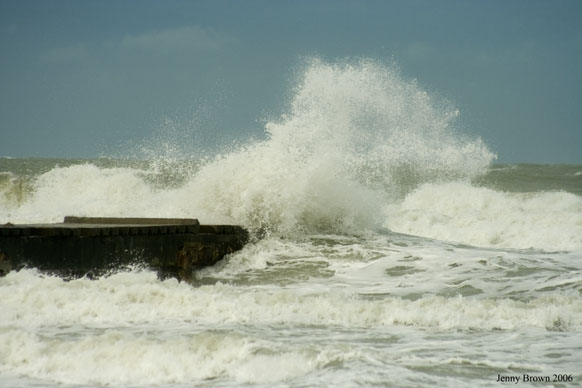
|
|
|
Quote:
If you are in a MANDATORY EVACUATION AREA.
And The MANDATORY EVACUATION has been issued Today.
I certainly hope that you have left and are viewing this from a Safe place.
I'll have to check on the Mandatory Evacuation specifics. But from the information that I have.
It looks like parts of Pasco, Hernando, Citrus, Levy, Dixie and Taylor probably have some type of evacuation order in place now.
Add Hillsborough, Pinellas, and Manatee to the above list.
I'm basing the above list on predicted Surge Heights. So I need to check the forecast heights against the Evacuations.
Where did you see evacuations for Manatee county? I live in Manatee and have'nt hear of any kind of evacuation.
| Unregistered User |
| (Unregistered) |
| Mon Jun 12 2006 11:58 PM |
|
|
No change in the 7pm.
| Randrew |
| (Weather Guru) |
| Mon Jun 12 2006 11:59 PM |
|
|
|
|
I see no change here in intensity. I could only assume we still have a Tropical Storm to deal with. The only question now is intensity and where at landfall?
http://www.nhc.noaa.gov/text/refresh/MIATCPAT1+shtml/122354.shtml
| Unregistered User |
| (Unregistered) |
| Tue Jun 13 2006 12:03 AM |
|
|
According to heraldtoday.com "Emergency officials in Manatee say expected storm surge not serious
"
They are only expecting some street flooding on Anna Maria Island.
heraldtoday.com
| Ronn |
| (User) |
| Tue Jun 13 2006 12:05 AM |
|
|
|
|
Quote:
So.....have we seen the bulk of what we are going to see here in the Tampa area?
We won't have another extended period of rain like this morning, but we will have on and off squalls through the night; and our winds will ramp up to 40-50mph in gusts by midnight. Most significantly, onshore winds from the SW will generate coastal flooding in the typical spots, such as Shoreacres in St. Pete. This reminds me of Tropical Storm Josephine in 1996, although I don't think that the coastal flooding will be as bad. I recall a windy night with 45mph wind gusts and occasional rain squalls.
The winds have increased substantially during the last hour here at my house, after being very calm most of the day. I've recorded a gust of 25mph. With the storm moving closer overnight, 40-50mph gusts seem reasonable. My rainfall total up to this point is 2.6 inches.
| BIGBLOW |
| (Registered User) |
| Tue Jun 13 2006 12:14 AM |
|
|
WELL IAM COVERING THE WEST PASCO AREA FROM HOLIDAY TO PORTRICHEY...
ITS SEEMS YO
U DONT GET MUCH INFO FOR WEATHER IN THIS AREA ...WHAT SHOULD WE EXPECT HERE?RIGHT NOW
72 RAIN SE WIND 10 TO 20
| madmumbler |
| (Storm Tracker) |
| Tue Jun 13 2006 12:16 AM |
|
|
|
|
Quote:
As of right now, there is no reason to close the bridges as the winds are not that high. Having said that, I would not be surprised if FHP closes the bridges later today/tonight as the storm approaches the TB Area and the gusts in the feeder bands will be at and above TS force winds.
I think BayNews 9 also mentioned a few minutes ago that the timing of landfall may move up. I'm not exactly sure *why* they said that, as I just caught that part of the conversation. They, too, are concerned about Bay Area bridges.
I crossed the Skyway (going south) around 4pm and it wasn't nearly as bad as I thought it would be. I had harder wind gusts going over that little Misener bridge to the north of it. The How-weird Franklin was blustery and the bay was choppy near it.
| madmumbler |
| (Storm Tracker) |
| Tue Jun 13 2006 12:19 AM |
|
|
|
|
When I got home tonight around 5:30 or so, I found that since noon yesterday (Sunday) and then, we've only had a total of TWO INCHES of rain. That's it. What a disappointment in the rain department. We really need a drought-buster down here, and that certainly helped, but not nearly enough to help fix the water tables.
| VandyBrad |
| (Weather Hobbyist) |
| Tue Jun 13 2006 12:22 AM |
|
|
|
|
I had not seen this posted earlier today, so I thought I'd let everyone know that the University of Florida has officially cancelled all activities for tomorrow.
| Bill-n-StPeteFL |
| (Verified CFHC User) |
| Tue Jun 13 2006 12:22 AM |
|
|
quote]
Quote:
So.....have we seen the bulk of what we are going to see here in the Tampa area?
We won't have another extended period of rain like this morning, but we will have on and off squalls through the night; and our winds will ramp up to 40-50mph in gusts by midnight. Most significantly, onshore winds from the SW will generate coastal flooding in the typical spots, such as Shoreacres in St. Pete. This reminds me of Tropical Storm Josephine in 1996, although I don't think that the coastal flooding will be as bad. I recall a windy night with 45mph wind gusts and occasional rain squalls.
The winds have increased substantially during the last hour here at my house, after being very calm most of the day. I've recorded a gust of 25mph. With the storm moving closer overnight, 40-50mph gusts seem reasonable. My rainfall total up to this point is 2.6 inches.
Yes I notice the winds becoming more steady here in St Pete in the last hour myself.
| madmumbler |
| (Storm Tracker) |
| Tue Jun 13 2006 12:22 AM |
|
|
|
|
Quote:
WELL IAM COVERING THE WEST PASCO AREA FROM HOLIDAY TO PORTRICHEY...
ITS SEEMS YO
RIGHT NOW
72 RAIN SE WIND 10 TO 20
I was actually up there in Bayonet Point today around 1pm after my son's appointment in St. Pete this morning.
If you are west of 19 and in an area that floods, especially if it flooded during the No-Name storm in '93, then you need to think about evacuating if you have been asked to do so. I can't remember if "zone A" was asked to leave or not.
If you are east of 19, and not in a low-lying area or on a canal/Cotee river, you will most likely be fine. BUT you need to check out local emergency management's website for any updates.
| madmumbler |
| (Storm Tracker) |
| Tue Jun 13 2006 12:25 AM |
|
|
|
|
Quote:
According to heraldtoday.com "Emergency officials in Manatee say expected storm surge not serious
"
They are only expecting some street flooding on Anna Maria Island.
heraldtoday.com
My dh works for Sarasota county and the EOC wasn't activated today. (He has to be there when it is.) They are in stand-by mode or whatever they call it. They aren't expecting any major problems either.
I would say there's a potential for some beach errosion and possible low-lying area flooding IF the winds are strong enough, but not on a massive scale. Just my opinion.
| berrywr |
| (Weather Analyst) |
| Tue Jun 13 2006 12:39 AM |
|
|
|
|
LLC is exposed, and Alberto more and more looks like a hybrid system now, and I simply see no evidence he'll become a hurricane. Latest Vortex message, supports a weaker storm, though their maintaining 60 knots. Max FL winds were 52 and 44 knots. I look to see the system become dynamic with baroclinic processes as upper environment becomes more hostile. There is one mediating circumstance; Alberto's forward motion which will help against shear, but I see no evidence of this on satellite and vapor imagery.
| Ned |
| (Weather Watcher) |
| Tue Jun 13 2006 12:34 PM |
|
|
Quote:I knew Tampa would get it,but from the east??
I looked at both loops posted and on the high-resolution visible satellite being shown on BayNews9, it appears that there is another center trying to form almost due east of Tampa Bay. This is not just my opinion, this was pointed out by Alan Winfield and it's very easy to see. Perhaps what we thought was Alberto falling apart was Alberto re-organizing himself - again.
5pm Advisory out: still a Tropical Storm w/ winds of 70mph. Did not hear any other updates; that's all they had to offer.
