| JMII |
| (Weather Master) |
| Tue Oct 18 2022 09:58 AM |
| Attachment |

|
|
|
Quote:
Your roof is intact. I see no damage to the shingles.
You can't see it but the front half (south facing) roof shingles were ripped off.
All the downed trees I saw in Cape Coral were tipped over to the WSW telling me things were worse wind wise on the backside. This is what I experienced in Wilma too in NW Broward. I fully believe the eyewall winds were more inline with 120 MPH not 140-160 or some of the insane 180 "estimated" gusts some were claiming.
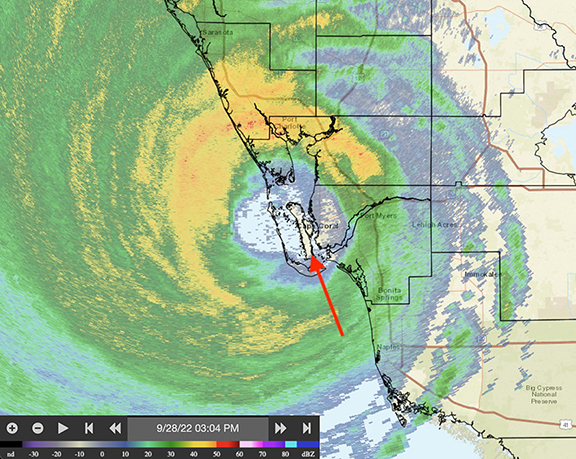
Arrow on the radar image is location of pictures above. Comparing this image against the localized damage I think the direct hit might have been a minor blessing since St James got the front and back of the eyewall with a period of calm in between. In contrast areas like Ft. Myers Beach were in the S eyewall the entire time, it never let up even after landfall. Downtown Ft. Myers flooded due to the ocean water pushing up the river where it getting funneled into a narrower space forcing it higher and higher. The radar also shows why the surge was bad down S in Naples, they too never saw a break from the onshore flow until Ian was halfway across the state. Everyone N of the eye experienced offshore flow and thus no surge at all.