CFHC
|
| () |
| Wed Sep 04 2002 12:34 PM |

|
|
|
This will be updated during the day as more information on Edouard is made available.
Noon Update
Minimal Tropical Storm Edouard has been drifting west southwest over the past couple of hours, however, high pressure aloft over the eastern Gulf has been building eastward during the night and should change the movement of Edouard to a more southwesterly direction.
This will place the center of the storm north of the Cape near Daytona Beach later this evening.
Some additional intensification is likely before landfall, so Edouard should retain its Tropical Storm status.
The Position at 11am was near 30Nand 80W.
Most of the rain and stronger wind associated with this system are located to the east and south of the center, and northwesterly upper level wind shear continues to disrupt the cyclone. Late this evening into Thursday, west to northwest winds will approach tropical storm force along the coast.
Squalls with heavy downpours are likely to start as early as this afternoon, becoming more frequent tonight and Thursday along the central and north Florida coast. The National Hurricane Center has issued a Tropical Storm Warning from Titusville northward along the Florida coast and a Tropical Storm Watch from Titusville southward to Sebastian Inlet.
The storm in the northern gulf is coming together, but the situation with Edouard and the rest makes any real forecasting a nightmare still for a bit longer.
Noon update special thanks to Ed Dunham.
8:30 AM Update
Edouard weakened quite a bit yesterday and much of the convection was sheared off to the east, but this morning it appears that it may be refiring a bit. I think it'll maintain itself as a tropical storm for a while longer. Rain from the storm is being felt along the coastal edge of Volusia now. But the storm itself is still offshore about 80 miles slowly moving. The last public advisory from the NHC stated the windspeed at 40MPH, but new Aircraft Recon reports that occured after the advisory now show it at 50MPH.
The fact that it is over extremely warm water has kept the system from outright dying because of the massive amount of shear it has been receiving. This storm is a survivor, any chance to strengthen it can get, it will take. However, there will not be that many chances for it io do so. I expect it to weaken again later in the day... but maintain itself as a tropical storm.
If the official track holds it'll reach the coast in the overnight hours tonight, and the rain will occur mostly on the eastern side of the system. (This all could change however....) Plenty of folks around the St. Johns really don't need the rain.
Updates will occur today here as needed.
Outside of Edouard, the system in the east atlantic is getting some shear that will keep its developmental possibilities in check for a while (although there is a wave over africa now that may slide out fairly strong later).
Also the Northern gulf is active, but still nothing at the surface. This is one to watch as well, but it still will take a while. Once this does get going, however...
NRL Monterey Marine Meteorology Division Forecast Track of Active Systems (Good Forecast Track Graphic and Satellite Photos)
NASA GHCC Interactive Satellite images at:
North Atlantic Visible (Daytime Only), Infrared, Water Vapor
Some forecast models:
NGM, AVN, MRF, ETA ECMWF
DoD Weather Models (NOGAPS, AVN, MRF)
AVN, ECMWF, GFDL, MM5, NOGAPS, UKMET
Other commentary at Mike Anderson's East Coast Tropical Weather Center, Accuweather's Joe Bastardi, Hurricane City, Gary Gray's Millennium Weather, Barometer Bob's Hurricane Hollow, Snonut, Ed Dunham and Jason M in our Storm Forum Even more on the links page.
- [mike@flhurricane.com]
| ShawnS |
| (Storm Tracker) |
| Wed Sep 04 2002 12:40 PM |
|
|
Anyone see a chance of anything developing from the stuff in the northwest gulf? I've been trying to see if there is a motion out of it but it looks like it is stationary. I know the focus is on Eddie right now, but this activity in the gulf could really spring up on us in a hurry. I'm not saying it will, but every time I look at a new sat. pic. it looks more impressive.
| PFSThunder |
| (Weather Watcher) |
| Wed Sep 04 2002 12:53 PM |

|
|
|
Looking at the long range radar out of Melbourne, it looks like the center is wrapping tightly west of St Augustine. Last night the signature was wider, now the bandsfeeding the system are closer together. Something to be watched. Weather service being very careful with any changes to the forecast.
| squirralee |
| (Weather Hobbyist) |
| Wed Sep 04 2002 01:01 PM |

|
|
|
Okay am I crazy or is the GFDL trying to put another tropical system off the coast of Brevard after Ed goes over the state.
http://www.essc.psu.edu/rhart-cgi-bin/gfdltc2.cgi?time=2002090406-edouard05l&field=Sea+Level+Pressure&hour=Animation
| Jax Chris |
| (Weather Watcher) |
| Wed Sep 04 2002 01:32 PM |
|
|
I've always liked the central pressure for a predictor of how the intensity of a storm is going to go. The lower the pressure, the more rapidly the storm's moving air up its core, and so the more rapidly air has to flow into the storm to replace that air. Yesterday we saw the pressure drop down to 1003, followed by an increase in intensity. The pressure went back up, and wind speeds dropped. The 2 a.m. recon had the central pressure down to 1002, where it's remained even up through the 8 a.m. recon. So we've got the pressure and a flare-up of convection on the plus side, and the shear on the minus side. Despite the NHC forecast of weakening before landfall, I suspect Edouard has a good chance of strengthening. Hopefully, however, the shear will win out before Edouard gets to the coast.
Chris
| Unregistered User |
| (Unregistered) |
| Wed Sep 04 2002 01:32 PM |
|
|
I don't think so, but it's putting a major hurricane in the Mobile/Pensacola area. Probably a bit overdone, but the track is feasible.
| Colleen A. |
| (Moderator) |
| Wed Sep 04 2002 01:43 PM |

|
|
|
A few things I've noticed about Ed...TWC was VERY CERTAIN earlier that he would be almost dead by the time he reached the coast. Now they are backing off of that statement. Eduardo has pretty much stalled off the coast of Central Florida, looks better and doesn't have a definite movement that one can follow for any length of time (say, like 5 minutes), so....we don't know what he's doing or when he is gonna do it, and how strong he will/won't be if he keeps this type of behavior up. Nothing is ever a sure bet when it comes to tropical weather and if he was getting closer to the coast I would say that a certain forecast could be right but the very fact that he's 90 miles east just sitting there barely moving does give him time do something.
We just have to wait and see what that "something" is. Hopefully, we will know that before my kids start college.
| Unregistered User |
| (Unregistered) |
| Wed Sep 04 2002 01:45 PM |
|
|
Eduardo should be downgraded soon, 1006 presure and only 25K winds,,,damn hes weak. Oh well which system is next????? Maybe we can all fly planes westward ahead of him causing the winds briefly to turn w in the upper level and watch him go up briefly 5 mph,LOL jk anyways if he makes it to the gulf the shawn will at least ask a new question every 5 min about hitting Houston.
| troy2 |
| (Storm Tracker) |
| Wed Sep 04 2002 01:58 PM |
|
|
In reply to:
Okay am I crazy or is the GFDL trying to put another tropical system off the coast of Brevard after Ed goes over the state.
I saw the same thing. Small set of closed isiobars within the circulation of Edouard. It is an interesting thing. Not sure what it is, though doubt its a new sytem
| StormHound |
| (Weather Guru) |
| Wed Sep 04 2002 01:59 PM |
|
|
The 24kts is for the SW quad, not the center. The NE quad was tagged at 43kts an hour or two ago. I don't think Ed is weakening yet.
As far as the GFDL, yes there is a swirl at the end of the GFDL loop, but it would not be strong enough to be considered even a TD.
| Cycloneye |
| (Storm Tracker) |
| Wed Sep 04 2002 02:17 PM |
|
|
Against all the shear it has encountered still the storm manages to hang on and complicate the forecasts of the models and the folks of the TPC.
| Unregistered User |
| (Unregistered) |
| Wed Sep 04 2002 02:21 PM |
|
|
Eddie looks to have lost some of his signature in the past hour. I am having a hard time picking out the center on radar or sat. It was very clear earlier this morning. I believe the weakening has continued.
| Unregistered User |
| (Unregistered) |
| Wed Sep 04 2002 02:34 PM |
|
|
>>jk anyways if he makes it to the gulf the shawn will at least ask a new question every 5 min about hitting Houston.
Maybe he will, but he doesn't hide behind the anonymous tag when asking those questions or making pointed comments.
Hey Shawn,
I don't know what's up down there. There is obviously some low pressure at the surface, but there really aren't any buoys near where it probably is centered (elongated south of New Iberia/Franklin over toward Corpus/Kings Ranch). All the surrounding buoys show fairly high pressure including here in the city. Most of the pressures are up from yesterday by .02-.04 and are ranging from 29.91 to 30.3. So your guess is as good as mine. I fully expect to wake up tomorrow again and see blossoming convection. But what is the ultimate solution?
Steve
| Unregistered User |
| (Unregistered) |
| Wed Sep 04 2002 02:51 PM |
|
|
From the looks of the recent sattelites I believe we will at least get an invest out of this. BarryB
| Unregistered User |
| (Unregistered) |
| Wed Sep 04 2002 03:22 PM |
|
|
Looks like the tpc is getting interested also
| HanKFranK |
| (User) |
| Wed Sep 04 2002 03:34 PM |

|
|
|
shawn, nhc is talking in the 11am outlook like the system off tx/la may develop. the 00zavn has something going out there, which absorbs edouard down the road. avn also stalls it offshore, but this is probably poor initialization (though this thing HAS been sitting off the coast for a couple of days). seeing as edouard is getting the nw outflow jet right across the top, and that system has parts at least that are under a large well defined upper ridge.. yeah, if that thing starts developing it could really wreck all the forecasts.
dolly has been decoupled, now a low cloud swirl in a hostile environment. dont count it out until totally dissipated though.
somebody mentioned that gfdl has another system behind edouard.. this is complicated. a number of models have been suggesting that a low would form south of bermuda due to an amplification, the one that was supposed to insure dolly's exit. some models loitered it, some split it, some jetted it out to the northeast. and some caught it under the building ridge. now this morning i see a slightly turning disturbance out in the general area, sheared and beaten as edouard was.. have to see if it persists.. i've been expecting something around there.
95L still has no deep convection but not any weaker. water temps underneath wont be at 26C until later on today, but it is moving towards the ridging ahead of dolly's killer trough. you know what i'm implying might happen..
can see the weak swirl to the ssw of 95L on visibles this morning, drifting west around 13N38W. 95L is caught in the mid layer flow and is going to breeze by to the north.. leaving this persistent swirl in its wake. it is still associated with convection, and waters down there are quite a bit warmer.
final note: bastardi says the next wave is energetic. 10W he said.. that means it comes out some time tomorrow.
so thats it.. four disturbed areas.. probably two will give us new storms.
HF 1531z04september
| Unregistered User |
| (Unregistered) |
| Wed Sep 04 2002 03:38 PM |
|
|
plane going in this afternoon
| Unregistered User |
| (Unregistered) |
| Wed Sep 04 2002 03:42 PM |
|
|
????????
| Unregistered User |
| (Unregistered) |
| Wed Sep 04 2002 03:59 PM |
|
|
I was wondering about that. With all the planes flying around in Edouard you'd think that they would send something into the GOM area that is looking most interesting.
I was thinking Fay in the Gulf and Gustav out in the Atlantic.
Interesting thoughts a few posts back Hank I think, thanks Bobbi
| Unregistered User |
| (Unregistered) |
| Wed Sep 04 2002 04:02 PM |
|
|
As for that model run just now.. beats me what its trying to do but imagine it could only happen if when exiting Florida Edouard (happy to get away from Florida) becomes a much stronger system.
Could maybe see Edouard wandering around A1A and being pulled west by a strong storm in the Gulf but the timing looks off
| doug |
| (Weather Analyst) |
| Wed Sep 04 2002 04:17 PM |
|
|
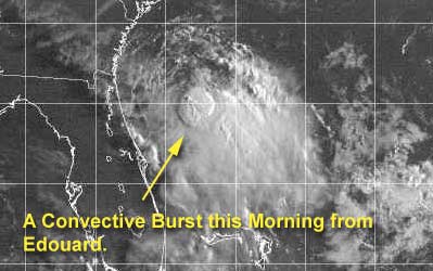
HF- the visible confirms the Western GOM system is coming together, and you are so right that the further development and track even of Eduard is being influenced byt the outflow jet from that system...the convective burst in Eduard this morning has already been blown about 75 miles south of the center...no real convection hanging around now cemter still moving a little south of west slowly.
The Gom system may be showing drift to north? if tit moves inland before Eddie , the little eddie may still have a chance to grow , but so far the system to the west is inhibiting further development.
| Mary K. |
| (Weather Guru) |
| Wed Sep 04 2002 04:17 PM |
|
|
Can anyone estimate the direction that edourd might take with a new system in the Northern Gulf? would pull Ed north or push him south?
| StormHound |
| (Weather Guru) |
| Wed Sep 04 2002 04:18 PM |
|
|
Eddie:
Latest recon (04/1403Z, 9AM ET?) shows maximum flight level winds of 45kts. This would be up from previous recon and about 10mph more than the official 40mph. Still getting hammered, but holding his own. If he can get into the Gulf he could be impressive.
NW GOM: Looking better and better. Can't wait to see the recon.
| Rasvar |
| (Weather Master) |
| Wed Sep 04 2002 04:30 PM |

|
|
|
Wow. Deja Vu. Looks like yesterday all over again. Shear taking over and ripping convection away. Here we go again.
| Unregistered User |
| (Unregistered) |
| Wed Sep 04 2002 05:11 PM |
|
|
HF,
The wave SW of 95L certainly looks interesting in the NRL 1600z sat pic...even more interesting than 95L itself. Has gained convection during the morning. With better conditions down there, is it possible to have the next one shortly?
cc
| Unregistered User |
| (Unregistered) |
| Wed Sep 04 2002 06:04 PM |
|
|
000
WTNT35 KNHC 041738
TCPAT5
BULLETIN
TROPICAL STORM EDOUARD INTERMEDIATE ADVISORY NUMBER 12A
NATIONAL WEATHER SERVICE MIAMI FL
2 PM EDT WED SEP 04 2002
...EDOUARD CONTINUES WESTWARD...
A TROPICAL STORM WARNING REMAINS IN EFFECT FROM TITUSVILLE FLORIDA
TO BRUNSWICK GEORGIA.
A TROPICAL STORM WATCH REMAINS IN EFFECT FROM SOUTH OF TITUSVILLE TO
SEBASTIAN INLET FLORIDA.
AT 2 PM EDT...1800Z...THE CENTER OF TROPICAL STORM
EDOUARD WAS LOCATED NEAR LATITUDE 29.8 NORTH...
LONGITUDE 80.5 WEST OR ABOUT 50 MILES EAST-SOUTHEAST OF ST.
AUGUSTINE FLORIDA.
THE FORWARD MOTION OF EDOUARD HAS BEEN ERRATIC. OVER THE PAST FEW
HOURS IT HAS BEEN MOVING TOWARD THE WEST NEAR 8 MPH. A WEST OR
WEST-SOUTHWEST MOTION AT A SOMEWHAT SLOWER SPEED IS EXPECTED OVER
THE NEXT 24 HOURS. THE CENTER OF EDOUARD IS EXPECTED TO REACH THE
COAST WITHIN THE WARNING AREA LATE TONIGHT OR EARLY THURSDAY.
MAXIMUM SUSTAINED WINDS ARE NEAR 40 MPH... 65 KM/HR...WITH HIGHER
GUSTS. LITTLE CHANGE IN STRENGTH IS FORECAST DURING THE NEXT
24 HOURS.
TROPICAL STORM FORCE WINDS EXTEND OUTWARD UP TO 70 MILES...MAINLY
EAST OF THE CENTER.
THE MINIMUM CENTRAL PRESSURE MEASURED BY RECONNAISSANCE AIRCRAFT WAS
1009 MB...29.80 INCHES.
RAINFALL ACCUMULATIONS OF 2 TO 4 INCHES...WITH LOCALLY HIGHER
AMOUNTS...ARE EXPECTED NEAR THE PATH OF EDOUARD.
ISOLATED TORNADOES ARE POSSIBLE IN SQUALLS NEAR THE COASTLINE.
REPEATING THE 2 PM EDT POSITION...29.8 N... 80.5 W. MOVEMENT
TOWARD...WEST NEAR 8 MPH. MAXIMUM SUSTAINED
WINDS... 40 MPH. MINIMUM CENTRAL PRESSURE...1009 MB.
FOR STORM INFORMATION SPECIFIC TO YOUR AREA...PLEASE MONITOR
PRODUCTS ISSUED BY YOUR LOCAL WEATHER OFFICE.
THE NEXT ADVISORY WILL BE ISSUED BY THE NATIONAL HURRICANE CENTER AT
5 PM EDT.
FORECASTER FRANKLIN
| Unregistered User |
| (Unregistered) |
| Wed Sep 04 2002 06:05 PM |
|
|
You can clearly see the "W" motion in the visibles at NOAA. However, I didn't even post it an hour ago when I saw the loop because, well, I was chicken that it was going to go somewhere else.
LOL.
Steve
| Unregistered User |
| (Unregistered) |
| Wed Sep 04 2002 06:06 PM |
|
|
Where Ya At Greg B. ???? Sean??? Steve???? What is you guys opinion? On the Gulf
| ShawnS |
| (Storm Tracker) |
| Wed Sep 04 2002 06:14 PM |
|
|
Just came home on my lunch break and...WOW! I've been trying to catch up on the reading and to be honest, I don't like what is setting up here. Remember, I said I just wanted a small storm for a little excitement. Everything I have been able to read says that this thing could sit out there for several days. The only positive about that is that the longer it sits out there the less more likely that it will be pushed away from my area. The down side to that is someone would have to feel the effects of it. This COULD be setting up for a pretty serious situation. However, I will wait a bit longer to go out and buy supplies because we all know how these things can just fall apart.
| Cycloneye |
| (Storm Tracker) |
| Wed Sep 04 2002 06:48 PM |
|
|
http://www.nrlmry.navy.mil/tc-bin/tc_home
This is for the WGOM system that is slowly organizing amd all residents of the gulf coast of Texas and Louisiana should monitor the progress of this developing system.
| HanKFranK |
| (User) |
| Wed Sep 04 2002 06:56 PM |
|
|
|
|
nrl has an invest on the gulf system. it is initialized as a 25kt/1012mb system at 27.5/94. of course this it is clearly very broad and will probably be one of those multiple-center systems as it organizes due to the broad envelope and the spread of clustered convection. but yeah, be interesting what recon can find. probably a slow mover.
edouard is going ashore later today if it keeps the westerly jog up. the convection hasnt peeled away like yesterday during the day.. and the less vicious shear is ahead on edouard's path. so i can see it getting into the gulf late in the week. to complicate things the center is tracking due west, which if continued would keep it over land longer and emerge it in apalachee bay, only to skim the panhandle (expect more erratic motion). how well edouard survives the crossing of florida is another issue. and then whatever is developing further west adds another layer to the problem. one interesting possibility: two active named systems in the gulf. though edouard will probably not arrive at tropical storm strength.
cc you mentioned the system the 95L is passing to the north of. i dont think it looks as good in terms of the strength of its circulation, though, if the passage of 95L doesnt disrupt it will be in a better place to cause trouble. 95L itself is going to hit pass under the ridge upstream of dolly's demise and intensify to a named system, then start getting ripped at by whatever is left of the trough. considering how strong the westerlies are across most of the basin i wouldnt expect much of 95L in terms of threat. should it play chicken with the shear jet though, i wouldnt totally discount it.
heads up flagler county, here comes edouard. in other words, enjoy the rain squalls.
fay and gustav probably around the corner. maybe even hanna.
HF 1851z04september
| Frank P |
| (Veteran Storm Chaser) |
| Wed Sep 04 2002 07:00 PM |
|
|
My take for what it's worth...
If Edouard continues on its present motion, and survives the trip across Florida, then I think that system will pose a greater threat to the North Central Gulf area.... This has been an amazingly persistent system and has overcome some significant obstacles just to stay alive (dry air/shear).... IF it gets into the GOM as a depression, then my money is on Eddie.... the only negative thing about this scenario is that its what the GFDL predicted several days ago... and I would hate to start thinking that these models can actually be right once in a while... althought is has been off on the intensity and timing...
Now the GOM.... very impressive convection all afternoon but data buoy not suggesting anything eminent... only one buoy reading winds greater than 20K and pressures not nearly as low today as yesterday... I guess it all depends on where and if a definable center developes... closer to the TX shoreline the less chance for any thing major to develop... center develops a couple hundred miles out in the NE GOM, then it has a better chance to crank... Regardless, it should be quite a rain maker for SE TX and LA... little if any impact on MS/AL/FL at the moment... I still am having a hard time trying to pinpoint a center, best I can tell is that is off the TX coast in the western GOM, but I don't have a lot of confidence on that location...
| Unregistered User |
| (Unregistered) |
| Wed Sep 04 2002 07:10 PM |
|
|
96L is born in the minds of naval personnel. No idea what it's gonna do. Maybe play tug of war with Edouard for energy? I don't know. New run of CMC less menacing all the way around. 00z release of MM5 more concern for TX as the 'circles' actually turn to light blue toward the end of the period - remaining off the S TX Coast the entire time.
Steve
| doug |
| (Weather Analyst) |
| Wed Sep 04 2002 07:18 PM |
|
|
The GOM low has indeed been repressing Eduard all week so far, but the outflow seems to have lessened and/or shifted to the west a bit...that should bode for strengthening of Edouard, BUT it is now only a few miles east of the upper Volusia county coast line and is definitely going to make a land fall today there...it seems to be moving more rapidly than 3mph, and as many of these systems do may scoot quickly across the peninsula, I see some indications that a feeder band is beginning to form showers in the SE GOM with the line going across the Lee county area and up to the storm itself...check the NWS-Melbourne longrange loop...IF the NW GOM system weakens or moves ashore, then Eduard may become more formidable on the GOM side of Florida in the next couple of days...
| Unregistered User |
| (Unregistered) |
| Wed Sep 04 2002 07:33 PM |
|
|
The westernmost tropical wave has lost definition east of the Texas coast. Surface observations from ship and buoy reports show a weak low pressure area located about 27 north and 96 west. This low pressure area has been in place for the past couple of days with no big pressure falls just yet, but is being watched very carefully. It should stay over water for the next 24 hours. That will give it plenty of time to spin up into a more organized feature and become a tropical system. Steering currents over the system are very weak, so any feature that tries to evolve out of this broad area of low pressure will be a very slow mover, similar to Edouard.
| Unregistered User |
| (Unregistered) |
| Wed Sep 04 2002 07:46 PM |
|
|
Bouy south of galveston has 25 knots sutain gust to 29.1 knots last hour
| Unregistered User |
| (Unregistered) |
| Wed Sep 04 2002 07:49 PM |
|
|
Convection bursting to sse of center of E, moving in closer to the center--thank God we've got 40kts of shear!
IHS,
Bill
| Unregistered User |
| (Unregistered) |
| Wed Sep 04 2002 07:50 PM |
|
|
Less strengthening, but a return to a SE LA landfall tradjectory. The initialization of that model is now 7 hours old and had the storm much further NE than what it is now. I'd love to see some current model initializations.
Steve
| Kevin |
| (Weather Master) |
| Wed Sep 04 2002 08:01 PM |

|
|
|
Edouard may only have winds of about 35 knots, but from the looks of the latest IR, WV, and visible satellite loops, it looks as if Central Florida is going to get pounded by torential rains and wind gusts to 50 mph or so. Not only on the coast but also inland. Edouard should move across the state at 10-12 mph. That may be quicker than the 3-5 he was orginally doing but 10-12 isn't race car quick. That pretty slow in fact and because of this the flood threat is probably very high for the St. Johns River and moderate to high in other locations. A couple of isolated tornadoes and waterspouts possible tonight. It doesn't always take a major hurricane or a hurricane at all to produce dangerous conditions...and I believe tonight will prove that here in East Central Florida.
Conditions in southwest Seminole County, Florida:
Cloudy
On and off light rain
Winds gusting to 15 mph occasionally
Strong convective activity (squalls) approaching from east
I'll update you next whenever I can (should be pretty soon). I guess I'll see how bad or good it is tonight.
Kevin
| Unregistered User |
| (Unregistered) |
| Wed Sep 04 2002 08:06 PM |
|
|
http://seaboard.ndbc.noaa.gov/station_page.phtml?station=41009
Tells us that the winds are up, and the pressure is falling fast! -.09 and falling
| Unregistered User |
| (Unregistered) |
| Wed Sep 04 2002 08:13 PM |
|
|
You getting excited?
Steve
| Kevin |
| (Weather Master) |
| Wed Sep 04 2002 08:15 PM |
|
|
|
|
NWS forecast discussion in Miami indicated something that the Melbourne one didn't indicate: A flood watch in being is issued for portions of SOFLA at this time and Melbourne is likely going to put up a flood watch for all of ECF at 5:00 PM. A wait and see thing.
Looks like this storm is going to be a bit more intense than some expect. Could even surprise a few given its current organization.
Weather in southwest Semionle County, Florida
Mostly Cloudly
Winds gusting to 15 mph
No recent rain
RE Steve: Yes, I'm getting a bit excited over what may occur tonight.
Kevin
| Unregistered User |
| (Unregistered) |
| Wed Sep 04 2002 08:23 PM |
|
|
Agree, Kevin definite flooding potential. Waiting on it over here in Tampa area to see what comes. Hope it doesn't stall over state or in East GOM. WOW, did you see the blowup of convection?
| Rasvar |
| (Weather Master) |
| Wed Sep 04 2002 08:25 PM |
|
|
|
|
Melbourne had it in there, just lost in a large discussion:
"WITH THE OVERALL SLOW MOTION OF THIS SYSTEM...FAVORED UPPER LEVEL
FORCING...AND HIGH MOISTURE PROGGED TO RETURN...HAVE DECIDED THAT A
FLOOD WATCH IS NECESSARY...ESPECIALLY GIVEN THAT THE ST JOHNS RIVER
IS NEAR BANKFULL IN SEVERAL LOCATIONS. "
This is going to be a rain dumper on central Florida. Hopefully, it will hit the areas that can handle it with drainage. I'm a little worried. Saw my road flood in a deluge a few days ago. Ditches are very slow to drop right now. Not sure how much they can handle. Hoping to get no more then 5" of rain out of this max. These slow movers can be killers. The UKMET worries me. If Ed stalls out over Central Florida for a bit before backing out over the Atlantic or passing into the Gulf, it could be boat time in Central Florida.
| Floridacane |
| (Weather Guru) |
| Wed Sep 04 2002 08:30 PM |

|
|
|
I'm not excited. We don't need anymore rain, and it's getting very ominous here in Southern Brevard. The skies are starting to get ugly, but at least there aren't any winds.
| Unregistered User |
| (Unregistered) |
| Wed Sep 04 2002 08:37 PM |
|
|
OK, is it my imagination (yes) or has edie's center opened up into a broader circulation. If you look at the western bands that are inland, it looks as if they've stalled (not making westward progress). Could Eddie stall just before landfall?? Cheers! Steve H.
| Unregistered User |
| (Unregistered) |
| Wed Sep 04 2002 08:42 PM |
|
|
Is it that or did it open up at landfall. Eddie may be dead. What a trooper he has been though.
| Unregistered User |
| (Unregistered) |
| Wed Sep 04 2002 08:54 PM |
|
|
I live on N. Merritt Island (a few miles exactly due west of the cape) and we have been getting pounded. Thunder and lots of rain...
| Unregistered User |
| (Unregistered) |
| Wed Sep 04 2002 08:58 PM |
|
|
Nope...there is still a circulation..it is broad..it is kamking progress to the west, or just south of west, heavy weather along the coast in the Brevard county area...actual center still just off shore...my question is , nd these weak systems do strange things, will the center try to pull it self under the big cloud mass to the south? it looks like the jet that has been over it has shifted west, but still shear from n to south.
| Floridacane |
| (Weather Guru) |
| Wed Sep 04 2002 09:00 PM |
|
|
|
|
I live in Melbourne, and it has definitely started to get active here. Rain, some gusty winds,lightning etc. I have a feeling its gonna be a long, rainy yucky night!!!
Hope everyone stays dry. Good night to stay home with family and play board games!!
| Mary K. |
| (Weather Guru) |
| Wed Sep 04 2002 09:01 PM |
|
|
So far Eddie looks no more threatening than our usual afternoon variety summer thunderstorms. The winds and rain from those types of storms can be rather exciting for a few hours. 5 inches in all this sand is not a lot of rain. However, for the rivers that are full it could get pretty ugly. The frames that are being shown on the weather channel do not look like Eddie has officially made landfall yet.
| Steve777 |
| (Registered User) |
| Wed Sep 04 2002 09:24 PM |
|
|
Its been pouring here in St cloud for 30 minutes now yahoooooo gusts and bad lightning too bring it on
| WXMAN RICHIE |
| (Weather Master) |
| Wed Sep 04 2002 09:32 PM |

|
|
|
FLOOD WARNING FOR...
BREVARD COUNTY
IN EAST CENTRAL FLORIDA
* UNTIL 630 PM EDT
* AT 427 PM EDT...WEATHER SERVICE DOPPLER RADAR INDICATED HEAVY RAIN BANDS FROM TROPICAL STORM EDOUARD MOVING ACROSS BREVARD COUNTY FROM
TITUSVILLE TO MELBOURNE. THESE THUNDERSTORMS WILL MOVE SOUTH AT 10 MPH AND CONTINUE TO PRODUCE RAINFALL RATES OF UP TO 3 INCHES IN AN HOUR THROUGH 630 PM.
| WXMAN RICHIE |
| (Weather Master) |
| Wed Sep 04 2002 09:49 PM |
|
|
|
|
Melbourne flood statement mentions 2"-4" of rain from the storm with some areas getting over 4". The new flood warning mentions getting 3" of rain in just the next hour. They better up their grand totals by alot more. Miami is even mentioning areas in South Florida will get 3"-5" with some getting up to 8".
| Kevin |
| (Weather Master) |
| Wed Sep 04 2002 10:00 PM |
|
|
|
|
Partly Cloudy, rapidly transitioned to cloudy
Winds gusting to 10 mph
Squal possibly approaching from north (as seen on radar)
Notes: 10-15 minutes of partly cloudy skies and no winds at all. It was PERFECTLY calm! However, in the last 5 minutes or so the sky has clouded up and the winds have began gusting to 10 mph again. I expect the first squall within 30 minutes to an hour. Rain core still looks to go dead straight through Central Florida in the next 3-10 hours depending on speed and motion.
Tropical depression also forming GOMEX. Should be classified tomorrow afternoon. Could be a moderate tropical storm, greatly depending on how it moves.
Kevin
| Frank P |
| (Veteran Storm Chaser) |
| Wed Sep 04 2002 10:05 PM |
|
|
Interesting to see that the probabilities are slightly increasing for the northern gulf coast in 72 hours out... several days ago Gulfport was at only 2 now its at 10... at the 5pm update probabilities were slightly decreasing towards the east and slighly increasing to the west...
Hey Steve, maybe this one has New Orleans as its target.... still has quite a battle to face with shear and land crossing but hey, could this be the storm the GFDL got right... so far its been relatively close...
the problem with a storm running parallel close to the coast is that it could go inland at any time... so if the system does make it to the GOM and develops... probabilities won't really mean diddily squat.... cause it could strike anywere from PC to NO.. stay tuned gangbecause the excitement in the GOM might be right around the corner...
| HanKFranK |
| (User) |
| Wed Sep 04 2002 10:18 PM |
|
|
|
|
edouard's center has broken out of its earlier westward rush, now drifting sw. change in speed/direction probably in response to the convection blowing up over central florida. best i can tell at this time the center is just north or northeast of daytona beach. pressure there is down to 1010mb, winds out of the west. system will probably take all day to cross the state tomorrow. maybe longer. chance it will survive the crossing maybe 60%. remains to be told if the pulsing convection will continue over land.
nw gulf low 96L still broad and disorganized. low level convergence and conditions aloft are locked in support mode.. all that has to happen is for a low center to take over.
95L is passing north of the disturbance it has been tailing. throwing some spotty convection in on some of its bands. should increase as the system crosses over warmer waters, though shear is never going to fully relax.
system to the south is unchanged, drifting west. may begin to organize tomorrow now as 95L moves away.
HF 2214z04september
| Mary K. |
| (Weather Guru) |
| Wed Sep 04 2002 10:20 PM |
|
|
Polk County
Raining started at 6 pm and thunder with wind gusts exceeding 10 mph at times. Nothing different than our usual so far...
| Chad |
| (Verified CFHC User) |
| Wed Sep 04 2002 10:36 PM |
|
|
N. Citrus cnty...20 miles inland from Cedar Key...
Calm mostly, squall line an hour ago dropped 1/2".
I see the nws probabilities give Cedar Key the highest # for where Ed. may emerge into the Gulf.
It *looks* like it could go farther south.
I think I better drop the pool a couple inches!
| Unregistered User |
| (Unregistered) |
| Wed Sep 04 2002 10:42 PM |
|
|
ed will be gone thursday gulf storm shear will never never let hem do any thing and the gulf storm will do like all the others be to close to land and kill ed the storm that could have been but we have football
| Unregistered User |
| (Unregistered) |
| Wed Sep 04 2002 10:53 PM |
|
|
1.2 inches of rain in Apopka so far today. That's from one band of rain. Cloudy. really calm
| Kevin |
| (Weather Master) |
| Wed Sep 04 2002 11:29 PM |
|
|
|
|
Latest report:
Cloudy with moderate to heavy rain
Winds gusting to 15 mph
BP: 1001.1 mb and falling
There was rain earlier and now we're having some more. If this trend continues I expect two or three quarter inches of rain by sunrise. Squalls continue to increase in frequency and intensity.
Kevin
| Mary K. |
| (Weather Guru) |
| Wed Sep 04 2002 11:35 PM |
|
|
Parts of Polk County getting floodiing rains. We had 3inches of rain in our guage between the last post at 6 and 7 pm. We have not had any let up and another noisy thunder storm is firing up. So it is just a little more rain than usual....
| Unregistered User |
| (Unregistered) |
| Thu Sep 05 2002 12:44 AM |
|
|
YEs DIG ON THAT FOOT BALL !!! ED IZ DEAD!
| Unregistered User |
| (Unregistered) |
| Thu Sep 05 2002 01:17 AM |
|
|
LOL. GFDL's take on 96L is that it moves in over S TX and quickly heads off into the netherworld. In the Edouard 18z, it takes Ed right over Houston. At the same time, it develops something over the BoC and SE FL.
Don't know how it's all gonna work out, but at least there's stuff in the hopper.
Steve
| Unregistered User |
| (Unregistered) |
| Thu Sep 05 2002 01:33 AM |
|
|
http://www.net-waves.net/weather/tropics.php
Killer site that is updated again. For the TX people, click on 96L Invest or Fay (tomorrow). Got all the TPC model plots.
Steve
| ShawnS |
| (Storm Tracker) |
| Thu Sep 05 2002 01:56 AM |
|
|
I don't know what to make of all of this. My heart wants to say ,yea, something is going to "pop" with this one,yet my head tells me that there have been so many of these lately that were in this same position and failed to deliver.The convection had died down with it earlier in the evening but on the last loop I noticed there seems to be a burst of convection that has appeared pretty close to where the center would be. All I know is that it certainly has the eye of all the local mets. here because it is the top story on all the news casts.This is a wait and see type of situation and it is making me crazy.
ShawnS
| Jason M |
| (Weather Watcher) |
| Thu Sep 05 2002 02:00 AM |
|
|
I have updated all of the Atlantic forecast products @ Tropical Weather Watchers after being able to update the site over the last two days. While Edouard appears to be dissipating, we may have another area to watch! Chances of development in the western Gulf of Mexico does appear to be fairly likely. I have updated the Edouard discusssion ont he active storms discussion page and an update on the GOM and the rest of the basin on the detailed atlantic discussion page.
| Unregistered User |
| (Unregistered) |
| Thu Sep 05 2002 03:26 AM |
|
|
Oh god,,,chances in w gulf is like 5%.
| Unregistered User |
| (Unregistered) |
| Thu Sep 05 2002 03:39 AM |
|
|
The latest sat pix do look like some increase in thunderstorms and some tightening @96 Invest. Any thoughts?
| HanKFranK |
| (User) |
| Thu Sep 05 2002 03:53 AM |
|
|
|
|
lessee.. thats bertha, 40mph tropical storm, and edouard, 40mph tropical storm. i shiver at the thought of what the next one will bring.
td edouard, if it keeps the wsw pace up (unlikely) could in theory be over the gulf tomorrow afternoon. for tonight the system will have to get by devoid of convection, so expect whatever reaches the west coast tomorrow to be moribund.
fay this, fay that. system 96L still hasnt focused a low level center, just broad turning and a semicircle of convection. the spot where the greatest surface turning is seems to be west of the upper ridge, so southerly shear is plowing overhead. shear is shear, no matter which way it comes from. have to see if the convection can reorganize tomorrow and try again.
95L throwing a bit more convection. maybe a depression tomorrow. my guess would be it turns north into the central atlantic trough anyhow.
system south of 95L very hard to pick up on. convection spotty but still around at times. moving into a favorable environment, so watching.
several of the globals develop the next african wave outright. pretty sharp upper trough in the far eastern atlantic.. makes this prog sort of iffy. think there is a pretty good chance it will try something.
that is the basin. overnight convection loss makes everything look less promising, more realistic.
HF 0348z05september
| Unregistered User |
| (Unregistered) |
| Thu Sep 05 2002 03:54 AM |
|
|
>>Oh god,,,chances in w gulf is like 5%.
Don't be a wuss. Even if you post anonymous, have a set of testicles and leave a calling card. Chances of gulf not firing are about 5%. The only thing missing right now are pressure falls, windspeed and a distince LLC. Every other ingredient is there. And even it if didn't form, there's a chance for COPIOUS rainfall amounts on the TX coast with a potentially stalled out system.
Be a man or a woman if you're going to be critical and stand up for your opinions.
Steve - yeah, the one in Old Metairie, LA!
| Unregistered User |
| (Unregistered) |
| Thu Sep 05 2002 05:32 AM |
|
|
well Dolly went N as expected though I thought it would of made it to 55W and 20N but was off by 2'deg and passed way east of bermuda as expected.
Eduard downgraded to a TD should bring some moisture to w florida on Thurs as he gets downgraded to a wave very soon. Actually he barely had TS winds at all. Only a down burst of winds when recon was in 2 days ago did they find the winds near 65mph but was barely a TS the whole time due to the strong shear. So basically me calling him 35mph and not a TS would now confirm me saying 8 in the 7-8 storm forcast of the season with 2 cape verdes in which 1 has already happend, then next wont be till near the end of the month.
A possible TD forming from my old forcasted system out of the carribean 2 weeks ago that came into play yesterday picked up moisuture and is now becoming better organized, with strong ridge to its n i expect the TD to move into Mexico or very extreme S Texas later thurs night into friday, so I was 36 hours off from 2 weeks back.
What is next? Well dont believe always in the GFDL but the nogaps and avn is always 2 of the best models. In day 5 a system will break off from a front that will swing in the atlantic around a HUGE RIDGE over the SE US. It will gather strength and move W towards the bahamas early next week. After that there should be no real stoping it from becoming our first hurricane and this will be very simular to Andrew in location but a tad North of there. I expect this to cross florida by next weekend (not this) and go into the gulf then head N into the s gulf states.
Again no nead for alarm since this is 4-5 days out from starting,, all eyes in S texas should watch this possible TD and there is a slim chance it could make TS status but nether the less will bring alot of rains to Corpus south. Scottsvb Hurricaneupdatecenter
| Unregistered User |
| (Unregistered) |
| Thu Sep 05 2002 05:34 AM |
|
|
http://www.cira.colostate.edu/ramm/rmsdsol/RSOMAIN.HTML
Click on latest image IR. Mean blob of convection building @ 12:30am south of Lafayette/New Iberia. Feedback or pulse? Also, wave 'lost' @ 96 came back to life tonight in MX/TX.
Steve
| ShawnS |
| (Storm Tracker) |
| Thu Sep 05 2002 11:21 AM |
|
|
As usual, I wake up this morning and what do I find......NOTHING! Looks like the same old song and dance. I'm beginning to wonder if we will even have a hurricane this year.
| Unregistered User |
| (Unregistered) |
| Thu Sep 05 2002 11:40 AM |
|
|
LOL. Convection about an hour later this morning, but it's cranking.
http://www.ssd.noaa.gov/PS/TROP/DATA/RT/gmex-ir4-loop.html
And based on NWS Radar N.O./BR, it's possible that some heavy rains could be in coastal LA and/or TX today. It's going to be interesting today to see if anything can wrap around one of the (apparent) multiple circulations down there.
Steve
| ShawnS |
| (Storm Tracker) |
| Thu Sep 05 2002 12:01 PM |
|
|
However,I did notice that pressures at almost all the buoys out there are dropping. One I saw had a pressure of 29.82 and still dropping. Still doesn't seem to have a closed low,yet. I reaaly don't think it will ever happen. In fact, I'm wondering if the action pretty much stays over the water and just dies out right there without ever making it on shore.
| Frank P |
| (Veteran Storm Chaser) |
| Thu Sep 05 2002 12:10 PM |
|
|
Old Eddie is a gone pecan... even if it survives the track across FL the NHC is projecting only a 20 mph system to affect the northern gulf coast later this weekend as the eastern GOM is going to blast it with even more high powered shear... Hey, he fought the good fight...... gee, this is our second tropical system (if this comes to fruition) that produced 20 mph winds and tides of 1 foot...
Western GOM looking better this am than last night... I think it will be the only real interesting game in town ... GOM buoy data indicates pressures lowest at 1010.7, so they are starting off lower today than what they were yesterday...... here's the link for a GOM buoy summary
http://www.ems.psu.edu/wx/buoydata/curr/gulfofmex.html
| Unregistered User |
| (Unregistered) |
| Thu Sep 05 2002 12:19 PM |
|
|
If you beileve in tooth fairies, and the European model, Fay may become a depression on Monday. Here's the rather interesting link to Wed.'s model:
http://www.ecmwf.int/products/forecasts/d/charts/deterministic/world/msl_uv850_z500!Wind%20850%20and%20mslp!168!North%20America!12!pop!od!oper!public_plots!latest!/
Steve
| Unregistered User |
| (Unregistered) |
| Thu Sep 05 2002 12:19 PM |
|
|
29.81 and dropping.??
| HanKFranK |
| (User) |
| Thu Sep 05 2002 12:33 PM |
|
|
|
|
before i say anything else, anybody see that low/convective mass that ran up into newfoundland overnight? have to admit it looks better than edouard.
anyhow first off edouard has crossed florida. currently passing back offshore in citrus county, still has a 1011mb low and spotty convection. fierce shear overhead, but this is edouard we're talking about, so it might restrengthen in spite of everything. pretty good chance that ed is dead, though.
96L.. closer in to the shore yesterday, so we get to watch the drama on radar. unfortunately low level center and upper support still have not met the way they need to, so the drama will not happen so much as unfold. pressures are lower than yesterday, slightly, as the system is closer to texas and the lower ambient pressure due to continental heat.
95L throwing convection, heading west. that tells the story. shear probably not going to improve much, so it either develops as is or remains a semiconvective swirl.
system south of 95L still apparent on satelite.. i'm surprised. weak low level circulation near 14/40, drifting west. less convection to work with, but persisting. will watch until it is gone, not expecting anything.. but a good burst might get something going.
next african wave due tomorrow says bastardi. models like, take west, develop. will see.
front with a spinning mcc came off nc coast last night. various models try to develop another low off the east coast this week, in the bermuda triangle area.
that is the tropics. scottsvb have to ask: why do you make a forecast, not have it verify, change it as you go along, and then insist that you called it right? dolly didnt go where you originally forecast, didnt become a hurricane as you first surmised, turned up well east of where you first said.. and you award yourself the glory for forecasting it right. no system developed in the caribbean, instead one trying in the gulf.. so of course you called it right two weeks in advance. of course this makes perfect sense, because in every post you make, youre always right: plenty of lipstick on the pig makes it a beautiful woman.
scott, i'm just going to give you a pointer: there is a word you need to learn: CREDIBILITY. look it up, become familiar with the customary implications of this word, and integrate them into your posts.
you have interesting ideas. i know because i read them. the 'i'm always right' egoistic commentary would be better suited for cases where it is actually the case, though. when you screw the veritable pooch, then congratulate yourself.. nobody's clapping for you.
HF 1221z05september
| Unregistered User |
| (Unregistered) |
| Thu Sep 05 2002 12:42 PM |
|
|
Way to go HF!!!!!!!!!!!!!!!
| Unregistered User |
| (Unregistered) |
| Thu Sep 05 2002 01:07 PM |
|
|
I wonder why Scott isn't patting himself on the back for the system he said would form Monday and move into Mexico? WHY? Because it didn't happen!!!
| Unregistered User |
| (Unregistered) |
| Thu Sep 05 2002 01:45 PM |
|
|
Very annoying that people post here as Anonymous. If you don't know how to put your name in username, at least sign it at the end.
| Unregistered User |
| (Unregistered) |
| Thu Sep 05 2002 02:03 PM |
|
|
It looks like things are starting to come together about 100 miles or so SSE of Galveston near 27/95. Surface observations seem to indicate about a 1009 mb surface low in this area. Radar loops also seem to support this. It will be interesting to see if this trend continues today.
Houstontracker
| Unregistered User |
| (Unregistered) |
| Thu Sep 05 2002 02:04 PM |
|
|
The enjoyment of this site is the technical and good thoughts of those who post. Why do you have to post such nasty, negative things???? If some don't get things just right, so what. If you don't have anything nice to say, then don't say anything at all.
deltona
| Frank P |
| (Veteran Storm Chaser) |
| Thu Sep 05 2002 02:09 PM |
|
|
Yeah, I agree, if you are going to be critical of someone, at least have the guts to identify yourself...
No guts, No glory...
| Unregistered User |
| (Unregistered) |
| Thu Sep 05 2002 02:09 PM |
|
|
Has good radar presentation south of Galveston. Any comments? HF Steve Shawn Colleen, Jason etc. BarryB
| Unregistered User |
| (Unregistered) |
| Thu Sep 05 2002 02:09 PM |
|
|
Deltona, I'll assume your post is refering to me. I don't think my thoughts are negative. I doubt in school you turned in a paper without your name on it. It is nice to know who is posting so if you agree or disagree you can post back to a name instead of Anonymous.
| Unregistered User |
| (Unregistered) |
| Thu Sep 05 2002 02:12 PM |
|
|
Oops Deltona, maybe you weren't refering to my post and I'm sorry if that is the case. So much nicer to know who is posting.
| tom5r |
| (Weather Watcher) |
| Thu Sep 05 2002 02:28 PM |
|
|
I've been coming to this site every day, all summer long. I've learned to respect and like so many folks that I'll probably never meet personally. We're all here to share a mutual interest. If people want to jump at each other I suggest you open a private room on Yahoo and tear each other apart, but when you come back here PLEASE try to behave yourself and share your thoughts in a mature pleasant manner. Thanks.
Tom
| Frank P |
| (Veteran Storm Chaser) |
| Thu Sep 05 2002 02:30 PM |
|
|
Visible shows old Eddie still has a Mid/low level circulation completely devoid of convection. Elongated center is located at 28.9N and 83.0W and back over open water in the extreme E GOM... need to watch to see if it can generate any convection, probably not because the shear is quite strong in the area, but I've become a fan of old Eddie... just like a baseball player past his time, he just doesn't know when to quit.... poor old Ed has taking quite a licking over the past three days.... I didn't think it would exit Fl with any kind of circulation... but it looks like it has...
| Unregistered User |
| (Unregistered) |
| Thu Sep 05 2002 02:30 PM |
|
|
No, I wasn't refering to you. I was refering to the person who has been making very nasty comments to shawn and others that has nothing to do with the weather and signing themselves anonymous. At least I give my location and I will post my name. If they don't like what people on this site have to say, they aren't forced to view it. I like it because of the good information I get from you all. I trust your judgement on the weather much better than the local weathermen.
Kandis (Deltona)
| Unregistered User |
| (Unregistered) |
| Thu Sep 05 2002 02:36 PM |
|
|
Actually, Steady Eddie's circulation looks better than ever. He probably won't strengthen, but it would be fun to see.
| Frank P |
| (Veteran Storm Chaser) |
| Thu Sep 05 2002 02:43 PM |
|
|
Yeah, another thing... the shear is really bad where he is now, but not quite as bad farther west about 150 miles or so... provided something doesn't develop in the NW GOM....
| Unregistered User |
| (Unregistered) |
| Thu Sep 05 2002 02:45 PM |
|
|
In lieu of nothing real exciting this year, steady Eddie has been a real trooper and fun to watch until something better comes along. And yes good satellite signature but no convection.
| Frank P |
| (Veteran Storm Chaser) |
| Thu Sep 05 2002 03:21 PM |
|
|
Since the NHC has declared Ed DEAD... I'm back on to the western GOM... reviewing the wide range radar loops I think there might be at least one center trying to form at 28.4N and 93.3W... Its not real apparent on the vis but HINTs that it could be a center developing via radar... would like second, third or fourth opinions please... This particular center, if it is one, appears to be drifting off to the NNE or NE
| Steve |
| (Senior Storm Chaser) |
| Thu Sep 05 2002 03:43 PM |

|
|
|
LOL. I'm around 90/30. Guess there will be some swirling low-level clouds in the area this weekend
Another WASTED landfall.
Steve
FORECAST POSITIONS AND MAX WINDS
INITIAL 05/1500Z 28.7N 83.0W 20 KTS
12HR VT 06/0000Z 28.5N 84.0W 20 KTS
24HR VT 06/1200Z 28.5N 85.3W 20 KTS
36HR VT 07/0000Z 28.6N 86.4W 20 KTS
48HR VT 07/1200Z 29.0N 88.0W 20 KTS
72HR VT 08/1200Z 30.5N 90.5W 20 KTS...INLAND
| Cycloneye |
| (Storm Tracker) |
| Thu Sep 05 2002 03:50 PM |
|
|
Now that we are at the peak of the season let's see what is out there at this time.
1-First there are the renanants of Edouard in the EGOM but wont do anything as the shear wont fade away in the EGOM.
2-Then is the disturbance in the WGOM that slowly is trying to organize.
3-Hummm 95L small but with more convection might get more favorable conditions in the next few days.
4-Strong wave emerging africa that has a low pressure and the models are picking it and moves west.
5-I let this for the end but models develop a system near the south Bahamas in the comming days.
So let's see in the next 1-2 weeks what the tropics will have instore for us.
What is the opinions of all about what to expect in the tropics?
| Frank P |
| (Veteran Storm Chaser) |
| Thu Sep 05 2002 04:04 PM |
|
|
Hey Steve, if old Eddie hits you in 72 hours then you've taken a direct hit by two tropical systems this year... Didn't I tell you old N'Awlens would get hit.... hey it was my prime target for the season... I just hope you still have shingles left on your roof ... hehe
Yeah, they were not as strong as I predicted but hey, none of em are strong period... at least I got the city correct...
| Unregistered User |
| (Unregistered) |
| Thu Sep 05 2002 04:14 PM |
|
|
Frank P:
I've also checked out the radar loops, and my estimate of the radar center is close to yours--28.1N 93W, at 1531Z. The radar looks compelling--I'd be surprised if they don't find anything out there. Upper-level conditions are currently excellent, and SSTs aren't an issue.
Visual imagery seems to show what may be secondary--or illusory--center near 27N 91.9W. I'm discounting this for now.
| Steve |
| (Senior Storm Chaser) |
| Thu Sep 05 2002 04:23 PM |
|
|
|
|
I haven't got the slightest idea what's in store. Everthing and everybody is all over the place. We have Dr. Gray with a biased low landfall prediction, followed by the NOAA. Then we have people swearing up and down this is a 15 year named storm season STILL. Some people say fish spinners, others say development in tight, others still blame Dyno-Gel
I'm staying with my original 13/8/3 but if someone gave me some insurance, I'd hedge that to 11/4/2.
What do you think?
Steve
| Frank P |
| (Veteran Storm Chaser) |
| Thu Sep 05 2002 04:25 PM |
|
|
Check out the latest IR loop... deep convection with white tops starting to build around what I think might be a developing center... the area is close to what I though might be the center based on radar as indicated on an earlier post... Suggest center via IR located at 28.0N and 93.2W This is about as good as this thing has looked and if this is the general center of the system, it certainly has the convection to support development... this thing might be ready to EXPLODE.... stay tuned
| squirralee |
| (Weather Hobbyist) |
| Thu Sep 05 2002 04:25 PM |
|
|
|
|
I don't know if you listened to Joe Bastardis tropical update this morning...but he is watching what we were seeing yesterday on the GFDL. It seems the part of old Ed that got sent southeast may be a problem later down the road. What do you think?
| HanKFranK |
| (User) |
| Thu Sep 05 2002 04:32 PM |
|
|
|
|
quick word before next class. nhc is finally mentioning 95L, and 96L looks more organized than yesterday. edouard's visible presentation is better than i expected, but still isnt much.
responding to those above.. i know i am critical sometimes, but i'm not unreasonable or insulting. keep in mind that i'm open to the same.. and i hear what youre saying. i dont think mentioning that someone is wrong and pompously insisting they are right is a major breach of etiquette. and i did mention that i usually like his ideas, even though farfetched and saturated in egoism. as far as i know commenting on what other people say is part of interacting on the site. a little character clash is inevitable.
HF 1627z05september
| Steve |
| (Senior Storm Chaser) |
| Thu Sep 05 2002 04:34 PM |
|
|
|
|
She wasn't taking you to task. She was taking the anonymous poster who criticized ShawnS yesterday to task just like I did. Not that the post wasn't right or accurate, it's just if someone's going to 'debate', they might as well ad a moniker instead of playing ghost.
Steve
| Frank P |
| (Veteran Storm Chaser) |
| Thu Sep 05 2002 04:37 PM |
|
|
Hey JJ, the IR has gone nuts in the past hour... looking at the buoys I can't find anything that supports a rapidly developing system, but there are no data buoys within 100 miles in the general area of where we think the center is with this system...
| Cycloneye |
| (Storm Tracker) |
| Thu Sep 05 2002 04:48 PM |
|
|
This season has been vey difficult to figure out what pattern is instore but I am beginning to think that el nino pattern is slowly setteling in and that is why we are seeing the shear increase in parts of the atlantic.
| Unregistered User |
| (Unregistered) |
| Thu Sep 05 2002 04:53 PM |
|
|
For the interest of those on the Gulf coast and since I didn't hear it mentioned, the EC develops a TS just off the TX/MX border and moves it eventually to the NNE, bringing it over LA at 168 hours as a rather strong system. Squirrelee, the GFDL phantom from yesterday may have hinted at something, but the Canadian model shows a significant system developing in the Bahamas and bringing it down to 987 mb at hour 144. The 12Z run of the GGEM and RGEM also show it as well as the 0 Z CMC. Think it is a bit too far north and east with it's position since a fairly large high pressure area should be developing near the east coast. But then again, it could give us a stronger Eduoard!! Now I think I'll go in the garage, close the door, and start the engine. Cheers!! Steve H.
| Rich B |
| (British Meteorologist) |
| Thu Sep 05 2002 04:54 PM |
|
|
Recon is now in the region, and we should know more about this system off the Texas coast within the next few hours... it certainly seems to be organising rapidly today!
As for Edouard, he has hung on against all the odds. NHC did not think he would hit the coast as a TS, but he did. The centre was not expected to be well defined when it left the coast, but it was! Sure, i dont expect the system to redevelop signifcantly, but i guess, as he has shown us, Edouard is tenatious!
Rich B
StormWarn2000
| Frank P |
| (Veteran Storm Chaser) |
| Thu Sep 05 2002 05:12 PM |
|
|
My link to the hurricane models runs doesn't work anymore... does anyone have a link they can post for accessing the hurricane model runs?
thanks
| Steve |
| (Senior Storm Chaser) |
| Thu Sep 05 2002 05:29 PM |
|
|
|
|
http://www.hurricanealley.net/mdltrpatlt02.html
There's one,
Here's another:
http://www.net-waves.net/weather/tropics.php
| Frank P |
| (Veteran Storm Chaser) |
| Thu Sep 05 2002 05:39 PM |
|
|
Thanks Steve these are great, but I should have been a little clearer in my request... I would like the link to the NHC model test runs... here is the old link that apparently does not work for me anymore
http://twister.sbs.ohio-state.edu/text/tropical/atlantic/models/
| Steve |
| (Senior Storm Chaser) |
| Thu Sep 05 2002 05:48 PM |
|
|
|
|
Ohio State site has been down for several days. It's not outdated, none of their tropical products have worked in 2 weeks. I'm assuming it's a server issue.
Steve
| Steve |
| (Senior Storm Chaser) |
| Thu Sep 05 2002 06:33 PM |
|
|
|
|
Frank P - you get the NRL Invest runs off of that net-waves site. You just have to scroll down. Here's 18z
WHXX01 KWBC 051737
CHGHUR
DISCLAIMER...NUMERICAL MODELS ARE SUBJECT TO LARGE ERRORS.
PLEASE REFER TO TPC/NHC OFFICIAL FORECASTS FOR TROPICAL CYCLONES.
TROPICAL DEPRESSION EDOUARD (AL052002) ON 20020905 1800 UTC
...00 HRS... ...12 HRS... ...24 HRS...
020905 1800 020906 0600 020906 1800
LAT LON LAT LON LAT LON
BAMD 28.7N 83.4W 27.5N 83.3W 26.3N 83.3W
BAMM 28.7N 83.4W 28.6N 84.5W 28.8N 85.8W
A98E 28.7N 83.4W 28.5N 84.5W 28.1N 84.8W
LBAR 28.7N 83.4W 28.1N 84.0W 27.9N 84.8W
SHIP 20KTS 23KTS 30KTS
DSHP 20KTS 23KTS 30KTS
...36 HRS... ...48 HRS... ...72 HRS...
020907 0600 020907 1800 020908 1800
LAT LON LAT LON LAT LON
BAMD 25.4N 83.7W 24.5N 84.1W 23.0N 85.3W
BAMM 29.4N 87.6W 30.3N 89.5W 32.4N 93.4W
A98E 27.4N 84.5W 26.4N 84.5W 23.4N 84.3W
LBAR 28.1N 85.8W 28.5N 87.0W 29.4N 89.0W
SHIP 37KTS 42KTS 46KTS
DSHP 37KTS 42KTS 30KTS
| Unregistered User |
| (Unregistered) |
| Thu Sep 05 2002 06:51 PM |
|
|
can someone please share the conversion rate for MB to IN for pressure. Also, looks like steady is going to have another burst.
| Steve |
| (Senior Storm Chaser) |
| Thu Sep 05 2002 07:04 PM |
|
|
|
|
http://www.pcwp.com/mb_conversion.html
millibars x 0.02953 = inches of mercury
| Unregistered User |
| (Unregistered) |
| Thu Sep 05 2002 07:06 PM |
|
|
thanks
| troy2 |
| (Storm Tracker) |
| Thu Sep 05 2002 07:07 PM |
|
|
squiralee and seteve h mentioned the remnants of Edouard off to the SE of Florida. Not sure if anyone got to see the rdara lop out of Melb this am round 6am( i posted a link). The radra loop showed a weird swirl similar to what was shown in one of yesterdays gfdl models(teh one squiralee pointed out). It probably doesnt mean anything but was neat to see.
have a great day all. this week may hold for more weird storm watching
troy
| Unregistered User |
| (Unregistered) |
| Thu Sep 05 2002 08:02 PM |
|
|
FrankP:
Buoy and surface obs definitely support a broad low in the Gulf--however, the radar signature doesn't look as good as it did earlier today, and the vis shows an awfully ragged system. Nevertheless, cloud tops are cold.
Plot of surface and buoy obs:
http://www.rap.ucar.edu/weather/surface/sfc_aus.gif
and
http://weather.unisys.com/surface/sfc_mex.gif
| Mike |
| (Weather Watcher) |
| Thu Sep 05 2002 08:07 PM |
|
|
614
WONT41 KNHC 051946
DSAAT
SPECIAL TROPICAL DISTURBANCE STATEMENT
NATIONAL WEATHER SERVICE MIAMI FL
350 PM EDT THU SEP 5 2002
AN AIR FORCE RESERVE UNIT RECONNAISSANCE AIRCRAFT HAS BEEN
INVESTIGATING THE AREA OF DISTURBED WEATHER IN THE NORTHWESTERN GULF
OF MEXICO THIS AFTERNOON. REPORTS FROM THE AIRCRAFT INDICATE THAT
THIS SYSTEM HAS DEVELOPED A CLOSED CIRCULATION AND HAS BECOME
TROPICAL DEPRESSION SIX. THE FIRST ADVISORY WILL BE ISSUED AT 5 PM
EDT.
FORECASTER FRANKLIN
| HanKFranK |
| (User) |
| Thu Sep 05 2002 08:18 PM |
|
|
|
|
might as well. this system reminds me of frances from 1998. not going anywhere in a hurry, not very organized, not revving up very fast. going to be erratic until it gets better defined.
HF 2015z05september
| Unregistered User |
| (Unregistered) |
| Thu Sep 05 2002 08:26 PM |
|
|
looks like it is very close to land wont do much were will it go there is a uprr low west of it ed to the east only way out is north or take a brake something will stop it or ed
| Unregistered User |
| (Unregistered) |
| Thu Sep 05 2002 08:30 PM |
|
|
pressures are also falling all over the place in the eastern Gulf. Looks like Eddie might be trying to defy the odds one more time.
| Unregistered User |
| (Unregistered) |
| Thu Sep 05 2002 08:32 PM |
|
|
TD#6 now in gom upper level winds look favorable for possibly further development. TD#5 hanging on by a thread for now. Also a very impressive wave moving off africa. All models hinting at possible development with this. Winds look somewhat favorable here too. Although first concern is gulf.
| Joe |
| (Storm Tracker) |
| Thu Sep 05 2002 08:34 PM |
|
|
Sorry last post was me.
| Kevin |
| (Weather Master) |
| Thu Sep 05 2002 08:47 PM |
|
|
|
|
Late yesterday it looked like what is now TD6 and what is left of Edouard would be all to watch for a while. Not the case at all today...
Edoaurd is now a mostly convectionless low pressure area, going to get blasted by nasty shear and TD6 until he finally dies in SE Louisiana this weekend. Not much weather out of this one in Nawlins'...okay, I'll just say New Orleans.
TD6: This one isn't spinning up quickly but because of the fact it will basically just sit where it is at until Saturday or possibly beyond the GOMEX will get a lot of rain out of this. Should make landfall as strong tropical storm. 60 knots is my intensity at this point. We are still looking for that first hurricane...doesn't look like this will be it.
Area ENE of Leewards: Too far north even though it may develop eventually. The chances of this one reaching the US are real slim at best. It may not even develop. The way this year has been I wouldn't even MENTION a depression forming until a disturbance is almost at that point. The shear has been difficult to forecast this year...don't count on anything.
Wave coming off of Africa looks very good at this time and already has a 1011 mb low pressure center with it. The models do like this one and develop it further west. The weirdness of this 2002 season has me worried about this one...
This has been a slow season so far but yet we are on the verge of having 6 named storm...we will probably have 10 or 11 this. We may only have 2-4 hurricanes this year but because we've only had weak little storm around, the energy is going to be released somehow. The wave comming off of Africa really concerns me. As weak as this season has been...it is only September 5th even though it feels more like October 25th. I'm afraid all it is going to take it one storm this year...that's it. The high pressure pattern has been perfect for a major EC landfalling year but we've had no storms to threaten. Dolly could have but pulled that trick the last minute and managed to recurve. Given the pattern set-up, don't be surprised to see a bad storm come around soon and remind everybody that we are still in September and that the season is far from over. This year just has a weird feel to it.
Any thoughts?
Kevin
| Kevin |
| (Weather Master) |
| Thu Sep 05 2002 08:52 PM |
|
|
|
|
Ouch! Sorry about typos in last post...a bit tired right now. One of those long freshman days in high school.
| WXMAN RICHIE |
| (Weather Master) |
| Thu Sep 05 2002 09:00 PM |
|
|
|
|
Hi All,
I just wanted to let everyone know about a great radar website that I use. You can set up all your own preferences and have the radar center and literally zoom in and out over your own house or any other exact location you would like. It is very accurate, up to the minute, and even loops. You can also add as many locations as you want. It is great to zoom in on a storm. Like yesterday, while most were using the Melbourne radar, I set mine up to have Ormond Beach as the center and zoom point as Edourd was making landfall. Check it out and let me know what you think. Hope you like it.
| Unregistered User |
| (Unregistered) |
| Thu Sep 05 2002 09:18 PM |
|
|
Seems to already be working on TD 6. If you look at the visible pictures (loop) you'll see an upper low off Corpus Christi, and in the last few hours seems like TD6 is experiencing shear, blow off to the NE, while sitting stationary. so, it might be the same old story.
Ed is trying to make a comeback but the shear monster plus energy with TD 6 are going to finish him...what a storm that could have been but for shear!
IHS,
Bill
| Unregistered User |
| (Unregistered) |
| Thu Sep 05 2002 09:25 PM |
|
|
Bill, according to TPC, shear to the west and Anticyclone to the east will actually aid in devlopment. POErhaps helping with outflow. http://www.nhc.noaa.gov/text/MIATCDAT1.html
| Joe |
| (Storm Tracker) |
| Thu Sep 05 2002 10:10 PM |
|
|
Shear to west of TD#6. Take a look at this link... http://cimss.ssec.wisc.edu/tropic/real-time/atlantic/winds/wg8shr.GIF
| Unregistered User |
| (Unregistered) |
| Thu Sep 05 2002 10:28 PM |
|
|
hi, there is a monster wave moving off africa, and more behind it..