CFHC
|
| () |
| Sat Aug 31 2002 01:30 PM |

|
|
|
Update at 5PM:
May have jumped the gun on the TD5 rumor. In any case, we could be looking at a TD later tonight or tomorrow.
Update at 4PM:
94L will be becoming Tropical Depression #5 at 5pm. More coming soon....
Original Update:
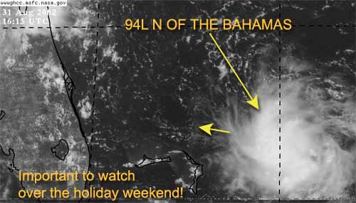
It is Labor Day weekend and the tropics are firing up.
The system (94L) just east-northeast of the northern Bahamas is looking more interesting by the hour. Since this system is so close the east coast of Florida it needs to be watched by all interests along our coast. This system very likely could be Tropical Depression #5 by the end of today.
There is a possibility that it could just die out (although I doubt it). The National Hurricane Center is sending recon out this afternoon to check it out.
In any case, it could bring a lot of rain to Florida for Labor Day. We are definitely keeping a close eye on this one.
Dolly seems to be holding its own at this time (barely) and it continues on its west northwest track. It has the potential of encountering some more heavy shear in the future and may dip below Tropical storm Strength for a while. However, I don't see it dissapating.

NRL Monterey Marine Meteorology Division Forecast Track of Active Systems (Good Forecast Track Graphic and Satellite Photos)
NASA GHCC Interactive Satellite images at:
North Atlantic Visible (Daytime Only), Infrared, Water Vapor
Some forecast models:
NGM, AVN, MRF, ETA ECMWF
DoD Weather Models (NOGAPS, AVN, MRF)
AVN, ECMWF, GFDL, MM5, NOGAPS, UKMET
Other commentary at Mike Anderson's East Coast Triopical Weather Center, Accuweather's Joe Bastardi, Hurricane City, Gary Gray's Millennium Weather, Barometer Bob's Hurricane Hollow, Snonut, Ed Dunham and Jason M in our Storm Forum Even more on the links page.
- [john@flhurricane.com]