CFHC
|
| () |
| Sun Sep 01 2002 11:22 AM |

|
|
|
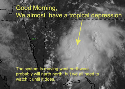
Aircraft Recon is out, at the storm is on the verge of becoming a depression. I would not be surprised later to see tropical storm watches up for our coast fairly soon...
It is 150 miles East of Cape Canaveral right now.
Enjoy the weekend, but continue to check up on this system... Florida and Georiga especially.
Melbourne Radar - Long Range
Dolly still is moving wwn, and barely holding onto tropical storm strenght. I believe it'll pass well north of the caribbean. The Northeast gulf is too disorganized, and western Caribbean isn't looking well.
NRL Monterey Marine Meteorology Division Forecast Track of Active Systems (Good Forecast Track Graphic and Satellite Photos)
NASA GHCC Interactive Satellite images at:
North Atlantic Visible (Daytime Only), Infrared, Water Vapor
Some forecast models:
NGM, AVN, MRF, ETA ECMWF
DoD Weather Models (NOGAPS, AVN, MRF)
AVN, ECMWF, GFDL, MM5, NOGAPS, UKMET
Other commentary at Mike Anderson's East Coast Triopical Weather Center, Accuweather's Joe Bastardi, Hurricane City, Gary Gray's Millennium Weather, Barometer Bob's Hurricane Hollow, Snonut, Ed Dunham and Jason M in our Storm Forum Even more on the links page.
- [mike@flhurricane.com]