CFHC
|
| () |
| Mon Sep 02 2002 05:54 PM |

|
|
|
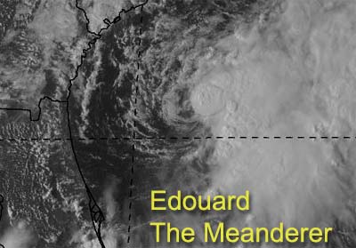
Edouard is going to aggrivate us all most of this week while it just meanders willy nilly around our coasts.
Models suggest that it will do a cyclonic loop and head soutwest into North Florida or Georgia. However this won't be for a while. The good news is that there is shear there, and will keep strengthening of the system in check. But the proximity will cause it to remain a concern even in Central Florida for a while. In fact, the tropical storm watch still remains in effect north of Titusville into South Carolina.
The North Central Gulf, right now, is not favorible for development, but soon this may change as well. I don't think much will come of that one personally, but again proximity to land makes us keep watch on it.
Melbourne Radar - Long Range
Jacksonville Radar - Long Range
Dolly still is a fish spinner.
NRL Monterey Marine Meteorology Division Forecast Track of Active Systems (Good Forecast Track Graphic and Satellite Photos)
NASA GHCC Interactive Satellite images at:
North Atlantic Visible (Daytime Only), Infrared, Water Vapor
Some forecast models:
NGM, AVN, MRF, ETA ECMWF
DoD Weather Models (NOGAPS, AVN, MRF)
AVN, ECMWF, GFDL, MM5, NOGAPS, UKMET
Other commentary at Mike Anderson's East Coast Triopical Weather Center, Accuweather's Joe Bastardi, Hurricane City, Gary Gray's Millennium Weather, Barometer Bob's Hurricane Hollow, Snonut, Ed Dunham and Jason M in our Storm Forum Even more on the links page.
- [mike@flhurricane.com]