CFHC
|
| () |
| Wed Sep 04 2002 08:34 AM |

|
|
|
This will be updated during the day as more information on Edouard is made available.
Noon Update
Minimal Tropical Storm Edouard has been drifting west southwest over the past couple of hours, however, high pressure aloft over the eastern Gulf has been building eastward during the night and should change the movement of Edouard to a more southwesterly direction.
This will place the center of the storm north of the Cape near Daytona Beach later this evening.
Some additional intensification is likely before landfall, so Edouard should retain its Tropical Storm status.
The Position at 11am was near 30Nand 80W.
Most of the rain and stronger wind associated with this system are located to the east and south of the center, and northwesterly upper level wind shear continues to disrupt the cyclone. Late this evening into Thursday, west to northwest winds will approach tropical storm force along the coast.
Squalls with heavy downpours are likely to start as early as this afternoon, becoming more frequent tonight and Thursday along the central and north Florida coast. The National Hurricane Center has issued a Tropical Storm Warning from Titusville northward along the Florida coast and a Tropical Storm Watch from Titusville southward to Sebastian Inlet.
The storm in the northern gulf is coming together, but the situation with Edouard and the rest makes any real forecasting a nightmare still for a bit longer.
Noon update special thanks to Ed Dunham.
8:30 AM Update
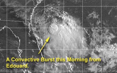
Edouard weakened quite a bit yesterday and much of the convection was sheared off to the east, but this morning it appears that it may be refiring a bit. I think it'll maintain itself as a tropical storm for a while longer. Rain from the storm is being felt along the coastal edge of Volusia now. But the storm itself is still offshore about 80 miles slowly moving. The last public advisory from the NHC stated the windspeed at 40MPH, but new Aircraft Recon reports that occured after the advisory now show it at 50MPH.
The fact that it is over extremely warm water has kept the system from outright dying because of the massive amount of shear it has been receiving. This storm is a survivor, any chance to strengthen it can get, it will take. However, there will not be that many chances for it io do so. I expect it to weaken again later in the day... but maintain itself as a tropical storm.
If the official track holds it'll reach the coast in the overnight hours tonight, and the rain will occur mostly on the eastern side of the system. (This all could change however....) Plenty of folks around the St. Johns really don't need the rain.
Updates will occur today here as needed.
Outside of Edouard, the system in the east atlantic is getting some shear that will keep its developmental possibilities in check for a while (although there is a wave over africa now that may slide out fairly strong later).
Also the Northern gulf is active, but still nothing at the surface. This is one to watch as well, but it still will take a while. Once this does get going, however...
NRL Monterey Marine Meteorology Division Forecast Track of Active Systems (Good Forecast Track Graphic and Satellite Photos)
NASA GHCC Interactive Satellite images at:
North Atlantic Visible (Daytime Only), Infrared, Water Vapor
Some forecast models:
NGM, AVN, MRF, ETA ECMWF
DoD Weather Models (NOGAPS, AVN, MRF)
AVN, ECMWF, GFDL, MM5, NOGAPS, UKMET
Other commentary at Mike Anderson's East Coast Tropical Weather Center, Accuweather's Joe Bastardi, Hurricane City, Gary Gray's Millennium Weather, Barometer Bob's Hurricane Hollow, Snonut, Ed Dunham and Jason M in our Storm Forum Even more on the links page.
- [mike@flhurricane.com]