CFHC
|
| () |
| Fri Sep 13 2002 05:18 AM |

|
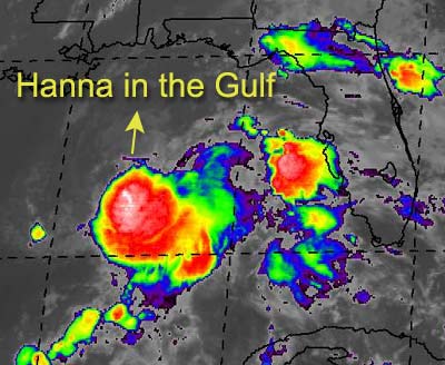
 Tropical Storm Hanna Form in the Gulf
|
Expected to be no more than a Tropical Storm, Hanna forms from Tropical Depression Nine in the Gulf.
Approximately 250 south of Pensacola, it's moving erratically, generally expected to turn to the north. A good rain event for the Pensacola in the panhandle and possible Alabama as well. The exact strength or landfall track is up for grabs.
A system east of the Caribbean in the Atlantic is another potential for the next depression. We're watching that also.
Apologies for lack of updates this week. It's been unavoidable.
NRL Monterey Marine Meteorology Division Forecast Track of Active Systems (Good Forecast Track Graphic and Satellite Photos)
NASA GHCC Interactive Satellite images at:
North Atlantic Visible (Daytime Only), Infrared, Water Vapor
Some forecast models:
NGM, AVN, MRF, ETA ECMWF
DoD Weather Models (NOGAPS, AVN, MRF)
AVN, ECMWF, GFDL, MM5, NOGAPS, UKMET
Other commentary at Mike Anderson's East Coast Tropical Weather Center, Accuweather's Joe Bastardi, Hurricane City, Gary Gray's Millennium Weather, Barometer Bob's Hurricane Hollow, Snonut, Ed Dunham and Jason M in our Storm Forum Even more on the links page.
- [mac]