CFHC
|
| () |
| Sat Sep 14 2002 09:26 PM |

|
|
|
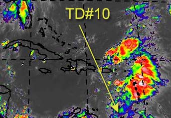
As Hannah makes landfall as a weak tropical storm (but with lots of rain), Tropical Depression Ten forms in the very Southeastern Caribbean.
We may have to watch this one toward the end of the week (Friday or so) as it may near us in Florida. If it survives nipping South America it'll enter into a fairly favorable area to develop and move across the caribbean and eventually into the Atlantic. Lots could happen between now and then, but it's a fairly interesting system as for possibilities. It could even slide into the gulf. In fact the latest GFDL shows this, but right now it could go either way. If it survives the initial bump, I think we may have our first candidate to try to make a run for major hurricane status for the season. Let's hope not.
All eyes may want to be on this during the week, and we'll be tracking it.
Caribbean Hurricane Page - includes reports from individuals scattered across the Caribbean islands
NRL Monterey Marine Meteorology Division Forecast Track of Active Systems (Good Forecast Track Graphic and Satellite Photos)
NASA GHCC Interactive Satellite images at:
North Atlantic Visible (Daytime Only), Infrared, Water Vapor
Some forecast models:
NGM, AVN, MRF, ETA ECMWF
DoD Weather Models (NOGAPS, AVN, MRF)
AVN, ECMWF, GFDL, MM5, NOGAPS, UKMET
Other commentary at Mike Anderson's East Coast Tropical Weather Center, Accuweather's Joe Bastardi, Hurricane City, Gary Gray's Millennium Weather, Barometer Bob's Hurricane Hollow, Snonut, Ed Dunham and Jason M in our Storm Forum Even more on the links page.
- [mike@flhurricane.com]