CFHC
|
| () |
| Tue Sep 17 2002 05:51 PM |

|
|
|
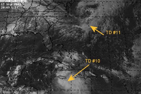
Tropical Depression #11 forms east of Bermuda and is heading to the North at 8mph. Most likely this system will not strengthen too much and become an extratropical fish spinner.
Tropical Depression #10 is a different story. Ten is keeping everyone on edge with its unknown path and strengthening potential. Ten is moving toward the west-northwest near 6mph and a motion to the west-northwest or northwest is expected during the next 24 hours. Also ten is expected to become a tropical storm within the next 24 hours
NRL Monterey Marine Meteorology Division Forecast Track of Active Systems (Good Forecast Track Graphic and Satellite Photos)
NASA GHCC Interactive Satellite images at:
North Atlantic Visible (Daytime Only), Infrared, Water Vapor
Some forecast models:
NGM, AVN, MRF, ETA ECMWF
DoD Weather Models (NOGAPS, AVN, MRF)
AVN, ECMWF, GFDL, MM5, NOGAPS, UKMET
Other commentary at Mike Anderson's East Coast Tropical Weather Center, Accuweather's Joe Bastardi, Hurricane City, Gary Gray's Millennium Weather, Barometer Bob's Hurricane Hollow, Snonut, Ed Dunham and Jason M in our Storm Forum Even more on the links page.
- [john@flhurricane.com]