MikeC
|
| (Admin) |
| Sat Sep 21 2002 05:20 PM |
|
|
6PM Update
Isidore... Recon found pressure down to 945mb, Eyewall is reforming and is half open on the western side.
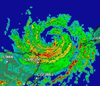
Radar from Cancun
Originial Update
The tropics have come alive.
We have the wanderer Isidore, still crawling in the Southeast gulf, still unsure on it's future, nearing Category 4 status. Kyle, meandering around in the middle of the Atlantic, and TD#13 that just formed that will be threatening the Eastern Caribbean islands.

The big question... Do we know any more on Isidore? The answer is no, the northerly turn is still a possiblity, but right now there is no real movement. West, sorta, maybe north a bit, maybe south a bit, kinda. It's wobbling right now (northwest from what I saw), and we'll have to watch the trends. Nothing new on this so far. Continue to keep watch.
Tons of rain is still occuring on Jamaica and western Cuba, amazing amounts in fact.
Jim Williams (Hurricane City) and Barometer bob are doing live Audio shows starting at 8PM and lasting usually to 10 or 11PM all during Isidore's run. Use the link below to check them out.
Cancun, Mexico Radar
NRL Monterey Marine Meteorology Division Forecast Track of Active Systems (Good Forecast Track Graphic and Satellite Photos)
NASA GHCC Interactive Satellite images at:
North Atlantic Visible (Daytime Only), Infrared, Water Vapor
Some forecast models:
NGM, AVN, MRF, ETA ECMWF
DoD Weather Models (NOGAPS, AVN, MRF)
AVN, ECMWF, GFDL, MM5, NOGAPS, UKMET
Other commentary at Mike Anderson's East Coast Tropical Weather Center, Robert Lightbown/Crown Weather Tropical Update Accuweather's Joe Bastardi, Hurricane City Weather Audio Broadcast Network - Live Audio from Jim Williams and Barometer Bob , Tropical Weather Watchers.Com (JasonM) Gary Gray's Millennium Weather, Barometer Bob's Hurricane Hollow, Snonut, Ed Dunham and Jason M in our Storm Forum Even more on the links page.
- [mike@flhurricane.com]