MikeC
|
| (Admin) |
| Tue Oct 15 2002 09:54 AM |
|
|
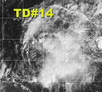
Tropical Depression 14 is still in the Caribbean moving toward the Caymans, it will have a little bit of opportunity to strengthen, but not much. I think it will become marko, but avoid "landfall" on Florida and move over the bahamas as a minimal tropical storm. it then will race off to the Northeast to make way for the front that will finally cool us down here.
Hurricane Season isn't quite over, but the bulk of it was around the time of Isidore, Kile, and Lili. Things will be quieter here from now on. If another storm does develop we will post for sure. Keep watching, when you take your eye off is when the storm may approach.
NRL Monterey Marine Meteorology Division Forecast Track of Active Systems (Good Forecast Track Graphic and Satellite Photos)
NASA GHCC Interactive Satellite images at:
North Atlantic Visible (Daytime Only), Infrared, Water Vapor
Some forecast models:
NGM, AVN, MRF, ETA ECMWF
DoD Weather Models (NOGAPS, AVN, MRF)
AVN, ECMWF, GFDL, MM5, NOGAPS, UKMET
Multi-model plots from WREL
Other commentary at Mike Anderson's East Coast Tropical Weather Center, Robert Lightbown/Crown Weather Tropical Update Accuweather's Joe Bastardi, Hurricane City Weather Audio Broadcast Network - Live Audio from Jim Williams and Barometer Bob , mpittweather , Tropical Weather Watchers.Com (JasonM) Gary Gray's Millennium Weather, Barometer Bob's Hurricane Hollow, Snonut, Ed Dunham and Jason M in our Storm Forum Even more on the links page.
- [mac]