CFHC
|
| () |
| Wed Jun 05 2002 04:40 PM |

|
|
|
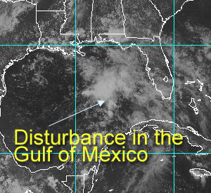
A system...
In the Gulf. Since June 2nd, the tropical weather outlook has mentioned this system in the Gulf, and today, well it still looks as if it won't do much. However, for the time of year it has a fair shot for development.
There are plenty of reasons for it NOT to develop into anything. Definitely not named storm material, but the potential is there to make rain. There will be other opportunities for wave mongering in June. I still don't expect anything to happen until late July. And I'm with Dr. William Gray on the predictions for number of storms.
As to where they will hit. I'm going to say lowest chances are here and the Northeast. Biggest chance is south florida, and the texas coast this year. Middle of the road chances are the central Gulf Coast and the carolinas. Note, this means absolutely nothing!
On my development scale, where is this system?
code: forget it) 0 1 2 3 4 5 6 7 8 9 10 (sure thing)

           [---*------------------]
If it develops, it won't be beyond a depression, and I doubt it'll get that far. It's basically something early to look at to get us warmed up.
Our system for the new CFHC is still unfinished, but this i a byproduct of being caught up too much in my day job
NASA GHCC Interactive Satellite images at:
North Atlantic Visible (Daytime Only), Infrared, Water Vapor
Some forecast models:
NGM, AVN, MRF, ETA ECMWF
DoD Weather Models (NOGAPS, AVN, MRF)
AVN, ECMWF, GFDL, MM5, NOGAPS, UKMET
Other commentary at Mike Anderson's East Coast Triopical Weather Center, Accuweather's Joe Bastardi, Hurricane City, Gary Gray's Millennium Weather, Even more on the links page.
- [mac]