MikeC
|
| (Admin) |
| Thu Jul 08 2004 12:16 PM |
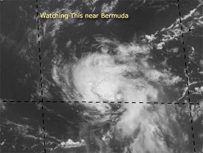
 Watching Activity Near Bermuda
|
Currently we are watching a system southeast of Bermuda to possibly be the first depression of the season.
It's moving Northeastward, so it won't be affecting land. But it's starting to form a low level circulation, so there is a good chance we'll see a depression this evening or tomorrow.
In the Atlantic between Africa and the Caribbean, there's another wave, but it's fairly disorganized at the moment.
NRL Monterey Marine Meteorology Division Forecast Track of Active Systems (Good Forecast Track Graphic and Satellite Photos) (Backup site)
Follow worldwide SST evolution here:
Global SST Animation
NASA GHCC Interactive Satellite images at:
North Atlantic Visible (Daytime Only), Infrared, Water Vapor
Some forecast models:
NGM, AVN, MRF, ETA ECMWF
DoD Weather Models (NOGAPS, AVN, MRF)
AVN, ECMWF, GFDL, MM5, NOGAPS, UKMET
Multi-model plots from WREL
Other commentary at Mike Anderson's East Coast Tropical Weather Center, Robert Lightbown/Crown Weather Tropical Update Accuweather's Joe Bastardi (now subcriber only unfortunately), Cyclomax (Rich B.), Hurricane City , mpittweather , Tropical Weather Watchers.Com (JasonM) Gary Gray's Millennium Weather, Barometer Bob's Hurricane Hollow, Snonut,
Even more on the links page.