MikeC
|
| (Admin) |
| Mon Jul 19 2004 01:41 PM |
|
|
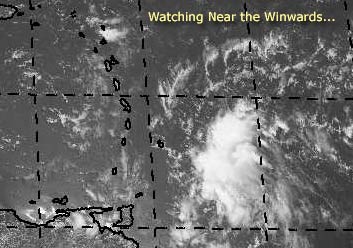
There's a system that could develop east of the Winwards. I'm not too sure it will last if it does though, the environment ahead of it isn't too great to be sustaining a system.
We'll be watching it though.
Mike's Tropical Development Probability Scale
Code:
forget it) 0 1 2 3 4 5 6 7 8 9 10 (sure thing)

          [-----*----------------]
It hasn't reached invest status yet, but we are watching.
Event Related Links
Martinique Radar
The Caribbean Hurricane Page - updates from the islands
Caribbean Island Weather Reports
General Links
NRL Monterey Marine Meteorology Division Forecast Track of Active Systems (Good Forecast Track Graphic and Satellite Photos)
Check the Storm Forum from time to time for comments on any new developing system.
Follow worldwide SST evolution here:
Global SST Animation
NASA GHCC Interactive Satellite images at:
North Atlantic Visible (Daytime Only), Infrared, Water Vapor
Some forecast models:
NGM, AVN, MRF, ETA ECMWF
DoD Weather Models (NOGAPS, AVN, MRF)
AVN, ECMWF, GFDL, MM5, NOGAPS, UKMET
Multi-model plots from WREL
Other commentary at Mike Anderson's East Coast Tropical Weather Center, Independentwx.com, Robert Lightbown/Crown Weather Tropical Update Accuweather's Joe Bastardi (now subcriber only unfortunately), Cyclomax (Rich B.), Hurricane City , mpittweather , Tropical Weather Watchers.Com (JasonM) Gary Gray's Millennium Weather, Barometer Bob's Hurricane Hollow, Snonut,
Even more on the links page.