MikeC
|
| (Admin) |
| Tue Jul 27 2004 09:51 PM |
|
|
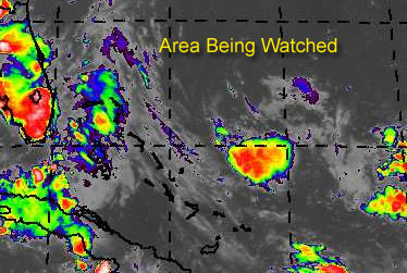
East of the Bahama islands, there is an area of storms... a trough of low pressure. on the surface. Right now upper level winds are keeping any potential development down, but the area looks like it could calm a bit.
There is a chance for development and it could become a depression before Friday.
If it did, and this is important, chances are that it would veer eventually to the northwest and then north and miss the coast of the United States completely. However, as always, this should be watched to see if it continues to show signs of wanting to become a tropical depression.
Develoment Potential scale
Code:
forget it) 0 1 2 3 4 5 6 7 8 9 10 (sure thing)

            [------*---------------]
Since it hasn't reached invest status, and still could fall apart, it'll just be watched at the moment.
General Links
NRL Monterey Marine Meteorology Division Forecast Track of Active Systems (Good Forecast Track Graphic and Satellite Photos)
Check the Storm Forum from time to time for comments on any new developing system.
Follow worldwide SST evolution here:
Global SST Animation
NASA GHCC Interactive Satellite images at:
North Atlantic Visible (Daytime Only), Infrared, Water Vapor
Some forecast models:
NGM, AVN, MRF, ETA ECMWF
DoD Weather Models (NOGAPS, AVN, MRF)
Multi-model plots from WREL
Other commentary at Mike Anderson's East Coast Tropical Weather Center, Independentwx.com, Robert Lightbown/Crown Weather Tropical Update Accuweather's Joe Bastardi (now subcriber only unfortunately), Cyclomax (Rich B.), Hurricane City , mpittweather , Tropical Weather Watchers.Com (JasonM) Gary Gray's Millennium Weather, Barometer Bob's Hurricane Hollow, Snonut,
Even more on the links page.