MikeC
|
| (Admin) |
| Mon Aug 02 2004 08:55 AM |
|
|
5PM Update - Hurricane Warnings Up
Hurricane Warnings up now from Cape Lookout to Oregon Inlet, NC
Tropical Storm Warnings up for north of Oregon Inlet to the North Carolina-Virginia state border.
Wilmington, NC Long Range Radar Loop
4PM Update
Alex is holding its own and may fluctuate a bit in strength. As usual I'm looking for reasons it won't hit land, and I'm finding a lot. It's going to be very close, but most likely won't ever make landfall. And the winds are weakest in the NW quad. So even though it could possibly change and we should watch it, I don't expect much land effects from the storm. (Although some places will get rain and nasty squalls from the storm)
Out in the east Atlantic a few systems are getting interesting and we may have another storm to track. And those (91L specifically) may come close to the Caribbean islands later. (Although I suspect they mav jog north of the islands.) Time to watch those as we carefully watch Alex and its trends.
The other in the far eastern Atlantic (92L) is a good candidate for a fish spinner. But we'll watch.
Original Update
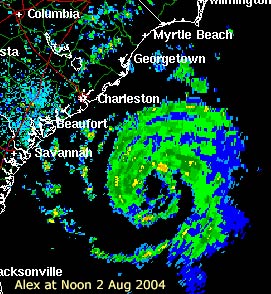
Alex at noon today. (link is Charleston Long Range Radar)
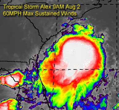
A special 8PM advisory suite came out of the National Hurricane Center at 8AM this morning strengthening, somewhat drastically from the previous advisory, the top windspeed to 60MPH. Which is approaching a strong tropical storm.
Because of the situation around Alex, it may come close to hurricane strength. However, it's not expected to make landfall, but meander along the coastline slowly.
Folks along the coast there will need to watch this one extremely closely for any more surprises.
Also, the gulf system lost tis chance to develop, nothing will occur with the former 90L system. But in the eastern Atlantic, we might find our next depression within a few days.
Event Related Links
*BEST BET*Wilmington, NC Long Range Radar Loop
Charleston, SC Radar Loop
Charleston, SC Long Range Radar
Jacksonville, FL Long Range Radar
General Links
Current Aircraft Recon Info
NRL Monterey Marine Meteorology Division Forecast Track of Active Systems (Good Forecast Track Graphic and Satellite Photos)
Check the Storm Forum from time to time for comments on any new developing system.
Follow worldwide SST evolution here:
Global SST Animation
NASA GHCC Interactive Satellite images at:
North Atlantic Visible (Daytime Only), Infrared, Water Vapor
Some forecast models:
NGM, AVN, MRF, ETA ECMWF
AVN, CMC, GFDL, JMA, NOGAPS, UKMET
DoD Weather Models (NOGAPS, AVN, MRF)
Multi-model plots from WREL
Other commentary at Independentwx.com, Robert Lightbown/Crown Weather Tropical Update Accuweather's Joe Bastardi (now subcriber only unfortunately), Hurricane Alley North Atlantic Page, Cyclomax (Rich B.), Hurricane City , mpittweather , Gary Gray's Millennium Weather, storm2k, Barometer Bob's Hurricane Hollow, Snonut,
Even more on the links page.