MikeC
|
| (Admin) |
| Tue Aug 03 2004 07:41 AM |
|
|
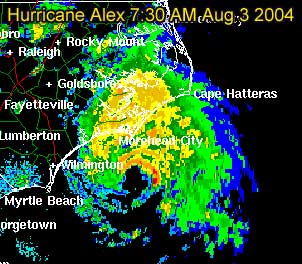
8AM
Windspeed increased to 90MPH. Pressure dropping. Still looks like it will skirt the coastline and never truly make landfall, but it's splitting hairs at that level.
Original Update:
Alex overnight has become this year's first Hurricane of the season, with maximum sustained winds as of 5AM at 80MPH.
It's current movement to the northeast this morning puts it very close to the North Carolina coastline, but looks like the eye will not make landfall. It's currently moving nearly parallel to the coastline. One caveat, a slight jog to the left could put it over briefly. And it's close enough to the outer banks for it to feel quite a bit of this storm.
Wilmington, NC Long Range Radar Loop
Morehead City, NC Long Range Radar Loop
Norfolk/Wakefield, VA Long Range Radar Loop
Best of luck to to folks in North Carolina, as a good chunk of the rain shield is over the coastline now. And I suspect a few parts of the outer banks will get hurricane force winds, even if the eyewall doesn't pass over. We'll be watching all day.
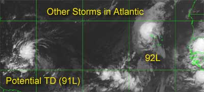
The other storms in the Atlantic still have the potential to form, and folks in the eastern Caribbean (lesser antilles) will want to watch, because it has a chance to strengthen and get close.
More updates to come during the day....
Event Related Links
*BEST BET*Wilmington, NC Long Range Radar Loop
Morehead City, NC Long Range Radar Loop
Norfolk/Wakefield, VA Long Range Radar Loop
Charleston, SC Radar Loop
Charleston, SC Long Range Radar
Jacksonville, FL Long Range Radar
North Carolina Weather Reports
General Links
Current Aircraft Recon Info
NRL Monterey Marine Meteorology Division Forecast Track of Active Systems (Good Forecast Track Graphic and Satellite Photos)
Check the Storm Forum from time to time for comments on any new developing system.
Follow worldwide SST evolution here:
Global SST Animation
NASA GHCC Interactive Satellite images at:
North Atlantic Visible (Daytime Only), Infrared, Water Vapor
LSU Sat images
Some forecast models:
NGM, AVN, MRF, ETA ECMWF
AVN, CMC, GFDL, JMA, NOGAPS, UKMET
DoD Weather Models (NOGAPS, AVN, MRF)
Multi-model plots from WREL
Other commentary at Independentwx.com, Robert Lightbown/Crown Weather Tropical Update Accuweather's Joe Bastardi (now subcriber only unfortunately), Hurricane Alley North Atlantic Page, Cyclomax (Rich B.), Hurricane City , mpittweather , Gary Gray's Millennium Weather, storm2k, Barometer Bob's Hurricane Hollow, Snonut,
Even more on the links page.