MikeC
|
| (Admin) |
| Tue Aug 03 2004 10:49 AM |
|
|
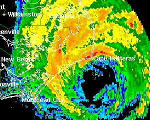
2PM EDT Update - Hurricane Alex:
Radar shows the eyewall over the Outer Banks of North Carolina as Hurricane Alex continues toward the northeast and out to sea at 17mph. Central pressure has been reported as low as 970mb by the Hurricane Hunters. A few locations in the Outer Banks have reported wind gusts in excess of 80mph.
ED
Original Post:
Hurricane Alex still is encroaching dangerously close to the outer banks and Cape Hatteras. At 11AM it has a maximum sustained windspeed of 100MPH and now is a category 2 storm.
and...
Tropical Depression #2 has formed east of the lesser Antilles. Moving generally westward. It is forecast to become a hurricane in a few days, and watches may be up for the LesserAntilles as early as this afternoon. It's a fairly fast mover right now.
More to come...
Event Related Links
*BEST BET*Wilmington, NC Long Range Radar Loop
Morehead City, NC Long Range Radar Loop
Norfolk/Wakefield, VA Long Range Radar Loop
Charleston, SC Radar Loop
Charleston, SC Long Range Radar
Jacksonville, FL Long Range Radar
North Carolina Weather Reports
General Links
Current Aircraft Recon Info
NRL Monterey Marine Meteorology Division Forecast Track of Active Systems (Good Forecast Track Graphic and Satellite Photos)
Check the Storm Forum from time to time for comments on any new developing system.
Follow worldwide SST evolution here:
Global SST Animation
NASA GHCC Interactive Satellite images at:
North Atlantic Visible (Daytime Only), Infrared, Water Vapor
LSU Sat images
Some forecast models:
NGM, AVN, MRF, ETA ECMWF
AVN, CMC, GFDL, JMA, NOGAPS, UKMET
DoD Weather Models (NOGAPS, AVN, MRF)
Multi-model plots from WREL
Other commentary at Independentwx.com, Robert Lightbown/Crown Weather Tropical Update Accuweather's Joe Bastardi (now subcriber only unfortunately), Hurricane Alley North Atlantic Page, Cyclomax (Rich B.), Hurricane City , mpittweather , Gary Gray's Millennium Weather, storm2k, Barometer Bob's Hurricane Hollow, Snonut,
Even more on the links page.