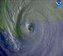
It's obviously way to early to try to pinpoint a landfalling position. The dubious thing is that this will make a US mainland landfall. There is no escaping that at this point. The ridge will certainly be strong enough to bring the storm to east coast if not across Florida and into the Gulf. It's really amazing to me, even after all these years studying canes and meteorology in general, how in awe of these things I am. Frances is just an amazing storm already, and she hasn't even hit 50W. The "buzz-saw" look to it just reminds me so much of Andrew and it's obviously taking a somewhat similar track (generalization, i.e. the upcoming bend back to the west) as its 1992 counterpart. It's looks like it's going to be bad news for someone.
|
