MikeC
|
| (Admin) |
| Sat Jul 16 2005 09:47 AM |
|
|
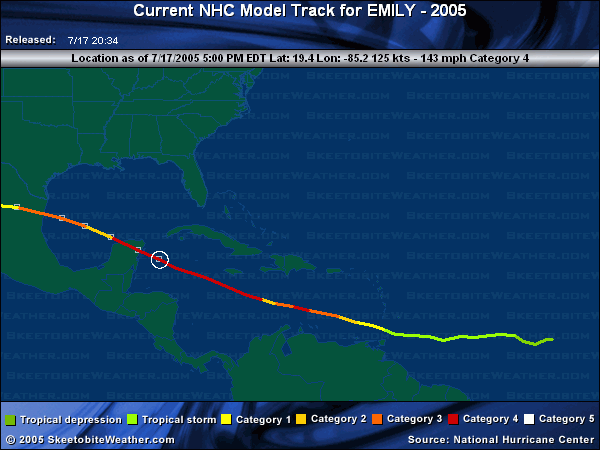
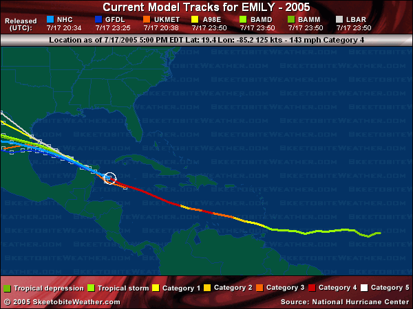
6PM 17.July Update
Emily is nearing the Yucatan this evening, and the eye is viewable on the Cancun radar. The eye was looking ragged earlier, but it looks like its reforming now.
Future track for a second landfall is still into Mexico, with southern Texas still inside the cone.
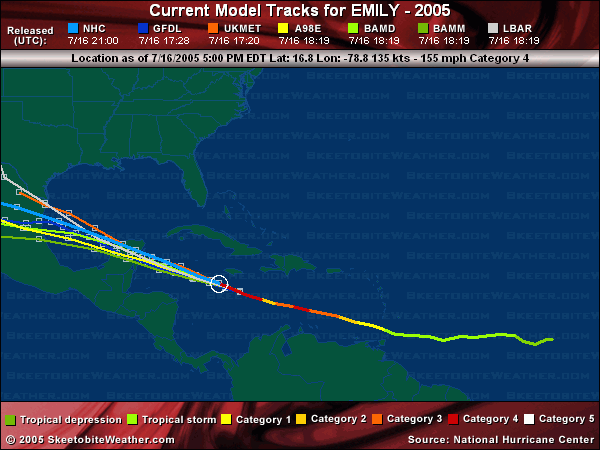
11AM 17.July Update
Emily is holding as a strong Category 4 storm, with a relatively small eye. Warnings are up for the Yucatan, and landfall will likely be overnight.
Since it is small it is likely to be weakened considerably by the yucatan so when it re-emerges in the Gulf it will still be a hurricane, but a much weaker one. And depending on how much the storm degrades, it may have a chance to become a major again for a second landfall most likely in Mexico near Tampico.

6PM Update
Hurricane Emily is now a high end Category 4 storm, 1 MPH shy away from Category 5 status. It is possible for it to become a Category 5 briefly still. It is still moving toward the Yucatan, and will likely be category 3 or 4 when it makes landfall along the eastern coast.

It will weaken some over land, and then emerge into the Bay of Camphece. A second landfall is Mexico beyond that is the most likely scenario. Folks up into southern texas will want to watch it as well.
99L is turning out to sea, leaving not much else currently in the tropics after Emily, which will be a welcome break.
Original Update
Hurricane Emily continues to Deepen in the Caribbean, now a category 4 storm, and has a chance at category 5, although if it does I doubt it will hold that extreme very long.

Emily is passing south of Jamaica, and the Caymans, but close enough that the Caymans will see strong winds, maybe as high as category 1 strength. Before it has moved on The Yucatan will have to deal with this directly later, and Hurricane watches will likely be up for parts of it later today.
Beyond that, and after it crosses the Yucatan. (Which should knock a lot of the intensity out of ti) it still looks like a Mexico hit or possibly Texas. The more likely of the two is into Mexico..
Event Related Links
StormCarib hurricane reports from observers in the Islands
Caribbean Island Weather Reports
Color Sat of Gulf (Animated)
RAMSDIS high speed visible Floater of Storms
Emily
Flhurricane mirror of cancun radar - Cancun Radar Loop Cancun, MX radar (Overloaded please use mirrors)
Tampico, MX radar
Visible/IR Floater of Emily with storm track Overlays
Animated Model Plot of Emily
Model Plot Graphic from the South Florida Water Management District of Emily
Emily Spaghetti Model from boatus
Weather Underground Model Plots for Emily
QuikScat Image of Emily
Dennis and emily plotted on a google map
Webcams, Video, Audio
Jim Edds/weathervine chasing hurricane Emily in Cancun
Cancun Webcams
Cozumel Webcams
Hurricane City's audio feed, show starts at 11PM EDT
Radio NHCWX
Area east of Emily (99L)
Animated Model Plot of Area East of Emily 99L
Model Plot of Area East of Emily 99L (Graphic from the South Florida Water Management District)