MikeC
|
| (Admin) |
| Wed Aug 10 2005 06:25 PM |
|
|
8AM 11.Aug.2005
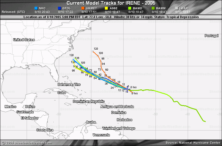
Irene is struggling due to a lot of dry air out in front of it, but maintaining itself. It may strengthen, very slowly, or not much at all today because of the dry air.

The most likely scenario stilll is that Irene will recurve out to sea before approaching land, however anyone in the cone should be watching it. Judging by current trends it should past just east of the Carolina and then recurve out. If it slides further west it would touch the outher banks.

For Florida, the only possible affect I can see with this track is maybe a slight reduction in the amount of afternoon thunderstorms as the storm moves west. (Irene needs all the moisture it can get in the current environment it has). Chances for anything more than that are too low to really mention.
Bottom line, if you are in the Cone area, keep watching it closely. The timing of the move to the north is everything once again. Dry air will keep it from strengthening until it reaches 70W or so.
11PM
Irene is once again a tropical storm, but barely. The track was adjusted to the north somewhat tonight, and I'm seeing some hope that a weakness in the ridge is developing, keeping Floirda out of the cone, and giving the out to sea scenario a boost. However, anywhere in the cone should be watching the system. Especially North Carolina.
It all depends on how the ridge holds up or not. I'm still leaning toward... or perhaps hoping.. for the out to sea scenario, but very close to the Carolinas.
Original Update
Tropical Depression Irene has remained weak, and I'm beginning to think it will stay weak as a depression or a minimal to mid-strength tropical storm for the next few days.
Dry air will also keep it in check from gaining strength too rapidly. The center still remains difficult to pinpoint.

Irene's future track depends a lot on the ridge and any situation which might weaken it, and cause it to move more northward. Today it's moving a little more toward the north than it was yesterday, which is good news for Florida, and more interesting for the Carolinas. The potential to move out to sea is still possible and remains the most likely, but even if so it may still make a close approach to the Carolinas.
Alternatively the ridge builds even more and forces it further west, probably keeping the storm weaker a bit longer. This increases the chances for a bit further south. It's likely Florida will enter into the Cone of error tomorrow for the 5 day period, but the highest probability will remain for the Carolinas.
Models have been a bit right (or north) biased the last two or three days or so, I expect more of a westward trend, which will force everyone to watch the system. Assuming Irene can survive and the ridging builds, we will probably know better in about 2-3 days.
Bottom line, it needs to be watched, especially for the Carolinas.
There are a few more waves over Africa that will require a long term eye soon as well.
Event Related Links
StormCarib hurricane reports from observers in the Islands
Caribbean Island Weather Reports
Color Sat of Gulf
RAMSDIS high speed visible Floater of Storms
Irene
Animated Model Plot of Irene
Satellite Image of Irene with Storm Track Overlays
Infrared color Satellite Image of Irene with Storm track Overlays
Model Plot of Irene (Graphic from the South Florida Water Management District)
Quikscat image of Irene
Weather Underground model plots of Irene
Irene Sphagetti Plot from BoatUS