MikeC
|
| (Admin) |
| Sat Aug 18 2007 03:06 PM |
|
|
11 PM EDT 18 August Update
Dean has weakened in windspeed, but lowered in pressure, so Dean is reorganizing itself. And windspeed should catch up by it tomorrow. There is a very good chance that Dean will be a category 5 system as it approaches Jamaica.
The track has actually gone further left (or west) than previously thought, and the Official Forecast takes it along the Southern part of Jamaica. The windfield is very large with the storm. Jamaica will start seeing the first of Dean overnight, with the eye reaching the island in about 18 hours.

5PM EDT 18 August Update
Dean's forecast remains about the same as before, if not a little southward. Those in the cone of error, especially further out should still watch it. Those north of the cone should be aware and keep up with Dean is doing, but chances are falling that something would happen there.

Intensity is held at the same level, but it appears that it's finishing up it's first eyewall replacement cycle and may get another run of intensification tonight. There are a few other factors (like hati) that may keep it from gaining too much, but it has plenty going for it.
Jamaica, be strong.
3PM EDT 18 August Update
Dean is undergoing an eyewall replacement cycle now, with double (perhaps triple) eyewalls as it reorganizes itself, this unfortunately gives it time to recover from it by the time it gets to Jamaica. The land interaction with Hati may also slow reorganization, or even help to weaken it a bit, but it won't have too great an affect on the system.

The forecast track from 11 seems dead on, and there is no current reason to doubt the track, bad news for Jamaica. The official forecast takes the center of Hurricane Dean directly over Kingston Jamaica and through the entire island.
Beyond that, it appears that the Mexcian landfall is the most probable (Perhaps a clip of the Yucatan), followed by a south Texas hit. Other areas in the gulf have very little chance of seeing something from Dean at this time.
Do you have your own take on what Dean will do? Let us know here.
Discuss preparation, damage reports, and general Island Information here
More to come later, recon aircraft is still flying around in the storm.
Original Update
Hurricane Dean remains a strong Category 4 storm as it moves west northwest through the Caribbean. Hurricane Warnings are up for Jamaica and Hati, and those there should be done preparing, as they will feel the worst of the storm tomorrow.
The future track is fairly consistently moving it slightly north of due west into the Yucatan, however the GFDL still insists on a more northerly track, and the storm has moved slightly more north than expected, so there is still reason to watch this system in the Gulf. This afternoon, night and tomorrow is the critical time for many of these model runs. The GFS and other models have been remarkably consistent ant for days now, moving the storm into Northern Mexico. Northern Mexico is the most likely scenario.

There were initialization problems with the wildcard upper level low over Florida, which along with a high west of it, is probably the single biggest concern with the model tracks right now. We'll be watching it to see how the storm progresses throughout the day, and how the forward speed changes.
Intensity of Dean will fluctuate down and up based on all sorts of things, look for dry air, eyewall replacement cycles, and land interaction to cause weakening, and warmer sea surface temperatures to the west of the system to help it gain more intensity.
More to come soon.
Event Related Links:
Jamaican Media
Jamaican Radio (106 Power)
Go Jamaica Hurricane Dean Watch
Jamaica Gleaner (Jamaican Newspaper)
Jamaica Observer (Newspaper)
Nationwide Radio (Hurricane coverage and live reports
starting evening 8/18.)
Jamaican News/Talk 93
Love 101 Radio
Kool 97 Radio
Irie FM Radio
Other
Jamaican Webcam recording... Treasure Beach
Jim Williams will be doing a live show on Dean tonight at hurricane city (8PM EDT)
Jamaican StormCarib Reports
Jamaican Meteorological Service
{{Radarlink|jua|San Juan, Puerto Rico}}
Guantanamo Bay, Cuba Radar
Southern Cuba Radar (Has Jamaica partially in range
Cuban Radar Mosaic (flhurricane long term recording of this radar)
Martinique Radar Animation Recording
{{StormCarib}}
{{StormLinks|Dean|04|4|2007|1|Hurricane Dean (Far Eastern Atlantic)}}
| dem05 |
| (User) |
| Sat Aug 18 2007 03:24 PM |
| Attachment |
|
|
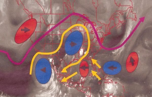
This is a re-post from the previous thread

I’ve attached an image I created that depicts the upper level features over the CONUS and Atlantic Basin. You may want to make a copy to follow along in the discussion. I hope it helps in depicting some of what I am seeing.
I’d also like to repost the Water Vapor Links:
Pacific NW Water Vapor Loop: http://www.goes.noaa.gov/GSSLOOPS/wcwv.html
Atlantic Wide Water Vapor: http://www.ssd.noaa.gov/goes/east/tatl/loop-wv.html
NW Atlantic Water Vapor: http://www.ssd.noaa.gov/goes/east/nwatl/loop-wv.html
CONUS Water Vapor: http://www.goes.noaa.gov/GSSLOOPS/ecwv.html
Well, I have a bag full of wrenches, so I may as well start throwing. Before I do however, I do want to caution that I will not be delving into the models or basing my statements on much of what the models have to say. Traditionally, this is a dangerous game, but with indication that the models are having a tough time in initializing storm intensity, the intensity of the upper level features, and problems with the models racing Dean off probably a bit too fast, I’ve decided not to go much farther in my discussion of them than this. With that said, the models very well may have the correct solution albeit they are not performing as well as one would hope.
The breakdown:
The Florida Upper Level Low is on the move again. From my best estimate, the center is probably right about above my head here in SW FL as I type. It does look like it is now trying to tuck south of the High Pressure Ridge. At some point, I will imagine that the Upper Low will have to either stall or phase out. At this point, it shows no evidence of phasing out, but that may happen in a couple days. Earlier, someone asked about Dean’s forward speed slowdown and how the interaction will affect track. If the Upper Level low had been stationary right now, we would likely expect that Dean would be turning North at some point. However, The Upper Level Low is also moving westward, so I would expect it’s overall influences to resulting a general WNW motion for the next 2-3 days. Dean is probably close enough to feel some of these effects now, but it is also far enough away that I would expect to see subtle fluctuations in forward speed and direction. In other words, Dean slows down a bit, the ULL moves a bit further away, the ridge builds backing a bit and Dean will move slightly faster and a little more westerly…Then Dean will catch up again, slow down and move a bit more WNWerly. In general though, I would not dismiss the Idea that Dean may get closer to Haiti than anticipated. Later on down the road, if the Upper Level low does not phase out and it stalls between 90-95W…I would say that chances for problems in the Eastern Gulf would really increase…Otherwise, the further west it can move before stalling or dissipating will result in problems points west.
Side note/disclaimer: The yellow arrows do not show a forecasted track. They are just there to show the upper air flow ahead of Dean.
Looking at the mid latitude weather systems and the jet stream, there are some other considerations to make. The jet stream over the CONUSis not zonal like it was a few days ago. (The jet stream is identified in the pink, the movement of the jet stream is outlined with Green Arrows). The trough over the Northeast US is moving out and being replaced by a ridge. The ridge is highlighted in Blue and this is the feature that the Florida ULL will sweep under. With that said, the ridge IS moving east, and may continue to do so through this evolution. There is a pretty darn good trough entering the Pacific. This trough is probably starting to move the US weather patterns along. At this time, I know the $64,000 question would be…Will that trough get into the Gulf area. Unfortunately, I don’t have an answer for that or if it would have a direct affect on Dean…But it is something to watch, and I have included a link to the Pacific NW Water Vapor Loop. With that said, it is not impossible to assume that the Florida ULL may stall in a couple days as the High Pressure ridge moves east and the Upper Level Low moves around to the SW Side of the ridge. For an additional quirk that may be another wildcard factor…It does appear that the remnants of Erin may also be evolving into a weak upper level low feature. I really can’t say that this would have any ramifications on the overall upper level pattern, but over time, it will be interesting to see if anything unfolds with that.
So that’s basically the way I see it right now…Unfortunately there are more questions than answers, but it is still to early to Pinpoint specific threats and/or dismiss any Gulf Coast possibilities at this point. Keep on tracking…
| mr jimmy |
| (Registered User) |
| Sat Aug 18 2007 03:44 PM |
|
|
Does anyone have a recent pic or link to one of the magificent closeups of the eye of Dean that shows the internal features? Thanks - I lost my old links yet remember the fascinating shots of the Katrina eye.
| Allison |
| (Weather Guru) |
| Sat Aug 18 2007 04:14 PM |

|
|
|
Quote:
Does anyone have a recent pic or link to one of the magificent closeups of the eye of Dean that shows the internal features? Thanks - I lost my old links yet remember the fascinating shots of the Katrina eye.
Is this the link you're looking for?:
http://www1.cira.colostate.edu/RAMM/Rmsdsol/TROPICAL.html
| pcola |
| (Storm Tracker) |
| Sat Aug 18 2007 04:22 PM |

|
|
|
Anyone looking at the CMC model. I don't have much faith in it but it does show a rather robust tropical system heading towards the east coast of FL later in the week, and another near the lesser antilles.
| RideTheLightning |
| (Registered User) |
| Sat Aug 18 2007 04:25 PM |
|
|
Outstanding observations and excellent information! I agree with your observations. The gulf ULL, and the massive , fast moving pacific trough could have a significant northern shift in the future forecast track. The GFDL model runs have obviously been picking up on this.
| scottsvb |
| (Weather Master) |
| Sat Aug 18 2007 04:25 PM |
|
|
There will be them 2 areas to watch but question on the bahamas and florida 1 will be how strong will it really be. GFS shows a trough or weak TS at best. Might be lacking moisture but we will know by monday night.
| R2RICKSTER |
| (Registered User) |
| Sat Aug 18 2007 04:26 PM |
|
|
Or this
http://www.nnvl.noaa.gov/cgi-bin/index.cgi?page=items&ser=111962
| Random Chaos |
| (Weather Analyst) |
| Sat Aug 18 2007 04:39 PM |

|
|
|
Looks like an ERC coming up:
805
URNT12 KNHC 181636
VORTEX DATA MESSAGE AL042007
A. 18/16:14:30Z
B. 15 deg 46 min N
069 deg 02 min W
C. 700 mb 2488 m
D. 119 kt
E. 018 deg 8 nm
F. 113 deg 128 kt
G. 018 deg 008 nm
H. 930 mb
I. 9 C/ 3050 m
J. 20 C/ 3046 m
K. 11 C/ NA
L. OPEN S
M. C11
N. 12345/7
O. 0.02 / 2 nm
P. AF304 0604A DEAN OB 21
MAX FL WIND 128 KT N QUAD 16:12:00 Z
NORTH EYEWALL HAS DOUBLE EYEWALL STRUCTURE
| Hugh |
| (Senior Storm Chaser) |
| Sat Aug 18 2007 04:40 PM |
|
|
Looking at the latest recon report, it says:
North eyewall has double eyewall structure
Is this the beginning of an eyewall replacement cycle, which would (I think, anyway) explain the weakening satellite presentation over the last several hours?
(oops, Random Chaos beat me to it!)
Assuming this IS an ERC, it could - COULD - mean a weaker Dean in the short term, but an even stronger Dean in the next couple of days, as it approaches Jamaica.
| Random Chaos |
| (Weather Analyst) |
| Sat Aug 18 2007 04:48 PM |
|
|
|
|
We have a good microwave overpass:
http://www.nrlmry.navy.mil/tc_pages/tc07/ATL/04L.DEAN/tmi/tmi_85h/1degreeticks/full/Latest.html
Looks like it is undergoing some structural changes.
| weathernet |
| (Storm Tracker) |
| Sat Aug 18 2007 04:48 PM |
|
|
Tom -
As you and others here are indicating, very true how so many "little flies in the ointment", may at least minimally impact Dean. Its amazing how intricate and yet related, are the many upstream or downstream weather systems, along with even a slight influence can have on what may or may not be a direct hit on Jamaica ( or other land masses ). A quick footnote on what some of the models are picking up on, regarding a new eventual system east of Florida -
-- It is quite curious how what appears to be some small convective vorticity starting to spin up in the Bahamas. It is in what would appear to be a shear environment on the east side of the ULL over the E. gulf, and yet appears to have a small anticyclonic flow on its eastern side. Probably a transitory low on what appears to be an old frontal trough, which would typically fly off to the N.E., however in light of what most models are picking up on ( rebuilding ridging ), it would be an interesting sub-plot if a small system were to suddenly form off Fla. southeast coast. Though I doubt this will prove to be any kind of a "player" in Dean's evolutionary forward motion, "if" it were to develop I could see some slight and temporary influence on Dean's forward motion.
Andy
| Hugh |
| (Senior Storm Chaser) |
| Sat Aug 18 2007 05:05 PM |
|
|
Quote:
Looks like it is undergoing some structural changes.
Fascinating image, truly fascinating to me at least.
What does it mean?
| scottsvb |
| (Weather Master) |
| Sat Aug 18 2007 05:10 PM |
|
|
With regards to the system that you mentioned about going to (near florida) by next Friday...I can see what could be the feature near 17N and 38W heading wnw near 24mph. Lacking mositure and speed its going could hamper the circulation. Dean already had a moist airmass and a well defined circulation and that didnt inhibit its structure.
Anyways Dean is the main concern and even if its no for Florida or the U.S. in general. Dean is what all us weather Mets and hobbiests should "Gawk" at ( if thats a word) cause this is what we all love about weather and its threatning impacts.
| Genesis |
| (Weather Guru) |
| Sat Aug 18 2007 05:26 PM |

|
|
|
The ULL and Ridge presently in place and Trough coming are the flies in the ointment, as noted.
My concern here is that people from Mid-Texas up around to roughly Mobile are basically blowing this off, and people further east are simply ignoring this storm entirely.
While the probabilities favor the NHC's general solution, I am not yet sold.
With the general premise that Hurricanes move towards the weakest atmospheric feature, a fracture in that ridge or worse, a trough that displaces it (if it gets here in time) could be really ugly. Now add the ULL into that and things potentially get even worse.
The GFDL has been all over the place with this storm (http://moe.met.fsu.edu/tcgengifs/) and as recently as 18 hours ago was looking directly at this potential, aiming at the middle of Lousiana! Now its after the SW edge of Texas. This sort of wild fluctuation tells me that the models have a SEVERE problem at present getting a handle on the interaction of these features,
I would not write off this storm in terms of the track holding; we should have a much better handle on this come Sunday, but that means you've only got a couple of days to get your act together! If you need wood or supplies and are in the Gulf - anywhere in the Gulf - DO IT NOW.
I am personally completing preparations for my ability to skedaddle (and I'm near Destin) TODAY. The odds are very low that this storm comes this far to the east, BUT I do not like the uncertainties in the atmosphere right now as the interactions are too complex for me to buy a single solution at the present time.
Further, anything that gets into the Gulf without serious interaction with land first (e.g. not going over much of the Yucatan or much of Cuba - basically shooting the straights) is going to be really bad simply due to oceanic heat content. The Gulf is virtually a HOTTUB right now - up here in the Northern Gulf we've had a couple of solid weeks of near-100F weather with few breaks and surface temperatures are extremely high, with the thermocline breaks being unusually deep. As such I'm deeply concerned about the heat content and thus the fuel available to sustain an extremely strong storm.
Is it really bad if you have a full tank of gas in the car and the storm doesn't come your way?
| vineyardsaker |
| (Weather Guru) |
| Sat Aug 18 2007 05:31 PM |
|
|
|
|
Quote:
Later on down the road, if the Upper Level low does not phase out and it stalls between 90-95W…I would say that chances for problems in the Eastern Gulf would really increase…Otherwise, the further west it can move before stalling or dissipating will result in problems points west.
Let me get that straight: there is still a possibility for Dean to fully change course and actually head for Florida even though all the models point at Texas as only US state where Dean might make landfall?
Or did you mean *Western* Gulf?
If you did mean Eastern Gulf, what is the earliest possible date for such a Floridian landfall?
Thanks!
| Random Chaos |
| (Weather Analyst) |
| Sat Aug 18 2007 05:33 PM |
|
|
|
|
We have concentric eyewalls now. Definitely undergoing an ERC (Eyewall Replacement Cycle).
078
URNT12 KNHC 181731
VORTEX DATA MESSAGE AL042007
A. 18/17:02:40Z
B. 15 deg 49 min N
069 deg 14 min W
C. 700 mb 2484 m
D. 101 kt
E. 121 deg 007 nm
F. 212 deg 110 kt
G. 121 deg 007 nm
H. 930 mb
I. 11 C/ 3051 m
J. 16 C/ 3052 m
K. 15 C/ NA
L. CLOSED
M. CO 11 22
N. 12345/ 7
O. 0.02 / 2 nm
P. AF304 0604A DEAN OB 27
MAX FL WIND 128 KT N QUAD 16:12:00 Z
MAX FL WIND OUTBOUND 133 KT NE QUAD 17:06:50
CONCENTRIC EYEWALL STRUCTURE
| Hugh |
| (Senior Storm Chaser) |
| Sat Aug 18 2007 05:38 PM |
|
|
Quote:
We have concentric eyewalls now. Definitely undergoing an ERC (Eyewall Replacement Cycle).
We had concentric eyewalls yesterday (or the day before) as well, I believe. I also believe they were followed by rapid intensification. Could that be the case today? Is the ERC actually coming to a completion?
| scottsvb |
| (Weather Master) |
| Sat Aug 18 2007 05:38 PM |
|
|
First off its not going to stall so you dont have to worry about that. Also the eastern gulf is not out of the possibilities but lets just say its less then 5%.. Central Gulf 20% and Tx about 40%....its looking like Mexico but that is still 4-5 days away. First lets trust the models out to 3 days...by tomorrow nights 0Z runs we will have a very good idea if it will be Tx or Mexico event.
| Clark |
| (Meteorologist) |
| Sat Aug 18 2007 05:39 PM |
|
|
Quote:
We have a good microwave overpass:
http://www.nrlmry.navy.mil/tc_pages/tc07/ATL/04L.DEAN/tmi/tmi_85h/1degreeticks/full/Latest.html
Looks like it is undergoing some structural changes.
Definitely -- and it backs up the earlier recon messages too, particularly the one that said "north eyewall has double eyewall structure." That image shows very well the double -- and you can even make a case for triple -- eyewalls, particularly on the north side of the storm. How fast this occurs will determine whether or not it can seriously tap into the warm eddy south of Hispaniola or if it will merely just have it to support itself today.
| SirCane |
| (Storm Tracker) |
| Sat Aug 18 2007 05:46 PM |

|
|
|
I agree, from past experience, models are pretty good about 3 days out. After that, who knows? Weather patterns change.
I just hope whereever Dean goes that he doesn't pack the punch he does right now.
| Hugh |
| (Senior Storm Chaser) |
| Sat Aug 18 2007 05:54 PM |
|
|
The 2pm advisory is out, and now says:
Dean is moving toward the west-northwest near 17 mph...
It is no longer considered a wobble. Winds remain 150mph, which indicates that the ERC has not impacted the strength, yet.
| vineyardsaker |
| (Weather Guru) |
| Sat Aug 18 2007 05:54 PM |
|
|
|
|
thanks for the clarification. I guess I am being extra-paranoid (-: which in my case is no little feat :-) because I have to travel from New Smyrna Beach where I live to Miami and back all in one day next Wed. and the last thing I want is spend 8-10 hours or more on I-95 if there is a possible hurricane event anywhere in Florida.
| Nathan |
| (Verified CFHC User) |
| Sat Aug 18 2007 06:16 PM |
|
|
Pardon the new guy for speaking up. From what I understand if that TUT low starts to move west before that high gets
here that Texas could possibly be in the track. However if it and the high pressure create a wedge, then the Texas coast would once again be spared. I do agree with the previous posts, that while all the model data does point towards Northern Mexico or Southern Texas, it is still to early to tell, a lot can happen in 24 hours much less 36-48. I have seen the GFDL model do some interesting things over the past 24 hours, one of which being New Orleans, but for now at least it looks to be in agreement with the others. Guess we will see.
Nathan
| weatherguy08 |
| (Weather Hobbyist) |
| Sat Aug 18 2007 06:31 PM |
|
|
I cannot really see Dean coming as far east as Louisiana. But, I could see Dean coming relatively far to the east, say Galveston, which would give at least some of the western portions of Louisiana such as Lafayette, Lake Charles, and maybe Baton Rouge as well as areas south some tropical storm conditions. Honestly, as much as models and the forecast have been moving, and the fact that generally speaking the NHC forecast is to far to the left, I don't put a whole lot of stock in either the official forecast or the models at this point. We will probably have a better idea Sunday evening or Monday morning.
| StPeteBill |
| (Weather Watcher) |
| Sat Aug 18 2007 06:50 PM |
|
|
I am on the west coast of Florida and realize that there is nothing concerning to this area with Dean. But I have talked to several people around here today and it amazes me that 95% of them are not even checking in to see what is going on with Dean. I am really concerned that people in the Tampa Bay area will someday have a big one coming at them and not take it seriously. I get laughed at a lot but I moved here from Destin and learned to never take anything for granted......went to bed one night woke up to Erin a month later went to bed woke up to Opal.
| Nathan |
| (Verified CFHC User) |
| Sat Aug 18 2007 06:58 PM |
|
|
With a lot of the 12 Zulu model data being out, I am noticing them start to spread out a little more loosely than they have been for most of the day, the few creeper tracks are moving back up the Texas coastline. I think Texans are being serious but not over serious about this, our signs on the freeway say "Major Hurricane near Gulf, Keep your Gas Tanks Full". Which is interesting seeing that it is still a long way off.
| Beaumont, TX |
| (Storm Tracker) |
| Sat Aug 18 2007 07:06 PM |
|
|
I think Texans are for the most part good about paying attention to the storms.
While Dean looks like he is headed for Mexico at this point
there is still a possibility he could hit south Texas. Depending on the size of the storm (I am thinking of Carla) he could
affect much of the Texas coast if he makes landfall anywhere in Texas.
Rita taught many in Texas a valuable lesson. It is pretty easy to be prepared-just stock up on food, water, batteries, etc., keep
tanks full, etc. Then there is no rushing around at the last minute.
| bobbutts |
| (Weather Hobbyist) |
| Sat Aug 18 2007 07:12 PM |

|
|
|
It's pretty easy to get a complacency measure for any particular location. Just check when the last major to hit was.
| StPeteBill |
| (Weather Watcher) |
| Sat Aug 18 2007 07:20 PM |
|
|
I think it was 1921 but still did people on the Gulf Coast not learn anything from Katrina?
| Nathan |
| (Verified CFHC User) |
| Sat Aug 18 2007 07:25 PM |
|
|
I understand the complacency factor, its been a while since Galveston experienced a direct hit, as Rita was forecast at one point to hit Galveston straight on- thats when everyone fled, and created a freeway nightmare. I think we are more vigilant now, but so many people will not evacuate due to what happened two years ago. Our plan is in place, we just have to wait until Sunday/Monday.
|
MikeC
|
| (Admin) |
| Sat Aug 18 2007 07:37 PM |
|
|
Right now the Hurricane Center's track is right on, and I think they are doing a great job. The most likely landfall points on the mainland are in Northern Mexico, or Southern Texas.
Other areas in the Gulf still need to watch until the storm is west of your longitude, but chances are very low at the moment it would do anything there.
The more northerly motion that I was looking for today to really change that line of thinking never happened. And I'm not seeing anything right now that would lead me to change that either.
Do you have your own take on what Dean will do? Let us know here. In that area you are free to go with gut feelings and suggestions. We're going to start moving posts like that there to try to keep confusion (and the amount of emails we get) down.
| Hugh |
| (Senior Storm Chaser) |
| Sat Aug 18 2007 07:47 PM |
|
|
Quote:
The more northerly motion that I was looking for today to really change that line of thinking never happened. And I'm not seeing anything right now that would lead me to change that either.
I don't mean to be argumentative, Mike, but what kind of more northerly motion were you looking for? Dean is now moving west-northwest, rather than west. They don't give the exactly angle of motion in the public advisories, but I assume it's an increase in northward component from the 290 degrees at 11am. Granted on this heading Dean will still likely skim the Yucatan, but only skim it, and there's a certain degree of logic that says once a turn poleward begins, it's possible for it to continue.
I guess I'm just wondering what you were looking for today to really change that line of thinking?
|
MikeC
|
| (Admin) |
| Sat Aug 18 2007 07:49 PM |
|
|
I was looking for a larger deviation from the NHC track, we had one this morning, but since then we haven't.
The break I was looking for with the ULL this morning is backing off now.
Another example, See the graphic on the main page right now. I'm just finding more reason's to go with the westerly track out there now than I am anything else--this could change, but how it would I couldn't tell you. I just think the NHC's cone is about right with everything else I've been seeing so far.
If this changes I'll be sure to let everyone know.
| Random Chaos |
| (Weather Analyst) |
| Sat Aug 18 2007 07:56 PM |
|
|
|
|
Hugh, the recon positions are almost dead on the projected track.
See: http://www.sfwmd.gov/org/omd/ops/weather/vortex.html
| Hugh |
| (Senior Storm Chaser) |
| Sat Aug 18 2007 08:07 PM |
|
|
Quote:
Hugh, the recon positions are almost dead on the projected track.
I'm not sure what your point is. I'm not denying that. I'm simply pointing out that it would be extremely unusual for a storm to continue on a direct, straight line for five days.
| Storm Hunter |
| (Veteran Storm Chaser) |
| Sat Aug 18 2007 08:33 PM |

|
|
|
hmm... i think the EWRC is almost over now... latest sats are showing a VERY NICE eye coming out... I think Dean's about to make a run up in strength again. I know the sun is going down, but looks like to me the eye is clearing out and a better stadium effect is showing up.
Vis
**also its pretty cool to see those small vortices are back inside the eye... ** which from what i learned from a NASA study... its a sign of very well structued system...
| Hugh |
| (Senior Storm Chaser) |
| Sat Aug 18 2007 08:39 PM |
|
|
Quote:
hmm... i think the EWRC is almost over now... latest sats are showing a VERY NICE eye coming out... I think Dean's about to make a run up in strength again. I know the sun is going down, but looks like to me the eye is clearing out and a better stadium effect is showing up.
The cloud tops are not as high as they could be, and the eye is a bit ragged, but... the symmetry of this hurricane is extremely impressive, and the eye appears to be completely cloud free now.
5pm advisory is out, with absolutely no changes to intensity or forecast to speak of. I'm not sure what the recon status is, but it would surprise me for the pressure to not start plummeting at any time now, and the winds to really go up in a hurry - and yes, I'm aware that they're already at 150.
| Nathan |
| (Verified CFHC User) |
| Sat Aug 18 2007 08:40 PM |
|
|
I think so too and I quote the latest NHC:
WITH AN ENVIRONMENT OF LOW
SHEAR AND VERY HIGH OCEANIC HEAT CONTENT BETWEEN THE CAYMAN ISLANDS
AND YUCATAN...SOME ADDITIONAL INTENSIFICATION IS POSSIBLE. IN
FACT...DEAN COULD BECOME A POTENTIALLY CATASTROPHIC CATEGORY FIVE
HURRICANE AT ANY TIME BEFORE IT REACHES YUCATAN.
Such colorful words as catastrophic. I also like how they agree with the consensus of the models, however they throw in their disclaimer:
THERE
COULD BE VERY UNCERTAIN DAYS AHEAD SINCE THE GFDL HAS HAD A VERY
RELIABLE TRACK RECORD.
| Storm Hunter |
| (Veteran Storm Chaser) |
| Sat Aug 18 2007 08:41 PM |
|
|
|
|
I expected the 5pm to not reflect any changes... because there's been no plane out there for a few hours... Last report from recon in the center had the multiple eyewalls.... but looking at all available sats i have.. this systems is very impressive right now... I do think Jamica is in for some bad trouble though... Its not going to be nice to the island!
| AmateurJohn |
| (Weather Watcher) |
| Sat Aug 18 2007 08:42 PM |
|
|
I've been listening to the live feed from Jamaican Radio linked to in the first post in this thread. They just read an announcement that Air Jamaica has rescheduled two flights originally scheduled to leave Jamaica Sunday (one to JFK and one to Newark). These flights are now leaving tonight - Saturday night. Sounds like they want to get their equipment off the island as soon as possible.
| Hugh |
| (Senior Storm Chaser) |
| Sat Aug 18 2007 08:46 PM |
|
|
Quote:
I expected the 5pm to not reflect any changes... because there's been no plane out there for a few hours... Last report from recon in the center had the multiple eyewalls.... but looking at all available sats i have.. this systems is very impressive right now...
Thanks for the clarification, I thought they had recon in their continuously with the storm being so powerful. I noticed just now in re-reading the advisory, though, that the pressure is an estimate. Well, when the next recon does go in (tonight, I assume?)... it won't be a pretty report, from the standpoint of the shear power of this thing from looking at it right now. The ERC went by quicker than I expected, and for all intents and purposes, didn't weaken Dean at all. Now that it's apparently ended, it actually would surprise me if recon did not find a Cat 5. But, I said that this morning, and then the ERC happened.
Poor Jamaica. It's still possible that Dean may skirt north or south of a direct hit on the island (and likely, I personally think), but if that does not happen.... yes, I think they are very wise to evacuate aircraft. There is still time, but it will run out very quickly before much longer, and if Dean does indeed strengthen, it will only make matters more urgent.
| charlottefl |
| (Weather Hobbyist) |
| Sat Aug 18 2007 08:48 PM |
|
|
I understand that hurricanes are extremley complicated to predict, at least as far as future track is concerned.
And I understand that the NHC, models, and forecasting tools have continued to increase in skill. Having said
that I have seen numerous situations where a storm just 3 days out way predicted to go one place and went
another. (And I'm not just talking 50 or 60 miles. Sometimes more than a few 100.)
To answer one persons comment about why no one is paying attention to Dean in the St. Pete area.
When you have forcasters say it's NOT going to affect your area they are on a slippery slope. I know better than to
let my guard down even when forcasters are showing no impact to my area because of the simple fact that
things change. The atmosphere is constantly changing and there are certian factors that can sometimes not
be seen that cause storms to do crazy thing. Keeping this in mind I watch intently what Dean is doing, knowing
that Dean is probally going where they say it is, but there is always an off chance it's not. Being ready in the
event things change, and hoping they don't. So as for Dean continue to keep a watchful eye, time will tell where
He will go.
| weather999 |
| (Weather Watcher) |
| Sat Aug 18 2007 08:52 PM |
|
|
Quote:
5pm advisory is out, with absolutely no changes to intensity or forecast to speak of. I'm not sure what the recon status is, but it would surprise me for the pressure to not start plummeting at any time now, and the winds to really go up in a hurry - and yes, I'm aware that they're already at 150.
I would totally agree. I thought that Dean's intensity would drop a bit this morning/afternoon, but it appears that the storm was strong enough to bear the brunt of this and not lose any intensity.
As well, it looks like Dean will clip the warm eddy south of Hispanola, which adds to the bullets in the storm's favour...
I'll say next recon pass: 923 mb, with borderline 5 intensity, 11 pm advisory, cat 5. Jamaica looks to be in bad, bad shape

| Storm Hunter |
| (Veteran Storm Chaser) |
| Sat Aug 18 2007 08:53 PM |
|
|
|
|
Thanks for the clarification, I thought they had recon in their continuously with the storm being so powerful. I noticed just now in re-reading the advisory, though, that the pressure is an estimate. Well, when the next recon does go in (tonight, I assume?)... it won't be a pretty report, from the standpoint of the shear power of this thing from looking at it right now. The ERC went by quicker than I expected, and for all intents and purposes, didn't weaken Dean at all. Now that it's apparently ended, it actually would surprise me if recon did not find a Cat 5. But, I said that this morning, and then the ERC happened.
Poor Jamaica. It's still possible that Dean may skirt north or south of a direct hit on the island (and likely, I personally think), but if that does not happen.... yes, I think they are very wise to evacuate aircraft. There is still time, but it will run out very quickly before much longer, and if Dean does indeed strengthen, it will only make matters more urgent.
Here's the recon schedule.... http://www.nhc.noaa.gov/text/MIAREPRPD_last.shtml?
**notice they pushed back the Buoy drop.... (drop a buoy out the back of a C-130... in front of the hurricanes path)... but they are going to run 2 a day G-IV missions... sounds like they want to get all the Upper air data they can get!!! There will be center fixes now every 6 hrs until it makes landfall...
| belfast-jj |
| (Registered User) |
| Sat Aug 18 2007 08:54 PM |

|
|
|
Is there any sites that include storm surges - wave height indicators ?
My thoughts are with anyone in the path of Dean
jj....

| Storm Hunter |
| (Veteran Storm Chaser) |
| Sat Aug 18 2007 09:14 PM |
|
|
|
|
This was what Dean had going on this morning.... Notice that the multiple eyewalls show up....
1345utc Here's a Gif File with a better view... Near the eye... Eyewall storms were really high...
There is a mov. file from the pass... Its very large... This is from NASA.
Small Movie *** Notice some of the towers near the center were near 10km high.**
**Basically DEAN is a very Powerful Hurricane... and i expect he is now a Cat 5. We want know until recon gets in there***
| weatherguy08 |
| (Weather Hobbyist) |
| Sat Aug 18 2007 09:40 PM |
|
|
Is it just me or does the CIMSS 200-700 MB Layer Analysis show that the upper-low has had a slight southwestwards movement today? I could see that if this low moves farther south, it could "pull" Dean northwestwards more than anticipated. Maybe this is where the GFDL is getting its solution. Speaking of the GFDL in the 2100Z discussion, the NHC mentioned, "THERE COULD BE VERY UNCERTAIN DAYS AHEAD SINCE THE GFDL HAS HAD A VERY RELIABLE TRACK RECORD."
Link to 200-700 Layer Analysis Map: http://cimss.ssec.wisc.edu/tropic/real-time/atlantic/winds/wg8dlm6.html
Use buttons in the upper left hand corner to see the history of this past in three hour increments.
| Hugh |
| (Senior Storm Chaser) |
| Sat Aug 18 2007 09:51 PM |
|
|
Quote:
Is it just me or does the CIMSS 200-700 MB Layer Analysis show that the upper-low has had a slight southwestwards movement today? I could see that if this low moves farther south, it could "pull" Dean northwestwards more than anticipated. Maybe this is where the GFDL is getting its solution.
I have not yet looked at the CIMISS 200-700 MB Layer Analysis.. but... the water vapor loop caused me to believe the same thing - the low appears to have moved southwest, and I can see how this could pull Dean more poleward than any of the models may anticipate. Having said that, it really depends upon where the low goes in relationship to Dean from here on out.
| Bloodstar |
| (Moderator) |
| Sat Aug 18 2007 10:44 PM |

|
|
|
Another thing that caught my eye was the eastward movement of the high pressure, it now appears to have moved a couple hundred miles to the east (in the highest levels), looking at a wider range of pressures, the ridge looks wider, but also a bit weaker in the steering currents. This really is a case of, be alert, but no need to do anything but keep an eye on the storm. (well that and make sure you know what to do in case the storm does the unexpected).
I'm just not sold on the 285 degree track for 5 days.
| Storm Hunter |
| (Veteran Storm Chaser) |
| Sat Aug 18 2007 10:52 PM |
|
|
|
|
Recon is up... heading towards the Domincan Rep..... it will be a while before center fix!
| dem05 |
| (User) |
| Sat Aug 18 2007 10:54 PM |
|
|
Well...Dean pretty much looks to possibly returning to the due west juant it was on last night...This time...it has found route 16. This likely comes down to the switching influences I mentioned this morning with respect to the Upper Level Low in the Gulf and the Risge to the North. The Upper Level low has made up a little ground today and Dean is likely feeling a bit more influence from the ridge. If dean speeds up a bit,or the ULL slows down a bit...we may go back toa direction of 290 degrees again in the morning (much like this morning)...Been getting ready to prepare a new post like the one I put up this morning. Figure to have something up on the forum by about 8-8:30 PM.
| Hugh |
| (Senior Storm Chaser) |
| Sat Aug 18 2007 11:12 PM |
|
|
It does indeed look like there has been a jog due west. Maybe this will allow Dean to move south of Jamaica and spare them.
| lunkerhunter |
| (Storm Tracker) |
| Sat Aug 18 2007 11:32 PM |

|
|
|
cloud tops are colder than 2 hours ago. white is now appearing. NASA
| Thunderbird12 |
| (Meteorologist) |
| Sat Aug 18 2007 11:38 PM |
|
|
The GFDL has (temporarily, at least) come into agreement with the other guidance, as the new 18Z run has Dean making its final landfall well south of the TX/Mexico border, very close to the official NHC track.
| dem05 |
| (User) |
| Sat Aug 18 2007 11:42 PM |
|
|
Hi again gang, I am reworking a new map right now to share with you, so you may not hear from me until 8:30-9:00. A fellow poster (srquirrely) has provided an excellent water vapor link that far exceeds anything Ihave been using. I will base my posted image from it, but I wanted to share the loop in case you don't have it. Mean time, I have to give her all the credit for my next image that I'll be posting. If you haven't found this WV link form Unisys yet, I think you are gonna like it!
Link: http://weather.unisys.com/satellite/sat_wv_hem_loop-12.html
| OUSHAWN |
| (Weather Guru) |
| Sat Aug 18 2007 11:42 PM |
|
|
Thunderbird beat me to it. I just noticed the GFDL model as well. Looks like they are all coming into agreement now. They just seem to differ some on what part of Mexico Dean will hit. I actually noticed a bit of a SW movement to Dean in the last few visibles before we lost the daylight.
Shawn
| Random Chaos |
| (Weather Analyst) |
| Sat Aug 18 2007 11:51 PM |
|
|
|
|
Our beast, about an hour ago (last good image of the day):

| Lamar-Plant City |
| (Storm Tracker) |
| Sat Aug 18 2007 11:55 PM |

|
|
|
Quote:
It does indeed look like there has been a jog due west. Maybe this will allow Dean to move south of Jamaica and spare them.
Passing closely to the south of Jamaica is not a whole lot better than directly overhead. At this point, from where Dean is, you would hope for it to go to the north of the island since the worst weather and stonger wind field is usually on the north side of a storm. Also passing to the north, they wouldn't experience winds that combine the rotational speed of the storm (~150mph) with the forward speed of 18 mph...that makes about a 35mph difference from the N side of this storm to the S side....at least that is how I have been lead to understand it. This more westward movement tonight could be a trend or could just be a continuation of what now looks like a slow overall pattern of wobbling (VERY slow). This should mean a more northward wobble beginning sometime after midnight EST.....just my own interpretation...anyone else what to touch that idea?
| neospaceblue |
| (Weather Watcher) |
| Sun Aug 19 2007 12:01 AM |
.gif)
|
|
|
Pressure down to 920 mb. Category 5 by 11 PM
| Random Chaos |
| (Weather Analyst) |
| Sun Aug 19 2007 12:08 AM |
|
|
|
|
I & J: 1 C difference from inside to outside the eyewall.
M: no radiuses given???
----
410
URNT12 KNHC 190000
VORTEX DATA MESSAGE AL042007
A. 18/23:37:50Z
B. 16 deg 01 min N
070 deg 53 min W
C. 700 mb 2382 m
D. 102 kt
E. 011 deg 005 nm
F. 105 deg 118 kt
G. 013 deg 006 nm
H. EXTRAP 920 mb
I. 15 C/ 3047 m
J. 16 C/ 3024 m
K. 15 C/ NA
L. CLOSED
M. CO
N. 12345/ 7
O. 0.02 / 1 nm
P. AF302 0704A DEAN OB 06
MAX FL WIND 118 KT N QUAD 23:36:00 Z
SLP EXTRAP FROM 700 MB
MET ACCURACY 1NM
| Hugh |
| (Senior Storm Chaser) |
| Sun Aug 19 2007 12:14 AM |
|
|
920mb is the lowest pressure so far measured in Dean, isn't it? It was down to 924 before, but it never got down to 920 or below, did it?
The only reason I can see that they haven't upped the winds yet is that the recon must still be out there taking measurements. Hard to believe that kind of pressure drop doesn't make the winds go up.
| StrmTrckrMiami |
| (Weather Guru) |
| Sun Aug 19 2007 12:15 AM |

|
|
|
Quote:
Is it just me or does the CIMSS 200-700 MB Layer Analysis show that the upper-low has had a slight southwestwards movement today? I could see that if this low moves farther south, it could "pull" Dean northwestwards more than anticipated. Maybe this is where the GFDL is getting its solution. Speaking of the GFDL in the 2100Z discussion, the NHC mentioned, "THERE COULD BE VERY UNCERTAIN DAYS AHEAD SINCE THE GFDL HAS HAD A VERY RELIABLE TRACK RECORD."
Link to 200-700 Layer Analysis Map: http://cimss.ssec.wisc.edu/tropic/real-time/atlantic/winds/wg8dlm6.html
Use buttons in the upper left hand corner to see the history of this past in three hour increments.
Just a question, what do those lines mean? Are those the troughs that Dean has to get through? If so, when he gets through the one he is on now, and goes twords cuba, it looks very likely that Florida may get hit, this is why I am asking, because I am not that experiences.
| RedingtonBeachGuy |
| (Moderator) |
| Sun Aug 19 2007 12:17 AM |
|
|
"Low Content Posts: Please do not make single line posts containing no
content (ie, "cool" "hello", "I agree", or something else completely void of
meaning). Or general cheerleading, for example, if you think someone did a good job and have nothing else to add send them a PM, it works better for this. Otherwise posts like these just litter up the forums.
Remember, CFHC is not a Chat Room - it is a Niche topic-oriented site, so please attempt to stay 'on topic' by placing your posts in the proper Forum."
The attempt here is to avoid the use of one-line posts. CFHC is not a Chat Room, it is a site for Forum-oriented dialogue, so please use it that way.
Reviewing many of the posts over the past two days, most of the one-liners add nothing to the exchange of information. A lot of them ask questions that have already been answered elsewhere - sometimes more than once.
Before you ask a question, take the time to review some of the other Forums - odds are that it already has been answered. Use the PM feature to thank someone for their input. Personal information does not belong on this site - it just clutters it. Keep in mind that there is another Forum for asking questions of a more general weather nature - please use it when appropriate.
When you post a one-liner like "I think that its moving WSW" and you don't include anything else - like WHY you think this - its going to get deleted by the Moderators. Sometimes we let this stuff go, but when we start to receive a bunch of complaints from other site users - we attempt to resolve the problem.
Please help us by following the site rules - it makes the job of site moderation a lot easier ... and it provides for a more enjoyable experience for all of the site users.
Thanks for your help on this.
| Random Chaos |
| (Weather Analyst) |
| Sun Aug 19 2007 12:19 AM |
|
|
|
|
No, it never hit 920 before.
What's odd is that they dropped extra dropsounds, including at least one in the eyewall, yet the surface pressure is extrapolated. I don't get this - they should have had a surface reading for pressure.
Second, there is no radius given on the eyewalls. What are they?
Third, we have a very low temperature differential between inside and outside the eyewall; this would indicate an ERC is underway.
Fourth, pressure is down, but so is wind speed. Either they didn't get a good representation of the wind speed, or something is causing the windspeed to fall other than the pressure. Any ideas?
| Hugh |
| (Senior Storm Chaser) |
| Sun Aug 19 2007 12:28 AM |
|
|
WU recon page now reports the pressure is down to 918, but with the maximum measured surface winds at 115mph.
Some very odd numbers are coming out of the recon, at least to my thinking.
Edit @8:15pm CT... Pressure now down another millibar, to 917 according to WU report.
| Clark |
| (Meteorologist) |
| Sun Aug 19 2007 12:47 AM |
|
|
The recon vortex message was kinda incomplete, but here's what I think is going on based off of what they've sent back...
1) Eyewall replacement cycle (ERC) is not yet complete. That's a CO for concentric in the eye character bullet, not a C0 for circular (with no radius info).
2) Accordingly, the maximum surface winds aren't responding to that 920mb pressure. Note that the 918mb pressure referenced elsewhere is also an extrapolated value and comes from the aircraft and the SFMR instrument.
3) The ERC is *almost* done given the small temperature differential between inside and outside the eye. This suggests that it is akin to sampling inside of the larger eye but separated by the remnants of the inner eyewall.
4) Assuming this ERC completes soon, it will shortly be over the warm eddy in the central Caribbean, as seen via http://www.aoml.noaa.gov/phod/dataphod1/work/HHP/NEW/2007228ca.jpg. This spells trouble for the nighttime hours, particularly when coupled with the diurnal convective maximum. The only potentially negative factor would be flow over Hispaniola causing dry air intrusion into the storm, but I feel that Dean is far enough away from it plus has significant other inflow channels for this to not be a factor.
Simply put, I feel that once the ERC cycle completes within the next hour or two, it will be just a matter of time before Dean becomes a category 5 hurricane.
| weatherguy08 |
| (Weather Hobbyist) |
| Sun Aug 19 2007 12:49 AM |
|
|
I saw that someone was wondering about the map on CIMSS I linked to earlier. Basically, the arrows show the flow in the atmosphere that will steer Dean. If you look at the hump over the western tip of Cuba, that is the upper-level low we have been talking about lately. The ridge is the large dip you can see that stretches from Charleston, SC to Barbados. This is pushing Dean to the west. The main situation is that if the ridge can push Dean fast enough, causing Dean to catch the upper-level low, Dean will move more northwards, but since as of now, Dean appears to be going about the same speed as the low, it does not look like Dean will catch it and the ridge will keep pushing him off to the west.
| lunkerhunter |
| (Storm Tracker) |
| Sun Aug 19 2007 12:59 AM |
|
|
|
|
can anyone access the CU CCAR Sea Surface height maps? I keep getting a server directory error.
| Storm Hunter |
| (Veteran Storm Chaser) |
| Sun Aug 19 2007 01:00 AM |
|
|
|
|
hmm... looks like recon is inbound again.... interesting last vortex... At 00:48:00Z (last observation) from HDOB, the observation was 223 miles (359 km) to the SSW (192°) from Santo Domingo, Dominican Republic. They are flying to the NW.
*They just went throught the eye.. ** From the SE to the NW*** Highest wind i saw before next HDOB is out (will have eye penetration data) at 00:57:30Z at 15.72N 70.95W they are flying at (~ 20.56 inHg) 2,949 meters
(~ 9,675 feet) and had a flt. level wind of From 244° at 84 knots (From the WSW at ~ 96.6 mph)
| dem05 |
| (User) |
| Sun Aug 19 2007 01:03 AM |
|
|
Post about 15-25 more minutes away...I don't mean to violate the forum here...I am only posting since I know that some of you have been waiting/expecting a post...It is coming, I promise. Still wrapping it up! Thanks!

| Ed in Va |
| (Weather Master) |
| Sun Aug 19 2007 01:11 AM |
|
|
The models are now pretty tightly clustered, as the new GFDL has now come into line:
http://moe.met.fsu.edu/cgi-bin/gfdltc2.c...;hour=Animation
| Storm Hunter |
| (Veteran Storm Chaser) |
| Sun Aug 19 2007 01:16 AM |
|
|
|
|
Looks like pressure is down again... around 917-918mb.... winds seem to not have caught up
Stronger winds on the Outbound at 01:07:30Z near 16.13N 71.32W at alt. of 2,494 meters
(~ 8,182 feet) 932.2 mb(~ 27.53 inHg) Flt. lvl winds From 30° at 108 knots (From the NNE at ~ 124.2 mph)
| Hugh |
| (Senior Storm Chaser) |
| Sun Aug 19 2007 01:20 AM |
|
|
Quote:
Looks like pressure is down again... around 917-918mb.... winds seem to not have caught up
My guess is that they have not sampled the strongest winds. A 917MB pressure is well within the level that would justify an upgrade to Cat 5, though. Satellite presentation is not all that impressive, though... but then again, it has improved since 00z (8pm ET), so we'll see if the plane can ever find stronger winds, and if not, what the NHC does with Dean at 11pm.
Just saw the newest vortex - pressure *measured* at 918mb, but winds still only 123kts at flight level, which would be 111kts at the surface (~127mph).
| Nathan |
| (Verified CFHC User) |
| Sun Aug 19 2007 01:21 AM |
|
|
True on the GFDL coming into line with the rest of the models, but most of the models are now almost 7.5-8 hours old,
im still saying that I think the GFDL will move back and forth for a couple of days, but they do say it is one of the more reliable models. I think how is approaches the Yucatan is going to really give is a better idea of later in the week. The variables of the pressure systems will still be in play.
| Random Chaos |
| (Weather Analyst) |
| Sun Aug 19 2007 01:21 AM |
|
|
|
|
New recon in:
270
URNT12 KNHC 190119
VORTEX DATA MESSAGE AL042007
A. 19/01:05:20Z
B. 16 deg 04 min N
071 deg 13 min W
C. 700 mb 2370 m
D. 100 kt
E. 138 deg 012 nm
F. 223 deg 105 kt
G. 126 deg 005 nm
H. 918 mb
I. 11 C/ 3048 m
J. 17 C/ 3029 m
K. 15 C/ NA
L. CLOSED
M. CO
N. 12345/ 7
O. 0.02 / 1 nm
P. AF302 0704A DEAN OB 12
MAX FL WIND 118 KT N QUAD 23:36:00 Z
MAX FL WIND OUTBOUND 123 KT NW QUAD 01:11:00
MAX FL WIND OUTBOUND IN OUTER EYEWALL
| dem05 |
| (User) |
| Sun Aug 19 2007 01:30 AM |
|
|
Well…with reports that the more recent runs of the GFDL are falling in line with the other models…It is growing unquestionably harder to go against the models. The overall situation is setting up very similar to Gilbert in 1988, albeit Dean is stronger now than Gilbert was. In 1998, Hurricane Gilbert went directly up the spine of Jamaica. By some kind of miracle, Dennis missed to the north in 2005, and Charley and Ivan were somehow able to wrap around the island with little affect…followed by a resumption of the previous forecast track. Ernesto pulled another mystery in ’06. With absolutely no intention of offending folks in Jamaica what so ever, I may need to buy a book on the Voodoo religion if Dean misses the island and has little influence. Unfortunately, Jamaican’s continue to be under the gun and I really feel for them. Dean continues to be a beast as expected.
Need to get back on task and on target here. I would say with reasonable comfort that the eastern gulf is 85% out of the woods (Alabama/Miss border eastward), the central gulf is 65-70% out of the woods (Mississippi and Louisiana), and the western gulf (Texas and northern Mexico) will have to watch Dean until he is gone.
With all of that said, I was not looking for a major course change today as far as Dean’s forward motion. Since the ULL low over the GoMex is heading west, I was more curious to see if Dean was close enough to feel the ULL effects. Until early to mid afternoon, he certainly did with a degree heading of 290 degrees. To me this was a warning sign that Dean was close enough to feel the effects, and if this ULL stalls in 48+ hours…that that would be when the surprises that contradict the models might begin. I believe that if you are in the eastern Gulf, you will not be 105% out of the woods until Dean makes landfall in the Yucatan…If there is a surprise course correction between the Caymans and the Yucatan in the next 48-60hours…be careful and don’t let your guard totally down until then. In the Central Gulf, you will not be 105% safe until Dean is beyond 95W…Unfortunately, that is almost 4 days from now…Western Gulf, I’m growing more and more concerned for you all the time.
With all this said, my school of thought remains somewhat different that many of the posters and a bit rebellious toward the models (only because they also seem to vary somewhat widely on the evolution of mid latitude patters and the Jet Stream at the 500mb level). In the end, I may be seen as way too rebellious if nothing happens course change wise, but I would rather air on the rebellious side of caution for now in the event of some surprises. Frankly, I’m still a bit curious as to why the models see a similar tropical/subtropical evolution, but seem to have varying responses to mid-latitude features. I take the approach that each separate interaction in each model should have a separate result (I am talking about the interaction of weather features at various latitudes here).
Diving a little deeper, and looking at the maps, there is a ridge over the Baha Peninsula in Mexico…It is bucking back against the trough over the east pacific. While the trough over the east pacific has moved little today…and upper level low off of Oregon and Northern California has pushed eastward. I wonder if when the ULL moves further east, it will respond by providing a digging trough over Utah and Texas…which would head to the east. Many models show the dissipation of this ULL, interestingly, the Nogaps does not…But the Nogaps also goes with a more southern path for Dean. Huh??? Also, the ridge over the middle states continues to head east, as does the trough over the western Atlantic. The one caveat here is that the Upper Level Low over the Gulf has progged westward; the Upper level low on the eastern side of the ridge north of Dean is starting to pull north. This has allowed the ridge north of Dean to Expand. This is significant, because this ridge may begin to expand and strengthen now...Just another Monkey wrench…However, if the trough in the Pacific moves westward, the upper low in the Gulf will get pulled in just the same as the one in the Atlantic and/or the forward westward progression of the upper level low may slow down again.
I hope this helps everyone somewhat, I’ve been in a bit of a hurry this evening, but I promised a post.
| JustMe |
| (Weather Guru) |
| Sun Aug 19 2007 01:43 AM |

|
|
|
With the new recon will Jamica have a direct hit if it continues on the path now that it is on?
| oil tracker |
| (Registered User) |
| Sun Aug 19 2007 01:51 AM |
|
|
Quote:
…Unfortunately, that is almost 4 days from now…Western Gulf, I’m growing more and more concerned for you all the time......
Right now all models are forecasting the same path for the next 6 days at least; and the models have been endorsed by the track. The point for us now is just the bizarre combination of a monster as dangerous as boring at the same time.
Not much to comment. However amazing animal.
A linear 4-5 Hurricane for 8 days landing in a Latam Country is useless both, for the catastrophic people who want a Katrina every year and also, for those that try to ignore all major events that don’t affect US.
It seems to me that UKM guys always make a good job. For oil followers, Cantarell production is higher than the entire GOM one.
| Clark |
| (Meteorologist) |
| Sun Aug 19 2007 01:53 AM |
|
|
Quote:
New recon in:
...
They don't explicitly include eyewall radius information again, but from the locations of the wind maxima, we can infer that the two eyewalls have radii of 5nm and 12nm respectively, or 10mn and 24mn in diameter.
| dem05 |
| (User) |
| Sun Aug 19 2007 01:59 AM |
|
|
I did get a message from a fellow poster that my post was confusing/ sounding greek in my post. If I got a bit to wordy, I do apologize. I think there will be a fair amount of weather to watch over the next 4 days...and I was trying to cover all the bases. Maybe I may have gone too far in trying doing that...But here are a few bullet points to try and simplfy. I will try to simplifyin the future.
- GoMex ULL is moving west at a good clip right now, porbably far enough west that the implications of it are waning for the moment right now.
- Any turn in path that would concern the Eastern Gulf (Florida and Alabama) would only occur in 48-60 hours (Between the Caymans and the Yucatan)...With an extreme unlikelihood of this ever happenning (I'd say 85% chance against is).
- Any turn toward the central gulf states would need to occur before 95 west. Also highly unlikely, but a little more possible that a turn in the eastern gulf.
- Excellent and ever persistant model agreement favors the western Gulf (Mexico and Texas), but there may still be some unanswered questions regarding the future of the Ridge and troughs in the mid latitudes...as well asthe ULL in the gulf and the Atlantic Ridge. Time will tell if the models really do have it right, but I think there are additional questions since the models seem to have an agreeable Hurricane forecast, yet have varying solutions for the mid latitude flow.
BottomLine: I am only rebellious slightly against the models becuase I expect there is still some small level of chance that Dean Could turn in 48+ hours. But the models have been going on toward the west for long enough that is is looking safer and safer for the eastern and central gulf at the moment. I hope this help to clear some things up, but you can PM me with questions if you would like.
| javlin |
| (Weather Master) |
| Sun Aug 19 2007 02:04 AM |
|
|
I like it Dem you explain were at least I can see it a little better.There is one thing that has been bugging me all day is Dean's W side is flat but I also notice just now so is the E of our ULL ,so what gives here.It would seem to me that the weakest point in the ridge is directly behind the ULL?Also just how much area seperates a low and high pressure area?
the picture http://www.goes.noaa.gov/browsh3.html
| Hugh |
| (Senior Storm Chaser) |
| Sun Aug 19 2007 02:37 AM |
|
|
New recon info (not a vortex)... 125 mph surface winds measured, and a pressure down to 916.
Well, I missed the vortex that Random Chaos posted below. So now the question, how strong IS Dean, really? 916-918 is Cat 5, but 125-135 winds based upon recon info so far.
| Random Chaos |
| (Weather Analyst) |
| Sun Aug 19 2007 02:38 AM |
|
|
|
|
New vortex recon:
730
URNT12 KNHC 190235
VORTEX DATA MESSAGE AL042007
A. 19/02:09:00Z
B. 16 deg 10 min N
071 deg 30 min W
C. 700 mb 2384 m
D. 93 kt
E. 219 deg 010 nm
F. 305 deg 092 kt
G. 220 deg 012 nm
H. 918 mb
I. 8 C/ 3050 m
J. 16 C/ 3049 m
K. 15 C/ NA
L. CLOSED
M. C25
N. 12345/ 7
O. 0.02 / 1 nm
P. AF302 0704A DEAN OB 18
REMNANTS OF INNER EYWALL E040/10/8
MAX FL WIND OUTBOUND 130KT NE QUAD 02:14:00 Z
| dem05 |
| (User) |
| Sun Aug 19 2007 02:40 AM |
|
|
I've received a good question from one of our fellow posters...Thought I'd share the question and the response...
Question
I'm just curious....given that most/all people think there is ZERO chance of Dean turning within 48 hours... why do you rebel even slightly? I'm in the eastern gulf coast region... don't expect any impact from Dean at all, but I'm still watching it carefully because, well, it's a freak of nature if nothing else.
Response
I can answer that one...After you read, please take a look at my graphic, because it will give visual presentation. There is a ridge over the Baha Mexico Area that is trying to move west. The pacific trough has the Baha High basically stationary; even though it is pushing on the trough a bit....the base of the trough is to the west of it and is currently keeping it at bay. At the mid latitudes across the continental US, the jet stream, the ridges and the troughs are progressing along, but the southern extension of the jet stream over the pacific is causing the subtropical ridge over Mexico to stay put. I am concerned that this may...MAY cause a log jam in the subtropics and the upper level low over the gulf will eventually stall in the western gulf or over Texas/Mexico...If it stalls around 95 West, the flow in the eastern Gulf will be southerly and Dean will catch up to that (I only give it a 15% chance right now, and that may be very generous). Otherwise, there’s an upper low approaching Oregon and Northern California...It’s moving east and will pass above the ridge over Baha California. One of two things will happen here...More likely, it will curve toward to NE toward North Dakota and Minnesota. However, with the ridge in the middle states heading eastward and the Baha Ridge remaining stationary...it may have enough oomph to start a digging trough across Utah and Texas. That may have some interaction with the gulf ULL and draw it northward...Much like we are seeing with the ULL over the Atlantic that is being drawn up ahead of the jet stream trough off of the NE seaboard. That may increase a treat to the northern coast of TX and/or LA.
With that said...models are in decent agreement...and this is conjecture of some other unlikely possibilities...However, there is still a weak chance of changes and all should track Dean along the Gulf Coast
| louisianatracker |
| (Registered User) |
| Sun Aug 19 2007 02:40 AM |
|
|
I have been a silent viewer for several years now. I trully appreciate all of the good info and opinions. My current question relates to the generally southward movement of the storms positon as it relates to the last forecast track. I have noticed this southward trend over the last couple of hours. (see link) Please advise as to how this movement may impact future guidance and how this may affect potential interactions with afforementioned ULL and ridge. I am somewhat encouraged that Southeast Louisiana is looking like it will feel minimal impacts if current forecast holds. However, I have good friends and interests on the island of Isla Mujeres, Mexico, which is in the Yucatan, just north of Cozumel. The island has had very bad luck as it relates to historic storms with extreme low pressure recorded. Ex: Gilbert 1988 and Wilma 2005. Do you think the southward movement is a wobble, or a temporary trend. Please advise...
web page
| Clark |
| (Meteorologist) |
| Sun Aug 19 2007 02:44 AM |
|
|
I wouldn't worry about it right now -- these short-term wobbles occur quite frequently and can be manifest in anything from wobbles to circular oscillations about the main forecast path. Earlier, it did just the opposite as it wobbled north of the track for a couple of hours. If anything significant changes, we'll be among the first to let you know, but for now I wouldn't be too worried about these short-term wobbles.
| Random Chaos |
| (Weather Analyst) |
| Sun Aug 19 2007 02:44 AM |
|
|
|
|
Some rather impressive microwave imagery just in:
http://www.nrlmry.navy.mil/tc_pages/tc07/ATL/04L.DEAN/tc_ssmis/91h/1degreeticks/full/Latest.html
Very strong internal structure, it appears.
| vineyardsaker |
| (Weather Guru) |
| Sun Aug 19 2007 02:46 AM |
|
|
|
|
Has anyone been paying attention to the rotating system in the middle of the Atlantic? You can see it very well here on the water vapor loop. Is that another threat to the US?
| Random Chaos |
| (Weather Analyst) |
| Sun Aug 19 2007 02:47 AM |
|
|
|
|
I wanted to repost a portion of the 11pm NHC Advisory (8-18-07):
STORM TOTAL RAINFALL AMOUNTS OF 5 TO 10 INCHES CAN BE EXPECTED OVER
JAMAICA...WITH MAXIMUM AMOUNTS OF UP TO 20 INCHES. AMOUNTS
OF 4 TO 6 INCHES ARE POSSIBLE OVER SOUTHERN HISPANIOLA WITH MAXIMUM
TOTALS OF 10 INCHES. THE REMAINDER OF HISPANIOLA AND EASTERN CUBA
COULD RECEIVE 2 TO 4 INCHES OF RAIN...WITH MAXIMUM AMOUNTS UP TO 7
INCHES. THESE RAINS COULD CAUSE LIFE-THREATENING FLASH FLOODS AND
MUDSLIDES.
| Clark |
| (Meteorologist) |
| Sun Aug 19 2007 02:48 AM |
|
|
Quote:
Has anyone been paying attention to the rotating system in the middle of the Atlantic? You can see it very well here on the water vapor loop. Is that another threat to the US?
That's just an upper level low; nothing to worry about from a tropical standpoint whatsoever. It'll likely get caught by the trough over the northwestern Atlantic regardless.
| Hugh |
| (Senior Storm Chaser) |
| Sun Aug 19 2007 02:49 AM |
|
|
Quote:
Some rather impressive microwave imagery just in:
http://www.nrlmry.navy.mil/tc_pages/tc07/ATL/04L.DEAN/tc_ssmis/91h/1degreeticks/full/Latest.html
Very strong internal structure, it appears.
I do not understand what is going on with Dean. The pressure has reached the lowest levels, yet the winds have now gone down (to 145mph as of the 11pm advisory). The ERC is clearly nearing completion, or from that image, it looks to be completed. My gut tells me that the 145mph wind reading is understated, and that if it has weakened, it will be very temporary, given the somewhat significant pressure drop (from 930 to 916-918). Throw in the diurnal maxima, and Dean has all the makings of a Cat 5 at any time now.
| lunkerhunter |
| (Storm Tracker) |
| Sun Aug 19 2007 02:57 AM |
|
|
|
|
Hugh,
My take on Dean is that the pressure drop is the leading indicator of strength and the actual winds are not, i.e. the ERC still isn't complete which is why the wind speeds are down. The pressure drop shows that Dean is gaining strength and will spin itself up again.
| lunkerhunter |
| (Storm Tracker) |
| Sun Aug 19 2007 03:06 AM |
|
|
|
|
"COASTAL STORM SURGE FLOODING OF 7 TO 9 FEET ABOVE NORMAL TIDE
LEVELS...ALONG WITH LARGE AND DANGEROUS BATTERING WAVES...IS
POSSIBLE NEAR THE CENTER OF DEAN WITHIN THE HURRICANE WARNING AREA."
doesn't this sound very low?
Why would Kingston, Jamaica receive 1/4 to 1/3 of what Miss. got from Katrina, especially with Dean tracking to the South side of the island?
| SkyWarn536A |
| (Registered User) |
| Sun Aug 19 2007 03:07 AM |
|
|
First time posting here, I was born and raised in Tampa Bay and I have always followed hurricanes. I am involved with amateur radio and skywarn. I am always looking for good websites with hurricane models/tracks/discussion so PM if you have any good ones. Only been hit directly once, and the was with the no name storm. Had to evacuate four other times though.
I think Dean will remain on the NHC track at least until the Yucatan, I just know from following storms for so long that at that point sometimes storms have changes track, but with all the models I see in agreement for Mexico I would not bet against them. Godspeed to the people of Jamacia!
| GuppieGrouper |
| (Weather Master) |
| Sun Aug 19 2007 03:12 AM |
|
|
It is relative to land mass, cloud saturation, and guessing. Katrina was out in the Gulf for days and the water was built up in walls or waves. Jaimaca and surrounding areas are in danger, but the major danger is from mountain run off rather than days of the storm sitting in one place and spinning. There are other geographic differences, but I can tell you that parts of Central Florida can receive 6 inches of rain in one afternoon thunderstorm, and although there will be urban street flooding until the runoff subsides, there is not really a lot of problems, because people have already adjusted. Even those silly pictures in Miami in the early rainy season only last about 2 hours at the most unless there are some serious storm drainage stopped up with fast food garbage bags and beer cans.
| Clark |
| (Meteorologist) |
| Sun Aug 19 2007 03:13 AM |
|
|
Quote:Quote:
Some rather impressive microwave imagery just in:
http://www.nrlmry.navy.mil/tc_pages/tc07/ATL/04L.DEAN/tc_ssmis/91h/1degreeticks/full/Latest.html
Very strong internal structure, it appears.
I do not understand what is going on with Dean. The pressure has reached the lowest levels, yet the winds have now gone down (to 145mph as of the 11pm advisory). The ERC is clearly nearing completion, or from that image, it looks to be completed. My gut tells me that the 145mph wind reading is understated, and that if it has weakened, it will be very temporary, given the somewhat significant pressure drop (from 930 to 916-918). Throw in the diurnal maxima, and Dean has all the makings of a Cat 5 at any time now.
When a storm has a dual eyewall structure, the wind field becomes somewhat "diluted," for lack of a better term. The wind profile becomes rather broad and flat while both eyewalls compete for energy. Eventually, the outer one takes over and significant deepening (both of pressure and winds) can occur. Truthfully, the deepening we've seen tonight during the ERC of Dean's pressure is more the exception than the norm; usually the pressure will tend to rise somewhat during the eyewall cycles. Not sure why this hasn't happened with Dean, though my initial thoughts center on that warm water eddy it is passing very close to tonight.
| Hugh |
| (Senior Storm Chaser) |
| Sun Aug 19 2007 03:21 AM |
|
|
Quote:
Truthfully, the deepening we've seen tonight during the ERC of Dean's pressure is more the exception than the norm; usually the pressure will tend to rise somewhat during the eyewall cycles. Not sure why this hasn't happened with Dean, though my initial thoughts center on that warm water eddy it is passing very close to tonight.
That's what I was thinking concerning the pressure, and indeed the pressure in Dean did rise earlier during the ERC, which is why when it began to plummet I figured the ERC was completed, especially given some of the impressive IR images tonight. The real question I'm wondering about is what will happen with Dean once the ERC finally is completed. Since the pressure is already so low, and the hurricane is passing very close to the warm eddy, will that make it more likely that an extremely rapid rise in intensity (wind speed) happens when the 'cane is done with its reorg? I'm feeling a bit of a sense of deja vu. Wilma experienced an extreme pressure drop without an increase in windspeeds - in fact the windspeed on the 11pm advisory for Wilma was 145mph, if my memory is correct - and then overnight, the bottom fell out - literally - and when the recon returned to the storm the next morning, the record books were rewritten. Can history repeat itself?
Edit: Woah... the latest IR image... and the latest water vapor image... is so odd. It's like much of the moisture in Dean just got sucked out of it. Cloud tops have warmed significantly, and seemingly suddenly. The fringes of Dean are now onshore in extreme southern Hispanola. Could interactions with land have had such a massive impact already?
IREVISED...I see what you are talking about on the GHCC looper...there is some cloudtop warming occuring at the moment, but I think you will see the CDO get colder here pretty shortly. JK
| WeatherNut |
| (Weather Master) |
| Sun Aug 19 2007 03:35 AM |
|
|
Most of the REALLY intense storms I've seen in the past usually have a much larger eye when they complete an ERC. Thats when the bottom falls out as far as pressure goes. Katrina, Wilma, and other cat5 storms seemed to follow that trend. They were annular in nature I believe. I'm not seeing that kind of eyewall with Dean. It hasn't gotten much bigger during the ERCs. The pressure thing is weird. I would think it would rise a bit before dropping like that. Is it possible this happened in the short time recon wasn't in the storm?
| twizted sizter |
| (Weather Guru) |
| Sun Aug 19 2007 03:37 AM |
|
|
It does appear the Erc is nearing completion as you said & coupled with the DMax I would not be surprised to see Dean reach Cat5 by the morning. Don't think it will be tonight. My understanding is it takes some time for the storm to "recover" if you will. Which would also explain the winds not coordinating with the pressure...it takes time for the winds to catch up to the decrease in pressure.
Dem5..I've enjoyed your thoughts on Dean. Some 14 hrs ago I noticed the trough over Georgia was stationary & a recent glance still appears so. Is that an insignificant or incorrect observation?
Like you I find the models a useful tool at times but it appears that since we have so many different players in determining the final destination of Dean that something is being missed or under/over analyzed by the models.
| lunkerhunter |
| (Storm Tracker) |
| Sun Aug 19 2007 03:40 AM |
|
|
|
|
earlier today watching the 30 picture loop you could clearly see first the cold tops dramtically slow and then as Clark says the wind fields across the hurricane became very "diluted" and also visibly slowed. NASA loop
what I now find interesting is how in the last few frames the SE and then the E outer edge of Dean has become very clearly defined, as if a spinning skater was pulling its arms in to spin faster, or perhaps this related to end of day cooling, or dry air infiltration.
| Thunderbird12 |
| (Meteorologist) |
| Sun Aug 19 2007 03:41 AM |
|
|
I would hesitate to compare anything to Wilma, which was simply a freak of nature. Dean is at a different stage in its development. Wilma basically rode its initial rapid intensification phase all the way down to 882 mb and cat 5 status before it had to deal with any eyewall replacements. Dean's initial rapid intensification phase ended last night or early this morning and now it is trying to recover from a EWRC.
The total kinetic energy of Dean has probably increased with the drop in pressure, but as Clark mentioned the pressure gradient (which drives the winds) near the center is flatter than usual because of the multiple eyewalls. As a result, there is a fairly large area being affected by cat 2-3 winds, rather than a small, focused area being affected by cat 4+ winds. If a single eyewall can become dominant, then the maximum wind speeds will almost certainly come up, even if the pressure does not drop any more.
| Lamar-Plant City |
| (Storm Tracker) |
| Sun Aug 19 2007 03:49 AM |
|
|
|
|
As another response to LunkerHunter. There is a BIG difference in the overall geography for Jamaica to New Orleans that explains some of the lower storm surge. In the northern gulf the water pushed ahead of a hurricane runs into the gulf coast as a wall of land and the water HAS to go inland until the back pressure can overcome the storm's winds and pressure and allow it back out again. This can pile up the water a LOT and result in those huge storm surges. For Jamaica, a major part of that dome of water has the ability to go AROUND the island as the path of least resistance and therefore you won't have a comparable storm surge to what a storm landfalling along an extended coastline would produce. Hope that helps....it is not the ONLY factor, but added to what Guppie said it is another part of the equation.
| Random Chaos |
| (Weather Analyst) |
| Sun Aug 19 2007 03:51 AM |
| Attachment |
|
|
|
|
Since we keep comparing Dean to Allen and Gilbert, I took the liberty to put together a track comparison. (Hope Skeetobite doesn't mind my use of his maps.)
See attached.
| SirCane |
| (Storm Tracker) |
| Sun Aug 19 2007 03:51 AM |
|
|
|
|
The wildcard in all this is the ULL currently in the Gulf of Mexico. If this ULL continues West and moves out of the way, Dean should continue on its projected path.
However, if this ULL slows down or stalls in the Western Gulf Coast, it would basically block Dean from going West and force him more North in the Gulf of Mexico. We'll know for sure when Dean inches closer to the Yucatan peninsula.
| Random Chaos |
| (Weather Analyst) |
| Sun Aug 19 2007 03:56 AM |
|
|
|
|
Another recon; little change:
754
URNT12 KNHC 190352
VORTEX DATA MESSAGE AL042007
A. 19/03:17:20Z
B. 16 deg 14 min N
071 deg 50 min W
C. 700 mb 2383 m
D. 112 kt
E. 322 deg 025 nm
F. 057 deg 118 kt
G. 320 deg 031 nm
H. 919 mb
I. 6 C/ 3049 m
J. 18 C/ 3050 m
K. 15 C/ NA
L. CLOSED
M. C25
N. 12345/ 7
O. 0.02 / 2 nm
P. AF302 0704A DEAN OB 23
MAX FL WIND 130 KT NE QUAD 02:14:00 Z
REMNANTS OF INNER EYEWALL E060/16/13
| lunkerhunter |
| (Storm Tracker) |
| Sun Aug 19 2007 03:57 AM |
|
|
|
|
Lamar, look at the M shaped, E & SE facing coves that Kingston and Freetown are in. I disagree. Jamaica map
|
MikeC
|
| (Admin) |
| Sun Aug 19 2007 03:58 AM |
|
|
Quote:
The wildcard in all this is the ULL currently in the Gulf of Mexico. If this ULL continues West and moves out of the way, Dean should continue on its projected path.
However, if this ULL slows down or stalls in the Western Gulf Coast, it would basically block Dean from going West and force him more North in the Gulf of Mexico. We'll know for sure when Dean inches closer to the Yucatan peninsula.
The chances of this happening now are pretty low, I'm finding nothing that would indicate that happening now. The NHC really is probably going to nail the future path of this storm pretty well.
| lunkerhunter |
| (Storm Tracker) |
| Sun Aug 19 2007 04:19 AM |
|
|
|
|
analysis regarding storm surge at Kingston.
page 12. 100 years storm would produce 28 foot waves. Kingston storm surge
a lot of other very interesting info regarding storm run off too.
| OUSHAWN |
| (Weather Guru) |
| Sun Aug 19 2007 04:20 AM |
|
|
Mike, I totally I agree with you. There is nothing out there now standing in the way of Dean taking the path that the NHC has set forth. The ULL was the key player but it has moved along at the same speed as Dean so he will never catch up to it. If anything I think the projected path may continue to slide further south. Dean may act as some storms have in the past and never even make it into the water of the BOC if things continue the way they have been going.
Shawn
| Storm Hunter |
| (Veteran Storm Chaser) |
| Sun Aug 19 2007 04:24 AM |
|
|
|
|
looks like recon is making another pass... pressure is lowering... and winds are coming up.... alt. is now at about 9,600ft. WInds for the about 10mins on the HDOB were at or above 75pmh to 110mph.... and if i got my lat./long correct... they should of just went throught the NE eyewall.. Heading to the SW
| oil tracker |
| (Registered User) |
| Sun Aug 19 2007 04:28 AM |
|
|
Quote:
The NHC really is probably going to nail the future path of this storm pretty well.
Correct Mike.
Now all models are in a very narrow cluster for several days ahead, even the rebel GFDL, I don’t understand the need to look for now for another track. Tomorrow maybe things change and one, two or all model adjust in the same way their forecast or not, but today try to beat all mathematical (good, regular or bad) models run by experienced meteorologists, all together pointing out the same is just silly.
Despite the boring linear track, this storm is very amazing, even the linear pattern for such a long time and with this power intact is very peculiar. I don’t remember one like this. And also there are 4 or 5 days yet left probably looking the same.
| dem05 |
| (User) |
| Sun Aug 19 2007 04:33 AM |
|
|
I'm gonna go with Mike on this statement. The chances are looking pretty low of a turn, my comments have been geared toward the overallpattern and the players that could pose alow chance turn, but they may have decreased even more since my last post...Still something to eye as a just in case, but not to be taken too much more seriously at this point based on model agreement and etc. The NHC probably does have this about nailed as I'm watching additional upper level interaction tonight.
Many of us have been talking about the possiblility of the ULL over the gulf being held back...In doing so, we have failed to talk about the full ramifications if it continues tomove toward the western Gulf. The Gulf ULL is picking up some moisture as it moves over those same upper 80-90degreewaters that Dean will visitin a few days as we speak. No, DO NOT look at this ULL for tropical development! But Texas has had a lot of rain this year, Erin agrivated that, and my heart really goes to Texas if the ULL over the Gulf moves that way...drops more rain...then Dean comes along and drops even more. Even with a path into Mexico, Dean is large enough to be a potentially painful...agrivating moisture source to Texas if things progress as forecast.
P.S. Side note, Fox News has been showing some amazing pictures from inside the eye of Dean today. The Air Force Rocon Group provided them exclusively to Fox News. I just checked their website, unfortunately...they are not available there yet.
| Storm Hunter |
| (Veteran Storm Chaser) |
| Sun Aug 19 2007 04:36 AM |
|
|
|
|
lowest pressure i think is still about the same... 918mb.. winds at flt. level still about the same too... 120-140mph... I think highest wind i saw was 136mph
| weather999 |
| (Weather Watcher) |
| Sun Aug 19 2007 04:47 AM |
| Attachment |
|
|
Any other theories (besides the "diluting" of max winds) to explain the Cat V like satellite pictures, the tremendous outflow (see attachment), 918 mb pressure, but lower intensity?--or Is it just a matter of time that Dean will boost up to 155+mph?
| Random Chaos |
| (Weather Analyst) |
| Sun Aug 19 2007 04:49 AM |
|
|
|
|
Vortex recon in. ERC still underway.
490
URNT12 KNHC 190447
VORTEX DATA MESSAGE AL042007
A. 19/04:17:00Z
B. 16 deg 17 min N
072 deg 05 min W
C. 700 mb 2391 m
D. 108 kt
E. 046 deg 014 nm
F. 128 deg 122 kt
G. 047 deg 020 nm
H. EXTRAP 920 mb
I. 7 C/ 3046 m
J. 18 C/ 3046 m
K. 15 C/ NA
L. CLOSED
M. C23
N. 12345/ 7
O. 0.02 / 1 nm
P. AF302 0704A DEAN OB 28
MAX FL WIND 122 KT NE QUAD 04:10:50 Z
INNER EYEWALL REMNANTS OPEN NNE AND E030/18/15
SLP EXTRAP FROM 700 MB
| OUSHAWN |
| (Weather Guru) |
| Sun Aug 19 2007 05:07 AM |
|
|
I'm glad to see that more people are realizing what I realized a long time ago...NHC had this one nailed down pretty much from the beginning. You can't argue with the fact that just about all the models, except for the GFDL which now is in agreement with all the others, have been in pretty much agreement for a while on the Mexico landfall. That is what we look for to start narrowing down where these storms are going to end up. To be honest, I see a very good possibility that Dean doesn't ever make it into the water of the BOC...I'm talking the eye. I'm not finding anything that would cause it to change from it's mainly true westerly course. I guess time will tell. He is a sight to see,however.
Shawn
| scottsvb |
| (Weather Master) |
| Sun Aug 19 2007 06:31 AM |
|
|
There was really no question on this making a W path...but as each day goes by...you can really only account for up to 3 days in advance for each models reliablity...after that...margin of error increase dramaticly. There was no real threat except TX and that was only cause it was more then 5 days out. You go back 5 days ago and the whole U.S. Coastline was in the error cone and even it may have been a fish storm.
Most Mets and models were thinking MX some hype was over TX but that wasnt and really still isnt out of the question cause its more then 3 days out ...aka 4. Overall expect a west - WNW path to continue till landfall near 20 N or I think just south of there giving Cozumel gusts to near H1 then a Cat 2 remaking landfall sometime on Thurs give or take alittle.
Current concern is Jamaica as it should move about 50-100 miles south of the Island Sunday evening and night.
| Thunderbird12 |
| (Meteorologist) |
| Sun Aug 19 2007 09:23 AM |
|
|
Dean still seems to be hanging in there... the cloud tops have warmed slightly, but the eye is still well-defined and the outflow seems to have increased a little bit. The last recon seemed to indicate that remnants of an old eyewall are still around... it seems like those can be difficult for these storms to get rid of sometimes. The intensity of the system looks like it will be the main forecast drama, with the models currently in very good agreement on the track.
Meanwhile, I can say from personal experience that Erin has (temporarily) come back to life over Oklahoma. Some parts of the state NW of Oklahoma City have seen sustained winds in excess of 40 mph with gusts over 60 mph for several hours straight, along with extremely heavy rainfall. We don't often get tropical storms here in Oklahoma, but we are having one tonight.
| Lamar-Plant City |
| (Storm Tracker) |
| Sun Aug 19 2007 04:38 PM |
|
|
|
|
Quote:
Lamar, look at the M shaped, E & SE facing coves that Kingston and Freetown are in. I disagree. Jamaica map
I don't mean to agree or disagree....you simply asked why the predicted storm surges seem much lower for Jamaica than for Louisiana and I suggested one possible reason. I am also looking at the wide scale picture, not individual bays and inlets. In small scale there are ALWAYS areas of higher surge or lower surge depending on the topography of the area and the angle of the wind/waves as the storm approaches. One has to look no further than my own are of Tampa Bay to see these type of differences. I STILL hold that the shape of the island will allow water ON THE LARGE scale to escape around the island and not pile up as if would if the shoreline were longer and perpendicular to the approach of the storm, and that this is one reason the storm surge predictions are lower for Jamaica than Louisiana.