| dem05 |
| (User) |
| Sat Aug 18 2007 09:30 PM |
|
|
Well…with reports that the more recent runs of the GFDL are falling in line with the other models…It is growing unquestionably harder to go against the models. The overall situation is setting up very similar to Gilbert in 1988, albeit Dean is stronger now than Gilbert was. In 1998, Hurricane Gilbert went directly up the spine of Jamaica. By some kind of miracle, Dennis missed to the north in 2005, and Charley and Ivan were somehow able to wrap around the island with little affect…followed by a resumption of the previous forecast track. Ernesto pulled another mystery in ’06. With absolutely no intention of offending folks in Jamaica what so ever, I may need to buy a book on the Voodoo religion if Dean misses the island and has little influence. Unfortunately, Jamaican’s continue to be under the gun and I really feel for them. Dean continues to be a beast as expected.
Need to get back on task and on target here. I would say with reasonable comfort that the eastern gulf is 85% out of the woods (Alabama/Miss border eastward), the central gulf is 65-70% out of the woods (Mississippi and Louisiana), and the western gulf (Texas and northern Mexico) will have to watch Dean until he is gone.
With all of that said, I was not looking for a major course change today as far as Dean’s forward motion. Since the ULL low over the GoMex is heading west, I was more curious to see if Dean was close enough to feel the ULL effects. Until early to mid afternoon, he certainly did with a degree heading of 290 degrees. To me this was a warning sign that Dean was close enough to feel the effects, and if this ULL stalls in 48+ hours…that that would be when the surprises that contradict the models might begin. I believe that if you are in the eastern Gulf, you will not be 105% out of the woods until Dean makes landfall in the Yucatan…If there is a surprise course correction between the Caymans and the Yucatan in the next 48-60hours…be careful and don’t let your guard totally down until then. In the Central Gulf, you will not be 105% safe until Dean is beyond 95W…Unfortunately, that is almost 4 days from now…Western Gulf, I’m growing more and more concerned for you all the time.
With all this said, my school of thought remains somewhat different that many of the posters and a bit rebellious toward the models (only because they also seem to vary somewhat widely on the evolution of mid latitude patters and the Jet Stream at the 500mb level). In the end, I may be seen as way too rebellious if nothing happens course change wise, but I would rather air on the rebellious side of caution for now in the event of some surprises. Frankly, I’m still a bit curious as to why the models see a similar tropical/subtropical evolution, but seem to have varying responses to mid-latitude features. I take the approach that each separate interaction in each model should have a separate result (I am talking about the interaction of weather features at various latitudes here).
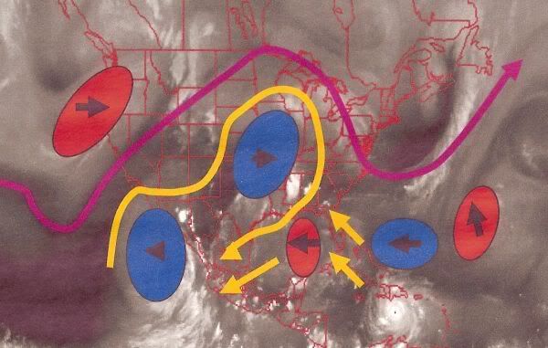
Diving a little deeper, and looking at the maps, there is a ridge over the Baha Peninsula in Mexico…It is bucking back against the trough over the east pacific. While the trough over the east pacific has moved little today…and upper level low off of Oregon and Northern California has pushed eastward. I wonder if when the ULL moves further east, it will respond by providing a digging trough over Utah and Texas…which would head to the east. Many models show the dissipation of this ULL, interestingly, the Nogaps does not…But the Nogaps also goes with a more southern path for Dean. Huh??? Also, the ridge over the middle states continues to head east, as does the trough over the western Atlantic. The one caveat here is that the Upper Level Low over the Gulf has progged westward; the Upper level low on the eastern side of the ridge north of Dean is starting to pull north. This has allowed the ridge north of Dean to Expand. This is significant, because this ridge may begin to expand and strengthen now...Just another Monkey wrench…However, if the trough in the Pacific moves westward, the upper low in the Gulf will get pulled in just the same as the one in the Atlantic and/or the forward westward progression of the upper level low may slow down again.
I hope this helps everyone somewhat, I’ve been in a bit of a hurry this evening, but I promised a post.